10 - British Columbia
20
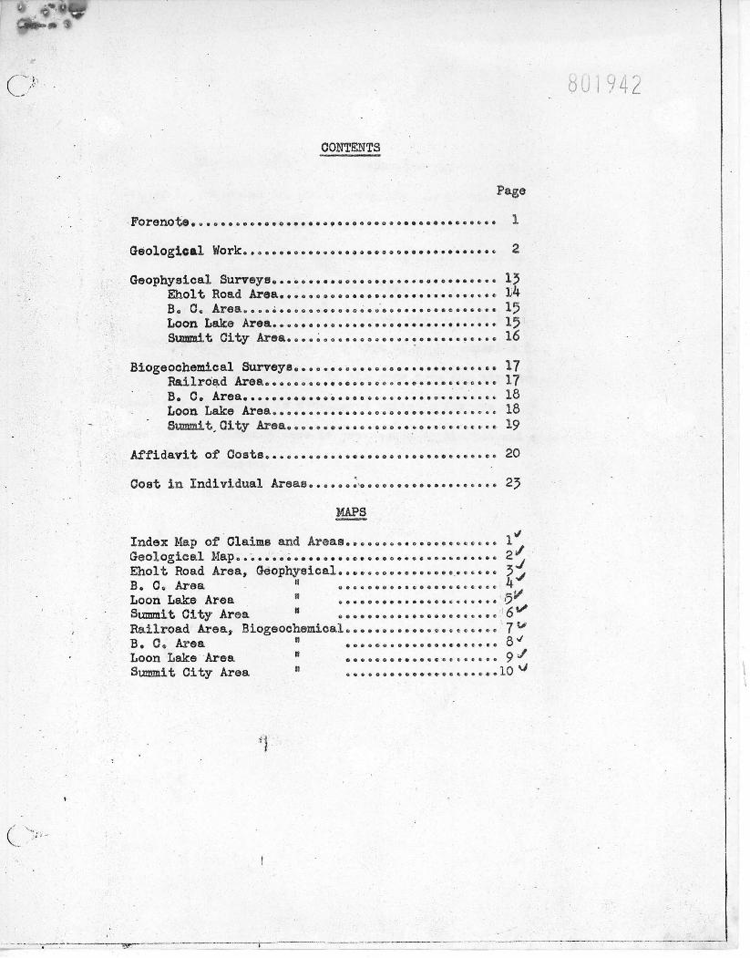
0 g *f CONTENTS Forenoto* . ..o. GsOlOgiC&X V /OrlCo •aeaaaoaeoaasaaaaeaaoa Geophysical Surveys».<. e ...aauvs..>?•:>«•.«eaB*a«>a«*c 13 Eholt Road Area. a.*. A Be Co 3.ucao ^.eot>aeees.ooeoeeB>..oeae.B ««<'t 1 J) Loon Lake Area <> 15 Summit City Area .... •••..•«..• .... •• .......... 16 Biogeochemical Surveys ••. • o - <• • 17 P&iXrOad ArSao eeeeeos.BoeeeBoaoaaaBB.a.s.o..*' 17 B B C. Area.... . . * « . • • • » . . co.»»o ...B .o .«..t*«* it- 1 Loon Lake Area.•••'•••••..*••••• •>.•••••« ...... 18 SUTBWi. t^ City Area. »oeoeeB«to©oooe.B.o»aoe.s **e« 19 Affidavit of Costs..... Cost i n Individual Areas.... O O (J 0 6 O O C S E 4S O i MAPS Index Map of Claims and Areas,..„... Geological Map 0 * ».•<.« ....... ,••**>. B .e<. Eholt Road Area, Geophysical.«•„,, e . B. C« Area " «.«.••*. Loon Lake Area •••••••• Summit City Area ........ Railroad Area, Biogeochemical*• .. • *. B. C« Area " ....... Loon Lake Area " • Summit City Area R ....... e . o c e » t- t 4 ....... . . « B * * « c » e a • • * •*..««< B . B a a c * a • a o e t e e a • . o • a 20 25 1* 10 ^ 1 1
Transcript of 10 - British Columbia
0 g*f
C O N T E N T S
Forenoto* . . . o . GsOlOgiC&X V/OrlCo • a e a a a o a e o a a s a a a a e a a o a
Geophysical Surveys».<. e...aauvs..>?•:>«•.«eaB*a«>a«*c 13 Eholt Road Area. a . * . A Be C o 3 . u c a o ^ . e o t > a e e e s . o o e o e e B > . . o e a e . B « « < ' t 1 J)
Loon Lake Area <> 15 Summit City Area....•••..•«..•....•• .......... 16
Biogeochemical Surveys ••. • o - <• • 17 P&iXrOad ArSao e e e e e o s . B o e e e B o a o a a a B B . a . s . o . . * ' 17 BB C. Area.... . . * « . • • • » . . c o . » » o . . . B . o . « . . t * « * i t - 1
Loon Lake Area.•••'•••••..*••••• •>.•••••«...... 18 SUTBWi. t ^ City Area. » o e o e e B « t o © o o o e . B . o » a o e . s * * e « 19
Affidavit of Costs..... Cost i n Individual Areas.... O O (J 0 6 O O C S E 4S O i
MAPS Index Map of Claims and Areas,..„... Geological Map0* ».•<.«.......,••**>.B.e<. Eholt Road Area, Geophysical.«•„,,e. B. C« Area " «.«.••*. Loon Lake Area •••••••• Summit City Area ........ Railroad Area, Biogeochemical*• .. • *. B. C« Area " ....... Loon Lake Area " • Summit City Area R .......
e . o c e » t- t 4
. . . . . . .
. . « B * * « c » e a • • * • * . . « « < B . B a a c * a • a o e t e e a • . o • a
20
25
1*
10
1
1
Sho goology l a the aocoapaaying oap vaa r-\px*d by Sr. v. H, idhj te and Sr. a* H* $«r*pfai»* So portion o£ t% «*aa taken froa onjr prsrljus work. Pturtienlar attention *«e paid to eco^oaio problem, ami l i t t l e - <>r no attention vol paid to probleae whica ara purely academic.
The objoot of the geological aapp*^ wan t» deten&lne by extrapolation van* typo of rocks? underlie the large arena of ovsrtaurd«u» I f the rook type ana structure under the overburden le eeneidered suitable for ore «Htea
thai the overburdened area le proapeot<»d by biochenlcal and geophysical aetbado*
2hc geology « u a*pj>«d directly onto r-^tt * tjrpe cnriul photographs, and transferred onto a thousand foot to tha Inch sap aade from tha photographs by iliot agraphia SUrvc; j (We* *ru) Ltd.
£hotO£rephs am approxisately one tha. *. vi 1 v t to tha
inch i n tha cantor hat tha scale i s distorted inert *e. ,1y towards
the herders of each photograph* I f r e l i e f i n the area covered by
a photograph i i great, the distortion i s not consistent gevsver,
sapping directly oats photographs was found very sff i e l a a t . So
surveying was necessary; position* could he 'apot^&d* on the
photograph by shape of open areas and by tree configurations.
Outcrops were United practically to the o>sn arses and thus are
easily found when one aseo the ]&oto«raphs.
Key points, points which oouM as) fx&ad accurately on
both ths photograph and the th^tsand scale Las&naap, wer#
tc trsmsfor the geology frew the photos* ts X*2 oase sap. The
accuraay of transferring fynsi thd distorted photographs to the
presumably aocurate baas aap was controlled by using as l a r ^ s a
nuab«r of key points as possible, anU by U n i t i n g aappin4 i the
cantor of a phctotgraph, where distortion i s loss.
» 2 •»
Tfcs geology of tha area has ' een described i n Q. S, C. Euaa.Heport 1901 3Boundary Creek P a t r i o t '
V W. Brook; ©. 3. C. Keaoir a , 1912 - §Phoenix 1 by fceHeyi end 6. 8. C. paper h5-20# * Greenwood Phoenix Area*
by P. A. Hoftattghton.
Ksferenoes are aadcs particularly to tlw las t mentioned report and i t l a aaeuned that a l l these reports have been studied I the following report i s read. She formation names used by Lefioy ha-s-o been continued i n this report. She formation* are as follower
H f f l HM.MWg ^ala««>oi« the Knob H i l l andeeites and cherts with nine* lines tens and
a r g i l l l t e are very fractured, contorted, and generally mu iaacrphosed*
In very few places can codding be determined. *he chert and lino stone
are knotted and 1 sassy; jio hcrlson sarkurs were founds
m^summm paia#o*oic The origin of the so called •chert and Jasperlod* of the
Brooklyn Foraation ? qusstl >a*d. Mcilaughton has grouped the Knob
H i l l with the Brooklyn. He states "Host of the Paloosole sediaeatary and volcanic rocks have undergone tsxtural and nlneralagical ohan^es since thoir c^uaolidat1)n. Thoy have been partly to ooopletely s l l l c i f i o d to fona ^asperiod and chert over wide aretva. This s i i i c i f l c a t i o n has so completely changed their original charaotor that i t i s impossible i n nany places to distinguish altered linestones and a r g i l l l t e a froas altered volcanic rocks.*
3
and also *l% has no*? h»«fi founds (X) that Itaestoae, a r g i l l i t e , l & t l t e , and andsslts have a l l been altered leca i i y to jasperlod; aad (2) th-t $hs JasperiodS iamadlately below the argil 1itss that had been napped wito the Haahtde formation were famed by the 8iliclfic»tlaa of argil1itee, not llasst>ae c and, therefore, do not indicate that the a r g l l l l t e a (fiawhide formation) are younger than the limestones (Brooklyn fori£atl;a)"
The JSrocklyn formation consists of?
Itiasst&ns • thin bedded, nmssivs, and conglomerate (formerly called brecciated*)
Oc^slcaerate - pebbles of sa?t WJ& or limestone i n a nutria of g r i t and c andssits and or lines tone (formerly called chart jasperiod breccia)
Sreywacks * (or gr i t ) • i n places andssltlc Shale Chert 5he oongloae.Ate, with intsrsea^ed gpreyvacks, '.-art, and shale,
i s very widespread, as may be observed on the aocoapanyl^.-; nap. It i s not Halted tee the ainsrallzsd areas, but Is found i n nany other areas i n the .Boundary d i s t r i c t , even beyox-i the area a .v J .
Bedding i s oonmon in nest of tha rocks. Sue type* of sediment subset deltaic deposition but no structures s.'.&gsstMg doltaic deposition, except a few places of possible scuur aad f i l l , wore found. Some of the beds are d i s t i n c t l y lenticular.
$hw conglomerate ssrite special atuitioo, as I t hsu been called a
ch«rt and Jasperlcd 'bs tccia i n previous work. She evidence for thie
identification nay he fotv.fl i n the reports of Motfaughfrcu aavi LeBoy.
Evidence that the oocglo'i£:.*ats i s a ecdii**:»4 In ats follcwss
• * -
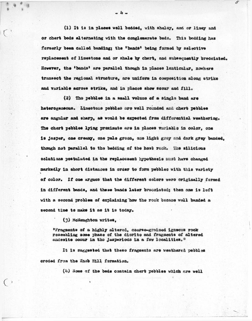
(1) I t l a l a place* v e i l bedded, with sholay, aad or limey and or chert bede alternating with the conglomerate beds. This tedding ha* formerly been called banding; the •bands8 being formed by a elective replacement of limestone and or shale by chert, and subsequently brscelatec. However, the •bands* are parallel though i n places lenticular, nowhere transect the regional structure, are uniform i n composition along strike and variable serosa strike, and i n places show scour and f i l l *
(2) She pebbles In a small volume of a single band arc heterogeneous. Ximeoti. i pebbles ore well rounds* and chert pebbles are angular and sharp, as would be expected from differential weathering, lbs chert pebbles lying proximate are i n plaices variable in color, one i s Jasper, oas creamy, one pals groan, one ligh t gray and dark grey banded, though not parallel to the bedding of the host rock. ... t s l l i c l o a s solutions postulated i n the replacement hypothesis burnt have changed narkedly In short distances i n order to form pebbles with this variety of color. I f ens argues that the different colors wars originally formed i n different bands, and these bands later brecclateds then one i s l e f t with a second problem of explaining how the rock became well banded a second t i n * to make i t as i t i s today.
(3) Mc&xughton writes, "fragments of a highly altered, coarse-grained igneous rock resembling some phase of the d l a r l t c and fragments of altered aadeslte occur i n the Jasperiods i n a fsw l o c a l i t i e s * *
It 1* suggested that these fragments are weather*1 pebbles
eroded from the Inob H i l l formation.
(k) Some of the beds contain chert pebbles which ore well
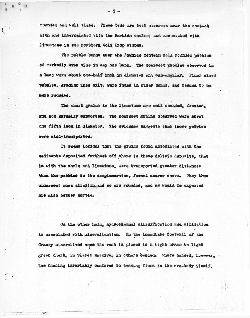
- 5 -
rounded aad well slaed. These beds are best observed near the contact with aad Intercalate with the Pawhide afcmleaj and associated with line?tone In the northern. Cold Drop stopss.
She pebble hands near the Sawhide contain wall rounded pebbles of markedly even siss i n any one band. The coarsest pebbles observed In a band were about one-half inch i n dli-^eter and one-angular, yiner sised pebbles, grading into s i l t , wsrs found i n other bands, and tended to be mere rounded.
She chert grains i n the ll&setsms) are wall rounded, fretted,
end not mutually supported. The coarsest grains observed were about
one f i f t h inch i n diaasta^. The evidence suggsets that these pebbles
were wind-transported.
It seems logical that the grains found associated with the ssdiments deposited furthest off shore In these deltaic -spoolts, that i s with tha shale and limestone, were transported greater distances than the pebbles i n the conglomerates, formed nearer shore. They thus underwent acre abrasion, and so are rounded, and as would be expected are also better aorta*.
On the other hand, hy tiro thermal s i l l o i f l c a t ion and s i l l e a t l o a
i s associated with mineralisation. In the Immediate footwall of the
Granby mineralised zees the rock i n places i s a l i g h t creex to lig h t
green chert, i n places massive, i n others banded, fehere banded, however,
the banding invariably conforms to banding found i n the ore-body I t s e l f ,
f
i « * * - 6 -
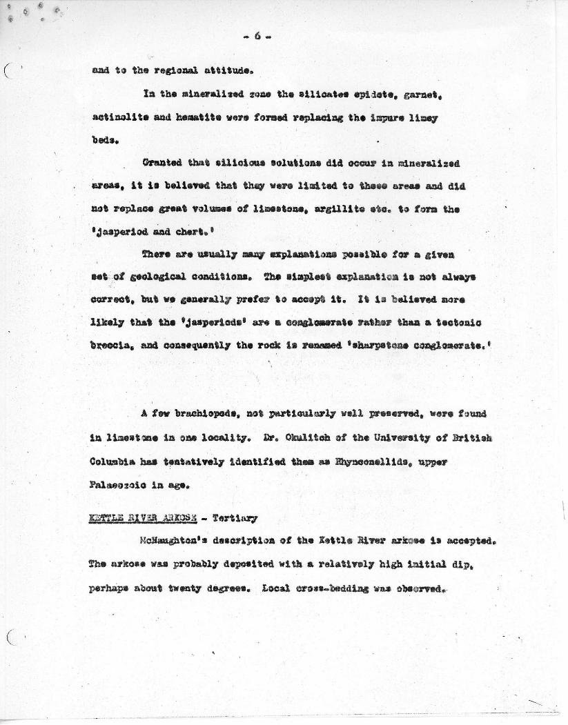
aad to the regional attitude.
In the mineralised xone the sil i c a t e s epiiote. garnet, aotinolite and hematite vera formed replacing the ispurs limey beds,
Granted that eUloioue solution* did occur In mineralized areas, i t i s believed that they were limited to these areas and did not replace great Volumes of limestone, arg i l l i t e etc. to form the 'jasperiod and chert. 8
There are usually many explanations possible for a given set of geological conditions. The simplest explanation i s not always correct, but we generally prefer to accept I t . Zt l a believed mors l i k e l y that the jasper!ode 1 are a conglomerate rather than a tectonic breccia, and consequently the rock Is renamed •sharpstone conglomerate,'
A few brachlopode, not particularly v e i l preserved, were found
In linest-anc i n one l o c a l i t y . 2r. Okulitoh of the University of B r i t i s h
Columbia has tentatively Identified than as Bhyneonalllds, upper
Palaeozoic i n age.
K^ms 51 V3n jggggg - Tertiary McHaughton's description of the Kettle Hirer arJesse Is accepted.
The arkose was probably deposited with a relatively high I n i t i a l dip,
perhaps about twenty degrees. loc a l cross^beddlng was observed.
.Associated with the Midway Volcanics are pAloakite, syenite,
and audita porchyyy dykes aad s i l l s . , 2a places the pulaakite dykee
grade lato tha volcanics, i n other places, contacts are sharp* The
hypabyssals and tha volcanic a are probably genetically related,
OAS - Age Unknown
MoSaughtoa states °The Tertiary sedimentary and Igneous
rooks are younger than the ore deposits but glvec no evidence
to support ths statement* The present work has produced no evidence
as to whether the ere deposits arc older or younger than tha Tertiary
rocks*
£ata Suggesting that ths ore nay be older are as follows!
Ko exposures have been found i n which mineralisation transects or rsplaoss
Tertiary rocks. A few places were noted i n which ore appeared to be of
higher grade close to pulaakite dykee9 but these oeoursacee say be
coincidence for patches of 'high-grade1 aloe occur with no relation to
pulaakite. In two underground l o c a l i t i e s i t appeared that the pulaakite
had picked up inclusions of ore. However, the rock i n these places was
so altered and gougey frou faulting that Identification of the pulaakite
was uncertain and the ore inclusions ma have been fault '"drag.1
2ata suggaetiag that the ore deposits may be younger are as
follows* The ore bodies at Ihoenln are within a few hundred feet of
the footwall contact of the Tertiary rocks. Zt i s possible that at
Phoenix the Tertiary rooks provided a •cap1 for the mineralising
solutions* ths Tertiary reanaate are lenticular, and irregularly
distributed throughout the Boundary country. It i s not known i f the
2. 0. basin area near Shalt was covered by fartiary rooks, and thus
the structural relations of the ore found i n Ore vonora, z &aa, and
B. C. tainem to the tertiary rooks i s unknown. The pulaakite dykes
l a the mineralized area are i n tunny places so strongly altered to
clay minerals aad s e r i c i t e that they are d i f f i c u l t to identify u n t i l
one becomes familiar with then, this alteration may be denteric or
i t nay be caused by the mineralising solutloast i t Is certainly
abundant i n the mineralised area and lacking away fr<*a i t .
mssam> Our mapping indicates thnfc She eldest Knob H i l l group of
volcanics and cherts i s conformable., at least l a placet?, with ths
overlying lenses of Bawhlds shales, which in turn are conformable to
the overlying Brooklyn formation. Where the Bawhide shales are absent,
ths Knob H i l l gradee into the Brooklyn format Ion.
In the Knob B i l l group near the contact with ths overlying
Brooklyn formation some of the chert beds show a vague mottling
suggesting that the beds originally could have been oher^ pebble
conglomerate, i n which the pebbles have almost completely fused, l a
other places, well v i thin tha Knob JU1X group, notably west of Snob H i l l
along the power l i n e , iaterbedded with ancc H i l l chart aad andeslte ore
beds of aharpstone conglomerate. Zn a few outcrcpe the contact between
Snob H i l l and Brooklyn i s gradational; Brooklyn formation sharpstoae
conglomerate formed from chart pebblae l a nndesitie matrix grades
lata aadeeite containing no pebbles.
Only one a or lot of outcrops, near Hartford Junction on ths
old railroad grade f r o * Summit City, shows a contact between Knob-
H i l l and Hawhids formations. Ths rocks exposed are such that one
cannot distinguish where ths Enob H i l l andesltss term!nets and ths
Rawhids shales begin. The northernmost of the outcrops arc massive
andssite, and ths southernmost arc bedded shales.
She Bnwhide Brooklyn contact i s best observed l a ths many
small outcrops between the dawhlds mine and ths West Xootenay power
l i n e * Beds of well sorted ligh t grey chart pebbles are common i n the
upper strata of ths Hawhidsj and tht* bidding i s almost oriioatal,
Sear ths contact with the overlying JBrooklyn formation these beds
bsooms mors abundant. She Ssvhlde formation, predomixu: ely shale
with minor conglomerate* grades into ths Brooklyn formation, pre
dominantly conglomerate with minor shale*
Ths Tertiary rocks arc separated from the ftalaeosoio by an
unconformity. P a r t i a l l y oxidised rubble l a found at the base of ths
Kettle Hlver arkoss.
The regional trend l a the mapped area i s north-south, with
dips steeply east, bolt exceptions to this attiteds were noted, and
indicate a series of folds with axial l i n e plunging ten to twenty
( , • •- •• • 1
• 10
degrees north.
Ths Brooklyn formation south of SVin Creek forme an east
to north east dipping monocline, with an apparent plunge ten to twenty
degree* north. At the western contact with the Knob S i l l group the
Brooklyn formation dips sixty degrees sasterlyi further east the dip
flattens to f i r e or ten degrees north-easterly. Ths topography i s
such that ths formation appear* as a northerly plunging syncl i n s r The
contact with Knob B i l l group and nawhida formation forms a ssai-oircle
extending from west of Khofe H i l l « Irons idee mine) through Grey 5egle(
War Eagle, Monarch, Rawhide, to Curlew and Snowshoe mines.
A structural •break8 probably occurs i n ths valley of Twin Creek, for the fifteen hundred foot thick hand of lime*ton* west of Brooklyn does not continue acroes the valley to ths south.
Ths Brooklyn formation extending i n beads from Xnoenix towards Shalt dlpe steeply east i n most places, cut synclinal and a n t i c l i n a l r o l l s with north-trending axes were noted (see map)*
The large copper ore bodies found i n ths d i s t r i c t arc replace
ments of lime*tone and impure limey beds of ths Brooklyn formation*
These ore bodies include ths .Brooklyn, In lines ton* at the contact of
sharpstone conglomerate; the Stemwlndsr at the contact of limestone
conglomerate with chert sharps tone conglomerate; ths Cranby In what
are probably impure limey and andesltlo beds intercalated with sharp*
stone conglomerate; the Ore Do norm and JSama i n limestone at the contact
with intrusive diorite; and the 3. C. mine i n limestone.
CJaCLUSISnSl ,
2h* area i s very complicated structurally, aad ths structures are d i f f i c u l t to interpret bectatsc of the metaatorphisa of a one of the formations and because of ths lack of outcrops*
However, ths geological study has indicated that ths over* burden covered areas along ths old Bholt road; and i n tha 3. C. basin are ths meet promising for application of geophysical and Mogsechemical work, These regions are close to known ere bodies, and are probably underlain by the Brooklyn formation*
The Geophysical work was dona 07 Hr. Pred 5. torn, 2 7 St. Clemens Ave., Toronto 12, Ontario, and ono assistant. Mr. ittaa uaad a calibrated angnetosotor and self-potential equipment fro* Sharpe Inatruoanta Ltd, 690 Bay St., Toroatn*
mssxm Magnetometer work preceded sslf-potentlal work i n a l l places*
Moat of tha Kagnstomster work followed biogeoohnmioal work, with exception i n tha Shalt road area, where no Uogeoohenioal work has ceen completed.
A main bass station was made near the campsite, and the Instrument est to the same reading on this station preceding and following each f i e l d day. local case stations were mads i n each area surveyed and calibrated to ths main bass. Checks were mads several times a day at ths local bass stations to determine ths Variation i n ths diurnal, and this variation was taken into account In calculating the magnetic Intensity of oaeh station.
The location of the individual areas i s shown on ths accompany-*
ing claim jap. Stations In the B. Summit City, and Loon Lake areas
were taken at 50 foot intervals on lines 100 and 200 feet apart as
shown on the accompanying osape. The lines were surveyed with 3runtoa
compass, cut out, and pickets put i n at the stations by *f. *. KoArthur
and associates of Greenwood. Tha pickets are numbered, and corres
ponding numbers are shown on ths blogeochemicaX maps* Ths geophysical
stations and biogsoohsmical stations correspond In a l l places where
both nsthcds have been applied. A bass l i n e was surveyed i n by Sruntcn and taps along ths
Eholt road, and Bruntsa and taps cross lines to ths west vers surveyed l a from the base l i n e . A tree has been biased and numbered - X 1, £ 2,
& 1, S2 t e t c at each station, and the number i s shown tc locate these Stations on the accompanying map of the tiholt Scad area.
Magnetic anomalies war* testsd for electric current by self-potential survey. Ths results of ths self-potential survey are shown on the geophysical maps - negative readings In m i l l i v o l t s are recorded below the mapped lines and at the stations.
Interpretation of the geophysical surveys of each area Is as follows! (Please refer to the map of each area).
Out crape are few, aonll, and altered, so that Interpretation of
geophysical data i s necessarily hypothetical. The area i s on strike of
ths Granby mine. At least one of the outcrops i n highly altered lime
stone. The weak Magnetic anomalies trend parallel to the regional strike
l a neighbouring areas where ou to rope occur, and thsss anomalies could be
caused by either replacement ore lenses with low content of magnetic
minerals or slight variations i n amount of magnetic minerals i n the country rock.
Self potential survey over these magnetlo anomalies gavs very
ft
** 3 **
strong self-potential anomalies, not exactly co-incident nut invariably close to tha sagnetlc anomalie*.
t h i s area certainly warrants ehsoking with a biogcochemical survey, and should hs taatsd with a diamond d r i l l unless ths rssults of ths Dioesoohanlcal survey are completely discouraging,
aV 8*MM
She magnetic intensity shows considerable variation with no oonslstaat trends. Several of ths magnetic highs arc on or d oss to outcrops of pulaakite dykes, tat stagnstio lows also occur on ths sans dyke or by similar dykes. This leads ts the conclusion that ths dykes are •phasey' that Is, vary i n content of magnetic minerals from plans to place. In neighbouring areas the dykes are numerous, and dip f l a t l y west. They would tend to blanket cut possible anomalies from under-* lying ore bodies i n the steeply dipping -Brooklyn formation.
The selfopotsntial survey did not disclose any anomaly.
The entire area Is much mors magnetic than ths adjoining areas
where fresh limestone outcrops* Variations i n ths magnetio intensity
trend north south, parallel to the regional attitude of the bedding.
Pulaakite dykes, dipping f l a t l y westerly, are very abundant i n outcrops
north and south of the area, and probably occur i n the area. These
dykes nay produce taji anomalies.
Ths strongest magnetic •high 1, i n the aouth-west corner of ths
map, i s very close to a p i t shewing fresh basalt. Basalt has been found
a ' - 4 -
|" associated with limestone elsewhere i n the d i s t r i c t , and i t , as well as the pnlaskite, nay cans® the anomalies.,
However, the area i s on strike of the Oro Denora, Soma, and Jumbo mineralized zone, and notwithstanding the above mentioned discrediting factors, may merit a check by diamond d r i l l i n g where magnetic and biogeochemioal anomalies are proximate.
Sami* City Tory l i t t l e magnetic variation was found. Ths high i n the
south-west corner may be caused by an angite porphyry dyke which out
crops about one hundred feet south usst of the high. Uc outcrops were
found i n the area, but the regional geology Indicates OCiat the area i s
underlain by limestone. Ho self-potential anomalies were found.
/Ax.••••• *' '<•
Dr. R. H. Seraphim Dr. D. F c Kidd ' /' 7^7f.
TOW"'"
(
tmmsaam A tare* man crew was employed for blag economical surveys.
Mr. T. Allan, who had one season1 S previous experience, did a l l analyses. Hr. A. wason, mining engineer, and an assistant eoUsctsd samples and did f i e l d surveying.
Surveying followed the method described far ths 5bol% Bead area. Samples were taken from ths yoar-bef ore-last'a growth of twig from as large n tree- as possible, and preferably f i r . a l l samples vers analysed by ths 41 thy sons method f s r both ooppsr and ziao, and ths Cut 2a ratio was computed* She method follows that dssorlbsd by Ife*. H. 7. Warren and Or. w. H* baits aad used by Dr. Whits i n his work for ths 3» C. DepS« of Mines during the 1950 fi«Xd season. A l l analyses are recorded the aoccapauying map*
Ths Bailroad Area i s ths only area surveyed by Attwood which wo wish to record. A l l other areas vers on orown-granted claims* tha area i s i n a belt of Brschlya limes tone, bancs favourable for ore deposits, but showed almost a complete lack of anomalous assay*. So
a
further work i s warranted In the imediate area.
wsmmm mam - auu agaiaaa aaa A^OCIA?^
9. S. HcArthar and anroilatas blogeoctattclcal surrey* vers don* with ths sans technique as that employed by AtWCSi. they vers Instructed In the technics by Dr» £• K* tfr?rcn aft ths Ontvsrofity of B r i t i s h Columbia. Surveying was don?? as cmfiorib?** i n procedure of i^opfi^sicai Surveys* Sr. M. Hsdlsy of ths 2. 0. Dept. of Mines has visited KcArthur's project, end Dr. W. H. White- has acted informally as ooatultant on several occasions.
Kr. McArthur has turned over bis data to Attvocd, and ws have -
co-piled I t and endeavoured to interpret i t . A a&p of each area Is included i n the report
An anomalous area of high Gat£m ratio i s found 0:a the southern portion of the sheet. Thin area Is Just off strike of ths £« C. ore body. Ths anomaly was later checked by Attvocd, aad similar results were obtained.
w. 2. HcArthur diamond d r i l l e d one hols under this anomaly,
but unfortunately cored pulaskite dyke under the strongest part of ths
anomaly, io cupifercus mine rale were noted i n ths pulaskite o? i n ths
sharps tone conglomerate on i t s contacts. She area does not merit further
work u n t i l the other more important areas have been Investigated.
lum Mm Am Blogeochemical anomalies i n this area trend nerth*oofe$h3 as
do the geophysical anomalies. Unfortunately, almost a l l the trees
AS"
- 3 -
along tha lake shore, where tha strongest anomaly wee found, are alder* Our experience srith anal/sec froa alder l a Halted-, but i t appears that the Cus Za ratio tends to have a greater range than the ratio froa other trees. Alder i s thus acrs sensitive than other trees, and perhaps too sensitive,
Ths area as sen tinned In ths import oft geophysical areas..,, merits further check, and should perhaps he diamond d r i l l e d where geophysical and bie^socheaical, anomalies coincide.
Summit C*tr Area
An anomaly trends north-south through ths area. However* about half of ths tress sampled i n this anomaly were aider, about which trees we have l i t t l e information.
the lack of ecoincidence of samgnstlo with biegea /lemioal anomalies, and tha complete lack of self*poteutisl anomaly, tend to die courage further work i n ths aren 0