Szlak zeglarski locje EN
104
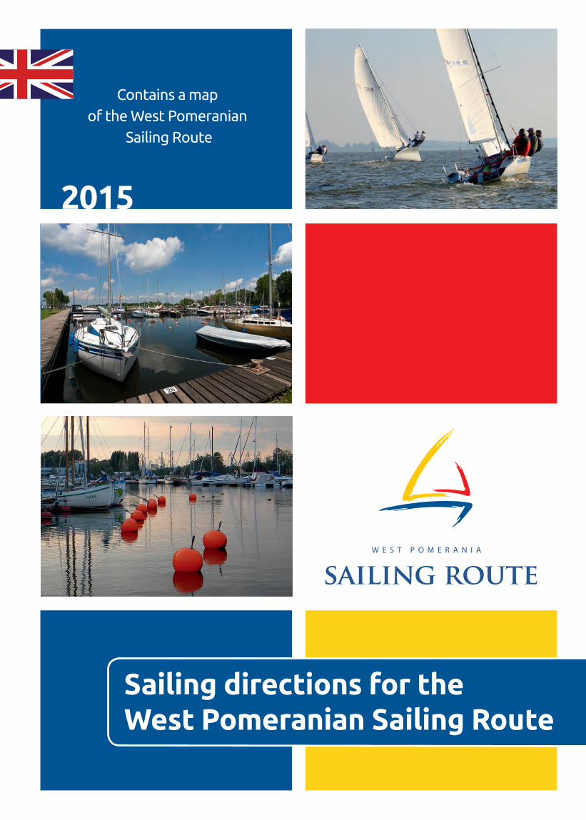
2015 Contains a map of the West Pomeranian Sailing Route Sailing directions for the West Pomeranian Sailing Route
description
Sailing directions for the West Pomeranian Sailing Route
Transcript of Szlak zeglarski locje EN
2015
Contains a map of the West Pomeranian
Sailing Route
Sailing directions for the West Pomeranian Sailing Route
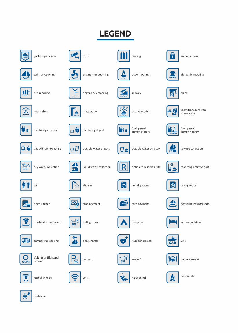
barbecue
yacht supervision CCTV fencing limited access
sail manoeuvring engine manoeuvring buoy mooring alongside mooring
pile mooring finger-dock mooring slipway crane
repair shed mast crane boat wintering yacht transport from slipway site
electricity on quay electricity at port fuel, petrol station at port
fuel, petrol station nearby
gas cylinder exchange potable water at port potable water on quay sewage collection
oily water collection liquid waste collection option to reserve a site reporting entry to port
wc shower laundry room drying room
open kitchen cash payment card payment boatbuilding workshop
mechanical workshop sailing store campsite accommodation
camper van parking boat charter AED defibrillator SAR
Volunteer Lifeguard Service car park grocer’s bar, restaurant
cash dispenser Wi-Fi playground bonfire site
LEGEND
3
TABLE OF CONTENTS
Legend� � � � � � � � � � � � � � � � � � � � � � � � � � � � � � � � � � � � � � � � � � � � � � � � � � � � � � � � � � � � � � � � � � � � � � � � � � � �2
Introduction � � � � � � � � � � � � � � � � � � � � � � � � � � � � � � � � � � � � � � � � � � � � � � � � � � � � � � � � � � � � � � � � � � � � � 5
Description of the West Pomeranian Sailing Route � � � � � � � � � � � � � � � � � � � � � � � � � � � � � � � � 7
Important information about the West Pomeranian Sailing Route � � � � � � � � � � � � � � � � � �8
Time and distances between ports � � � � � � � � � � � � � � � � � � � � � � � � � � � � � � � � � � � � � � � � � � 8
Maximum draught for ports and the approach fairway � � � � � � � � � � � � � � � � � � � � � � � 9
Communication � � � � � � � � � � � � � � � � � � � � � � � � � � � � � � � � � � � � � � � � � � � � � � � � � � � � � � � � � � � �10
Maritime Search and Rescue Service – SAR � � � � � � � � � � � � � � � � � � � � � � � � � � � � � � � � � �11
Volunteer Lifeguard Service Units � � � � � � � � � � � � � � � � � � � � � � � � � � � � � � � � � � � � � � � � � �12
Weather forecast� � � � � � � � � � � � � � � � � � � � � � � � � � � � � � � � � � � � � � � � � � � � � � � � � � � � � � � � � � �13
Permit for recreational fishing � � � � � � � � � � � � � � � � � � � � � � � � � � � � � � � � � � � � � � � � � � � � � �13
Use of UKF radio� � � � � � � � � � � � � � � � � � � � � � � � � � � � � � � � � � � � � � � � � � � � � � � � � � � � � � � � � � � �13
Information sources – information charts publications, internet sites � � � � � � � �13
Blue Flag � � � � � � � � � � � � � � � � � � � � � � � � � � � � � � � � � � � � � � � � � � � � � � � � � � � � � � � � � � � � � � � � � �14
Refuelling stations alongside the Route accessible directly from water � � � � � �14
Important telephone numbers � � � � � � � � � � � � � � � � � � � � � � � � � � � � � � � � � � � � � � � � � � � � � �14
Border crossings on the Route � � � � � � � � � � � � � � � � � � � � � � � � � � � � � � � � � � � � � � � � � � � � � �15
Bridges and ferries � � � � � � � � � � � � � � � � � � � � � � � � � � � � � � � � � � � � � � � � � � � � � � � � � � � � � � � � �15
Descriptions of ports of the West Pomeranian Sailing Route � � � � � � � � � � � � � � � � � � � � � � 18
Widuchowa� Ognica Wharf � � � � � � � � � � � � � � � � � � � � � � � � � � � � � � � � � � � � � � � � � � � � � � � � �18
Widuchowa� Widuchowa Wharf � � � � � � � � � � � � � � � � � � � � � � � � � � � � � � � � � � � � � � � � � � � � �20
Gryfino. Town Wharf � � � � � � � � � � � � � � � � � � � � � � � � � � � � � � � � � � � � � � � � � � � � � � � � � � � � � � �22
Szczecin� Yacht Harbour in Szczecin� � � � � � � � � � � � � � � � � � � � � � � � � � � � � � � � � � � � � � � � � �24
Szczecin. Marina Gocław � � � � � � � � � � � � � � � � � � � � � � � � � � � � � � � � � � � � � � � � � � � � � � � � � � � �26
Szczecin� Sailing Centre � � � � � � � � � � � � � � � � � � � � � � � � � � � � � � � � � � � � � � � � � � � � � � � � � � � � �28
Szczecin� Camping Marina PTTK � � � � � � � � � � � � � � � � � � � � � � � � � � � � � � � � � � � � � � � � � � � � �30
Szczecin� Scouts’ Maritime Centre � � � � � � � � � � � � � � � � � � � � � � � � � � � � � � � � � � � � � � � � � � �32
Szczecin� Yacht Club of Szczecin Academic Sports Association � � � � � � � � � � � � � � � �34
Szczecin� Marina Club � � � � � � � � � � � � � � � � � � � � � � � � � � � � � � � � � � � � � � � � � � � � � � � � � � � � � � �36
Szczecin. Marina Pogoń � � � � � � � � � � � � � � � � � � � � � � � � � � � � � � � � � � � � � � � � � � � � � � � � � � � � �38
4
Szczecin� Marina Lubczyna � � � � � � � � � � � � � � � � � � � � � � � � � � � � � � � � � � � � � � � � � � � � � � � � � �40
Police� TKKF Olimpia� � � � � � � � � � � � � � � � � � � � � � � � � � � � � � � � � � � � � � � � � � � � � � � � � � � � � � � �42
Police� Town Harbour in Police � � � � � � � � � � � � � � � � � � � � � � � � � � � � � � � � � � � � � � � � � � � � � �44
Stepnica. Yacht harbour at the Młyński Canal � � � � � � � � � � � � � � � � � � � � � � � � � � � � � � � �46
Stepnica� Yacht Harbour in the Fishing Basin � � � � � � � � � � � � � � � � � � � � � � � � � � � � � � � � �48
Stepnica. Szuwarek Harbour � � � � � � � � � � � � � � � � � � � � � � � � � � � � � � � � � � � � � � � � � � � � � � � �50
Trzebież. Port in Trzebież � � � � � � � � � � � � � � � � � � � � � � � � � � � � � � � � � � � � � � � � � � � � � � � � � � �52
Trzebież. Main Sailing Centre in Trzebież� � � � � � � � � � � � � � � � � � � � � � � � � � � � � � � � � � � � �54
Nowe Warpno� Yacht Harbour in Nowe Warpno � � � � � � � � � � � � � � � � � � � � � � � � � � � � �56
Nowe Warpno� Marina Nowe Warpno � � � � � � � � � � � � � � � � � � � � � � � � � � � � � � � � � � � � � � �58
Nowe Warpno� Pier � � � � � � � � � � � � � � � � � � � � � � � � � � � � � � � � � � � � � � � � � � � � � � � � � � � � � � � � �60
Nowe Warpno� Nowe Warpno Port � � � � � � � � � � � � � � � � � � � � � � � � � � � � � � � � � � � � � � � � �62
Wolin� Marina Wolin � � � � � � � � � � � � � � � � � � � � � � � � � � � � � � � � � � � � � � � � � � � � � � � � � � � � � � � �64
Wolin� Marina Wolina (former Albatros School Sports Club) � � � � � � � � � � � � � � � � � �66
Wolin� North-Western Wharf � � � � � � � � � � � � � � � � � � � � � � � � � � � � � � � � � � � � � � � � � � � � � � �68
Międzyzdroje. Wapnica – Międzyzdroje � � � � � � � � � � � � � � � � � � � � � � � � � � � � � � � � � � � � � �70
Świnoujście. Yacht Harbour in Łunowo � � � � � � � � � � � � � � � � � � � � � � � � � � � � � � � � � � � � � �72
Świnoujście. Yacht Harbour in the Northern Basin� � � � � � � � � � � � � � � � � � � � � � � � � � � �74
Świnoujście. „Kotwica” Navy Yacht Club branch in Świnoujście� � � � � � � � � � � � � � � �76
Świnoujście. Cztery Wiatry Yacht Club � � � � � � � � � � � � � � � � � � � � � � � � � � � � � � � � � � � � � � �78
Świnoujście. Marina Karsibór � � � � � � � � � � � � � � � � � � � � � � � � � � � � � � � � � � � � � � � � � � � � � � � �80
Dziwnów. Marina Dziwnów � � � � � � � � � � � � � � � � � � � � � � � � � � � � � � � � � � � � � � � � � � � � � � � � �82
Dziwnów. Marina Polmax � � � � � � � � � � � � � � � � � � � � � � � � � � � � � � � � � � � � � � � � � � � � � � � � � � �84
Dziwnów. Seasonal Harbour in Dziwnów � � � � � � � � � � � � � � � � � � � � � � � � � � � � � � � � � � � �86
Kamień Pomorski. Marina Kamień Pomorski � � � � � � � � � � � � � � � � � � � � � � � � � � � � � � � � �88
Mrzeżyno. Mrzeżyno Seaport Authority � � � � � � � � � � � � � � � � � � � � � � � � � � � � � � � � � � � � �90
Dźwirzyno. Port Dźwirzyno � � � � � � � � � � � � � � � � � � � � � � � � � � � � � � � � � � � � � � � � � � � � � � � � �92
Kołobrzeg. Marina Solna Kołobrzeg � � � � � � � � � � � � � � � � � � � � � � � � � � � � � � � � � � � � � � � � �94
Darłowo. Darłowo Seaport � � � � � � � � � � � � � � � � � � � � � � � � � � � � � � � � � � � � � � � � � � � � � � � � �96
Sailing spots and a concrete ship � � � � � � � � � � � � � � � � � � � � � � � � � � � � � � � � � � � � � � � � � � � � � � � � � �98
Regatta calendar � � � � � � � � � � � � � � � � � � � � � � � � � � � � � � � � � � � � � � � � � � � � � � � � � � � � � � � � � � � � � � � 100
5
INTRODUCTION
The dynamic infrastructure development of tourist ports of the West Pomeranian
Sailing Route contributed to the attractiveness of the sailing conditions in the region�
For thousands of water sports enthusiasts West Pomerania is the most favourite area
for summer and weekend outings. For others the region remains as yet undiscovered
and still alluring thanks to its unique set of assets. Without a doubt, there is no better
spot for all those who wish to enjoy their passion for sailing and to take in the charms
of West Pomerania�
This publication is dedicated to sailors and water motor sports enthusiasts� It was
created with the aim of presenting the information about the local water bodies, sailing
conditions and port infrastructure� The publication also contains information concerning
mooring at all the marinas and harbours of the West Pomeranian Sailing Route along
with symbolically represented services rendered by individual locations� There are
also descriptions of ways of port approach, working hours of the infrastructure and
institutions related to water transport as well as a lot of other information that every
sailor will find important.
We are convinced that the information will be useful, thereby increasing the safety
and comfort of those spending time on the waters and at yacht harbours of the West
Pomeranian Sailing Route�
Happy boating

6
7
The West Pomeranian Sailing Route
The West Pomeranian Sailing Route is a network of over thirty ports and yacht harbours
on the Oder, in the environs of the Szczecin Lagoon and on the Baltic coast� The distances
between them do not exceed 20-30 nautical miles, i�e� several hours of easy sailing�
It enables moving from one port to another within one day and ensures safe, recreational
sailing not only for experienced yachtsmen, but also for slightly less experienced yachting
enthusiasts. The water reservoirs on the Route offer a lot of variety, they are full of
picturesque spots and for those keen to experience a true maritime adventure – there are
also some difficult challenges on the way.
Ports and yacht harbours feature user-friendly, modern, and recently modernized
infrastructure with extensive service facilities� They are located in places of great tourist
attractions, offering a multitude of interesting leisure activities.
The West Pomeranian Sailing Route is a splendid place to practice water sports, to relax
and have a good time� Its growing popularity clearly shows that a new model tourist brand
was created in the West Pomeranian Voivodeship�
www�marinas�pl
8
TIME AND DISTANCES BETWEEN PORTS Distances are given in nautical miles for the routes designated with navigational marks. The time was calculated for
favourable wind of up to 5 B and for a 8-meter long yacht, sailing with an average speed of up to 5 knots.
Świn
oujśc
ie
Dziw
nów
Mrz
eżyn
o
Dźw
irzyn
o
Koło
brze
g
Darło
wo
Fairw
ay a
rch
I
Kam
ień
Pom
orsk
i
Wol
in
Fairw
ay a
rch
III
Now
e W
arpn
o
Wap
nica
Trze
bież
Step
nica
Polic
e
Lubc
zyna
Dąbi
e AZ
S
Szcz
ecin
Chr
obry
Em
bank
men
t
Świnoujście 18 NM / 4,5h
39 NM / 9,7h
42 NM / 10,5h
48 NM / 12h
82 NM / 20,5h
8 NM / 2h
23 NM / 5,7h
33 NM / 8,3h
16 NM / 4h
13 NM / 3,3h
21 NM / 5,2h
19 NM / 4,7h
23 NM / 5,7h
27 NM / 6,7h
32 NM / 8h
37 NM / 9,3h
35 NM / 8,7h
Dziwnów 39 NM / 9,7h 22 NM
/ 5,5h25 NM / 6,3h
31 NM / 7,8h
65 NM / 16,3h
29 NM / 8,3h
5 NM / 1,2h
15 NM / 3,8h
27 NM / 6,8h
32 NM / 8h
31 NM / 7,80h
31 NM / 7,8h
35 NM / 8,7h
40 NM / 10h
46Mm / 11,8h
52 NM / 13h
50 NM/ 12,5h
Mrzeżyno 39 NM / 9,7h
22 NM / 5,5h 3 NM
/ 1h10 NM / 2,5h
46 NM / 11,5h
Dźwirzyno 42 NM / 10,5h
25 NM / 6,3h
3 NM / 1h 6 NM
/ 1,5h40 NM / 10h
Kołobrzeg 48 NM / 12h
31 NM / 7,8h
10 NM / 2,5h
6 NM / 1,5h 33 NM
/ 8,3h
Darłowo 82 NM / 20,5h
65 NM / 16,3h
46 NM / 11,7h
40 NM / 10h
33 NM / 8,3h
Fairway arch I
8 NM / 2h
29 NM / 8,3h 25 NM
/ 6,2h14 NM / 3,3h
7 NM / 2,8h
6 NM / 1,5h
13 NM / 3,3h
11 NM / 2,8h
15 NM / 3,8h
19 NM / 4,8hn
23 NM / 5,8hn
30 NM / 7,5h
28 NM / 7h
Kamień Pomorski
23 NM / 5,7h
5 NM / 1,3h 25 NM
/ 6,2h 11 NM / 1,2h
23 NM / 5,8h
36 NM / 9h
29 NM / 7,3h
28 NM / 7h
32 NM / 8h
37 NM / 9,3h
39 NM / 9,8h
45 NM / 11,3h
43 NM / 11,8h
Wolin 25Mm 6,3h
15 NM / 3,8h 14 NM
/ 3,3h11NM / 3,2h 12 NM
/ 3h16 NM / 4h
17 NM / 4,3h
16 NM / 4h
20 NM / 5h
24 NM / 6h
27 NM / 6,8h
34 NM / 8,5h
31 NM / 7,8h
Fairway arch III
16 NM / 4h 7 NM
/ 2,8h23 NM / 5,8h
12 NM / 3h 13 NM
/ 3.3h12 NM / 3h
4 NM / 1h
8 NM / 2h
12 NM / 3h
16 NM / 4h
23 NM / 5,8h
28 NM / 7h
Nowe Warpno
13 NM / 3,3h 6 NM
/ 1,5h36 NM / 9h
16 NM / 4h
13 NM / 3,3h 28 NM
/ 6,5h16 NM / 4h
19 NM / 4,8h
24 NM / 6h
28 NM / 7h
27 NM / 6,8h
35 NM / 8,8h
Wapnica 21 NM / 5,2h 13 NM
/ 3,3h 29NM / 7,3h
17 NM / 4h
12 NM / 3h
28 NM / 7h 16 NM
/ 4h 20 NM / 5h
25 NM / 6,2h
29 NM / 7,3h
34 NM / 8,5h
31NM / 7,8h
Trzebież 19 NM / 4,8h 11 NM
/ 2,8h28NM / 7h
16 NM / 4h
4 NM / 1h
16 NM / 4h
16 NM / 4h 4 NM
/ 1h9 NM / 2,2h
13 NM / 3,3h
18 NM / 4,5h
16 NM / 4h
Stepnica 23 NM / 5,8h 15Mm
3,8h32Mm
8h20Mm
5h8Mm
2h 19Mm 4,8h
20Mm 5h
4Mm 1h 8Mm
2h13Mm 3,3h
18Mm 4,5h
14Mm 3,5h
Police 27 NM / 6,8h n 19 NM
/ 4,8h37 NM / 9,3h
24 NM / 6h
12 NM / 3h
24 NM / 6h
25 NM / 6,3h
9 NM / 2,2h
8 NM / 2h , 6 NM
/ 1,5h 12 NM / 3,5h
9 NM / 2,3h
Lubczyna 32 NM / 8h 23 NM
/ 5,8h39 NM / 9,8h
27 NM / 6,8h
16 NM / 4h
28 NM / 7h
29 NM / 7,3h
13 NM / 3,3h
13NM / 3,3h
6 NM / 1,5h 8 NM
/ 2h7 NM / 1,8h
Dąbie AZS 37 NM / 9,3h 30 NM
/ 7,5h45 NM / 11,3h
34 NM / 8,5h
23 NM / 5,8h
27 NM / 6,8h
34 NM / 8,5h
18 NM / 4,5h
18 NM / 4,5h
12 NM / 3h
8 NM / 2h 7 NM
/ 1,8h
Szczecin Chrobry
Enbankment
35 NM / 8,8h
50 NM / 12,5h 28 NM
/ 7h43 NM / 10,8h
31 NM / 7,8h
28 NM / 7h
35 NM / 8,8h
31 NM / 7,8h
16 NM / 4h
14 NM / 3,5h
9 NM / 2,3h
7 NM / 1,8h
7 NM / 1,8h
IMPORTANT INFORMATION ABOUT THE WEST POMERANIAN SAILING ROUTE

9
MAXIMUM DRAUGHT FOR PORTS AND FAIRWAYS LEADING TO PORTS
LOCATION NAME up to 1 m from 1 to 1.5 m
from 1.5 to 2m over 2 m Remarks
OGNICA Ognica Wharf X X X X
WIDUCHOWA Widuchowa Wharf X X X X
GRYFINO Town Wharf X X X X
SZCZECIN Yacht Port in Szczecin X X X X
SZCZECIN Marina Gocław X X X X
SZCZECIN Sailing Centre X X X X
SZCZECIN Camping Marina PTTK X X X X
SZCZECIN Scouts’ Maritime Centre X X X X
SZCZECIN Yacht Club of Szczecin Academic Sports Association
X X X X
SZCZECIN Marina Club X X X X
SZCZECIN Marina Pogoń X X X X
LUBCZYNA Yacht Harbour of the Sports and Recreation Centre in Goleniów
X X X X
POLICE TKKF „Olimpia” X X
POLICE Town Harbour in Police X X
STEPNICA Harbour on the Młyński Canal X X X X
STEPNICA Sea Fishing Harbour in Stepnica - Yacht Harbour in Stepnica Fishing Basin
X X X X
TRZEBIEŻ Port in Trzebież X X X X
TRZEBIEŻ Main Sailing Centre in Trzebież X X X X
KOPICE Szuwarek Harbour X maximum draught is 0,8 m.
NOWE WARPNO Camping Nowe Warpno X .
NOWE WARPNO Marina Nowe Warpno X X X
NOWE WARPNO Nowe Warpno Pier X X X X
NOWE WARPNO Nowe Warpno Port X X X X
WOLIN Yacht Basin X X X X
WOLIN Albatros School Sports Club X X X X
WOLIN North-Western Wharf X X X X
WAPNICA Wapnica -Międzyzdroje X X X X
ŚWINOUJŚCIE- -ŁUNOWO
Interschool Water Sports Centre – Yacht Harbour in Łunowo
X X
ŚWINOUJŚCIE Yacht Harbour in the Northern Basin X X X X
ŚWINOUJŚCIE „Kotwica” Navy Yacht Club branch in Świnoujście
X X
ŚWINOUJŚCIE Cztery Wiatry Yacht Club X X X X
KARSIBÓR Marina Karsibór X
DZIWNÓW Marina Dziwnów X X X X
DZIWNÓW Marina Polmax in Dziwnów X X
DZIWNÓW Yacht Harbour Marina Dziwnów X X X X
KAMIEŃ POMORSKI Marina Kamień Pomorski X X X For vessels sailing from the direction of Wolin maximum
draught is only 1.7 mMRZEŻYNO Mrzeżyno Seaport Authority X X X X Extreme care must be taken
during entry to the port, on account of shallow waters at the
port heads.DŹWIRZYNO Dźwirzyno Port X Attention: it can be even 0.5
meterKOŁOBRZEG Marina Solna in Kołobrzeg X X X X
DARŁOWO Port Morski Darłowo X X X X
10
Communication
On account of heavy ship traffic along the fairway and at ports, it is worth keeping radio watch while navigating the fairway and at ports� Below we have compiled an extract from the communica-tions manual�
For the purpose of ship traffic and port operations the following rules are to be applied
1. Area of VTS Świnoujście:
1) working channel: 12 UKF, 70 UKF DSC code 002610800;2) call-in: Świnoujście Traffic;3) area: roadstead, Świnoujście port and Świnoujście-Szczecin
fairway up to II Fairway Arch;4) purpose: contact of VTS operator with moving vessels or the
ones about to enter the traffic flow;5) 12 UKF channel is intended exclusively for communication
between VTS and a vessel;6) for arrangements between a vessel and VTS requiring lon-
ger communication time, 18 UKF channel ought to be used�
2. Area of VTS Szczecin:
1) working channel: 69 UKF;2) call-in: Szczecin Traffic;3) area: area of VTS at the Szczecin Lagoon, the Roztoka
Odrzańska, ports in Police and in Szczecin and Świnoujś-cie-Szczecin fairway from II Fairway Arch;
4) purpose: contact of VTS operator with moving vessels or the ones about to enter the traffic flow;
5) 69 UKF channel is intended exclusively for communication between VTS and a vessel;
6) for the purpose of communication between land-based en-tities and VTS operator regarding the matters of ship traffic on the fairway and their mooring, telephone contact ought to be used;
7) 7) for arrangements between a vessel and VTS requiring longer communication time, 20 UKF channel ought to be used�
3. Area of Świnoujście, Police and Szczecin ports, for the pur-pose of providing ships with mooring and unmooring services:
1) working channel: 17 UKF;2) area: area of commercial ports including the production
shipyard and repair yards;3) purpose: maintaining communications between a pilot, tug-
boat, quay (dock) dispatcher, quay boatswain and mooring pierman;
4. Area of the remaining ports and marinas not listed in items 1 and 2:
1) call-in channel: 71 UKF;2) 2) working channel: 71 UKF;3) 3) purpose: for the purpose of ship traffic, including com-
munications between harbour master’s office (boatswain’s office) and arriving or departing vessels.
5. In order to obtain permission for entry or departure from the ports listed below the following means of communication are available for ships not using VTS: :
Świnoujście:• Harbour Master’s Office – port observation point +48 91 440 35 93• port officer on duty +48 91 321 62 03• 12 UKF channel
Dziwnów:• Harbour Master’s Office (24 h) +48 91 381 33 40• Office (07:00 am - 03:00 pm) +48 91 381 37 54• 10, 16, 71 UKF channel (call-in: KAPITANAT DZIWNÓW)
Trzebież:• tel� + 48 91 312 83 46 (24 h)• 71, 11, 69 UKF channel (call-in: KAPITANAT TRZEBIEŻ)
Szczecin:• Service on duty VTS Szczecin tel� +48 91 44 03 510• 11 UKF channel (call-in: KAPITANAT SZCZECIN)
Maritime Administration of Szczecin Maritime Office and Słupsk Maritime Office
Harbour Master’s Office in Darłowo (8 h)
ul. Zachodnia 2, Darłowo, 76 150tel� +48 94 340 68 31 Harbour Boatswain’s Office 24-hour + 48 94 340 68 40port officer + 48 94 340 68 41e-mail: [email protected]: 6, 12, 14, 16selective call-in – channel 70
Harbour Boatswain’s Office in Darłowo (24 h)
tel� +48 94 340 68 40e -mail: [email protected]: 12,14,16
Harbour Master’s Office in Kołobrzeg (24 h)
ul. Morska 8, 78 100 Kołobrzegtel�+ 48 94 352 27 03 fax +48 94 352 27 03 e mail: [email protected] radio station only at the Harbour Boatswain’s Office
Harbour Boatswain’s Office in Kołobrzeg (24 h)
tel� +48 94 352 27 99 e mail: [email protected] UKF: working channel 12, radio watch 16
Harbour Boatswain’s Office in Dźwirzyno (Mon-Fri 8h)
ul. Wyzwolenia 1, 78 131 Dźwirzynotel�+48 94 358 54 23 e mail: [email protected] UKF: working channel 12, radio watch 16

11
Harbour Master’s Office in Szczecin
ul� Jana z Kolna 9, 71 603 Szczecin tel� +48 91 44 03 596 – secretariat UKF: 11 (call-in: KAPITANAT SZCZECIN) VTS: 69
VTS service on duty in Szczecin (24 h)
tel� +48 91 44 03 510 tel� + 48 91 43 30 697 UKF: 69 (call-in SZCZECIN TRAFFIC) e mail: [email protected]
Harbour Master’s Office in Świnoujście (24 h)
ul. Wybrzeże Władysława IV 7; 72 600 Świnoujście tel� +48 91 321 36 62 – general tel� +48 91 321 62 03 – tower UKF 12, 71, 18 (Call-in KAPTANAT ŚWINOUJŚCIE)
VTS service on duty in Świnoujście (24 h)
tel� + 48 91 321 62 03 UHF 12, 70 DSC 002610800 (call-in ŚWINOUJŚCIE TRAFFIC)
Harbour Master’s Office in Trzebież (24 h)
ul. Portowa 23, 72 020 Trzebież tel� + 48 91 312 83 46 (24 h) – main number tel. + 48 91 424 16 54 – Harbour Master’s OfficeUKF: 69, 11, 71 (call-in: KAPITANAT TRZEBIEŻ) e mail: [email protected]
Harbour Master’s Office in Dziwnów (24 h)
ul. Przymorze 4, 72 420 Dziwnów tel. + 48 91 381 37 54 – office tel� + 48 91 38 13 340 – 24 h UKF: 10, 71 (call-in: KAPITANAT DZIWNÓW) e mail: [email protected]
Harbour Boatswain’s Office in Nowe Warpno (8 h)
ul� Dworcowa 7, 72 022 Nowe Warpno tel� + 48 91 312 97 40 fax� +48 91 312 95 05 UKF: 71 e mail: [email protected] in the season at weekends open from 08:00 am - 08:00 pm
Harbour Boatswain’s Office in Wolin (8 h)
ul� Niedamira 22, 72 510 Wolin tel� +48 91 326 11 14 UKF: 71
Harbour Boatswain’s Office in Stepnica (8 h)
ul� Portowa 6, 72 112 Stepnica tel� +48 91 418 84 27 UKF: 69, 16, 71
Harbour Boatswain’s Office in Kamień Pomorski (8 h)
ul. Wilków Morskich 2, 72 400 Kamień Pomorski tel� +48 91 382 01 10 UKF: 71
Harbour Boatswain’s Office in Mrzeżyno (8 h) 07:15 am – 03:15 pm
ul. Marynarska 1, 72 330 Mrzeżyno tel� +48 91 386 61 19 UKF: 10, 71 UKF
Maritime Search and Rescue Service - SAR
The tasks of SAR Service include search and rescue of every per-son being in danger at sea, irrespectively of the circumstances that brought about the danger, as well as combating oil and chemical risks and contamination of the marine environment.
ŚWINOUJŚCIE – AUXILIARY COORDINATION CENTRELocation
Nabrzeże Władysława IV 1, 72-600 Świnoujściecontact
telephone: +48 91 321 49 17telephone: +48 91 321 59 29fax: +48 91 321 60 42mobile phone: +48 505 050 969 e mail: [email protected]
Maritime radio channels monitored by the Auxiliary Coordina-tion Centre VHF – channel 11– operational communication of the SAR ServiceVHF – channel 16
TRZEBIEŻ – SEA RESCUE STATION Location
address: ul. Kwiatkowskiego 1, 72-020 Trzebież
SEA RESCUE SHIP M/S MONSUN Location
Fishing Port in Trzebieżcontact
telephone / fax: +48 91 424 33 48mobile phone:+48 505 050 992 e mail: [email protected]

12
DZIWNÓW – SEA RESCUE STATIONCOAST RESCUE STATION Location
Osiedle Rybackie 16, 72-420 Dziwnów24-Hour contact
telephone / fax: +48 91 381 30 29mobile phone: +48 505 050 981 e mail: [email protected]
SEA RESCUE SHIP M/S CYKLON Location
Port in Dziwnów, Nabrzeże Południowe 2contact
telephone / fax: +48 91 381 30 29mobile phone: +48 505 050 985 e mail: [email protected]
KOŁOBRZEG – SEA RESCUE STATION, COAST RESCUE STATION LocationWarzelnicza 7, Wyspa Solna, 78-100 Kołobrzeg24-Hour contact
telephone: +48 94 352 20 20telephone / fax: +48 94 352 33 14mobile phone: +48 505 050 968 e mail: [email protected]
SEA RESCUE SHIP M/S SZKWAŁ Location
Port in Kołobrzeg, Ferry WharF
contact
mobile phone: +48 505 050 967 e mail: [email protected]
ŚWINOUJŚCIE – AUXILIARY COORDINATION CENTRE Location
Nabrzeże Władysława IV 1, 72-600 Świnoujście24-Hour contact
telephone: +48 91 321 49 17telephone: +48 91 321 59 29fax: +48 91 321 60 42mobile phone: +48 505 050 969 e mail: [email protected]
SEA RESCUE SHIP M/S PASAT Location
Port in Świnoujście, Nabrzeże Władysława IVcontact
telephone: +48 91 321 60 44mobile phone: +48 505 050 994mobile phone: +48 515 850 041 e mail: [email protected]
CONTAMINATION COMBATING VESSEL M/S CZESŁAW II Location
Port in Świnoujście, Nabrzeże Władysława IVcontact
telephone: +48 91 321 60 45mobile phone: +48 505 050 989 e mail: [email protected]
DARŁOWO – SEA RESCUE STATION, COAST RESCUE STATIONLocation
Wilków Morskich 23, 76-150 Darłówko24-Hour contact
telephone / fax: +48 94 314 26 34mobile phone: +48 505 050 975 e mail: [email protected]
SEA RESCUE SHIP M/S TAJFUN Location
Port in Darłowocontact
telephone / fax: +48 94 314 28 32mobile phone: +48 505 050 987 e mail: [email protected]
WOPR UNITS
Volunteer Lifeguard Service (WOPR) is a Polish organization as-sociating lifeguards� WOPR is a part of the State Medical Rescue Service� National rescue telephone number: + 48 601 100 100
WOPR field units:Department of Sławieński Poviat with its seat in Darłowo ul. Sportowa 1, Darłowo 76 150 telephone: +48 94 314 30 45 mobile phone: +48 607 304 852
Department of WOPR Goleniówmobile phone: +48 500 071 008
Department of WOPR Gryfinomobile phone: +48 790 439 166
Department of WOPR Kamień Pomorskiul. Wilków Morskich 4, Kamień Pomorski 72-400telephone: +48 91 38 20 910
Department of WOPR Kołobrzegul. Łopuskiego 36/38, Kołobrzeg 78-100telephone: +48 94 35 51 309
Department of WOPR Policeul. Marii Konopnickiej 14, Police 72-010telephone: +48 783 284 245 – Department Presidenttelephone: +48 783 282 900 – Department Vice-President
Department of WOPR Szczecinul. Heyki nad Kanałem Zielonym, Szczecin 70-631telephone: +48 91 46 24 877
Municipal Department of WOPR Świnoujścieul. Żeromskiego 48, Świnoujście 72-600telephone: +48 91 32 17 821
13
Weather forecast
It is worth checking current weather forecast before leaving port. A majority of marinas have weather forecasts for several days ahead printed out and posted� We can only use some popular local weather bulletins are:
http://baltyk.pogodynka.pl/ – service of the Institute of Meteorol-ogy and Water Management
http://www.windguru.cz/pl – popular weather service
http://www.meteo.pl/ – numerical weather forecast (for 60 and 84 hours) prepared by the Interdisciplinary Centre of Mathematical and Computer Modelling of the University of Warsaw�
http://www.sat24.com/ – 3-day weather forecast, including satel-lite maps�
Weather forecast broadcast on the radio:
Name of the station
Radio channel Broadcasting time
Witowo Radio16, 24, 25, 26 2182 kHz
01:35 am, 07:35 am, 01:35 pm, 07:35 pm
Polskie Radio 225 kHzMon-Sat.: 00:58 am, 08:05 pm; Sunday: 00:58 am
GUM 16, 7100:05 am, 07:05 am, 01:05 pm, 07:05 pm
Słupsk Radio 16, 1207:05 am, 12:35 pm, 06:35 pm, 11:05 pm
Permit for recreational fishing
A permit for sports and recreational fishing in the sea territory of Poland, including internal sea waters, is issued by one of region-al inspectors of sea fishing in Szczecin, Słupsk or in Gdynia. Lim-itations on fishing are based on orders issued by the Regional Inspector of Maritime Finishing in Szczecin – current information can be accessed in the bookmark of CURRENT OIRM MASSAGES at www�oirm�szczecin�pl�
OIRM in Szczecin issues permits defined under an act of law: • at the seat OIRM in Szczecin, ul. Starzyńskiego 8 (“Korab” Stu-
dents’ House), each working Tuesday at 09:00 am-03:30 pm and Friday at 08:00 am-01:30 pm
• at the office of Inspector of Maritime Finishing in Świnoujście, ul. Duńska 17, on Monday, Wednesday, Friday 08:00 am-01:00 pm,
• at the office of Inspector of Maritime Finishing in Dziwnów, ul. Mickiewicza 31, Monday, Wednesday, Friday 09:00 am-01:00 pm
• at the office of Inspector of Maritime Finishing in Trzebież, ul. Portowa 5b, on Tuesday 08:00 am-02:00 pm
• at the office of Inspector of Maritime Finishing in Wolin, ul. Niedamira 22, on Tuesday 08:00 am-02:00 pm.
In 2015 fee rates for issuing permits amount to::1� FOR 1 MONTH – PLN 16
2. FOR 12 MONTHS: - full rate – PLN 49 - discount rate – PLN 31
• The fee must be paid into the following bank account - 20 1020 4795 0000 9302 0277 9429; payee’s name: Gmina Miasto Szczecin, payment title: name, surname and address of the person for whom a permit is to be issued with an inscription: “fee for issue of a rec-reational fishing permit”.
• or at the cash desk of Szczecin City Hall at pl. Armii Krajowej 1 – in cash, without any additional bank charges.
Use of UKF radio
In order to legally use UKF radio, we ought to at least hold an Operator Certificate for Close Range Communications, which en-titles one to operate radio equipment using the frequencies and techniques used in GMDSS on board sea-going vessels that are not subject to the SOLAS convention. In Poland the institution re-sponsible for examinations and for issuing of such certificates is the Electronic Communications Office. Our UKF radio ought to be registered at the above mentioned Office.
Information sources – information, charts, publications, internet sites
Useful publications while navigating the West Pomeranian Sailing Route can be divided into: official publications published by autho-rized institutions as well as ancillary and popular science publica-tions�
Sailing directions: • “Sailing directions for the Baltic” published by the Navy Hy-
drographic Office, catalogue number – 502.• “List of Navigation Lights and Signals” published by the Navy
Hydrographic Office, catalogue number – 521.
Charts: • the Navy Hydrographic Office – sets of charts for small vessels
(3020 and 3021)� Set 3020, covering the waters of the Pomer-anian Bay and the Szczecin Lagoon, contains 13 chart sheets, while set 3021, concerning the waters of the central Polish coast, currently contains 12 chart sheets�
• Wydawnictwo NV-Verlag – a set of charts covering the Szc-zecin Lagoon and the Peenesund� It contains port plans and other information essential to sailors� The set is accompanied by a CD with charts in MAPTECH format.
• Wydawnictwo NV-Verlag – the Oder volume 3� An album which also contains charts as well as short descriptions of routes and other information useful to sailors, such as: water depth, canal locks, berthing spots.
Recommended Internet sites
• http://www.ums.gov.pl/ and http://www.umsl.gov.pl/ – web-sites of the Maritime Offices in Szczecin and Słupsk, where

14
one can also find information on traffic at ports as well as messages and navigation warnings�
• http://szczecin.rzgw.gov.pl – website of the Regional Water Economy Management. It contains a lot of interesting infor-mation and guidebooks regarding the waters managed by the RWEM for Dąbie Lake and the Oder River. The site con-tains a chart showing fishing net stations on Dąbie Lake.
• http://szczecin.uzs.gov.pl/– the Inland Navigation Office, free Inland Electronic Navigation Charts (IENC) can be download-ed from the Office’s website for the area covered with the River Information Services (RIS) on the Lower Oder�
• http://bhmw.mw.mil.pl/– the Navy Hydrographic Office, where we will find, among other things, Navigation Warnings “ON Brzegowe BHMW” – concerning all users of Polish coast waters� It includes fairly important information, e�g� informa-tion concerning testing ground zones closed for navigation, changes in navigation marks, etc.
• http://www.zalew.org/– – the Szczecin Lagoon according to Kazimierz, which is a collection of interesting informa-tion related to nature and history according to Kazimierz Olszanowski.
• www�sailforum�pl and www.zegluj.net – national internet fo-rums for sailors offering extensive information regarding the West Pomeranian Sailing Route, as well as a group of forum participants ready to provide assistance and share informa-tion�
• www�marinas�pl – portal of the West Pomeranian Sailing Route run by the Association of Ports and Yacht Harbours�
Recommended publications
• “Berlin-Szczecin-the Baltic water route”: a guide for sailors and water tourists, Zdzisław Kilarski.
• “Polish ports of open seas”, Jerzy Kuliński, Publishing House: Nowator Kartuzy�
• “Selected Ports of Eastern Germany”, Jerzy Kuliński, Publish-ing House: Nowator Kartuzy.
• “Sailing in West Pomerania”, Piotr Owczarski.• Tourist Chart of the Szczecin Lagoon /Polish-German/ 1:approx.
85000�
Blue Flag
Blue Flag is an international programme promoting environmen-tal protection at seaside towns, bathing resorts and yacht har-bours� It was founded in 1985 by a non-governmental Foundation for Environmental Education with its seat in Denmark, associating national organizations acting as programme coordinators� Blue Flag programme aims to promote sustainable development in the area of beaches and bathing resorts, marinas and on individual boats� In 2014 Blue Flag was awarded to the following ports and marinas:
• Marina Northern Basin in Świnoujście• Camping Marina PTTK Szczecin• Marina Solna Kołobrzeg• Marina Wapnica
Refuelling stations alongside the Route accessible directly from water:
• Szczecin – – Marina Club, 24-hour service, exchange of small gas cylinders, telephone + 48 797 468 456
• Trzebież – Maritime Office quay, 24-hour service, exchange of small gas cylinders, telephone + 48 601 778 898
• Stepnica – refuelling station is located at the end of the rail-road basin (at port), working hours: Friday-Saturday 07:00 am-08:00 pm Sunday 8:00 am-06:00 pm,
• Dziwnów – ul. Juliusza Słowackiego 18, mid-way be-tween the bridge and seasonal quay, 24-hour service, telephone +48 242 560 467,
• Świnoujście – the Northern Basin (at the back of the basin), working hours every day 8:00 am-11:00 am and 01:00 pm-06:00 pm, telephone +48 502 771 538
Additionally, there is a refuelling station operating 24-hours at Pogoń Marina, unfortunately it cannot be accessed directly from the water�
Important telephones:
• 112 – Emergency number• 997 – Police• 998 – Fire Department• 999 – Emergency Ambulance Service• + 48 601 100 100 – Voluntary Lifeguard Service /WOPR/ emer-
gency number• +48 91 32 14 917 – Świnoujście SAR – Auxiliary Coordination
Centre• +48 586 610 197 – SAR Maritime Rescue Coordination Centre • +48 585 242 222 – Maritime Unit of Border Guard helpline
15
The tasks of the Maritime Department of Border Guard include, above all, protecting sea borders and control of border traffic at border crossings. Other tasks also include saving human life and de-tecting pollution� We ought to report for border control when we cross the Schengen zone (e�g� when we return from a cruise from
St� Petersburg)� More information is available at the Maritime De-partment of Border Guard website: www.morski.strazgraniczna.pl. The Maritime Department of Border Guard helpline: + 48 58 524 22 22.
Town Namei Type of border crossing Permitted type of traffic
Darłowo sea passenger, cargo
Dziwnów sea passenger (only for sport sailing), cargo (only for Polish fishing)
Kołobrzeg sea passenger, cargo
Mrzeżyno sea cargo (only for Polish fishing)
Świnoujście sea passenger, cargo
Szczecin sea passenger, cargo
Trzebież sea passenger
Nowe Warpno sea passenger
Border Crossing Department in Świnoujścieul. Dworcowa 1, 72 -606 Świnoujście tel� +48 91 32 27 200, fax +48 91 32 27 205
Border Crossing Department in Darłowoul. Ojca Damiana Tynieckiego 33, 76 -150 Darłowotel� +48 94 31 40 420, fax +48 91 31 40 427
Border Crossing Department in Kołobrzegul. Sikorskiego 7, 78 -100 Kołobrzegtel� +48 94 35 80 219, fax +48 91 35 80 205
Border Crossing Department in Rewalul� Dworcowa 14, 72 -344 Rewaltel� +48 91 38 77 620, fax +48 91 38 77 625The facility conducts border crossing control at sea border cross-ing in Mrzeżyno.
Border Crossing Department in Szczecinul. Żołnierska 4, 71 -141 Szczecintel� +48 91 46 65 520, fax +48 91 46 65 735The facility conducts border crossing control at the sea border crossings in Szczecin, Trzebież and Nowe Warpno.
Border crossings on the West Pomeranian Sailing Route
Bridges and ferries
When going past ferries, according to the port regulations, we are obliged to give way (section 78.1). In the area of VTS Świnoujście, vessels approaching ferry crossing routes ought to transmit on UKF working channel for a given VTS (Szczecin VHF 69, Świnoujście VHF 12)�
Note: Clearance between bridges and water level is given for aver-age water level. Special care must be taken when passing under a bridge at high water, e.g. in case of backflow from the sea.
THE DZIWNA STRAIT:
Drawbridge on the Dziwna Strait in Dziwnów
The bridge was put into operation in 1994, it is opened electrically and it works on the principle of counterbalance. Once the bridge is opened, the width of the waterway is 16 m� The bridge is opened
at even times all year round, and additionally in the period from 15 May to 30 September at 01:00 pm, 05:00 pm, 07:00 pm, 09:00 pm� It is administered by the Directorate of Voivodeship Roads in Koszalin�
Note: The hours of bridge opening can change every year. Contact to bridge operators: VHF 10 or via telephone +48 691 290 865.
Bridges in Wolin
When travelling through Wolin, three bridges are passed. Looking from the Szczecin Lagoon towards the sea, the three bridges are as follows: a town drawbridge, a permanent arch bridge on the S3 road and a permanent railway bridge� Detailed description for each one is given below:
Swing bridge in Wolin:
It is a very low, road bridge with approximately 3�1 m of clearance over the water level. It is fitted with a swing span. One needs to
16
be ready to pass under the bridge several minutes before it is opened�
The bridge is administered by Wolin Town Hall and it is operated by Ryszard Ptaszek, tel.: +48 510 675 705.
In 2015 the bridge will be opened according to the following schedule: :
From 1 May to 31 August• Monday–Friday: 09:00 am and 04:00 pm • Saturdays, Sundays and public holidays: 10:00 am, 02:00 pm
an 06:00 pm
From 1 to 30 September:
• Monday–Friday: 09:00 am and 03:00 pm • Saturdays: 10:00 am • Sundays: 01:00 pm
From 1 October to 30 April: • Monday–Friday: 09:00 am and 03:00 pm • Saturdays, Sundays and public holidays: bridge is closed
In the period from 1 July to 31 August, from Monday to Friday it is possible to have the bridge opened at 12:00 pm. Such an opening depends on gathering of a group of yachts (minimum three) and making arrangements in advance (half an hour be-fore the opening time) via telephone with the bridge operator.
The bridge operation is supervised by Zbigniew Augustyniak – Manager of Construction, Initiatives and Business Activity Depart-ment of Wolin Town Hall, tel� +48 91 32 20 811�
Current timetable of bridge opening times can be found at the following address: http://www.wolin.pl/wolin/gospodarka-odp-adami/98�html�
Permanent bridge on S3 expressway in Wolin
Height from water level: 12.05 m. It is worth bearing that in mind, since watermarks show an increased clearance of 12.5 m.
Permanent railway bridge in Wolin
Height from water level: 12.44 m. Watermarks show a decreased clearance of 12�4 m�
THE ŚWINA STRAIT:
Ferries in Świnoujście
There are two regular ferry crossing services in Świnoujście:• Warszów ferry service running in Świnoujście Centre, next to
the railway station,• Centre ferry service, also known as Karsibór ferry service.
The ferry service is managed by Żegluga Świnoujście: http://www.zegluga.swi.pl/. Current ferry service timetable is available at: http://www.zegluga.swi.pl/. Ferries run 24 hours a day. Telephone to the dispatcher: +48 913 212 140.
Permanent bridge on the old Świna
It is located next to the Mulnik basin, a former U-boot basin. It has a clearance of 6�3 m over the water level� Unfortunately, the bridge quite successfully blocks access to Wicko Wielkie Lake for yachts that are not fitted with an option of laying down their mast.
Selected Bridges on the Western Oder:
Piotr Zaremba Castle Route was built over the course of 1978-1996. It is one of the four thoroughfares linking the left and right river banks in Szczecin. The Castle Route is situated next to the Chrobry Embankment and rather effectively obstructs yacht ac-cess to beautifully renovated boulevards. In 2007, before the final of the Tall Ships Races, truly striking, blue-coloured illumination had been installed on the Castle Route�
Sobieski Long Bridge – a bridge spanning over the Western Oder in Szczecin, joining the part of the city situated on Łasztownia Is-land and the city centre� Regrettably, at present it no longer func-tions as a drawbridge�
Railway Bridge is located a few hundred meters past the Long Bridge and it connects Szczecin railway station with Kępa Parnic-ka Island. Unfortunately, the bridge does not open.
Customs Bridge in Szczecin is situated on the Regalica River and it links the left bank of the city with the right bank of the river. The bridge is visible on the approach to Marina Pogoń.
OTHER BRIDGES ON THE WESTERN ODER AND THE REGALICA RIVER:
See the table on page 17�
SZCZECIN–ŚWINOUJŚCIE FAIRWAY:
Szczecin-Świnoujście fairway is an artificial waterway leading from the approach buoy at the anchorage in the Pomeranian Bay, through the Świna Strait in Świnoujście, the Mieliński Canal, the Pi-astowski Canal, the Szczecin Lagoon, the Roztoka Odrzańska, the Domiąża River in Police and the Western Oder – to the Seaport in Szczecin� While crossing the Szczecin Lagoon, distinctive Fairway Arches are passed on the Fairway� Szczecin maritime community has been battling for years to have the Fairway dredged up to the depth of 12�5m�

17
LIST
OF
BRID
GES
ON
THE
RIV
ERS
ADM
INIS
TERE
D BY
RZG
W S
ZCZE
CIN
No.
.To
wn/
brid
ge n
ame
(und
erlin
ing
– th
e m
ost l
imiti
ng
secti
on o
r riv
er)
Rive
rRi
ver
kmBr
idge
type
- co
nstr
uctio
nSh
ippi
ng sp
an w
idth
Wat
er-le
vel
indi
cato
r
Real
ver
tical
cle
aran
ce a
bove
the
wat
er
leve
lTo
tal
Ship
ping
lane
.HN
WRe
al ve
rtica
l cle
aran
ce A
LW6
SIEK
IERK
IO
der
653,
9ra
il88
,47
50Go
zdow
ice
530
4,14
7O
SIN
ÓW
DO
LNY
Ode
r66
2,3
road
83,0
050
Gozd
owic
e53
05,
098
KRAJ
NIK
DO
LNY
Ode
r69
0,5
road
99,8
650
Wid
ucho
wa
660
5,55
9G
RYFI
NO
East
ern
Ode
r .71
8,18
road
100,
5050
Gryfi
no61
05,
1710
RADZ
ISZE
WO
East
ern
Ode
r .72
7,95
road
, mot
orw
aya
95,5
550
Szcz
ecin
-Pod
juch
y61
011
,20
11SZ
CZEC
IN P
ODJ
UCH
YRe
galic
a73
3,7
rail,
lifte
dpe
rman
ent
68,
93
lifted
. 13
,00
perm
anen
t 5
0 lift
ed .
13,0
0Sz
czec
in -
Podj
uchy
610
2,96
6,20
12SZ
CZEC
IN P
ODJ
UCH
YRe
galic
a73
4,6
rail
& ro
ad45
,10
44,5
035 35
Szcz
ecin
– P
odju
chy
610
5,96
13SZ
CZEC
IN P
ODJ
UCH
Y
„PI
ON
IERÓ
W
MIA
STA
SZCZ
ECIN
A”
Rega
lica
737,
1ro
adrig
ht sp
an
83,1
0le
ft sp
an c
lose
d . 8
3,17
right
span
50
left
span
clo
sed
. 50
Szcz
ecin
– P
odju
chy
610
right
span
9,1
0
left
span
clo
sed
8,44
14SZ
CZEC
IN P
ODJ
UCH
Y „C
ŁOW
Y”Re
galic
a73
7,6
road
74,8
350
Szcz
ecin
– P
odju
chy
610
5,43
na
50 m
mid
dle
. 6,1
415
MAS
ZALI
NW
este
rn O
der
14,6
5ro
ad54
,57
50Gr
yfino
th
e W
este
rn O
der
600
5,68
16KO
ŁBAS
KOW
OA-
6W
este
rn O
der.
25,4
0ro
ad80
,05
50Sz
czec
in –
Lon
g Br
idge
590
11,4
2
17SZ
CZEC
IN
POM
ORZ
ANY
Wes
tern
Ode
r.31
,17
rail
& ro
ady
79,7
750
Szcz
ecin
– L
ong
Brid
ge59
011
,86
18SZ
CZEC
IN
„OBR
OTO
WY”
Wes
tern
Ode
r.35
,59
rail
right
10,
64le
ft 1
0,66
right
10,
00le
ft 1
0,00
Szcz
ecin
– L
ong
Brid
ge59
03,
79
19SZ
CZEC
IN
„DŁU
GI”
Wes
tern
Ode
r35
,95
road
, lift
ed
17,5
017
,50
Szcz
ecin
– L
ong
Brid
ge59
03,
78 n
a 12
,6 m
3,40
na
17,5
m20
SZCZ
ECIN
„T
RASA
ZAM
KOW
A”W
este
rn O
der.
36,5
4ro
ad11
8,49
50Sz
czec
in –
Lon
g Br
idge
590
11,4
6
21SZ
CZEC
IN
„PO
RTO
WY”
Parn
ica
4,00
road
20,0
620
,06
Szcz
ecin
–Lo
ng
Brid
ge59
03,
82
22SZ
CZEC
IN
„TRA
SA Z
AMKO
WA”
Parn
ica
4,05
road
city
ent
ry10
7,46
50Sz
czec
in –
Lon
g Br
idge
590
11,1
1
23SZ
CZEC
IN
„TRA
SA Z
AMKO
WA”
Parn
ica
4,16
road
city
ent
ry-
50Sz
czec
in –
Lon
g Br
idge
590
7,11
24SZ
CZEC
IN
„OBR
OTO
WY”
Parn
ica
4,45
rail
swin
g br
idge
12
,15
11,8
511
,00
11,0
0Sz
czec
in –
Lon
g Br
idge
590
1,89
25SZ
CZEC
IN
ODY
NIE
C CA
NAL
(DZI
EWO
KLIC
Z)
Ody
niec
Can
al-
road
-foot
brid
ge-
20,0
0Sz
czec
in –
Long
Br
idge
590
3,00
26SZ
CZEC
IN
GREE
N C
ANAL
Gree
n Ca
nal
-ro
ad14
,54
-Sz
czec
in –
Lon
g Br
idge
590
1,15
27SZ
CZEC
INW
este
rn O
der
WEN
ECJA
ISLA
ND
Wes
tern
Ode
r35
,4fo
otbr
idge
42
,45
-Sz
czec
in –
Lon
g Br
idge
590
5,21
28SZ
CZEC
INW
este
rn O
der
JASK
ÓŁC
ZA IS
LAN
D
Wes
tern
Ode
r35
,1ro
ad27
,74
-Sz
czec
in –
Lon
g Br
idge
590
1,78
LEGE
ND:
AW
L –
Aver
age
Wat
er L
evel
; HN
W –
Hig
h N
avig
able
Wat
er
Sour
ce: R
egio
nal W
ater
Man
agem
ent C
ompa
ny in
Szc
zeci
n, a
s at M
arch
201
4
18
CONTACT NUMBER VHF CHANNEL BASIN DEPTH BERTHS
+48 91 416 72 37 - - VISTORS – 20RESIDENTS – 0
E-MAIL WATER BODY FAIRWAY DEPTH
- ODER RIVER 3 m
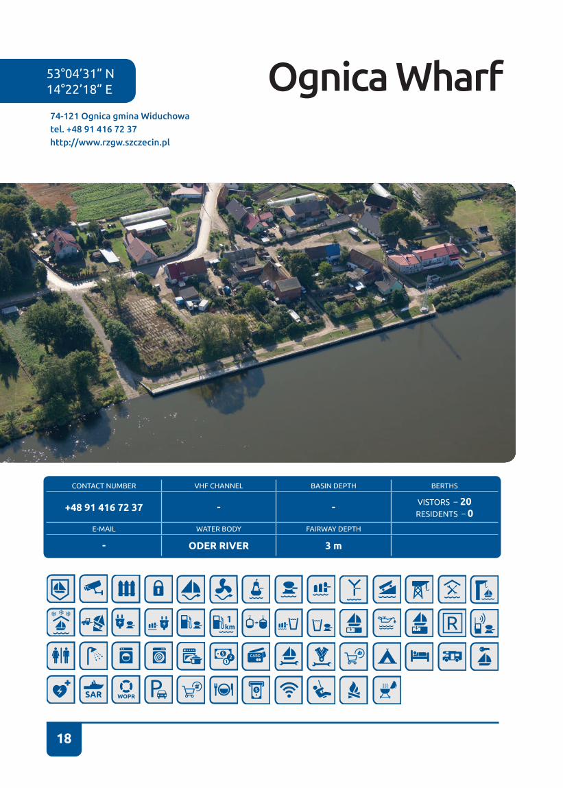
74-121 Ognica gmina Widuchowatel. +48 91 416 72 37http://www.rzgw.szczecin.pl
53°04’31” N14°22’18” E Ognica Wharf

19
OgnicaNear the village of Ognica the water lane leading up the Oder branches out towards the west in the direction of the entry into the Schwedter Querfahrt Canal. The canal links the western and eastern Oder channel and it is the first section of the approach to an industrial town of Schwedt/Oder�
The wharf is located on eastern bank of the Oder� One can approach the wharf directly from the water lane� Owing to waves stirred by barges, pushers and tug boats passing with the main current, yachts should be carefully moored and the proper use of dolphin fenders is particularly recommended� During manoeuvres one need to account for the current whose speed may reach even up to two knots.
It is a place for a short stopover� We will find 20 berthing places there. The facility has no specific tourist and sailing infrastructure� We can berth here is only permitted if no cargo-carrying vessels moor there at the time, which are given privileged use of the wharf on account of its intended purpose� The facility has no specific tourist and sailing infrastructure.
It is recommended that even during a short stopover one person should stay on-board a yacht to be able to move the yacht to a different location in order to vacate the quay for large vessels. If there is free space available, mooring next to the slip in the northern part of the wharf is best� Yachts of greater draught must watch out for the underwater part of the slip ramp�
There is a 15th-century church of Saint Hedwig of Silesia in Ognica village� There is also a small wooden chapel dating back to the early 20th century, which the village residents used after the II World War, when the church in Ognica had been destroyed�
On behalf of the terrain owner – the State Treasury – the Regional Board of Water Management in Szczecin acts as the Administrator of Water Supervision in Ognica�
Odra
3
3
3
UL. OGNICA
Gatow
53°5'
Ognica
Widuchowa

20
CONTACT NUMBER VHF CHANNEL BASIN DEPTH BERTHS
+ 48 91 416 72 37 - - VISTORS – 8RESIDENTS – 0
E-MAIL WATER BODY FAIRWAY DEPTH
- ODER RIVER 3 m
74-120 Widuchowa, ul. Bulwary Rybackietel. + 48 91 416 72 37http://www.rzgw.szczecin.pl
53°07’30” N14°23’12” E Widuchowa Wharf
21
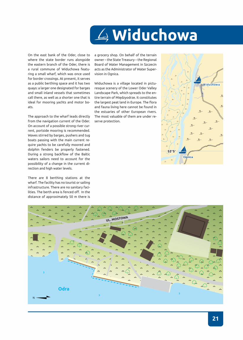
WiduchowaOn the east bank of the Oder, close to where the state border runs alongside the eastern branch of the Oder, there is a rural commune of Widuchowa featu-ring a small wharf, which was once used for border crossings� At present, it serves as a public berthing space and it has two quays: a larger one designated for barges and small inland vessels that sometimes call there, as well as a shorter one that is ideal for mooring yachts and motor bo-ats�
The approach to the wharf leads directly from the navigation current of the Oder� On account of a possible strong river cur-rent, portside mooring is recommended� Waves stirred by barges, pushers and tug boats passing with the main current re-quire yachts to be carefully moored and dolphin fenders be properly fastened� During a strong backflow of the Baltic waters sailors need to account for the possibility of a change in the current di-rection and high water levels�
There are 8 berthing stations at the wharf� The facility has no tourist or sailing infrastructure� There are no sanitary faci-lities. The berth area is fenced off. In the distance of approximately 50 m there is
a grocery shop� On behalf of the terrain owner – the State Treasury – the Regional Board of Water Management in Szczecin acts as the Administrator of Water Super-vision in Ognica�
Widuchowa is a village located in pictu-resque scenery of the Lower Oder Valley Landscape Park, which spreads to the en-tire terrain of Międzyodrze. It constitutes the largest peat land in Europe. The flora and fauna living here cannot be found in the estuaries of other European rivers. The most valuable of them are under re-serve protection�
UL. MOSTOWA
Odra
3
33
Gatow
53°5'
Ognica
Widuchowa
22
53°15’ N 14°29’ E
CONTACT NUMBER VHF CHANNEL BASIN DEPTH BERTHS
+48 607 529 643 - BASIN I – 4 m BASIN II – 4 m
VISITORS – 40RESIDENTS – 20
E-MAIL WATER BODY FAIRWAY DEPTH
- EASTERN ODER 6 m
74-100 Gryfino, ul. Nadodrzańska 1tel. +48 91 416 30 11e-mail: [email protected]://www.osir-gryfino.pl
Town Wharf
23
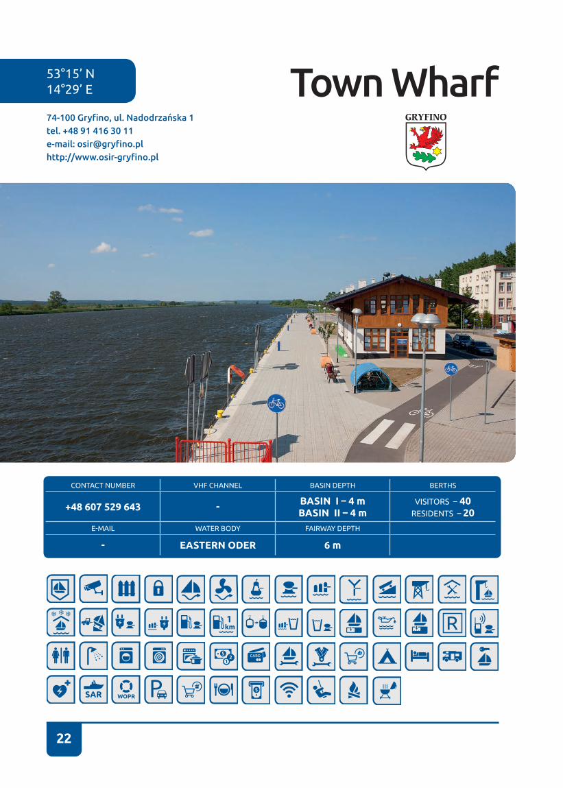
The marina is located on the left-hand side of the Oder, sailing from the direction of Szczecin� Before a bridge there is a wharf that can accept passenger ships� The wharf is equipped with infrastructure permitting the collection of liquid waste� Toilets are available in a tourist information building�
Past the bridge there is a wharf designated for sailing and motor boats� Caution: passage under the bridge directly alongside the shore is forbidden owing to stone reinforcement of a pillar laid on the shore� Behind the bridge there is a floating landing, water and electrical power connections, boatswain’s office with a kitchen and sanitary facilities. The marina is open to visitors, but the boatswain is on duty during the day only� The marina has CCTV surveillance and marina support services - boatswain – are on duty only during the day�
You can rent a paddle boat at the marina, or kayaks at a small harbour on the Tywia River run by the Sports and Recreation Centre (ul. Łużycka 76), which also has a small crane with a lifting capacity of approx. 1000 kg. The marina
is located behind a Lidl store, which can be reached via a concrete slab road�
Gryfino is a small town lying on the Oder. Gryfino boasts “Laguna” water park, which is highly popular among Szczecin residents (approx. 30 km away). Next to the water park there are football pitches and tennis courts� On the other side of the bridge, opposite the marina, there is an attractive playground for children�
At the turn of February and March, “Włóczykij” Gryfino Festival of Locations and Trips is held� At the beginning of May a series of events under the name of Gryfino Days is organized.
Gryfino
UL
. PIA
STÓW
UL. NADODRZAŃSKA
UL
. 1 MA
JA
UL
. TAD
EU
SZA
KO
ŚCIU
SZK
I
UL. B
AŁT
YC
KA
UL. ENERGETYKÓW
4
4
4
4
4
Odra
Żarczyn
Babinek
2 Pniewo
Krajnik
Żurawki
Gryfino
14°30'
24
CONTACT NUMBER VHF CHANNEL BASIN DEPTH BERTHS
+48 599 924 222 65BASIN I – 2,75 m BASIN II – 2,25 mBASIN III - 1,50 m
VISTORS - 40RESIDENTS - 33
E-MAIL WATER BODY FAIRWAY DEPTH
- ODER RIVER 6 m
53°25’05” N14°34’02” E
71-655 Szczecin, ul. Zbożowa /Wendy tel. +48 91 434 70 02e-mail: [email protected]://www.zegluga.szn.pl
Yacht Port in Szczecin Żegluga Szczecińska Sp. z o.o.
25
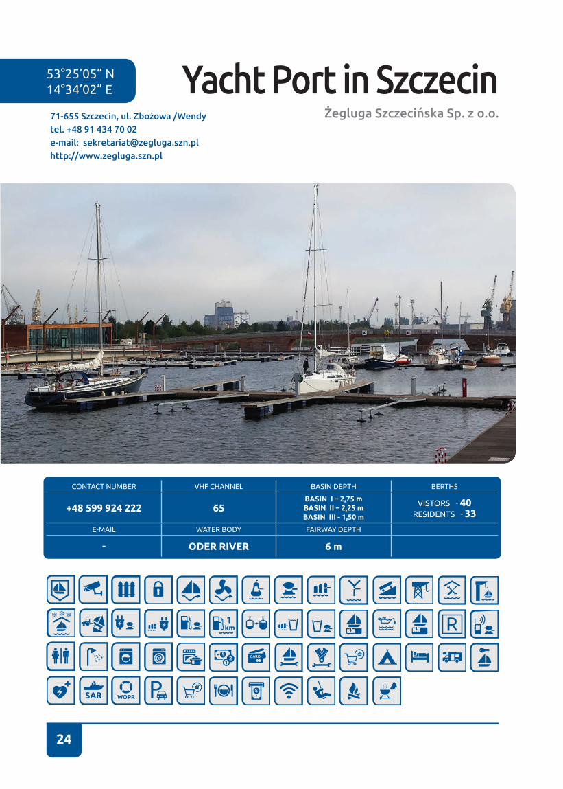
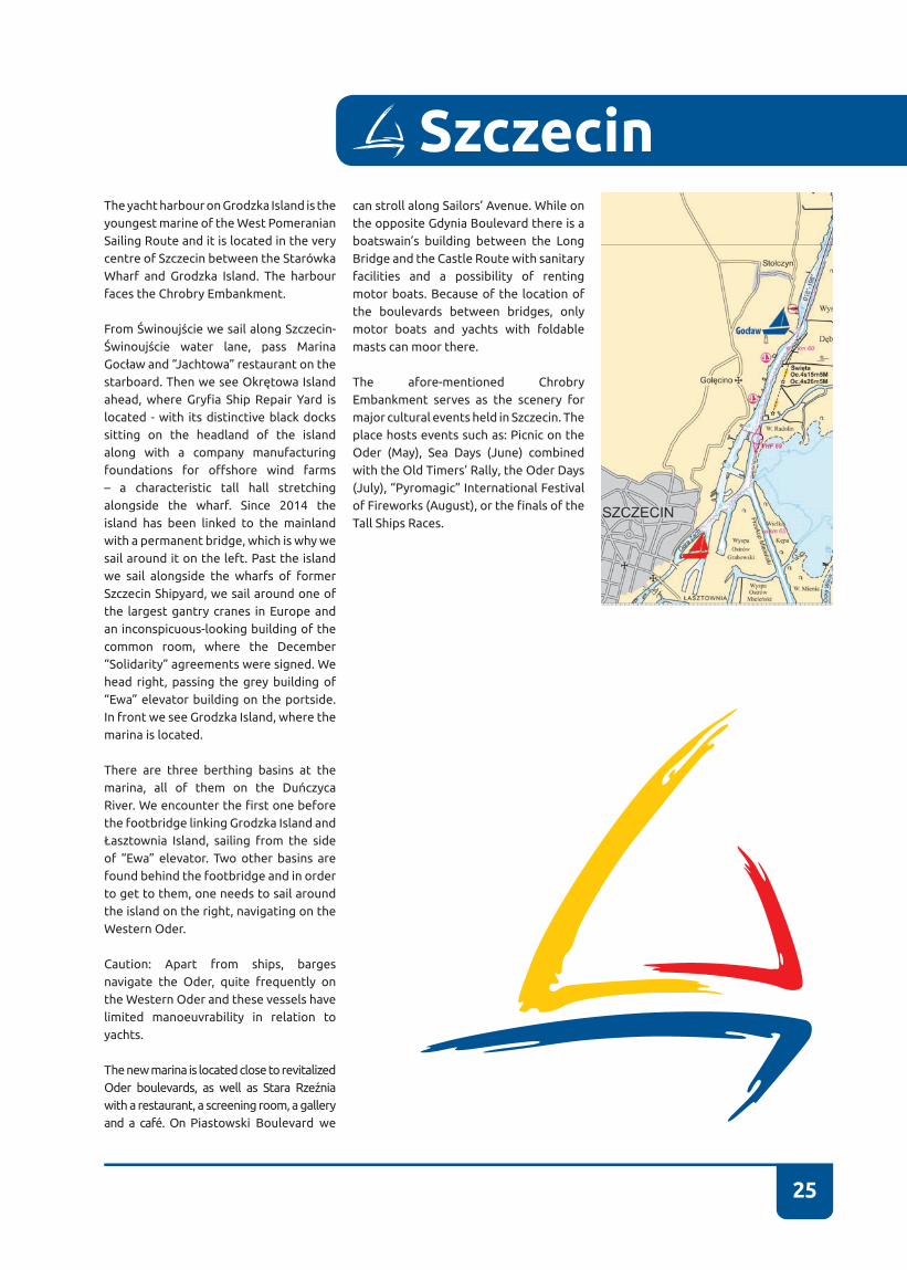
SzczecinThe yacht harbour on Grodzka Island is the youngest marine of the West Pomeranian Sailing Route and it is located in the very centre of Szczecin between the Starówka Wharf and Grodzka Island. The harbour faces the Chrobry Embankment.
From Świnoujście we sail along Szczecin-Świnoujście water lane, pass Marina Gocław and “Jachtowa” restaurant on the starboard. Then we see Okrętowa Island ahead, where Gryfia Ship Repair Yard is located - with its distinctive black docks sitting on the headland of the island along with a company manufacturing foundations for offshore wind farms – a characteristic tall hall stretching alongside the wharf� Since 2014 the island has been linked to the mainland with a permanent bridge, which is why we sail around it on the left� Past the island we sail alongside the wharfs of former Szczecin Shipyard, we sail around one of the largest gantry cranes in Europe and an inconspicuous-looking building of the common room, where the December “Solidarity” agreements were signed. We head right, passing the grey building of “Ewa” elevator building on the portside. In front we see Grodzka Island, where the marina is located�
There are three berthing basins at the marina, all of them on the Duńczyca River. We encounter the first one before the footbridge linking Grodzka Island and Łasztownia Island, sailing from the side of “Ewa” elevator. Two other basins are found behind the footbridge and in order to get to them, one needs to sail around the island on the right, navigating on the Western Oder�
Caution: Apart from ships, barges navigate the Oder, quite frequently on the Western Oder and these vessels have limited manoeuvrability in relation to yachts�
The new marina is located close to revitalized Oder boulevards, as well as Stara Rzeźnia with a restaurant, a screening room, a gallery and a café. On Piastowski Boulevard we
can stroll along Sailors’ Avenue� While on the opposite Gdynia Boulevard there is a boatswain’s building between the Long Bridge and the Castle Route with sanitary facilities and a possibility of renting motor boats� Because of the location of the boulevards between bridges, only motor boats and yachts with foldable masts can moor there�
The afore-mentioned Chrobry Embankment serves as the scenery for major cultural events held in Szczecin. The place hosts events such as: Picnic on the Oder (May), Sea Days (June) combined with the Old Timers’ Rally, the Oder Days (July), “Pyromagic” International Festival of Fireworks (August), or the finals of the Tall Ships Races�
26
CONTACT NUMBER VHF CHANNEL BASIN DEPTH BERTHS
+48 730 023 666+48 530 611 555 - 2,2-4,5 m VISTORS – 30
RESIDENTS – 30E-MAIL WATER BODY FAIRWAY DEPTH
- ODER RIVER 8 m
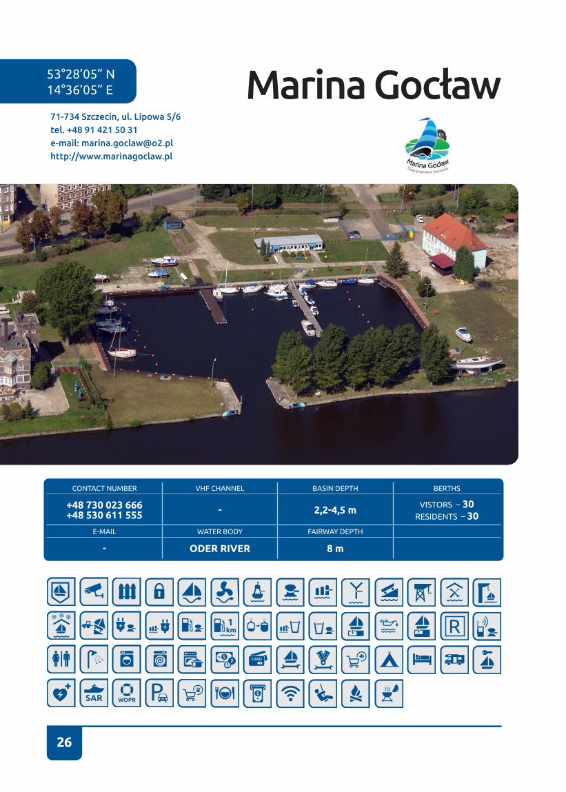
71-734 Szczecin, ul. Lipowa 5/6tel. +48 91 421 50 31e-mail: [email protected]://www.marinagoclaw.pl
53°28’05” N14°36’05” E Marina Gocław
27
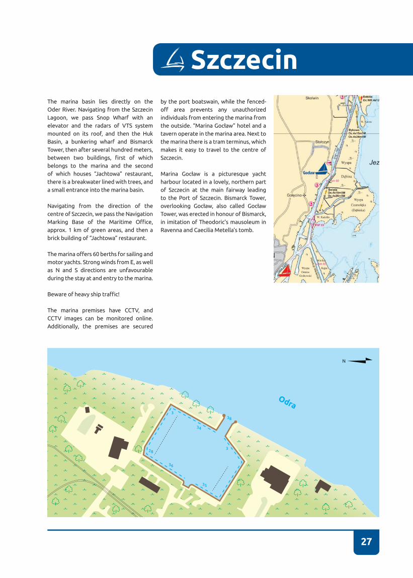
SzczecinThe marina basin lies directly on the Oder River� Navigating from the Szczecin Lagoon, we pass Snop Wharf with an elevator and the radars of VTS system mounted on its roof, and then the Huk Basin, a bunkering wharf and Bismarck Tower, then after several hundred meters, between two buildings, first of which belongs to the marina and the second of which houses “Jachtowa” restaurant, there is a breakwater lined with trees, and a small entrance into the marina basin�
Navigating from the direction of the centre of Szczecin, we pass the Navigation Marking Base of the Maritime Office, approx. 1 km of green areas, and then a brick building of “Jachtowa” restaurant.
The marina offers 60 berths for sailing and motor yachts. Strong winds from E, as well as N and S directions are unfavourable during the stay at and entry to the marina�
Beware of heavy ship traffic!
The marina premises have CCTV, and CCTV images can be monitored online� Additionally, the premises are secured
by the port boatswain, while the fenced-off area prevents any unauthorized individuals from entering the marina from the outside. “Marina Gocław” hotel and a tavern operate in the marina area� Next to the marina there is a tram terminus, which makes it easy to travel to the centre of Szczecin�
Marina Gocław is a picturesque yacht harbour located in a lovely, northern part of Szczecin at the main fairway leading to the Port of Szczecin. Bismarck Tower, overlooking Gocław, also called Gocław Tower, was erected in honour of Bismarck, in imitation of Theodoric’s mausoleum in Ravenna and Caecilia Metella’s tomb�
38
34
35
36
28
3
3
Odra

28
CONTACT NUMBER VHF CHANNEL BASIN DEPTH BERTHS
BOATSWAIN +48 725 495 280 -
I - 2,5 m, II - 2,5 m, III - 2,5 m, IV - 2,5 m
VISITORS – 10RESIDENTS – 200
E-MAIL WATER BODY FAIRWAY DEPTH
- DĄBIE MAŁE LAKE 2,9 m
70-800 Szczecin, ul. Przestrzenna 21tel. +48 91 460 08 44e-mail: [email protected]://www.centrumzeglarskie.pl
53°23’44” N14°38’08” E Sailing Centre
Pałac Młodzieży

29
SzczecinThe Sailing Centre is located in the southern part of Dąbie Małe Lake. The marina abuts Camping Marina and it has two parts: an older one located on the left (looking from the water) and a newer part on the right� An old name – Youth Palace marina – still functions in the sailing community�
Two entrances lead to the marina – the first one is on the left, straight in front of a gantry crane and a small semi-circular hangar, the second one is in between external landings� The marina permits alongside mooring, mooring to Y-booms and to piles� A gantry crane operates in the marina and there are two slipways there� On approach to the shore, especially at weekends and during summer holiday season, watch out for exercising youth�
Winds from N directions are unfavourable during the stay at the marina�
Bakista store for sailors is located next to the marina� Water Police units are stationed in the marina� Next to the marina there are bus stops of services running to Szczecin and Szczecin-Dąbie.
The centre is one of the largest training centres for young generation of sailors in Szczecin� It propagates water tourism and sailing among children and youth� It is an educational institution of the City of Szczein, the only such a facility in all of Poland. The Centre offers classes to children and youth all the year round in several sections – tourist, regatta, kayaks. It also organizes tourist cruises, camps and bivouacs, canoeing, windsurfing, integration events, Nordic walking, kayak rental, courses and training for various sailing qualifications. The harbour offers a room for conferences, training sessions, which features a sound system and multimedia equipment. It is also possible to organize outdoor events�
The centre is a ship owner of some distinguished vessels; inter alia “Dar Młodzieży”, which won the Tall Ships Races in its class on several occasions, and of a 50-year-old “Magnolia”.
Lubicz
Krzywin
Bolkowice
Kłodowo
Krzywin Kolonia
Krzywinek
Lubiczyn
Map data © OpenStreetMap contributors
87
5
3
3
1
1
1
3
1
4 4
22

30
CONTACT NUMBER VHF CHANNEL BASIN DEPTH BERTHS
+48 600 225 204 - 2,5 m VISITORS – 10RESIDENTS – 60
E-MAIL WATER BODY FAIRWAY DEPTH
[email protected] DĄBIE MAŁE LAKE 2,5 m
53°23’49” N14°38’26” E
70-800 Szczecin, ul. Przestrzenna 23tel. +48 91 460 11 65e-mail: [email protected]://www.campingmarina.pl
Camping Marina PTTK
31
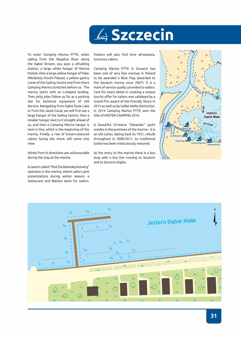
SzczecinTo enter Camping Marina PTTK, when sailing from the Regalica River along the Dąbie Stream, you pass a refuelling station, a large white hangar of Marina Hotele, then a large yellow hangar of Pałac Młodzieży (Youth Palace), a yellow gantry crane of the Sailing Centre and from there Camping Marina stretches before us� The marina starts with an L-shaped landing� Then jetty piles follow as far as a parking site for technical equipment of UW Service. Navigating from Dąbie Duże Lake or from the Jacek Canal, we will first see a large hangar of the Sailing Centre, then a smaller hangar next to it straight ahead of us, and then a Camping Marina hangar is next in line, which is the beginning of the marina� Finally, a row of brown-coloured cabins facing the shore will come into view�
Winds from N directions are unfavourable during the stay at the marina�
A tavern called “Pod Zardzewiałą Kotwicą” operates in the marina, where sailors give presentations during winter season, a restaurant and Bakista store for sailors.
Visitors will also find here all-seasons, luxurious cabins�
Camping Marina PTTK in Szczecin has been one of very few marinas in Poland to be awarded a Blue Flag (awarded to the Szczecin marina since 2007)� It is a mark of service quality provided to sailors. Care for every detail in creating a unique tourist offer for sailors was validated by a Grand Prix award of the Friendly Shore in 2013 as well as by Gelbe Welle distinction� In 2014 Camping Marina PTTK won the title of MISTER CAMPING 2014.
A beautiful 23-metre “Oleander” yacht resides in the premises of the marina – it is an old cutter, dating back to 1931, rebuilt throughout in 2008-2011, its traditional tackle has been meticulously restored.
At the entry to the marina there is a bus stop with a bus line running to Szczecin and to Szczecin-Dąbie.
Lubicz
Krzywin
Bolkowice
Kłodowo
Krzywin Kolonia
Krzywinek
Lubiczyn
Map data © OpenStreetMap contributors
87
5
3
3
1
1
1
3
1
4 4
22

32
CONTACT NUMBER VHF CHANNEL BASIN DEPTH BERTHS
+48 605 400 189 - 2,5 m VISTORS – 10RESIDENTS – 90
E-MAIL WATER BODY FAIRWAY DEPTH
- DĄBIE MAŁE LAKE 3 m
70-832 Szczecin, ul. Żaglowa 2tel. +48 91 460 08 52e-mail: [email protected]://www.homszczecin.pl
53°24’10” N14°39’59” E Scouts’ Maritime Centre

33
SzczecinZA buoy-marked water lane leads to the marina from the Jacek Canal. From a distan-ce you should steer towards the buildings of an old elevator, or a church� The entran-ce to the SMC is located behind some trees on the right� Directly ahead of you will see a canal of a former elevator, on the portsi-de you will find the Maritime League canal. On both sides of the water lane there are shoals� When travelling on-board a yacht with greater draught, you should moor on the right-hand side of the SMC’s basin� On the left-hand side the basin is very shallow� Owing to very dense positioning of yachts in the basin, entering the marina under sails is impossible� On the right of the en-trance towards the water lane a sandbank appears temporarily. Due to lack of lighting alongside the water lane and on account of fishing nets, entering the SMC’s marina is not recommended at night�
The Scouts’ Maritime Centre is a harbour in which many local sailors started their sailing careers, navigating Vega, Totem and Watra yachts, among other vessels� It is worth mentioning that the idea of sea cru-ises on-board DZ yachts started in the SMC. Piotr Czeronko won the award of the Cru-
ise of the Year for his yacht cruise on-board “Żagiewka” (Nefryt) around the Baltic Sea.
SMC offers charter yachts or kayaks rental service� Nearby the SMC there is a well--outfitted town beach, where each year Lake Dąbie Film Evenings take place in late--July. In Szczecin Dąbie, located 1 km away from the SMC, you will find shops, an ATM, as well as a shopping centre, including a 24-hour Społem supermarket. In Dąbie itself we recommend that you visit the church of Virgin Mary’s Immaculate Conception with a very distinctive-looking tower as well as Dąbie’s historic area on the Płonia River (presently areas designated for leisure and walking).
Interestingly, during the 1960’s “Kormo-ran” yachts and during the 1970’s “Wydra” yachts were built in a boat building shop located in the centre premises� A small ma-nor house built around 1917 is located in the centre area� Before the war it used to be the Bochertow’s residence� The manor house was connected to a lovely garden� Today the manor house is under repair�
Jezioro Dąbie Małe
3
3
3
25
25
34
CONTACT NUMBER VHF CHANNEL BASIN DEPTH BERTHS
+48 91 461 27 34+48 600 233 221 - 6-1 m VISTORS – 10
RESIDENTS – 130E-MAIL WATER BODY FAIRWAY DEPTH
[email protected] DĄBIE MAŁE LAKE 2,4 m
70-800 Szczecin, ul. Przestrzenna 9tel. +48 91 461 27 34e-mail: [email protected]://www.jkazs.szn.pl
53°23’52” N14°37’30” E AZS Yacht Club
Jacht Klub Akademickiego Związku Sportowego w Szczecinie
35
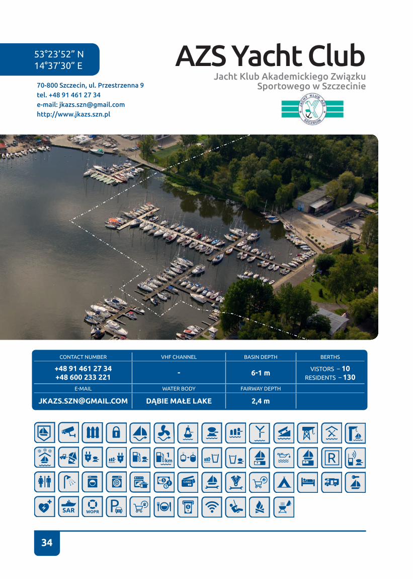
SzczecinAZS Yacht Club is located on Dąbie Małe Lake. It lies in a quiet cove, which can be accessed from the side of the Dąbie Stream and from Dąbie Małe Lake. The marina premises start immediately past Marina Hotele, approximately in the vicinity of the boatswain’s office, and it ends directly next to a hangar� The marina has the character of a club, hence most berths are occupied by club members�
Strong winds from E and N directions are unfavourable during the stay at and entry to the marina�
A tavern - well-known among sailors - is located in the marina premises� AST SAILS - a sail-making shop as well as a boat-building shop operate in the marina. AZS Yacht Club has been organizing sailing activities for children, youth and students of Szczecin universities for years. Ludomir Mączka and Kazimierz Haska were one of many sailors associated with the club�
Yacht Club of the Academic Sports Association (AZS) is one of the oldest and most distinguished sailing clubs in Szczecin�
It was founded on 12 November 1946 and originally it existed as a Sailing Section of the Academic Sports Association at Szczecin branch of the Academy of Economics in Poznań. The first section manager was the Academy’s student – Feliks Wodziński.
AZS Yacht Club is the ship owner of “Stary” yacht, which was the first one among Polish yachts to have completed the north-western crossing, i.e. a route from Europe to East Asia, running through the waters of the Arctic Archipelago�
The club web site provides an interesting record of the history of Szczecin-based (and not only) sailing. AZS is one of few sailing clubs maintaining an organized history of its operations, dating back to 1946� Currently there are approx� 100 yachts of various types registered in the club, the best known are: one-hundred-year-old Nadir yacht, handed over in 1949 by the headmaster of the Maritime School in Szczecin, Konstanty Maciejewicz.
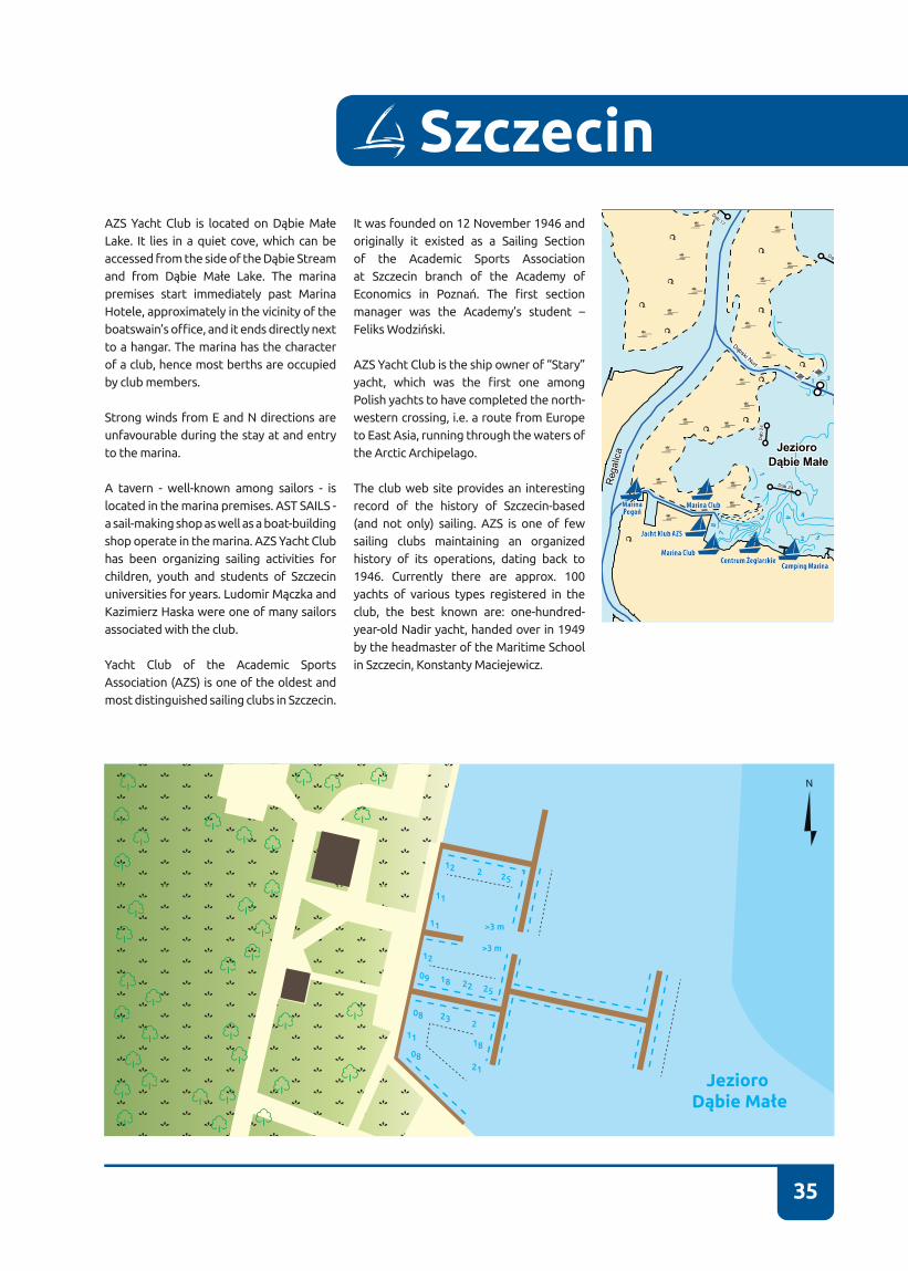
Jezioro Dąbie Małe
1225
>3 m
>3 m
2522
21
23 2
2
12
09
08
08
18
18
11
11
11
Lubicz
Krzywin
Bolkowice
Kłodowo
Krzywin Kolonia
Krzywinek
Lubiczyn
Map data © OpenStreetMap contributors
87
5
3
3
1
1
1
3
1
4 4
22
36
CONTACT NUMBER VHF CHANNEL BASIN DEPTH BERTHS
+ 48 601 984 897 MARINA MANAGER
+ 48 91 461 43 5977 I - 3 m, II - 3 m VISTORS – 15
RESIDENTS – 90
E-MAIL WATER BODY FAIRWAY DEPTH
[email protected] DĄBIE MAŁE LAKE 3,2 m
70-800 Szczecin, ul. Przestrzenna 7 i 11kom.: +48 609 112 479e-mail: [email protected]://www.marina-club.pl
53°23’54” N14°37’32” E Marina Club
37
Szczecin
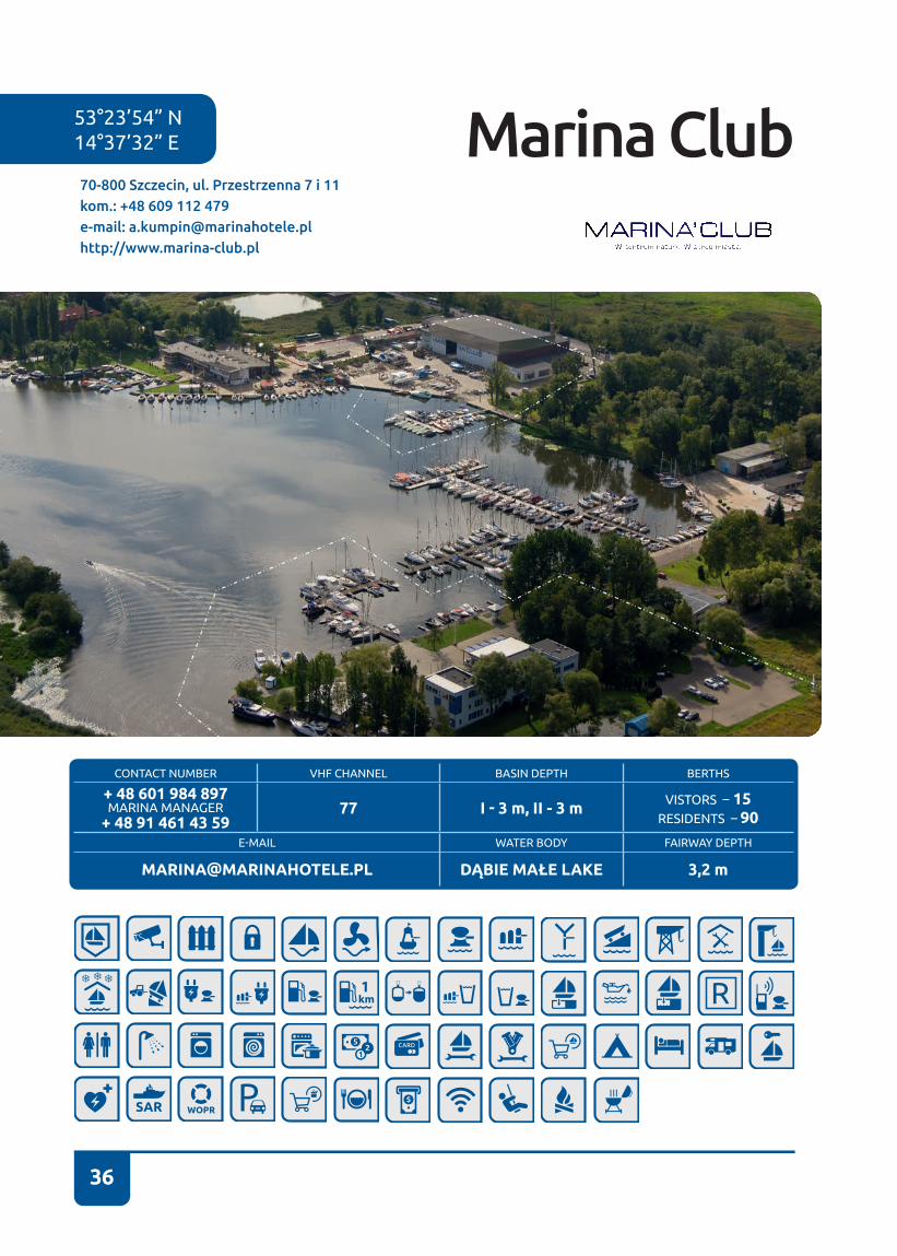
You can approach Marina Club from the side of the Dąbie Stream and from the side of Dąbie Małe Lake – the basin starts directly next to a refuelling station and it abuts AZS quay. In front of the basin there is a two-floor hotel and a restaurant building. Y-booms are permanently attached to a concrete quay.
A second, smaller quay is situated near the building of a large hangar of a former hydroplane base, located almost in the middle of the southern shore of the bay� This is also where a slipway for launching smaller vessels from boat-carrying trailers is located� Next to the hangar there is a seat of Yacht Club Polska, Maritime Shop, engine servicing shops, a store with yacht paints and chemicals as well as a sports centre, comprised of 6 professional squash and ricochet courses, 2 full-sized badminton courts, 6 table tennis tables, a rock climbing wall, among other facilities.
Marina Club is able to accommodate approx. 90 yachts at both its quays. Maximum draught in the marina is 3�5 m� A cargo boom with a lifting capacity of about 1000 kg is available, facilitating any work with yacht masts.
Both of the marina quays are well protected from waves, which allows for a comfortable stay at the marina�
Strong winds from N directions are unfavourable during the stay at and entry to the Marina Club�
It is undoubtedly the most luxurious, well-protected marina in Szczecin�
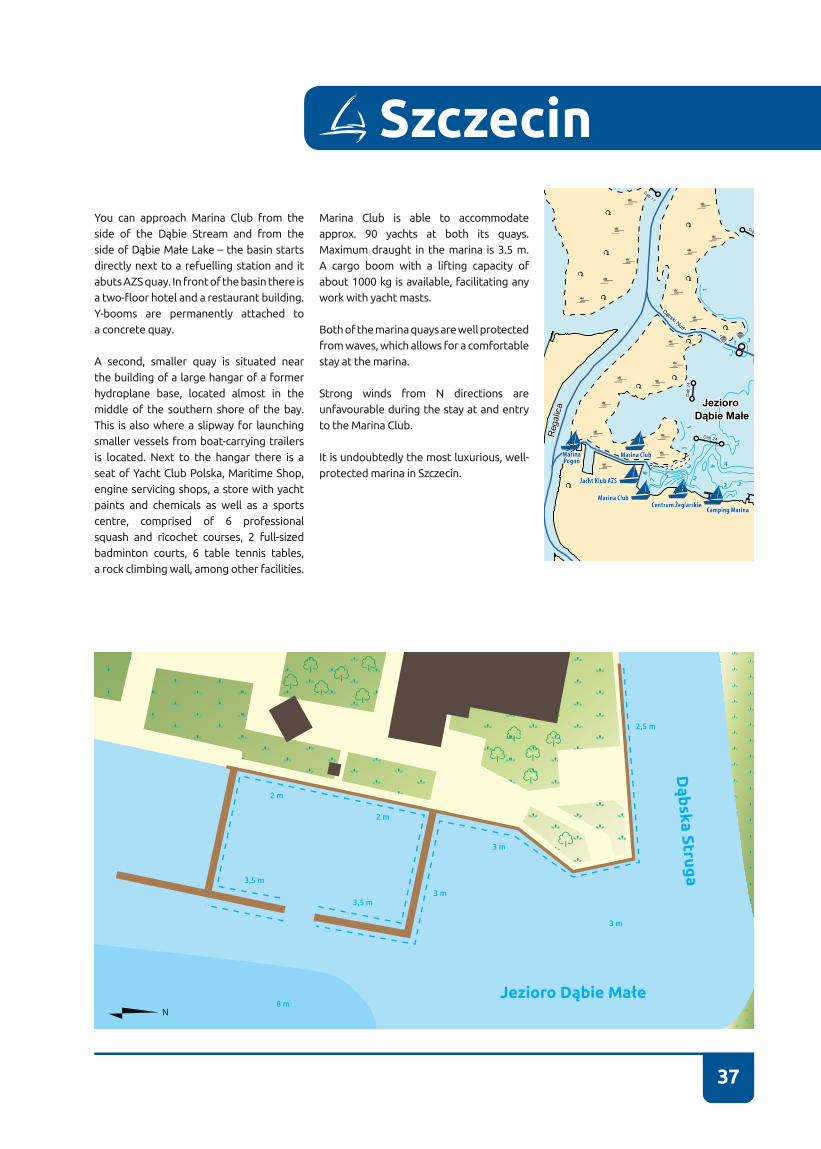
2,5 m
3 m
8 m
3 m3,5 m
2 m
2 m
3,5 m
3 m
Dąb
ska Struga
Jezioro Dąbie Małe
Lubicz
Krzywin
Bolkowice
Kłodowo
Krzywin Kolonia
Krzywinek
Lubiczyn
Map data © OpenStreetMap contributors
87
5
3
3
1
1
1
3
1
4 4
22
53°24’00” N14°37’20” E
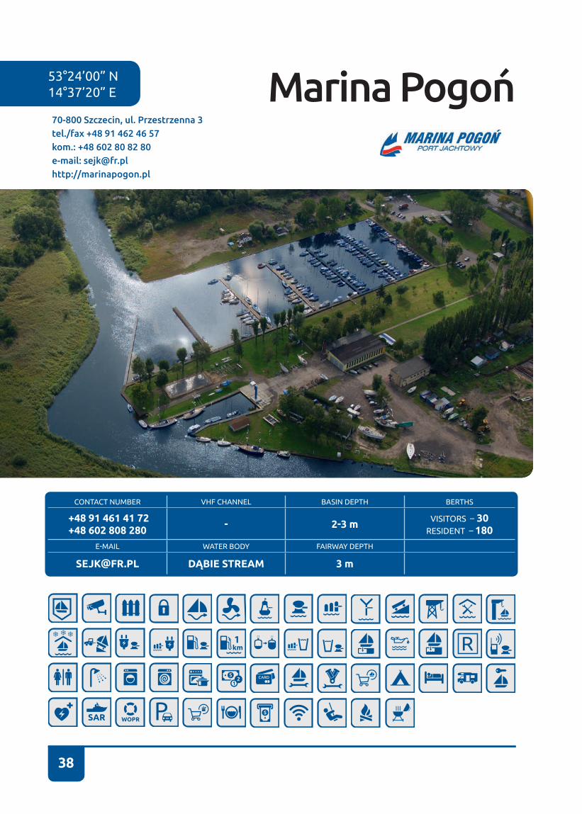
38
Marina Pogoń
CONTACT NUMBER VHF CHANNEL BASIN DEPTH BERTHS
+48 91 461 41 72 +48 602 808 280 - 2-3 m VISITORS – 30
RESIDENT – 180E-MAIL WATER BODY FAIRWAY DEPTH
[email protected] DĄBIE STREAM 3 m
70-800 Szczecin, ul. Przestrzenna 3tel./fax +48 91 462 46 57kom.: +48 602 80 82 80e-mail: [email protected]://marinapogon.pl
38
39
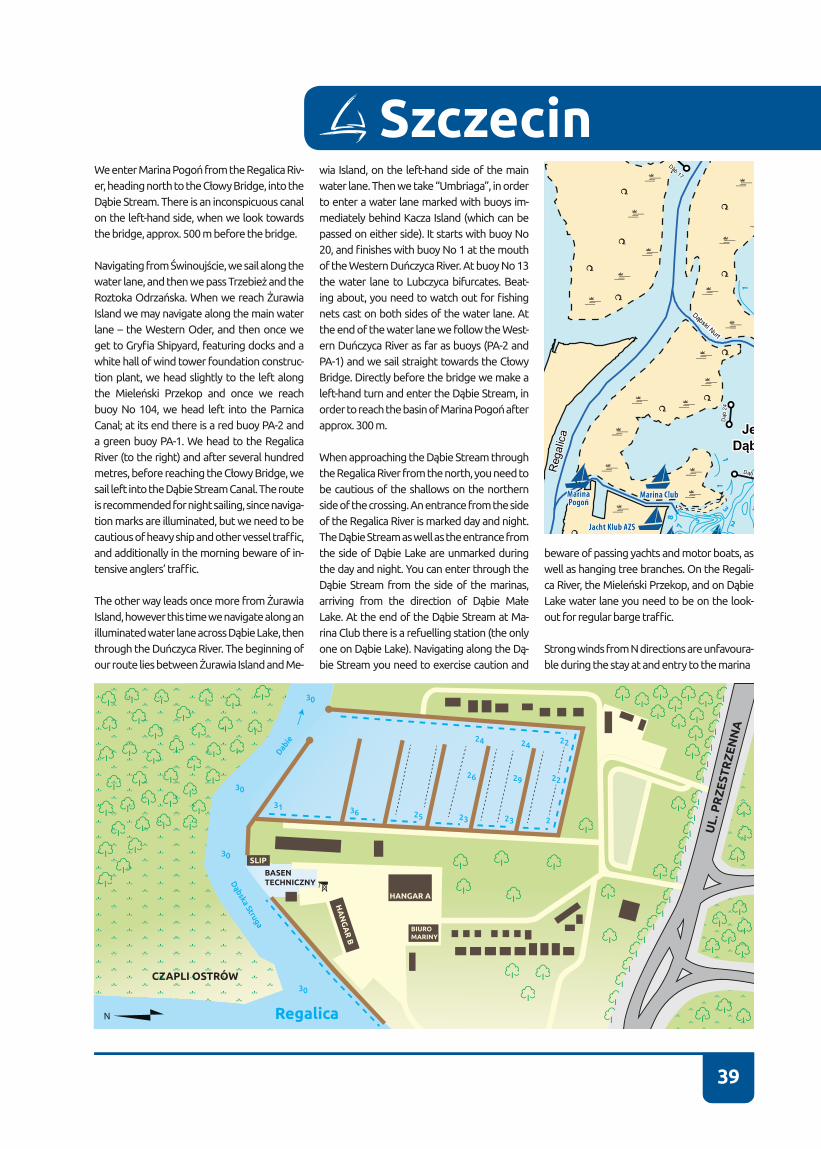
SzczecinWe enter Marina Pogoń from the Regalica Riv-er, heading north to the Cłowy Bridge, into the Dąbie Stream. There is an inconspicuous canal on the left-hand side, when we look towards the bridge, approx� 500 m before the bridge�
Navigating from Świnoujście, we sail along the water lane, and then we pass Trzebież and the Roztoka Odrzańska. When we reach Żurawia Island we may navigate along the main water lane – the Western Oder, and then once we get to Gryfia Shipyard, featuring docks and a white hall of wind tower foundation construc-tion plant, we head slightly to the left along the Mieleński Przekop and once we reach buoy No 104, we head left into the Parnica Canal; at its end there is a red buoy PA-2 and a green buoy PA-1� We head to the Regalica River (to the right) and after several hundred metres, before reaching the Cłowy Bridge, we sail left into the Dąbie Stream Canal. The route is recommended for night sailing, since naviga-tion marks are illuminated, but we need to be cautious of heavy ship and other vessel traffic, and additionally in the morning beware of in-tensive anglers’ traffic.
The other way leads once more from Żurawia Island, however this time we navigate along an illuminated water lane across Dąbie Lake, then through the Duńczyca River. The beginning of our route lies between Żurawia Island and Me-
wia Island, on the left-hand side of the main water lane. Then we take “Umbriaga”, in order to enter a water lane marked with buoys im-mediately behind Kacza Island (which can be passed on either side)� It starts with buoy No 20, and finishes with buoy No 1 at the mouth of the Western Duńczyca River. At buoy No 13 the water lane to Lubczyca bifurcates� Beat-ing about, you need to watch out for fishing nets cast on both sides of the water lane� At the end of the water lane we follow the West-ern Duńczyca River as far as buoys (PA-2 and PA-1) and we sail straight towards the Cłowy Bridge. Directly before the bridge we make a left-hand turn and enter the Dąbie Stream, in order to reach the basin of Marina Pogoń after approx� 300 m�
When approaching the Dąbie Stream through the Regalica River from the north, you need to be cautious of the shallows on the northern side of the crossing� An entrance from the side of the Regalica River is marked day and night. The Dąbie Stream as well as the entrance from the side of Dąbie Lake are unmarked during the day and night� You can enter through the Dąbie Stream from the side of the marinas, arriving from the direction of Dąbie Małe Lake. At the end of the Dąbie Stream at Ma-rina Club there is a refuelling station (the only one on Dąbie Lake). Navigating along the Dą-bie Stream you need to exercise caution and
beware of passing yachts and motor boats, as well as hanging tree branches� On the Regali-ca River, the Mieleński Przekop, and on Dąbie Lake water lane you need to be on the look-out for regular barge traffic.
Strong winds from N directions are unfavoura-ble during the stay at and entry to the marina
39
Lubicz
Krzywin
Bolkowice
Kłodowo
Krzywin Kolonia
Krzywinek
Lubiczyn
Map data © OpenStreetMap contributors
87
5
3
3
1
1
1
3
1
4 4
22
Dąbska Struga
Regalica
CZAPLI OSTRÓW
31
30
30
30
30
362
22
23
29
2424
26
2325
22
Dabie
BASEN TECHNICZNY
SLIP
UL.
PR
ZEST
RZE
NN
A
BIURO MARINY
HANGAR A
HA
NG
AR
B

40
Marina LubczynaPrzystań Żeglarska Ośrodka
Sportu i Rekreacji w Goleniowie
53°33’00” N 14°42’02” E
72-105 Lubczyna, ul. Żeglarska 2Boatswain’s office: +48 91 419 16 12 Manager: + 48 534 250 305Boatswain: + 48 691 640 765e-mail: [email protected]://www.lubczyna.goleniow.pl
CONTACT NUMBER VHF CHANNEL BASIN DEPTH BERTHS
+48 663 046 498 7716
VISTORS – 2,0-2,5 mSOUTHERN – 2,0 m
VISTORS – 30RESIDENTS – 70
E-MAIL WATER BODY FAIRWAY DEPTH
[email protected] JEZIORO DĄBIE 2,0-2,5 m

41
SzczecinHeading from the main water lane to Dąbie Duże Lake from buoy No 13, we sail along Lubczyna Water Lane marked with buoys L1 to L9 (the last buoy is immediately be-fore the harbour)� The water lane is not lit� We must not deviate outside of the area marked by the buoys. Yachts of greater draught are in particular danger of running aground if they leave the fairway�
The marina has recently undergone signi-ficant extension and some of the old, de-relict buildings have been demolished� The port is divided into two sections. Looking from the water – on the starboard, on the southern side, in the area where the appro-ach fairway ends, there is a double basin shielded by a floating landing, further on to the north there is an old, but moderni-zed basin used chiefly by visiting yachts; it is shielded with a breakwater made of a sunken old barge.
Despite the extension of the harbour and an increase in the number of berthing sta-tions, arriving yachts often find it difficult to find a mooring place. Marina Lubczyna is the only harbour in this part of the lake and traditionally, especially on public holidays,
sailing enthusiasts head there in droves for short yachting outings�
S-SW winds are unfavourable during the stay at and entry to the marina�
A wide, sandy, guarded beach with a slide and water equipment rental is an integral part of marina in Lubczyna� It is possible to hire sailing yachts, including Delphia 37�3, several large Maxus type drop keel yachts as well as recreational equipment. In 2013, the bathing beach was awarded a presti-gious Blue Flag� Next to the beach there are several food outlets and shops�
A canoeing trail – the Ina Meanders – runs from Goleniów to Lubczyna. It is possible to rent kayaks or travel by a water bus on the Ina River�
21
21
21
23
2121
22
22
JezioroDąbie

42
TKKF Olimpia72-010 Police, ul. M.Konopnickiej 20tel./fax +48 91 450 14 92kom.: +48 501 284 538e-mail: [email protected]://www.olimpia.police.pl
53°33’18” N 14°34’26” E
CONTACT NUMBER VHF CHANNEL BASIN DEPTH BERTHS
- - 1,6 m VISITORS – 2RESIDENTS – 31
E-MAIL WATER BODY FAIRWAY DEPTH
- ŁARPIA RIVER 1,5-2,5 m
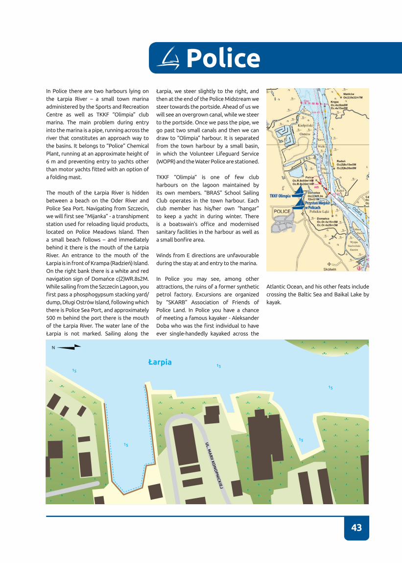
43
In Police there are two harbours lying on the Łarpia River – a small town marina administered by the Sports and Recreation Centre as well as TKKF “Olimpia” club marina� The main problem during entry into the marina is a pipe, running across the river that constitutes an approach way to the basins. It belongs to “Police” Chemical Plant, running at an approximate height of 6 m and preventing entry to yachts other than motor yachts fitted with an option of a folding mast�
The mouth of the Łarpia River is hidden between a beach on the Oder River and Police Sea Port� Navigating from Szczecin, we will first see “Mijanka” - a transhipment station used for reloading liquid products, located on Police Meadows Island� Then a small beach follows – and immediately behind it there is the mouth of the Łarpia River� An entrance to the mouth of the Łarpia is in front of Krampa (Radzień) Island. On the right bank there is a white and red navigation sign of Domańce c(2)WR.8s2M. While sailing from the Szczecin Lagoon, you first pass a phosphogypsum stacking yard/dump, Długi Ostrów Island, following which there is Police Sea Port, and approximately 500 m behind the port there is the mouth of the Łarpia River. The water lane of the Łarpia is not marked. Sailing along the
Łarpia, we steer slightly to the right, and then at the end of the Police Midstream we steer towards the portside� Ahead of us we will see an overgrown canal, while we steer to the portside� Once we pass the pipe, we go past two small canals and then we can draw to “Olimpia” harbour. It is separated from the town harbour by a small basin, in which the Volunteer Lifeguard Service (WOPR) and the Water Police are stationed�
TKKF “Olimpia” is one of few club harbours on the lagoon maintained by its own members. “BRAS” School Sailing Club operates in the town harbour. Each club member has his/her own “hangar” to keep a yacht in during winter. There is a boatswain’s office and modernised sanitary facilities in the harbour as well as a small bonfire area.
Winds from E directions are unfavourable during the stay at and entry to the marina�
In Police you may see, among other attractions, the ruins of a former synthetic petrol factory. Excursions are organized by “SKARB” Association of Friends of Police Land� In Police you have a chance of meeting a famous kayaker - Aleksander Doba who was the first individual to have ever single-handedly kayaked across the
Police
Atlantic Ocean, and his other feats include crossing the Baltic Sea and Baikal Lake by kayak.
Łarpia15
15
15
15
15
UL. M
AR
II KO
NO
PN
ICK
IEJ

44
53°33’17” N 14°34’21” E
72-010 Police, ul. Konopnickiej 12tel. +48 91 317 54 79e-mail: [email protected]://www.osirpolice.pl
CONTACT NUMBER VHF CHANNEL BASIN DEPTH BERTHS
- - 1,6 m 15E-MAIL AWATER BODY FAIRWAY DEPTH
- ŁARPIA RIVER 1,5-2,5 m
Town Harbour in Police

45
In Police there are two harbours lying on the Łarpia River – a small town marina administered by the Sports and Recreation Centre as well as TKKF “Olimpia” club marina. The main problem during entry into the marina is a pipe, running across the river that constitutes an approach way to the basins� It belongs to “Police” Chemical Plant, running at an approximate height of 6 m and preventing entry to yachts other than motor yachts fitted with an option of a folding mast.
“BRAS” School Sailing Club operates in the town harbour; it has newly renovated sanitary facilities and a hangar, as well as a small bonfire area. There is a boatswain’s office and sanitary facilities in the marina.
The mouth of the Łarpia River is hidden between a beach on the Oder River and Police Sea Port� Sailing from the Szczecin Lagoon, you first pass “Mijanka” - a transhipment station used for reloading liquid products (ammonia, sulphuric acid), located on Police Meadows Island, and then a small beach follows – and immediately behind it there is a mouth of the Łarpia River. An entrance to the mouth of the Łarpia
is in front of Krampa (Radzień) Island. On the right bank there is a white and red navigation sign of Domańce c(2)WR�8s2M� Whereas while sailing from the Szczecin Lagoon, you first pass a phosphogypsum stacking yard/dump, Długi Ostrów Island, following which there is Police Sea Port, and approximately 500 m behind the port there is a mouth of the Łarpia River. The water lane of the Łarpia is not marked. Sailing along the Łarpia, we steer slightly to the starboard, and then at the end of the Police Midstream we steer towards the portside� Ahead of us we will see an overgrown canal, while we steer to the portside, and once we pass the pipe, we go past two small canals and then we can draw to the harbour� The town harbour features a small floating platform, a hangar and a building that houses sanitary facilities and offices, as well as a small slipway�
Winds from E directions are unfavourable during the stay at and entry to the marina�
Police
Łarpia15
15
15
15
15
UL. M
AR
II KO
NO
PN
ICK
IEJ

46
53°39’01” N 14°38’00” E
72-112 Stepnica, ul. Rybacka, Młynarskatel./fax +48 91 418 85 21e-mail: [email protected]://www.stepnica.pl
Yacht Harbour on the Młyński Canal
CONTACT NUMBER VHF CHANNEL BASIN DEPTH BERTHS
+48 91 418 85 21 71 2,5 m VISTORS – 300RESIDENTS – 0
E-MAIL WATER BODY FAIRWAY DEPTH
- ROZTOKA ODRZAŃSKA-SZCZECIN LAGOON 2,5 m
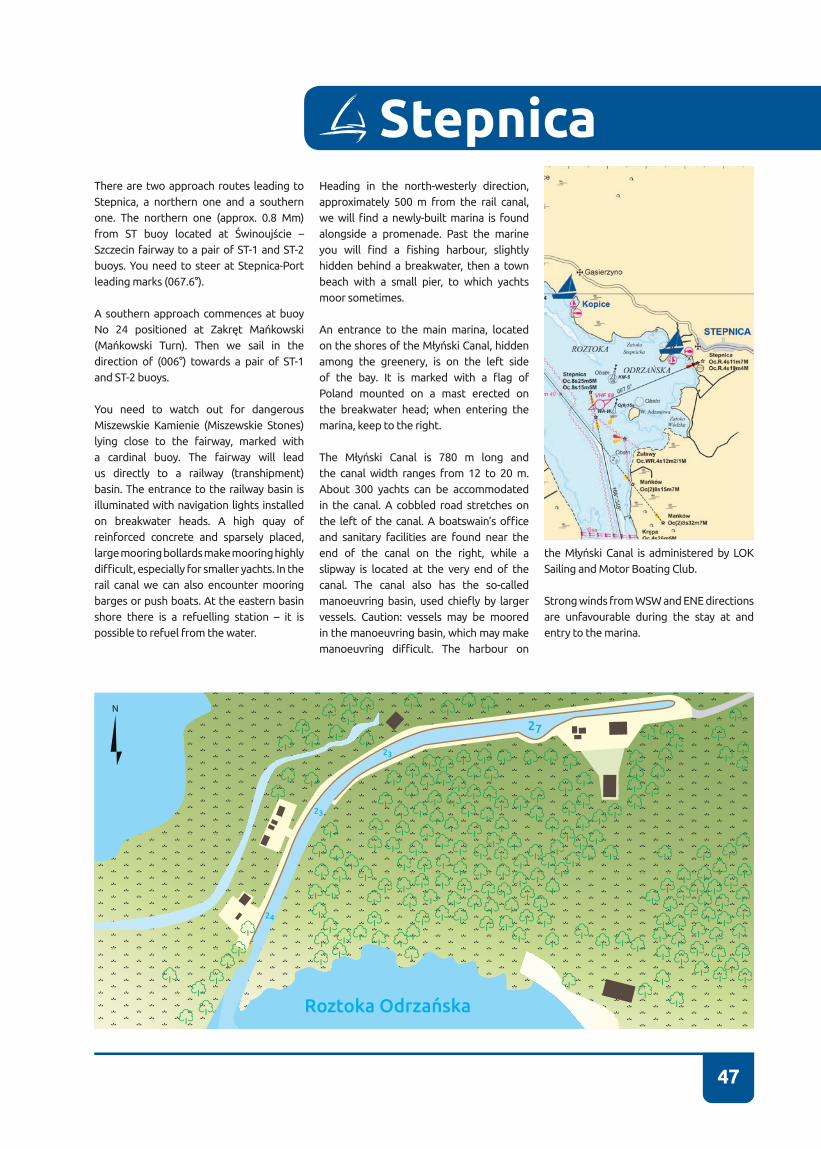
47
There are two approach routes leading to Stepnica, a northern one and a southern one� The northern one (approx� 0�8 Mm) from ST buoy located at Świnoujście – Szczecin fairway to a pair of ST-1 and ST-2 buoys� You need to steer at Stepnica-Port leading marks (067.6°).
A southern approach commences at buoy No 24 positioned at Zakręt Mańkowski (Mańkowski Turn). Then we sail in the direction of (006°) towards a pair of ST-1 and ST-2 buoys�
You need to watch out for dangerous Miszewskie Kamienie (Miszewskie Stones) lying close to the fairway, marked with a cardinal buoy� The fairway will lead us directly to a railway (transhipment) basin� The entrance to the railway basin is illuminated with navigation lights installed on breakwater heads. A high quay of reinforced concrete and sparsely placed, large mooring bollards make mooring highly difficult, especially for smaller yachts. In the rail canal we can also encounter mooring barges or push boats� At the eastern basin shore there is a refuelling station – it is possible to refuel from the water�
Heading in the north-westerly direction, approximately 500 m from the rail canal, we will find a newly-built marina is found alongside a promenade� Past the marine you will find a fishing harbour, slightly hidden behind a breakwater, then a town beach with a small pier, to which yachts moor sometimes�
An entrance to the main marina, located on the shores of the Młyński Canal, hidden among the greenery, is on the left side of the bay. It is marked with a flag of Poland mounted on a mast erected on the breakwater head; when entering the marina, keep to the right.
The Młyński Canal is 780 m long and the canal width ranges from 12 to 20 m� About 300 yachts can be accommodated in the canal� A cobbled road stretches on the left of the canal. A boatswain’s office and sanitary facilities are found near the end of the canal on the right, while a slipway is located at the very end of the canal� The canal also has the so-called manoeuvring basin, used chiefly by larger vessels. Caution: vessels may be moored in the manoeuvring basin, which may make manoeuvring difficult. The harbour on
Stepnica
the Młyński Canal is administered by LOK Sailing and Motor Boating Club�
Strong winds from WSW and ENE directions are unfavourable during the stay at and entry to the marina�
Roztoka Odrzańska
27
23
23
24

48
CONTACT NUMBER VHF CHANNEL BASIN DEPTH BERTHS
- 71 2,5 m VISTORS – 40
E-MAIL WATER BODY FAIRWAY DEPTH
-ROZTOKA ODRZAŃ-
SKA-SZCZECIN LAGOON 2,5 m
72-112 Stepnica, ul. Kościuszkitel. +48 91 418 85 21e-mail: [email protected]://www.stepnica.pl
53°38’59” N14°37’08” E Yacht Harbour in Stepnica Fishing Basin
Sea Fishing Harbour in Stepnica
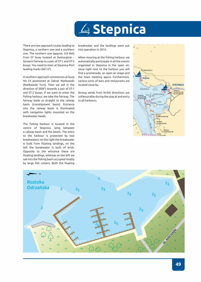
49
There are two approach routes leading to Stepnica, a northern one and a southern one� The northern one (approx� 0�8 Mm) from ST buoy located at Świnoujście – Szczecin fairway to a pair of ST-1 and ST-2 buoys� You need to steer at Stepnica-Port leading marks (067.6°).
A southern approach commences at buoy No 24 positioned at Zakręt Mańkowski (Mańkowski Turn). Then we sail in the direction of (006°) towards a pair of ST-1 and ST-2 buoys� If we want to enter the fishing harbour, we take the fairway. The fairway leads us straight to the railway basin (transhipment basin). Entrance into the railway basin is illuminated with navigation lights mounted on the breakwater heads.
The fishing harbour is located in the centre of Stepnica, lying between a railway basin and the beach� The entry to the harbour is protected by two breakwaters: on the right the breakwater is built from floating landings, on the left the breakwater is built of brick. Opposite to the entrance there are floating landings, whereas on the left we sail into the fishing basin occupied mostly by large fish cutters. Both the floating
breakwater and the landings were put into operation in 2014�
When mooring at the fishing harbour, we automatically participate in all the events organized in Stepnica in the open air, since right next to the harbour you will find a promenade, an open air stage and the town meeting agora� Furthermore, various sorts of bars and restaurants are located close by�
Strong winds from W-SW directions are unfavourable during the stay at and entry to all harbours�
Stepnica
RoztokaOdrzańska
2525
25
25
25
25
2525
2
2
2
UL. KO
ŚCIUSZKI
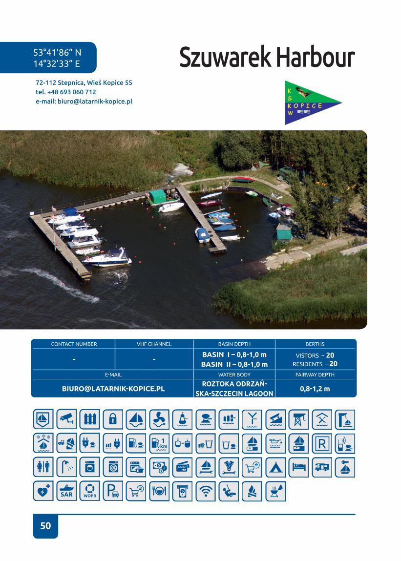
50
Szuwarek Harbour72-112 Stepnica, Wieś Kopice 55tel. +48 693 060 712e-mail: [email protected]
53°41’86” N 14°32’33” E
CONTACT NUMBER VHF CHANNEL BASIN DEPTH BERTHS
- -BASIN I – 0,8-1,0 mBASIN II – 0,8-1,0 m
VISTORS – 20RESIDENTS – 20
E-MAIL WATER BODY FAIRWAY DEPTH
[email protected] ODRZAŃ-
SKA-SZCZECIN LAGOON0,8-1,2 m

51
The marina can be accessed exclusively by vessels with a draught of no more than 0�40 m� The approach to the marina is unmarked, despite the fact that at the distance of over 0�5 Mm it runs over the Kopicka Shallows. The western edge of the shallows is particularly dangerous, featuring highly changeable course and numerous shoal patches; the danger is even higher when waves have been stirred on the water reservoir�
According to locally-sourced information, you should not steer directly towards the entrance while sailing into the marina, but you should rather aim at a clump of trees found on the left looking from the water (approx� 500 m), then you should sail along the shore towards the marina entrance� You should not draw up to an external (western) landing on the outer side on account of stones�
The trail runs across “Białodrzew Kopicki” reserve area and it constitutes a risk to the protected water plants�
The marina itself, created by sailing and motor boating enthusiasts, is comprised of
two basins for water equipment measuring up to 8 m in length and with a draught of up to 0.7 m. “Szuwarek” Kopice Water Sports Club administers the marina� The marina operates all the year round, and provides security services from June to September�
Traditionally, at the start of the season, a family picnic is held� Rental of small water equipment (kayaks, boats, pedal boats, sailing boats) operates at the marina and cruises on a motor catamaran are organized around the Szczecin Lagoon�
Kopice is a small village lying at the road from Stepnica to Czarnocin� Presently, it is chiefly made up of holiday homes. In the vicinity there are mostly forests and meadows, appealing to bicycle tourism and hiking enthusiasts. Within the distance of an hour’s walk along the paths running through a picturesque forest bordering the lagoon lies Czarnocin village that boasts an architectural curiosity in the form of “Frajda” holiday resort building and the neighbourhood of the Szczecin Lagoon Nature Park. Visitors can enjoy the park from designated walking trails and viewing towers�
Stepnica
RoztokaOdrzańska
08
08
08
08
08
08

52
CONTACT NUMBER VHF CHANNEL BASIN DEPTH BERTHS
+48 91 312 83 4671
(11 HARBOUR MASTER’S OFFICE)1,5-2,5 m VISITORS – 30
RESIDENT – 0E-MAIL WATER BODY FAIRWAY DEPTH
[email protected] ODRZAŃSKA-
-SZCZECIN LAGOON5 m
72-020 Trzebież, ul. Portowa 23tel. + 48 91 312 83 46e-mail: [email protected]
53°40’00” N14°31’02” E Port in Trzebież

53
You can enter the port from the south or from the north. Both entries are marked. Their axes are designated with illuminated leading marks, which facilitate night and day navigation�The southern approach starts in the Odrzańska Roztoka at buoy No 15 (green buoy on the left of the water lane, when sailing from Szczecin to Świnoujście). When entering through the southern approach, we pass the buoy on the portside and we follow course 301.2°; to facilitate entry to port, you need to align the yacht with the leading marks. Mid-way we will be passing two buoys TS-1 and TS-2, following which we sail between the port heads� When entering port from the left side, we will first be passing a commercial basin with Ladziński Yacht Shipyard and a SAR base, the Maritime Office wharf and a refuelling station� We leave buoy No 15 on the portside� Sailing from the Szczecin Lagoon, we begin our approach from TN-A buoy, once it has been passed we assume course 150°� On the way we will be passing TN-B, TN-C, TN-D, TN-E buoys until we reach the port heads� In order to facilitate entry to port, you need to align the yacht with the light leading marks (150.2°). We leave TN-A light buoy and other buoys with no lights on the starboard side� When you reach TN-D buoy, shoals may occur� To
reach the port in Trzebież we need to pass basins A and B of the Main Sailing Centre� The port, administered by the Maritime Office, begins at the point when you reach a refuelling station� At the western side of the water lane there are significant shoals, that is why water lane line must not be crossed at that point – even by yachts with small draught� Overall, in case of both approach routes, if yachts with greater draught sail outside the limits of these two routes, they will likely run aground.
Port in Trzebież is slightly more sheltered and quieter than the Main Sailing Centre wharf� There are three small basins for fishing boats and a slipway in the commercial basin� Between the southern basin and the Main Sailing Centre there is a transit wharf, where the refuelling station and the boatswain’s office are located. We can often see Maritime Office vessels mooring in the commercial basin and at the wharf along with ships of various services and inspections� The port has the infrastructure enabling the collection of oily waters and restocking of water; there is access to electric power and toilets�
Trzebież
Strong winds from N directions are unfavourable during the stay at and entry to the port�
RoztokaOdrzańska
34
38
31
57
5656
32 36
34
12
12
09
22
43
16
15
33
UL. RYBACKA
UL. KWIATKOWSKIEGO
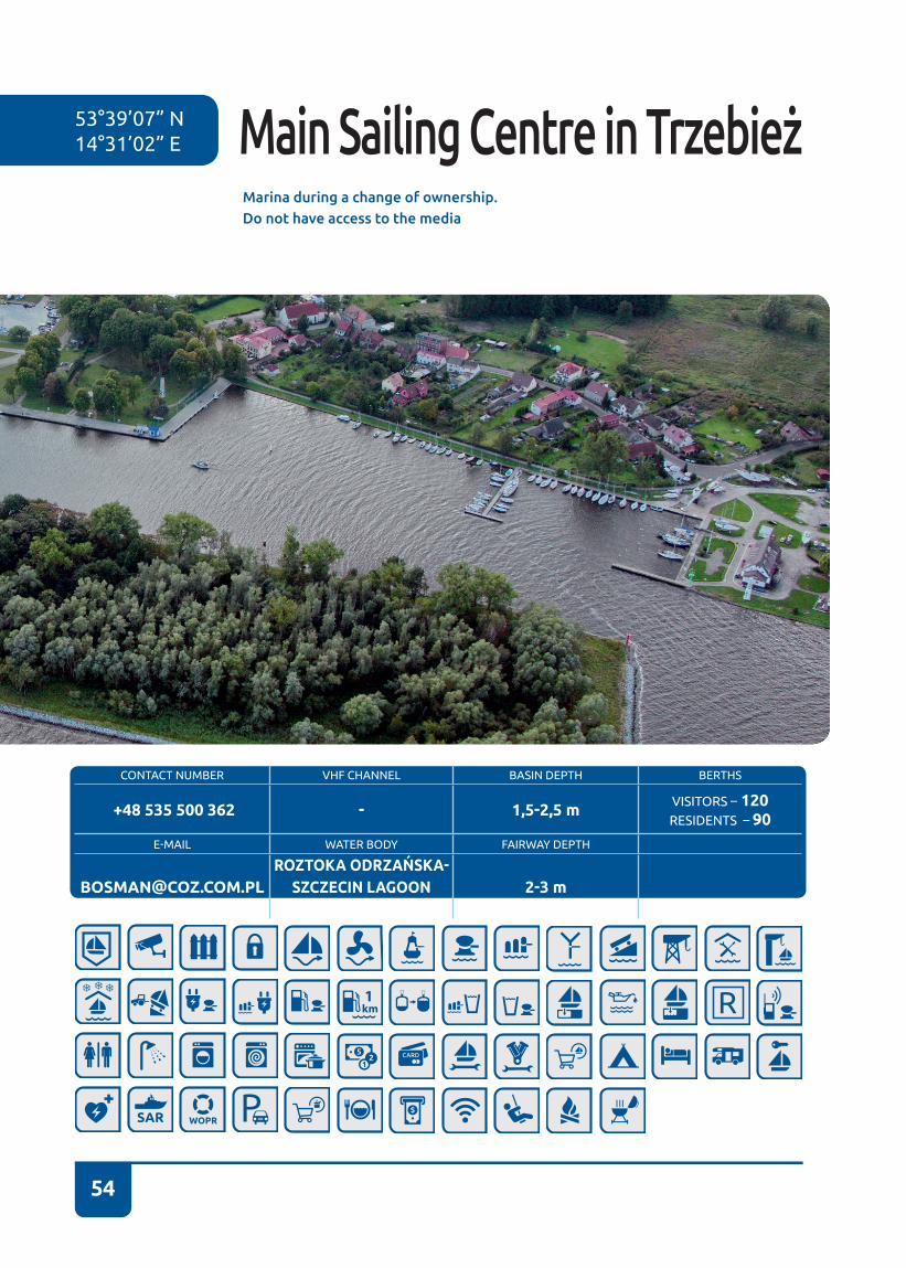
54
CONTACT NUMBER VHF CHANNEL BASIN DEPTH BERTHS
+48 535 500 362 - 1,5-2,5 m VISITORS – 120RESIDENTS – 90
E-MAIL WATER BODY FAIRWAY DEPTH
[email protected] ODRZAŃSKA-
SZCZECIN LAGOON 2-3 m
Marina during a change of ownership. Do not have access to the media
53°39’07” N14°31’02” E Main Sailing Centre in Trzebież

55
The Main Sailing Centre can be approached from the south and the north� Both en-tries are marked. Their axes are designat-ed with illuminated leading marks, which facilitate night and day navigation� Their axes are designated with illuminated lead-ing marks, which facilitate night and day navigation� The southern approach starts in the Odrzańska Roztoka at buoy No 15 (green buoy on the left of the water lane, sailing from Szczecin to Świnoujście). When entering through the southern approach, we pass the buoy on the portside and we follow course 301.2°; to facilitate entry to port, you need to align the yacht with the leading marks. Mid-way we will be passing two buoys TS-1 and TS-2, following which we sail between the port heads� When entering port from the left side, we will first be passing a commercial basin with Ladziński Yacht Shipyard and a SAR base, the Maritime Office wharf and a refuelling station� We leave buoy No 15 on the port side, and then we reach the Main Sailing Centre�
Sailing from the Szczecin Lagoon, we be-gin our approach from TN-A buoy, once it has been passed, we assume course 150°� On the way we will be passing TN-B, TN-C, TN-D, TN-E buoys until we reach the port heads� In order to facilitate entry to port,
you need to align the yacht with the light leading marks (150.2°). TN-A light buoy and other buoys with no lights are left on the starboard� When you reach TN-D buoy, shoals may occur� At the western side of the water lane there are significant shoals, that is why water lane line must not be crossed at that point – even by yachts with small draught� Overall, in case of both approach routes, if yachts with greater draught sail outside the limits of these two routes, they will likely run aground.
The Main Sailing Centre has two basins� Ba-sin A is located right next to the building, which is slightly covered by the pier during entry� The basin is intended for larger ves-sels� Basin B, separated from basin A with a T-shaped pier, is designated for vessels of smaller draught (up to 1�5 m)� Unfortunate-ly, both basins of the Main Sailing Centre are exposed to the inconvenience of con-stant yacht rocking. In the corner of basin A there is a crane with a hoisting capacity of 30 tons�
Next to the Main Sailing Centre, at the Mar-itime Office wharf, there is a 24-hour refu-elling station�
In case of winds from northerly directions, basin B is exposed to strong waves and
Trzebież
a southern current of up to 1 knot speed. In case of southern winds, waves are much smaller, however, the current is of simi-lar strength and it flows from the north. The Main Sailing Centre is sheltered with a square-shaped, artificial island from the east�
Roztoka Odrzańska
27
24
21
2121
36
38
36
36
2937
35
24
25
29
25
21
17
18
15
14
14
14
18
18
19
19
32
31
12
13
24
32 09
3 1
1
4
2
2
48
46
41
41
UL. RYBACKA
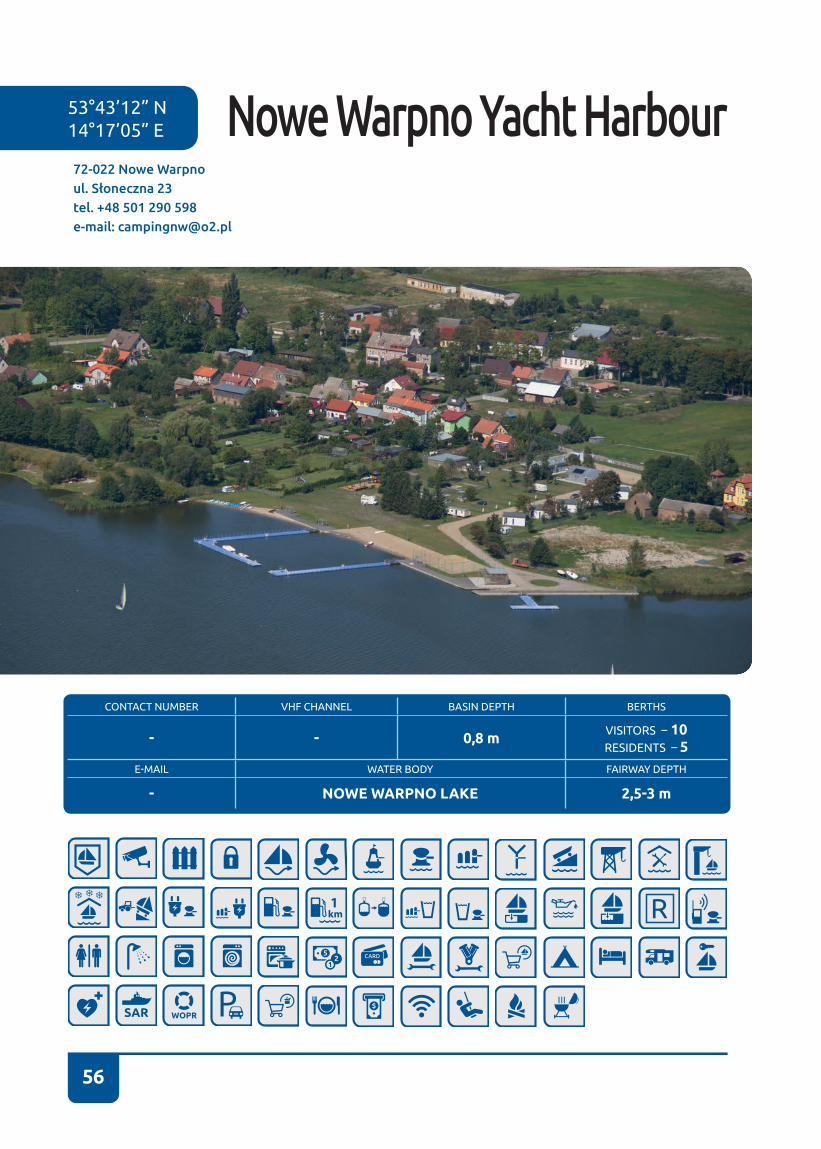
56
53°43’12” N 14°17’05” E
72-022 Nowe Warpnoul. Słoneczna 23tel. +48 501 290 598e-mail: [email protected]
Nowe Warpno Yacht Harbour
CONTACT NUMBER VHF CHANNEL BASIN DEPTH BERTHS
- - 0,8 m VISITORS – 10RESIDENTS – 5
E-MAIL WATER BODY FAIRWAY DEPTH
- NOWE WARPNO LAKE 2,5-3 m
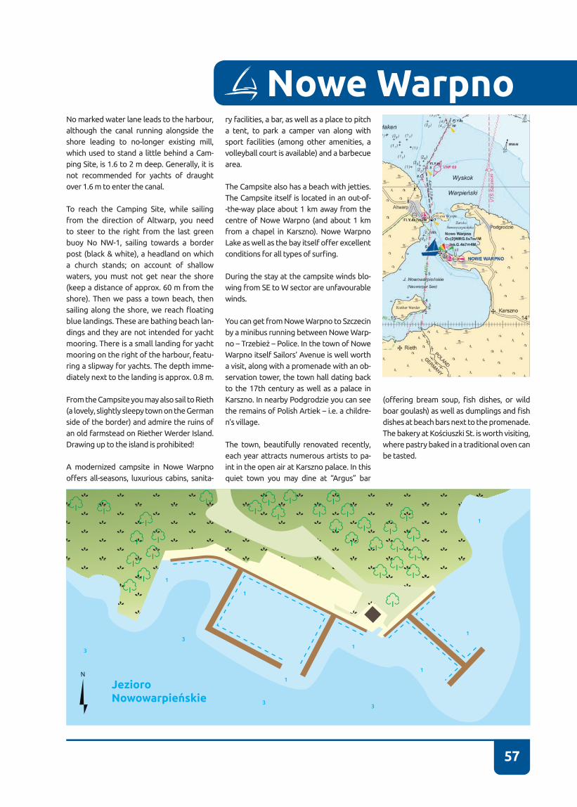
57
Nowe WarpnoNo marked water lane leads to the harbour, although the canal running alongside the shore leading to no-longer existing mill, which used to stand a little behind a Cam-ping Site, is 1�6 to 2 m deep� Generally, it is not recommended for yachts of draught over 1�6 m to enter the canal�
To reach the Camping Site, while sailing from the direction of Altwarp, you need to steer to the right from the last green buoy No NW-1, sailing towards a border post (black & white), a headland on which a church stands; on account of shallow waters, you must not get near the shore (keep a distance of approx. 60 m from the shore)� Then we pass a town beach, then sailing along the shore, we reach floating blue landings� These are bathing beach lan-dings and they are not intended for yacht mooring� There is a small landing for yacht mooring on the right of the harbour, featu-ring a slipway for yachts� The depth imme-diately next to the landing is approx� 0�8 m�
From the Campsite you may also sail to Rieth (a lovely, slightly sleepy town on the German side of the border) and admire the ruins of an old farmstead on Riether Werder Island� Drawing up to the island is prohibited!
A modernized campsite in Nowe Warpno offers all-seasons, luxurious cabins, sanita-
ry facilities, a bar, as well as a place to pitch a tent, to park a camper van along with sport facilities (among other amenities, a volleyball court is available) and a barbecue area�
The Campsite also has a beach with jetties. The Campsite itself is located in an out-of--the-way place about 1 km away from the centre of Nowe Warpno (and about 1 km from a chapel in Karszno)� Nowe Warpno Lake as well as the bay itself offer excellent conditions for all types of surfing.
During the stay at the campsite winds blo-wing from SE to W sector are unfavourable winds�
You can get from Nowe Warpno to Szczecin by a minibus running between Nowe Warp-no – Trzebież – Police. In the town of Nowe Warpno itself Sailors’ Avenue is well worth a visit, along with a promenade with an ob-servation tower, the town hall dating back to the 17th century as well as a palace in Karszno� In nearby Podgrodzie you can see the remains of Polish Artiek – i.e. a childre-n’s village�
The town, beautifully renovated recently, each year attracts numerous artists to pa-int in the open air at Karszno palace� In this quiet town you may dine at “Argus” bar
(offering bream soup, fish dishes, or wild boar goulash) as well as dumplings and fish dishes at beach bars next to the promenade� The bakery at Kościuszki St. is worth visiting, where pastry baked in a traditional oven can be tasted�
JezioroNowowarpieńskie
1
1
3
3
33
1
1
1
1
1
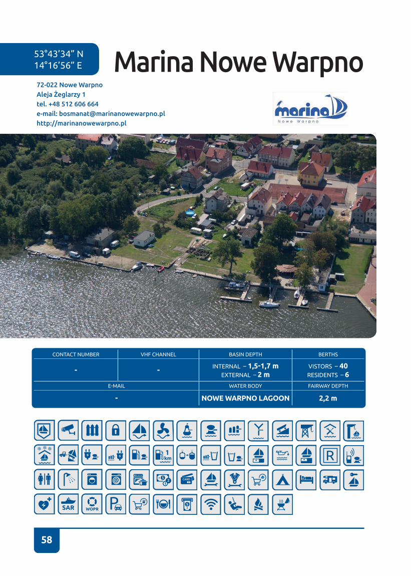
58
53°43’34” N 14°16’56” E
72-022 Nowe WarpnoAleja Żeglarzy 1tel. +48 512 606 664e-mail: [email protected]://marinanowewarpno.pl
Marina Nowe Warpno
CONTACT NUMBER VHF CHANNEL BASIN DEPTH BERTHS
- - INTERNAL – 1,5-1,7 mEXTERNAL – 2 m
VISTORS – 40RESIDENTS – 6
E-MAIL WATER BODY FAIRWAY DEPTH
- NOWE WARPNO LAGOON 2,2 m

59
Nowe Warpno
Nowe Warpno marina lies between a pier and a building of an ice manufacturing plant. The marina comprises five basins of varying depth – from 1�5 m to 2�0 m� You can enter three small basins – that can accept twelve yachts altogether - directly from the side of the water lane� The remaining two basins - each one designated for two yachts - have entries parallel to the water lane. When you reach the first basin you will see a building, and when you get to the second basin there will be a bar�
There is also a slipway at the marina for pulling out fish cutters, drop keel or flat-bottomed yachts. The slipway is not presently suited to launch yachts and motor boats from a trailer� At the end of the marina there is an ice manufacturing plant, a fish warehouse and fish cutters are moored�
We follow the water lane from Stare Warpno towards the pier� On the right of the pier we will see a church tower, then a smaller town hall tower� Once a red buoy (NW4) has been passed, you can head directly to a basin of your choice� Leading
marks on the pier are visible also at night, similarly to some of the floating beacons on the water lane to Nowe Warpno (partly running along the border)�
Frequently sailors take a shortcut to Nowe Warpno and they sail between Łysa Island and the Podgrodzie Peninsula� If you choose to take it, you need to watch out for nets cast in the narrows and keep close to the peninsula� Then you need to steer at the church tower� The shortcut can only be used by yachts with a draught not greater than 1�5 m�
Strong winds from N directions are unfavourable during the stay at and entry to the marina�
The marina is located next to a renovated port boulevard�
UL.
ŹR
ÓD
LAN
A
31
34 14
13
19
11
17
17
18
18
18
18
16
1616
13
2725
24
2
28
2
31
35
33
33
32
3
33
ZatokaNowowarpieńska
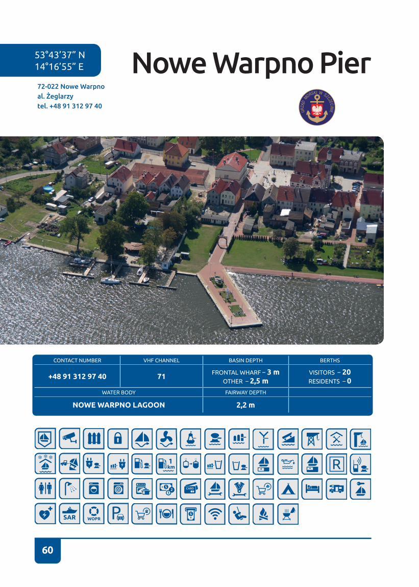
60
53°43’37” N 14°16’55” E
72-022 Nowe Warpnoal. Żeglarzytel. +48 91 312 97 40
Nowe Warpno Pier
CONTACT NUMBER VHF CHANNEL BASIN DEPTH BERTHS
+48 91 312 97 40 71 FRONTAL WHARF – 3 mOTHER – 2,5 m
VISITORS – 20RESIDENTS – 0
WATER BODY FAIRWAY DEPTH
NOWE WARPNO LAGOON 2,2 m

61
Nowe Warpno port, administered by the Maritime Office, comprises the so-called pier and wharf of a former border crossing (the Przemysłowe Wharf). The Przemysłowe Wharf is presently used mostly by fishermen from Trzebież. There are boatswain’s office buildings and sanitary facilities� During the port boatswain’s working hours it is possible to connect to electrical power and water supply on the pier�
From the heads of the Piastowski Canal we navigate to Nowe Warpno, passing on the starboard side a green buoy placed close to breakwater heads and sailing towards TW-4 buoy, being cautious of fishing nets. We then head towards the border buoy, passing on the starboard side an illuminated MOS cardinal buoy, then along yellow lines and along unilluminated border buoys� At buoy No 14, we follow the water lane, designated with green and red buoys, arranged in a passing bay in the direction of Altwarp� We pass a narrow passage between the port in Altwarp and Łysa Island, then we steer towards a church tower following the water lane� From the direction of Szczecin to the buoy we steer towards fairway arch No 2�
We can also select a shortcut from buoy 5 between fairway arch Nos 2 and 3 and then sail on along WWE and WN-E cardinal marks (53°45′82′N, 14°19′08′E), then sail towards the border buoy No 14� Beware of fishing nets and significant depth changes on that route�
Passing Łysa Island, we then sail along the water lane to Stare Warpno towards the pier� On the right of the pier we will see a church tower, then a smaller town hall tower� Once we pass a red buoy (NW-4), we can steer directly towards the pier or further on to the Przemysłowe Wharf. A mobile operator mast stands within the premises of the former border crossing� A belt of rushes stretches between Nowe Warpno Marina and the Przemysłowe Wharf�
Frequently sailors take a shortcut to Nowe Warpno and they sail between Łysa Island and the Podgrodzie Peninsula� If you choose to take it, you need to watch out for nets cast in the narrows and keep close to the peninsula� Then you need to steer at the church tower� The shortcut can only be used by yachts with a draught not greater than 1�5 m�
Nowe Warpno
UL.
ŹR
ÓD
LAN
A
31
34 14
13
19
11
17
17
18
18
18
18
16
1616
13
2725
24
22
2
28
2
31
35
33
33
32
3
33
ZatokaNowowarpieńska
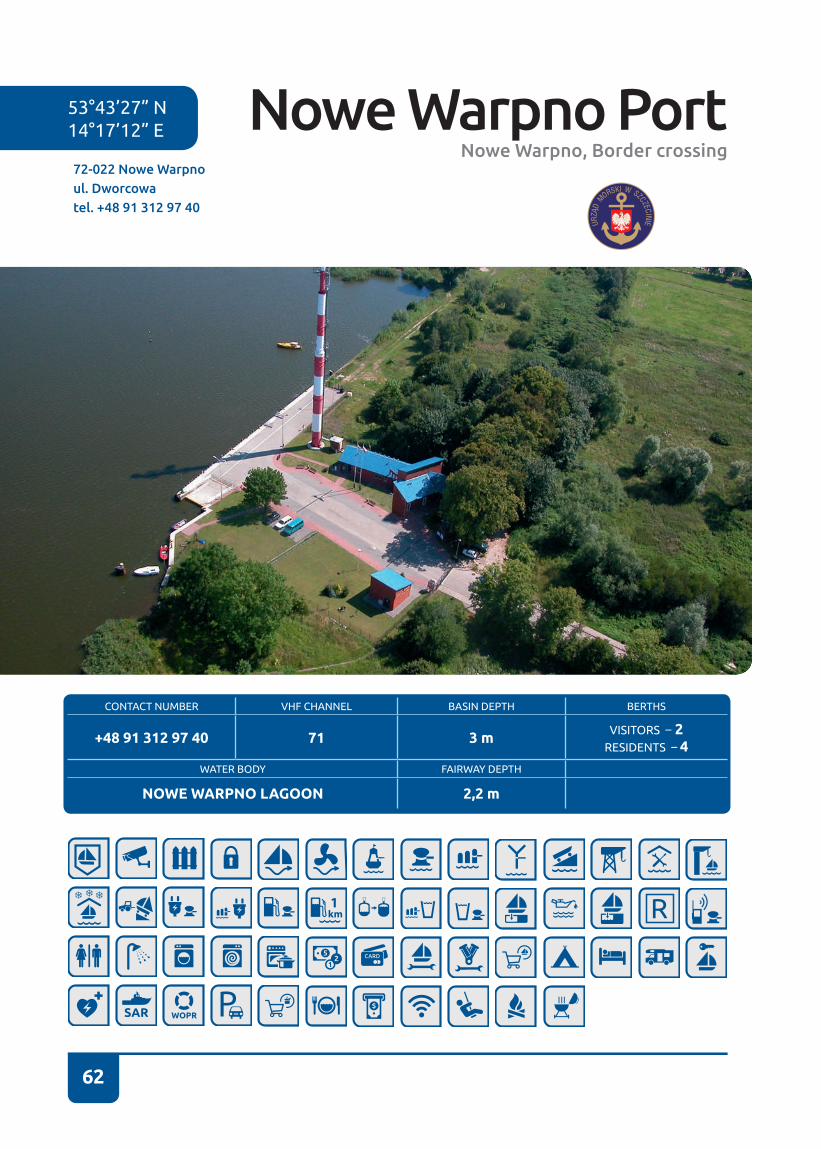
62
72-022 Nowe Warpnoul. Dworcowatel. +48 91 312 97 40
53°43’27” N 14°17’12” E Nowe Warpno Port
Nowe Warpno, Border crossing
CONTACT NUMBER VHF CHANNEL BASIN DEPTH BERTHS
+48 91 312 97 40 71 3 m VISITORS – 2RESIDENTS – 4
WATER BODY FAIRWAY DEPTH
NOWE WARPNO LAGOON 2,2 m

63
Nowe Warpno port, administered by the Maritime Office, comprises the so-called pier and wharf of a former border crossing (the Przemysłowe Wharf). The Przemysłowe Wharf is presently used mostly by fishermen from Trzebież. There are boatswain’s office buildings and sanitary facilities� During the port boatswain’s working hours it is possible to connect to electrical power and water supply on the pier�
From the heads of the Piastowski Canal we navigate to Nowe Warpno, passing on the starboard a green buoy placed close to breakwater heads and sailing towards TW-4 buoy, being cautious of fishing nets� We then head towards the border buoy, passing on the starboard side an illuminated MOS cardinal buoy, then along yellow lines and along unilluminated border buoys, at buoy No 14, we follow the water lane, designated with green and red buoys, arranged in a passing bay in the direction of Altwarp� We pass a narrow passage between the port in Altwarp and Łysa Island, then we steer towards a church tower following the water lane� From the direction of Szczecin to the buoy we steer towards fairway arch No 2�
We can also select a shortcut from buoy 5 between fairway arch Nos 2 and 3 and then sail on along WWE and WN-E cardinal marks (53°45′82′N, 14°19′08′E), then sail towards the border buoy No 14� Beware of fishing nets and significant depth changes on that route�
Passing Łysa Island, we then sail along the water lane to Stare Warpno towards the pier� On the right of the pier we will see a church tower, then a smaller town hall tower� Once we pass a red buoy (NW-4), we can steer directly towards the pier or further on to the Przemysłowe Wharf. A mobile operator mast stands within the premises of the former border crossing� A belt of rushes stretches between Nowe Warpno Marina and the Przemysłowe Wharf�
Frequently sailors take a shortcut to Nowe Warpno and they sail between Łysa Island and the Podgrodzie Peninsula� If you choose to take it, you need to watch out for nets cast in the narrows and keep close to the peninsula� Then you need to steer at the church tower� The shortcut can only be used by yachts with a draught not greater than 1�5 m�
Nowe Warpno
Zatoka Nowowarpieńska
22
22
3
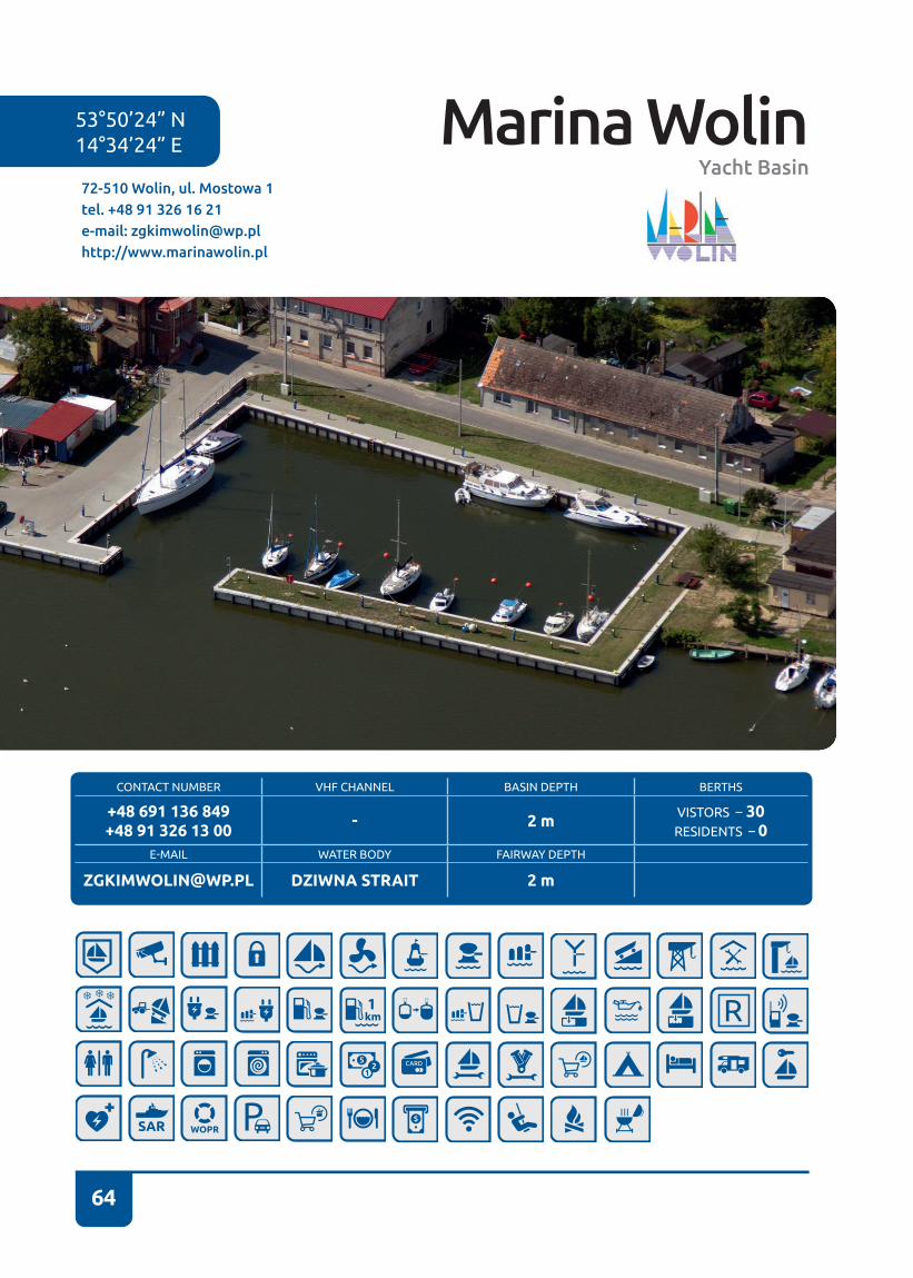
64
CONTACT NUMBER VHF CHANNEL BASIN DEPTH BERTHS
+48 691 136 849+48 91 326 13 00 - 2 m VISTORS – 30
RESIDENTS – 0E-MAIL WATER BODY FAIRWAY DEPTH
[email protected] DZIWNA STRAIT 2 m
72-510 Wolin, ul. Mostowa 1tel. +48 91 326 16 21e-mail: [email protected]://www.marinawolin.pl
53°50’24” N14°34’24” E Marina Wolin
Yacht Basin
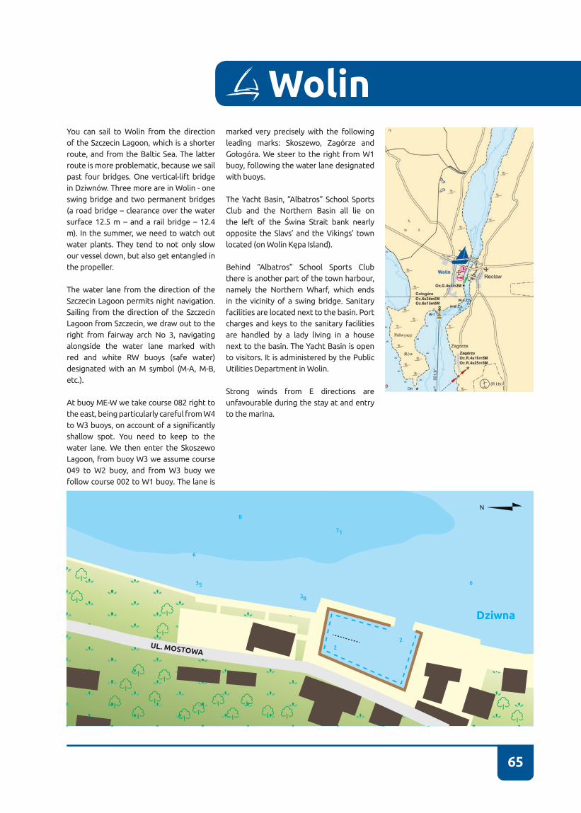
65
You can sail to Wolin from the direction of the Szczecin Lagoon, which is a shorter route, and from the Baltic Sea� The latter route is more problematic, because we sail past four bridges� One vertical-lift bridge in Dziwnów. Three more are in Wolin - one swing bridge and two permanent bridges (a road bridge – clearance over the water surface 12�5 m – and a rail bridge – 12�4 m)� In the summer, we need to watch out water plants� They tend to not only slow our vessel down, but also get entangled in the propeller�
The water lane from the direction of the Szczecin Lagoon permits night navigation� Sailing from the direction of the Szczecin Lagoon from Szczecin, we draw out to the right from fairway arch No 3, navigating alongside the water lane marked with red and white RW buoys (safe water) designated with an M symbol (M-A, M-B, etc�)�
At buoy ME-W we take course 082 right to the east, being particularly careful from W4 to W3 buoys, on account of a significantly shallow spot. You need to keep to the water lane. We then enter the Skoszewo Lagoon, from buoy W3 we assume course 049 to W2 buoy, and from W3 buoy we follow course 002 to W1 buoy� The lane is
marked very precisely with the following leading marks: Skoszewo, Zagórze and Gołogóra. We steer to the right from W1 buoy, following the water lane designated with buoys�
The Yacht Basin, “Albatros” School Sports Club and the Northern Basin all lie on the left of the Świna Strait bank nearly opposite the Slavs’ and the Vikings’ town located (on Wolin Kępa Island).
Behind “Albatros” School Sports Club there is another part of the town harbour, namely the Northern Wharf, which ends in the vicinity of a swing bridge� Sanitary facilities are located next to the basin� Port charges and keys to the sanitary facilities are handled by a lady living in a house next to the basin� The Yacht Basin is open to visitors� It is administered by the Public Utilities Department in Wolin�
Strong winds from E directions are unfavourable during the stay at and entry to the marina�
Wolin
Dziwna
38
22
35
6
6
8
71
UL. MOSTOWA
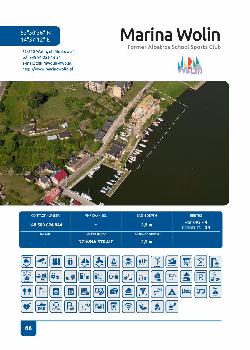
66
CONTACT NUMBER VHF CHANNEL BASIN DEPTH BERTHS
+48 500 024 844 - 2,5 m VISITORS – 4RESIDENTS – 24
E-MAIL WATER BODY FAIRWAY DEPTH
- DZIWNA STRAIT 2,5 m
53°50’36” N14°37’12” E
72-510 Wolin, ul. Mostowa 1tel. +48 91 326 16 21e-mail: [email protected]://www.marinawolin.pl
Marina WolinFormer Albatros School Sports Club
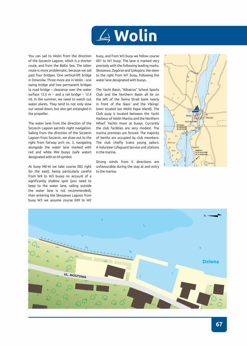
67
WolinYou can sail to Wolin from the direction of the Szczecin Lagoon, which is a shorter route, and from the Baltic Sea� The latter route is more problematic, because we sail past four bridges� One vertical-lift bridge in Dziwnów. Three more are in Wolin - one swing bridge and two permanent bridges (a road bridge – clearance over the water surface 12�5 m – and a rail bridge – 12�4 m)� In the summer, we need to watch out water plants� They tend to not only slow our vessel down, but also get entangled in the propeller�
The water lane from the direction of the Szczecin Lagoon permits night navigation� Sailing from the direction of the Szczecin Lagoon from Szczecin, we draw out to the right from fairway arch no� 3, navigating alongside the water lane marked with red and white RW buoys (safe water) designated with an M symbol�
At buoy ME-W we take course 082 right (to the east), being particularly careful from W4 to W3 buoys on account of a significantly shallow spot (you need to keep to the water lane, sailing outside the water lane is not recommended), then entering the Skoszewo Lagoon from buoy W3 we assume course 049 to W2
buoy, and from W3 buoy we follow course 001 to W1 buoy. The lane is marked very precisely with the following leading marks: Skoszewo, Zagórze and Gołogóra. We steer to the right from W1 buoy, following the water lane designated with buoys�
The Yacht Basin, “Albatros” School Sports Club and the Northern Basin all lie on the left of the Świna Strait bank nearly in front of the Slavs’ and the Vikings’ town located (on Wolin Kępa Island). The Club quay is located between the Yacht Harbour of Wolin Marina and the Northern Wharf� Yachts moor at buoys� Currently the club facilities are very modest� The marina premises are fenced. The majority of berths are occupied by club members� The club chiefly trains young sailors. A Volunteer Lifeguard Service unit stations in the marina�
Strong winds from E directions are unfavourable during the stay at and entry to the marina�
Dziwna
38
35
6
6
8
71
22UL. MOSTOWA
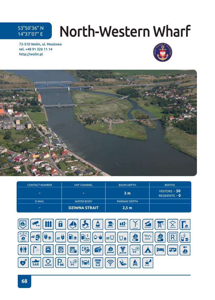
68
CONTACT NUMBER VHF CHANNEL BASIN DEPTH BERTHS
- - 3 m VISITORS – 50RESIDENTS – 0
E-MAIL WATER BODY FAIRWAY DEPTH
- DZIWNA STRAIT 2,5 m
53°50’36” N14°37’07” E
72-510 Wolin, ul. Mostowatel. +48 91 326 11 14http://wolin.pl
North-Western Wharf

69
You can sail to Wolin from the direction of the Szczecin Lagoon, which is a shorter route, and from the Baltic Sea� The latter route is more problematic, because we sail past four bridges� One vertical-lift bridge in Dziwnów. Three more are in Wolin - one swing bridge and two permanent bridges (a road bridge – clearance over the water surface 12�5 m – and a rail bridge – 12�4 m)� In the summer, we need to watch out wa-ter plants� They tend to not only slow our vessel down, but also get entangled in the propeller�
The water lane from the direction of the Szczecin Lagoon permits night navigation� Sailing from the direction of the Szczecin Lagoon from Szczecin, we draw out to the right from fairway arch No 3, navigating alongside the water lane marked with red and white RW buoys (safe water) desig-nated with an M symbol�
At buoy ME-W we take course 082 right (to the east), being particularly careful from W4 to W3 buoys on account of a sig-nificantly shallow spot (you need to keep to the water lane, sailing outside the wa-ter lane is not recommended), then enter-ing the Skoszewo Lagoon from buoy W3 we assume course 049 to W2 buoy, and from W3 buoy we follow course 001 to
W1 buoy. The lane is marked very precise-ly with the following leading marks: Sko-szewo, Zagórze and Gołogóra. We steer to the right from W1 buoy, following the water lane designated with buoys�
The Yacht Basin, “Albatros” School Sports Club and the Northern Basin all lie on the left of the Świna Strait bank (sailing from the Szczecin Lagoon) nearly in front of the Slavs’ and the Vikings’ town located (on Wolin Kępa Island). Wolin Cathedral is in front of the Northern Wharf�
The Northern Wharf starts several hun-dred meters behind “Albatros” School Sports Club towards the bridge and it ends in the vicinity of the swing bridge� Presently, some modest sanitary facilities are available next to the basin, as well as in the old town� The Northern Wharf is open to visitors� It is administered directly by the Wolin Town Hall�
Strong winds from E directions are unfa-vourable during the stay at and entry to the marina�
Beware of strong currents!
Wolin is a small town lying on the Świna Strait. It is presently known chiefly for the
Wolin
annual Festival of Slavs and Vikings (which is held in early August), during which vis-itors may participate in battle re-enact-ments and observe old customs of Slavs and Vikings. The festival is held around a town run by the Association of Slavs and Vikings Wolin-Vineta Centre.
Dziwna
26
28
3441
38
71
22
65
65
65
63
5
5
4
8
6
6
UL. MOSTOWA
UL. KATEDRALNA UL.
ŚW
IATO
WID
A
UL.
ZA
MKO
WA

70
CONTACT NUMBER VHF CHANNEL BASIN DEPTH BERTHS
+ 48 885 514 000 - 2,5 m VISITORS – 7RESIDENTS – 45
E-MAIL WATER BODY FAIRWAY DEPTH
- WICKO WIELKIE LAKE 3 m
53°52’50” N14°25’31” E
72-500 Międzyzdroje – Wapnica, ul. Turkusowa 3Ctel. +48 91 321 32 93kom.: +48 885 514 000e-mail: [email protected]://www.marina.wapnica.miedzyzdroje.pl
Wapnica – Międzyzdroje
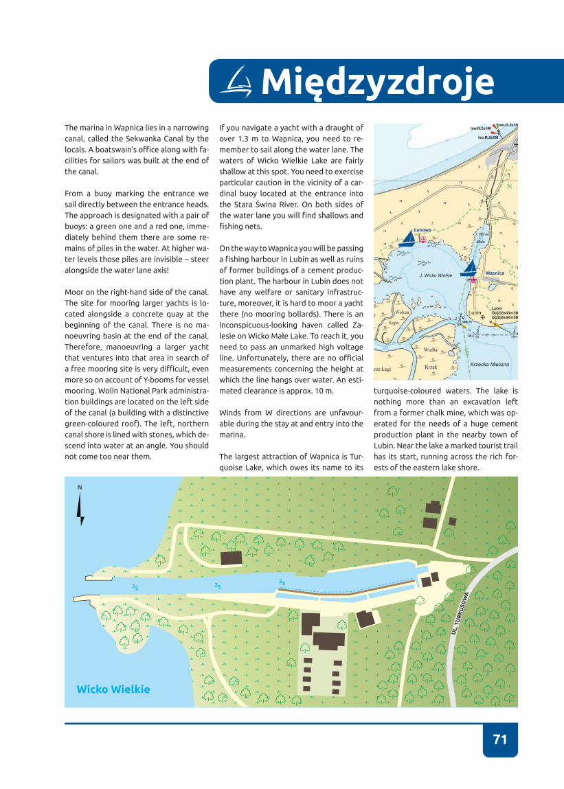
71
MiędzyzdrojeThe marina in Wapnica lies in a narrowing canal, called the Sekwanka Canal by the locals. A boatswain’s office along with fa-cilities for sailors was built at the end of the canal�
From a buoy marking the entrance we sail directly between the entrance heads� The approach is designated with a pair of buoys: a green one and a red one, imme-diately behind them there are some re-mains of piles in the water� At higher wa-ter levels those piles are invisible – steer alongside the water lane axis!
Moor on the right-hand side of the canal� The site for mooring larger yachts is lo-cated alongside a concrete quay at the beginning of the canal� There is no ma-noeuvring basin at the end of the canal� Therefore, manoeuvring a larger yacht that ventures into that area in search of a free mooring site is very difficult, even more so on account of Y-booms for vessel mooring. Wolin National Park administra-tion buildings are located on the left side of the canal (a building with a distinctive green-coloured roof)� The left, northern canal shore is lined with stones, which de-scend into water at an angle� You should not come too near them�
If you navigate a yacht with a draught of over 1�3 m to Wapnica, you need to re-member to sail along the water lane� The waters of Wicko Wielkie Lake are fairly shallow at this spot� You need to exercise particular caution in the vicinity of a car-dinal buoy located at the entrance into the Stara Świna River. On both sides of the water lane you will find shallows and fishing nets.
On the way to Wapnica you will be passing a fishing harbour in Lubin as well as ruins of former buildings of a cement produc-tion plant� The harbour in Lubin does not have any welfare or sanitary infrastruc-ture, moreover, it is hard to moor a yacht there (no mooring bollards)� There is an inconspicuous-looking haven called Za-lesie on Wicko Małe Lake. To reach it, you need to pass an unmarked high voltage line. Unfortunately, there are no official measurements concerning the height at which the line hangs over water� An esti-mated clearance is approx� 10 m�
Winds from W directions are unfavour-able during the stay at and entry into the marina�
The largest attraction of Wapnica is Tur-quoise Lake, which owes its name to its
turquoise-coloured waters. The lake is nothing more than an excavation left from a former chalk mine, which was op-erated for the needs of a huge cement production plant in the nearby town of Lubin. Near the lake a marked tourist trail has its start, running across the rich for-ests of the eastern lake shore.
2525
25
Wicko Wielkie
UL.
TU
RK
USO
WA
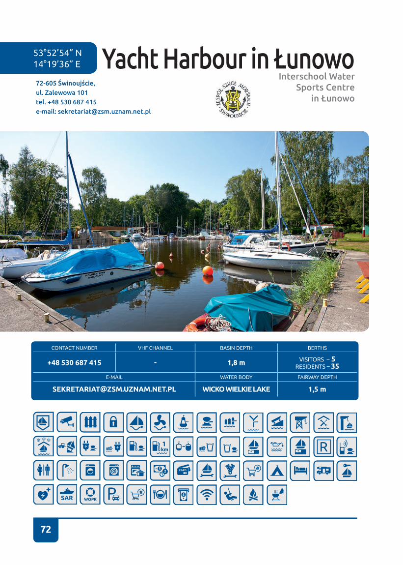
72
Yacht Harbour in ŁunowoInterschool Water
Sports Centre in Łunowo
53°52’54” N 14°19’36” E
72-605 Świnoujście, ul. Zalewowa 101tel. +48 530 687 415e-mail: [email protected]
CONTACT NUMBER VHF CHANNEL BASIN DEPTH BERTHS
+48 530 687 415 - 1,8 m VISITORS – 5RESIDENTS – 35
E-MAIL WATER BODY FAIRWAY DEPTH
[email protected] WICKO WIELKIE LAKE 1,5 m
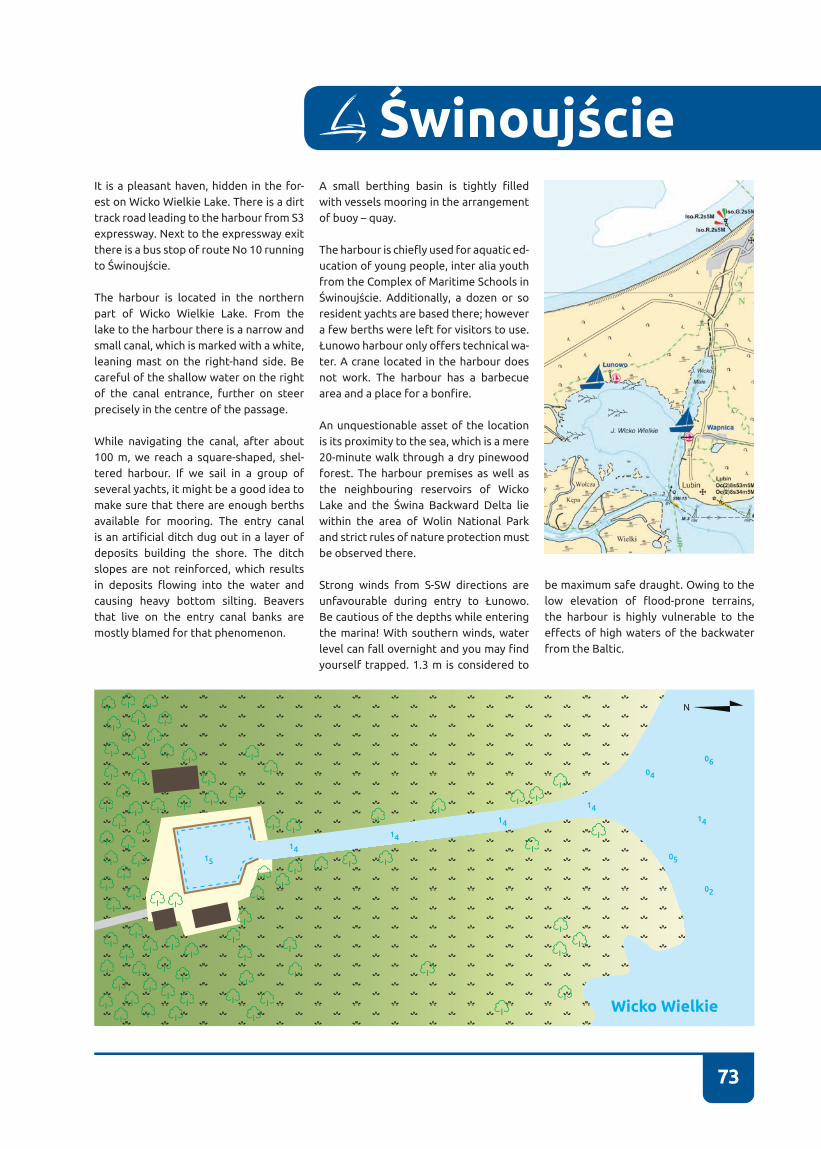
73
It is a pleasant haven, hidden in the for-est on Wicko Wielkie Lake. There is a dirt track road leading to the harbour from S3 expressway� Next to the expressway exit there is a bus stop of route No 10 running to Świnoujście.
The harbour is located in the northern part of Wicko Wielkie Lake. From the lake to the harbour there is a narrow and small canal, which is marked with a white, leaning mast on the right-hand side� Be careful of the shallow water on the right of the canal entrance, further on steer precisely in the centre of the passage�
While navigating the canal, after about 100 m, we reach a square-shaped, shel-tered harbour� If we sail in a group of several yachts, it might be a good idea to make sure that there are enough berths available for mooring� The entry canal is an artificial ditch dug out in a layer of deposits building the shore� The ditch slopes are not reinforced, which results in deposits flowing into the water and causing heavy bottom silting� Beavers that live on the entry canal banks are mostly blamed for that phenomenon�
A small berthing basin is tightly filled with vessels mooring in the arrangement of buoy – quay.
The harbour is chiefly used for aquatic ed-ucation of young people, inter alia youth from the Complex of Maritime Schools in Świnoujście. Additionally, a dozen or so resident yachts are based there; however a few berths were left for visitors to use� Łunowo harbour only offers technical wa-ter� A crane located in the harbour does not work. The harbour has a barbecue area and a place for a bonfire.
An unquestionable asset of the location is its proximity to the sea, which is a mere 20-minute walk through a dry pinewood forest� The harbour premises as well as the neighbouring reservoirs of Wicko Lake and the Świna Backward Delta lie within the area of Wolin National Park and strict rules of nature protection must be observed there�
Strong winds from S-SW directions are unfavourable during entry to Łunowo. Be cautious of the depths while entering the marina! With southern winds, water level can fall overnight and you may find yourself trapped� 1�3 m is considered to
Świnoujście
15
14
14
14
1414
04
05
02
06
Wicko Wielkie
be maximum safe draught� Owing to the low elevation of flood-prone terrains, the harbour is highly vulnerable to the effects of high waters of the backwater from the Baltic�
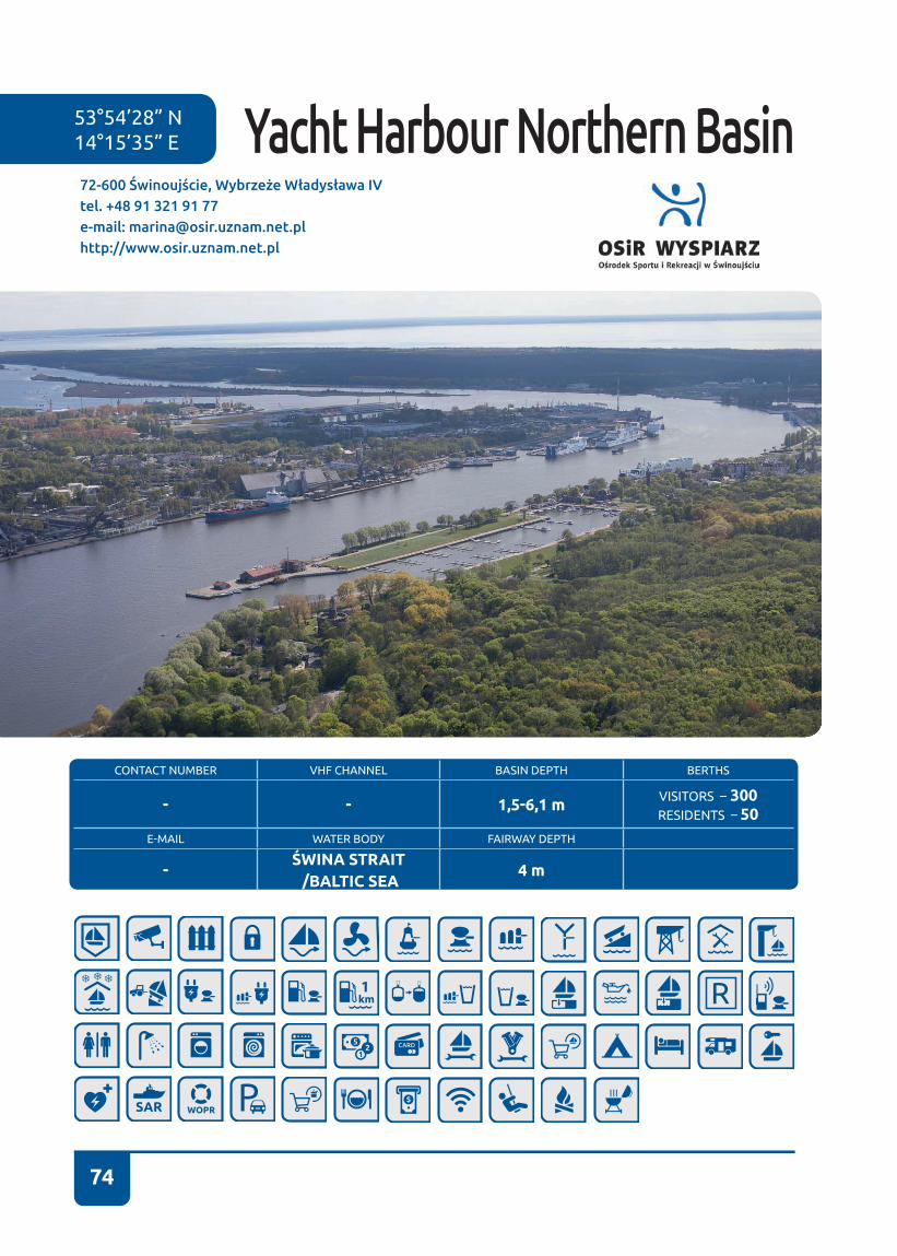
74
CONTACT NUMBER VHF CHANNEL BASIN DEPTH BERTHS
- - 1,5-6,1 m VISITORS – 300RESIDENTS – 50
E-MAIL WATER BODY FAIRWAY DEPTH
-ŚWINA STRAIT /BALTIC SEA
4 m
72-600 Świnoujście, Wybrzeże Władysława IVtel. +48 91 321 91 77e-mail: [email protected]://www.osir.uznam.net.pl
53°54’28” N14°15’35” E Yacht Harbour Northern Basin
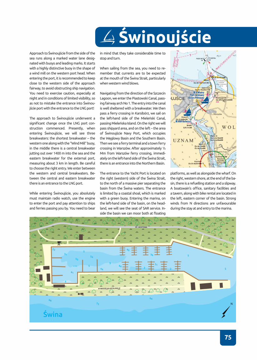
75
Approach to Świnoujście from the side of the sea runs along a marked water lane desig-nated with buoys and leading marks. It starts with a highly distinctive buoy in the shape of a wind mill on the western port head� When entering the port, it is recommended to keep close to the western side of the approach fairway, to avoid obstructing ship navigation� You need to exercise caution, especially at night and in conditions of limited visibility, so as not to mistake the entrance into Świnou-jście port with the entrance to the LNG port!
The approach to Świnoujście underwent a significant change once the LNG port con-struction commenced� Presently, when entering Świnoujście, we will see three breakwaters: the shortest breakwater – the western one along with the “Wind Mill“ buoy, in the middle there is a central breakwater jutting out over 1400 m into the sea and the eastern breakwater for the external port, measuring about 3 km in length. Be careful to choose the right entry� We enter between the western and central breakwaters. Be-tween the central and eastern breakwater there is an entrance to the LNG port�
While entering Świnoujście, you absolutely must maintain radio watch, use the engine to enter the port and pay attention to ships and ferries passing you by� You need to bear
in mind that they take considerable time to stop and turn�
When sailing from the sea, you need to re-member that currents are to be expected at the mouth of the Świna Strait, particularly when western wind blows�
Navigating from the direction of the Szczecin Lagoon, we enter the Piastowski Canal, pass-ing fairway arch No 1� The entry into the canal is well sheltered with a breakwater. We then pass a ferry crossing in Karsibórz, we sail on the left-hand side of the Mieleński Canal, passing Mieleńska Island. On the right we will pass shipyard area, and on the left – the area of Świnoujście Navy Port, which occupies the Węglowy Basin and the Southern Basin. Then we see a ferry terminal and a town ferry crossing in Warszów. After approximately ½ Mm from Warszów ferry crossing, immedi-ately on the left-hand side of the Świna Strait, there is an entrance into the Northern Basin�
The entrance to the Yacht Port is located on the right (western) side of the Świna Strait, to the north of a massive pier separating the basin from the Świna waters. The entrance is limited by a coastal shoal, which is marked with a green buoy. Entering the marina, on the left-hand side of the basin, on the head-land, we will see the seat of SAR service� In-side the basin we can moor both at floating
platforms, as well as alongside the wharf� On the right, western shore, at the end of the ba-sin, there is a refuelling station and a slipway� A boatswain’s office, sanitary facilities and a tavern, along with bike rental are located in the left, eastern corner of the basin� Strong winds from N directions are unfavourable during the stay at and entry to the marina�
Świnoujście

76
CONTACT NUMBER VHF CHANNEL BASIN DEPTH BERTHS
+48 91 324 25 35 - 1,5-2 m VISITORS – 2RESIDENTS – 9
E-MAIL WATER BODY FAIRWAY DEPTH
- ŚWINA STRAIT 4-6 m
72-604 Świnoujście, ul. Steyera 6tel. +48 91 324 25 35 tel./fax +48 91 321 94 35e-mail: [email protected]://jkmwkotwica-swinoujscie.pl
53°54’10” N14°14’43” E “Kotwica” Navy Yacht Club Branch
in Świnoujście
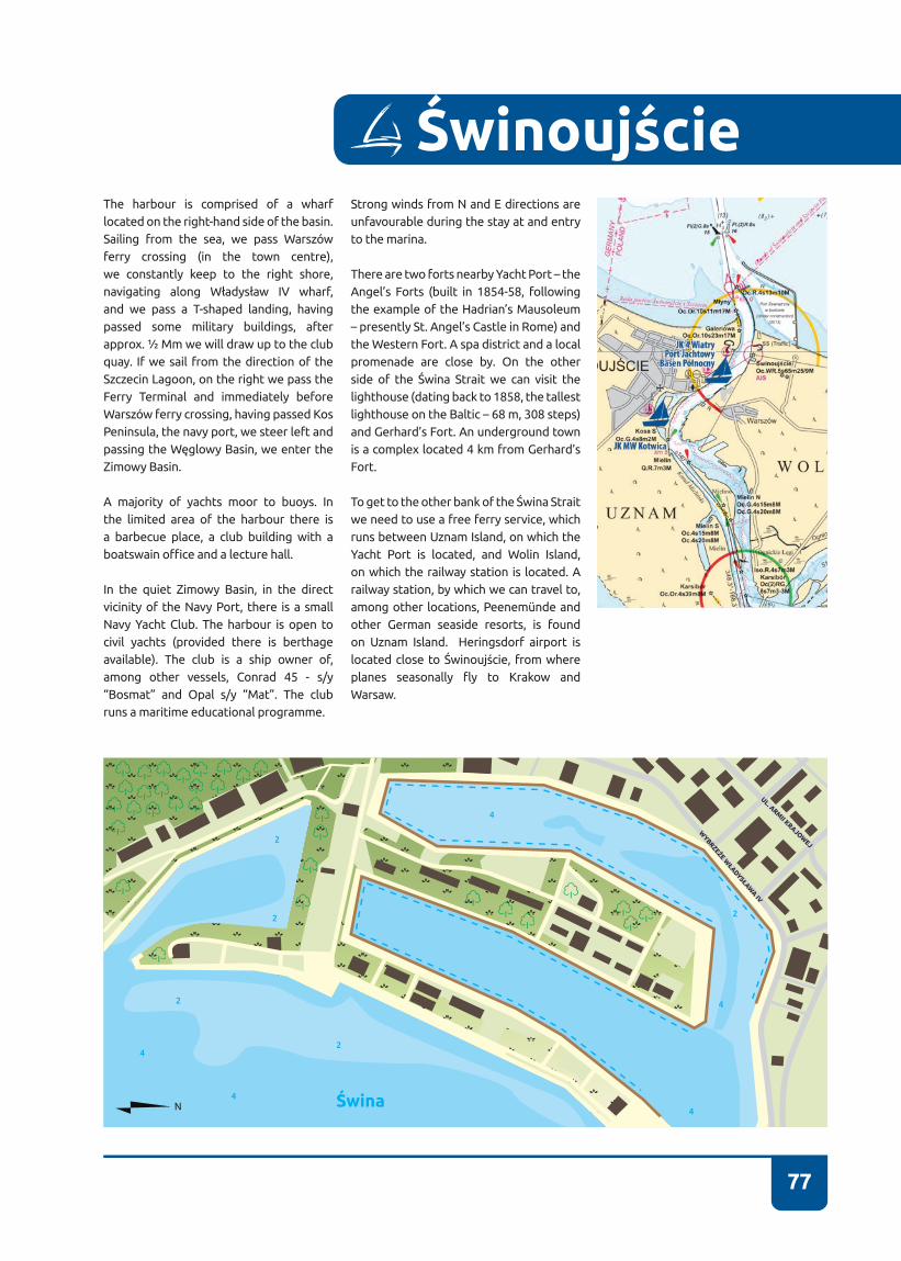
77
The harbour is comprised of a wharf located on the right-hand side of the basin� Sailing from the sea, we pass Warszów ferry crossing (in the town centre), we constantly keep to the right shore, navigating along Władysław IV wharf, and we pass a T-shaped landing, having passed some military buildings, after approx. ½ Mm we will draw up to the club quay. If we sail from the direction of the Szczecin Lagoon, on the right we pass the Ferry Terminal and immediately before Warszów ferry crossing, having passed Kos Peninsula, the navy port, we steer left and passing the Węglowy Basin, we enter the Zimowy Basin.
A majority of yachts moor to buoys. In the limited area of the harbour there is a barbecue place, a club building with a boatswain office and a lecture hall.
In the quiet Zimowy Basin, in the direct vicinity of the Navy Port, there is a small Navy Yacht Club� The harbour is open to civil yachts (provided there is berthage available)� The club is a ship owner of, among other vessels, Conrad 45 - s/y “Bosmat” and Opal s/y “Mat”. The club runs a maritime educational programme�
Strong winds from N and E directions are unfavourable during the stay at and entry to the marina�
There are two forts nearby Yacht Port – the Angel’s Forts (built in 1854-58, following the example of the Hadrian’s Mausoleum – presently St� Angel’s Castle in Rome) and the Western Fort� A spa district and a local promenade are close by� On the other side of the Świna Strait we can visit the lighthouse (dating back to 1858, the tallest lighthouse on the Baltic – 68 m, 308 steps) and Gerhard’s Fort� An underground town is a complex located 4 km from Gerhard’s Fort�
To get to the other bank of the Świna Strait we need to use a free ferry service, which runs between Uznam Island, on which the Yacht Port is located, and Wolin Island, on which the railway station is located� A railway station, by which we can travel to, among other locations, Peenemünde and other German seaside resorts, is found on Uznam Island� Heringsdorf airport is located close to Świnoujście, from where planes seasonally fly to Krakow and Warsaw�
Świnoujście
Świna
4
2
4
4
4
42
2
2
2
UL. ARMII KRAJOW
EJ
WYBRZEŻE W
ŁADYSŁAWA IV
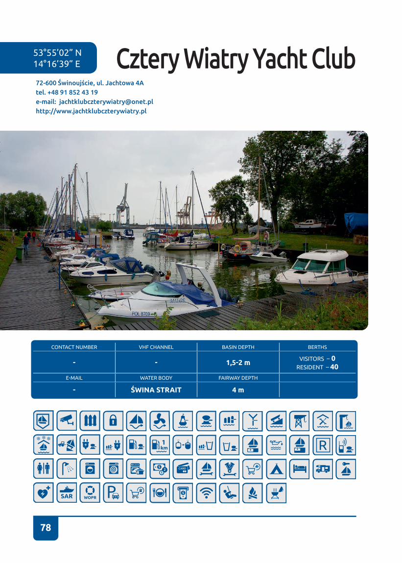
78
CONTACT NUMBER VHF CHANNEL BASIN DEPTH BERTHS
- - 1,5-2 m VISITORS – 0RESIDENT – 40
E-MAIL WATER BODY FAIRWAY DEPTH
- ŚWINA STRAIT 4 m
72-600 Świnoujście, ul. Jachtowa 4Atel. +48 91 852 43 19e-mail: [email protected]://www.jachtklubczterywiatry.pl
53°55’02” N14°16’39” E Cztery Wiatry Yacht Club
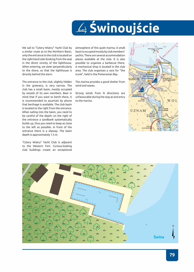
79
ŚwinoujścieWe sail to “Cztery Wiatry” Yacht Club by a similar route as to the Northern Basin, only the entrance to the club is located on the right-hand side (looking from the sea) in the direct vicinity of the lighthouse� When entering, we steer perpendicularly to the shore, so that the lighthouse is directly behind the stern�
The entrance to the club, slightly hidden in the greenery, is very narrow� The club has a small basin, mostly occupied by vessels of its own members� Bear in mind that if you want to berth there, it is recommended to ascertain by phone that berthage is available� The club basin is located to the right from the entrance� When sailing into the basin, you need to be careful of the depth: on the right of the entrance a sandbank systematically builds up, thus you need to keep as close to the left as possible� In front of the entrance there is a slipway� The basin depth is approximately 1�5 m�
“Cztery Wiatry” Yacht Club is adjacent to the Western Fort. Curious-looking club buildings create an exceptional
atmosphere of this quiet marina. A small basin is occupied mostly by club members’ yachts� There are several accommodation places available at the club� It is also possible to organize a barbecue there� A mechanical shop is located in the club area. The club organizes a race for “the trunk”, held in the Pomeranian Bay.
The marina provides a good shelter from wind and waves�
Strong winds from N directions are unfavourable during the stay at and entry to the marina�
Świna
15
17
16
4

80
53°51’03” N 14°17’26” E
CONTACT NUMBER VHF CHANNEL BASIN DEPTH BERTHS
+48 502 157 204 - 1 m VISITORS – 4RESIDENTS – 25
AKWEN FAIRWAY DEPTH
STARA ŚWINA BROADS 1 m
72 -603 Świnoujście, ul. 1 Maja 5atel. +48 91 322 14 48kom.: +48 502 157 204e -mail: [email protected]://www.karsibor.eu
Marina Karsibór
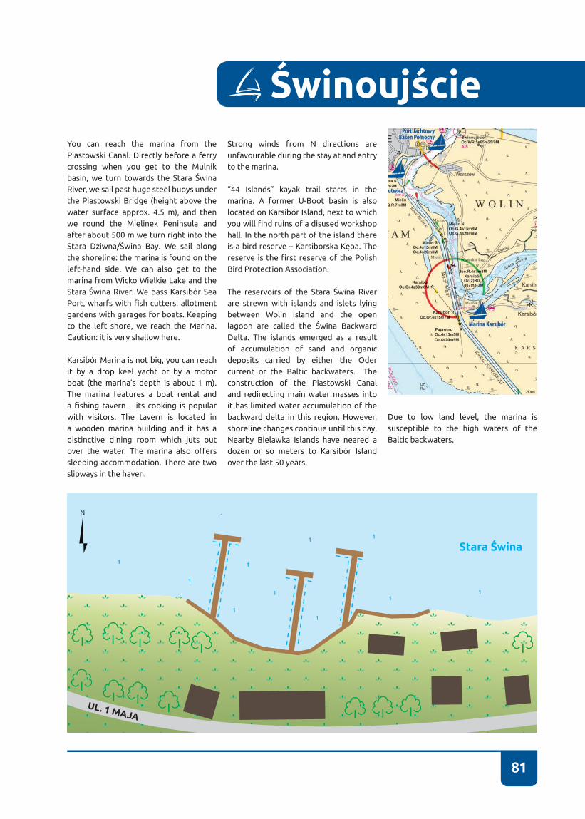
81
You can reach the marina from the Piastowski Canal. Directly before a ferry crossing when you get to the Mulnik basin, we turn towards the Stara Świna River, we sail past huge steel buoys under the Piastowski Bridge (height above the water surface approx� 4�5 m), and then we round the Mielinek Peninsula and after about 500 m we turn right into the Stara Dziwna/Świna Bay. We sail along the shoreline: the marina is found on the left-hand side� We can also get to the marina from Wicko Wielkie Lake and the Stara Świna River. We pass Karsibór Sea Port, wharfs with fish cutters, allotment gardens with garages for boats� Keeping to the left shore, we reach the Marina� Caution: it is very shallow here.
Karsibór Marina is not big, you can reach it by a drop keel yacht or by a motor boat (the marina’s depth is about 1 m)� The marina features a boat rental and a fishing tavern – its cooking is popular with visitors� The tavern is located in a wooden marina building and it has a distinctive dining room which juts out over the water. The marina also offers sleeping accommodation� There are two slipways in the haven�
Strong winds from N directions are unfavourable during the stay at and entry to the marina�
“44 Islands” kayak trail starts in the marina� A former U-Boot basin is also located on Karsibór Island, next to which you will find ruins of a disused workshop hall� In the north part of the island there is a bird reserve – Karsiborska Kępa. The reserve is the first reserve of the Polish Bird Protection Association�
The reservoirs of the Stara Świna River are strewn with islands and islets lying between Wolin Island and the open lagoon are called the Świna Backward Delta� The islands emerged as a result of accumulation of sand and organic deposits carried by either the Oder current or the Baltic backwaters. The construction of the Piastowski Canal and redirecting main water masses into it has limited water accumulation of the backward delta in this region. However, shoreline changes continue until this day� Nearby Bielawka Islands have neared a dozen or so meters to Karsibór Island over the last 50 years�
Świnoujście
Due to low land level, the marina is susceptible to the high waters of the Baltic backwaters.
Stara Świna
UL. 1 MAJA
1
1
1
1
1
1
11
1
1
1
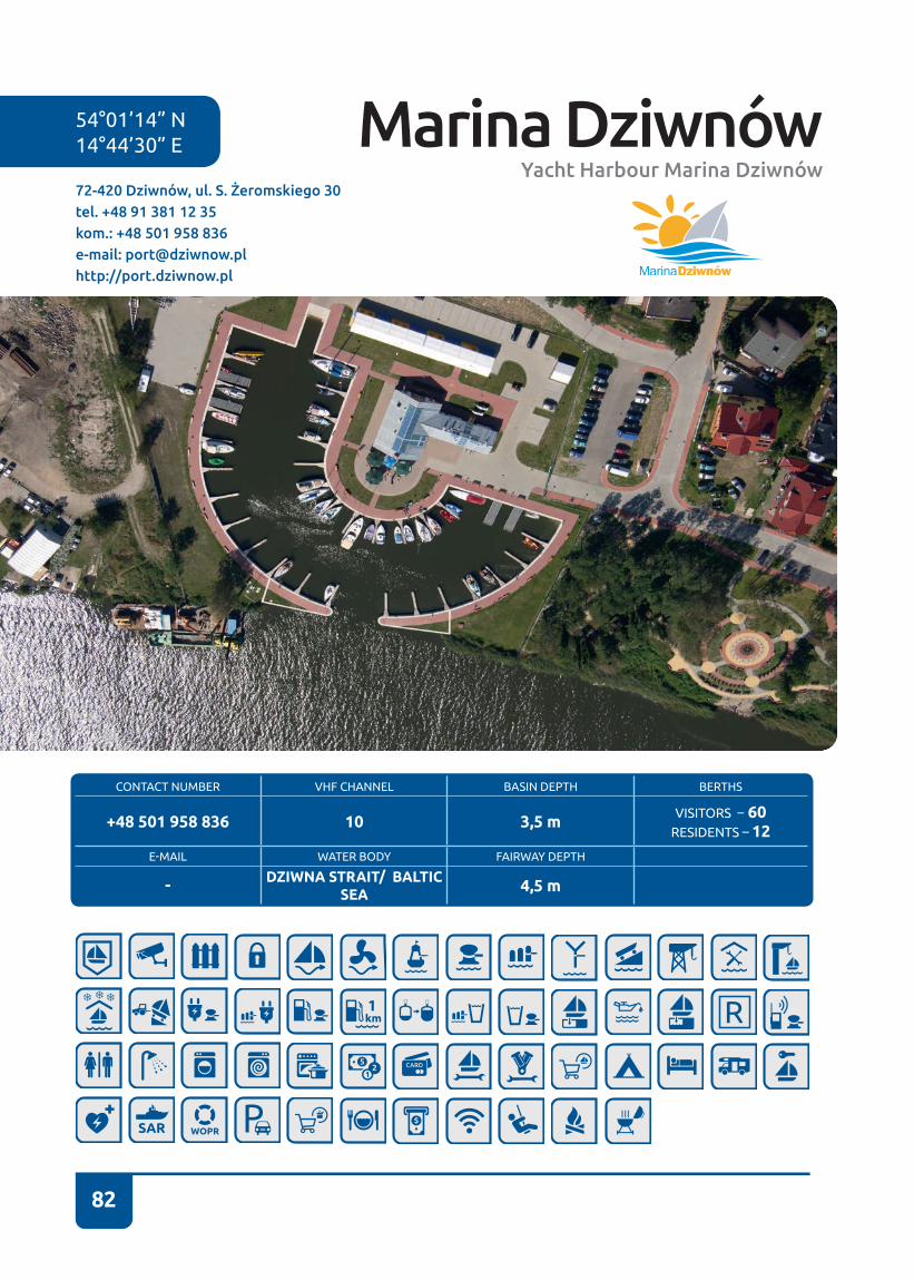
82
54°01’14” N 14°44’30” E
CONTACT NUMBER VHF CHANNEL BASIN DEPTH BERTHS
+48 501 958 836 10 3,5 m VISITORS – 60RESIDENTS – 12
E-MAIL WATER BODY FAIRWAY DEPTH
- DZIWNA STRAIT/ BALTIC SEA 4,5 m
72-420 Dziwnów, ul. S. Żeromskiego 30tel. +48 91 381 12 35kom.: +48 501 958 836e-mail: [email protected]://port.dziwnow.pl
Marina DziwnówYacht Harbour Marina Dziwnów

83
You can get to the marina both from the direc-tion of the sea (definitively an easier way), and from the direction of the lagoon on the Dziw-na Strait (decidedly a far more difficult, but also more picturesque route). From the sea we steer to a white and red DZI buoy (leading mark course 142.5°) in the direction of the break-water heads jutting out to the sea. Caution! If western winds persist over a long period, you need to account for a fairly strong transverse current flowing in the easterly direction. In case of strong eastern winds, the current flows in the westerly direction� On the left side we pass a concrete quay at the boatswain’s office, en-trance to a fishing port and a SAR base. Imme-diately behind the base there is an entrance to the basin of a new yacht harbour�
Despite its inconspicuous shape, the marina permits mooring vessels up to 17 m long� Ac-commodation berths designated for such long yachts are found on both ends of the semi-cir-cle. Manoeuvring in the basin requires signifi-cant caution on account of cramped conditions�
Opposite the entrance there is a building with all welfare facilities, a boatswain’s office, a meeting room and a café� Slipways are locat-ed on both ends of the semi-circle� Yachts moor to Y-booms�
Sailing further, we need to take into account a bridge� It is opened at every even hour� The
lifted bridge span is on the left-hand side of the bridge. Traffic is controlled with traffic lights – we sail when it’s green, we wait when it’s red, without blocking the space for vessels navigat-ing from the direction of the lagoon� The inten-tion of crossing the bridge must be reported to a UKF operator on channel 10 or at the Har-bour Master’s Office in Dziwnów. Once we sail past the bridge, we will be passing a refuelling station (it allows refuelling from the water), a small shipyard, a wharf for fishing cutters and a passenger wharf with modern variations of pirate ships, until we reach a seasonal harbour at Wybrzeże Kościuszkowskie St.
In the seasonal harbour there is a small boat-swain’s office along with sanitary facilities. Yachts moor to Y-booms or along the shore�
Navigating from the direction of Wolin, we pass a swing bridge in Wolin and two permanent bridges� Then we head along the water lane – in case of keel boats you need to bear in mind that depth must be watched� We move along the Dziwna Strait, at buoys Nos 19 and 18 we sail around Chrząszczewka Island - we steer to the left� Then from K3 buoy we steer towards K1 buoy, assuming NE direction. Monitoring the depth, we sail along the water lane from buoy 11 as far as buoy No 1� On the left-hand side we pass concrete military installations, we pass the Międzywodzki Peninsula. On the right we have the seasonal harbour, once we pass a
passenger wharf, harbour for fish cutters, ship-yard and refuelling station, we sail on the left of the Świna Strait under a bridge. Entrance to the marina is several hundred meters further on the right�
Strong winds from S directions are unfavour-able during the stay at and entry to the marina�
Dziwnów
Dziwna
35
3535
33
36
36
36
35
34
34
34
34
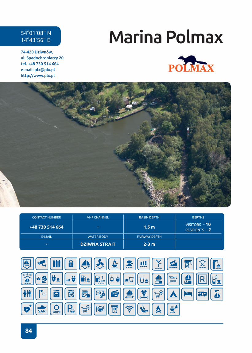
84
54°01’08” N14°43’56” E
74-420 Dziwnów, ul. Spadochroniarzy 20tel. +48 730 514 664e-mail: [email protected]://www.plx.pl
Marina Polmax
CONTACT NUMBER VHF CHANNEL BASIN DEPTH BERTHS
+48 730 514 664 - 1,5 m VISITORS – 10RESIDENTS – 2
E-MAIL WATER BODY FAIRWAY DEPTH
- DZIWNA STRAIT 2-3 m

85
Marina Polmax is a modest, but rather qui-et marina located in the forest, combined with a camping site, offering also places for camper vans�
We can get to Marina Polmax in Dziwnów both from the sea and from the side of the Kamień Pomorski Lagoon by the Dz-iwna Strait� Maximum current speed at the mouth of the Dziwna Strait is about 3 knots, and an average speed is about 1 knot. The direction of the current chang-es depending on wind direction and wind strength�
The harbour is accessible from the sea with winds up to Beaufort force 5� From the direction of the sea we head from DZI buoy (course 142�7°) towards the heads of a breakwater jutting out into the sea or, better still, along the line of illuminated leading marks (142.7°). On the port side we pass a concrete quay at the boatswain’s office, an entry to the fishing basin and a SAR base� The entry to Marina Polmax lies on the right, mid-way between a concrete pier and a fishing basin.
Navigating from the side of the Kamień Po-morski Lagoon, we steer towards K1 buoy, assuming NE direction. Then we sail, watch-ing out for depth changes, along the water
lane from buoy No 11 as far as buoy No 1� On the right we have a seasonal harbour, once we pass a passenger wharf, harbour for fish cutters, shipyard and refuelling sta-tion, we sail on the left of the Świna Strait, then we sail under a bridge. Entrance to Marina Polmax is several hundred meters further on the left
The vertical-lift bridge is opened at every even hour� The intention of passing the bridge must be reported to a UKF radio operator (channel 10) or at the Harbour Master’s Office in Dziwnów. We need to make sure that we do not block the space for vessels navigating from the direction of the lagoon�
Strong winds from NW and SW directions are unfavourable during the stay at and en-try to the marina�
Apart from a beautiful beach, in Dziwnów we will also find the Sports Stars’ Avenue with replicas of Polish athletes’ medals, or a Seaside Park of Miniatures and Railways. We can see there miniatures of lighthous-es of the Polish coast� In the summer Dzi-wnów hosts “Cinema in beach chairs” as well as a Greek Day and Sports Stars’ Festi-val. In 2014, The European Regatta Cup and
the World Championship Regatta in Laser Radial class were held here�
Dziwnów
Dziwna
2
15
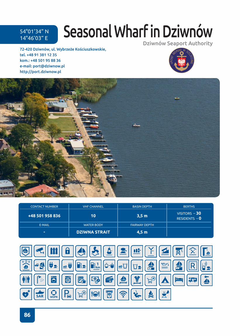
86
54°01’34” N 14°46’03” E
72-420 Dziwnów, ul. Wybrzeże Kościuszkowskie,tel. +48 91 381 12 35kom.: +48 501 95 88 36e-mail: [email protected]://port.dziwnow.pl
CONTACT NUMBER VHF CHANNEL BASIN DEPTH BERTHS
+48 501 958 836 10 3,5 m VISITORS – 30RESIDENTS – 0
E-MAIL WATER BODY FAIRWAY DEPTH
- DZIWNA STRAIT 4,5 m
Seasonal Wharf in DziwnówDziwnów Seaport Authority

87
A small boatswain’s building – a white struc-ture with a sloping roof - along with sanitary facilities is located at the seasonal wharf� The Dziwna bank protection ends at the season-al wharf� We moor to Y-booms or along the shore� The wharf is unfenced and it is located near a pedestrian zone for holidaymakers. Next to the wharf there are some local bars and pubs�
The wharf is exposed to waves stirred by pass-ing vessels�
We can approach the seasonal wharf in Dz-iwnów from the direction of the sea as well as from the direction of the lagoon by the Dziwna Strait� From the sea we steer to RW DZI buoy (leading marks course 142.5°) in the direction of the breakwater heads jutting out to the sea� On the left side we pass a concrete quay at the boatswain’s office, an entrance to the fishing port and a SAR base. Immedi-ately behind the base there is an entrance to a semi-circular basin of a new yacht harbour� Sailing past the bridge we pass a refuelling station (offering the option of refuelling from the water), a small shipyard, a wharf for fish cutters and a passenger wharf with various “pirate” ships, until we reach the seasonal har-bour at Wybrzeże Kościuszkowskie St..
We need to remember that a vertical-lift bridge we pass is opened at every even hour�
The intention of passing the bridge must be reported to a UKF radio operator (channel 10) or at the Harbour Master’s Office in Dziwnów. We need to make sure that we do not block the space for vessels navigating from the di-rection of the lagoon�
Sailing from Szczecin, we steer right from the fairway arch No 3� Sailing along the water lane marked with RW buoys starting with an MA symbol. At RW MEW buoy we assume course 82 to the right to the east� We need to watch out for a significant shoal found between W4 and W3 buoys� It is not recommended to sail outside the fairway! Then we enter the Skoszewska Bay. From W3 buoy we assume course 49 to W2 buoy, and from W3 we follow course 1 to W1 buoy� From W1 buoy we steer to the right, alongside the water lane desig-nated with buoys� We sail past a swing bridge in Wolin and two permanent bridges� Then we follow the water lane. In case of keel boats you need to remember to observe depth changes� We sail along the Dziwna Strait� At buoys Nos 19 and 18 we sail round Chrząszczewska Is-land, heading to the left� Then from buoy K3 we steer towards K1 buoy assuming NE direc-tion. Following that, we keep sailing, watching out for depth changes, along the water lane from buoy No 11 as far a buoy No 1� On the port side we sail round some concrete mili-tary installations, we pass the Międzywodzki
Peninsula� On the right we have the seasonal marina�
Strong winds from W and E directions are un-favourable during the stay at and entry to the seasonal marina�
Dziwnów
Dziwna
45
3
3
3
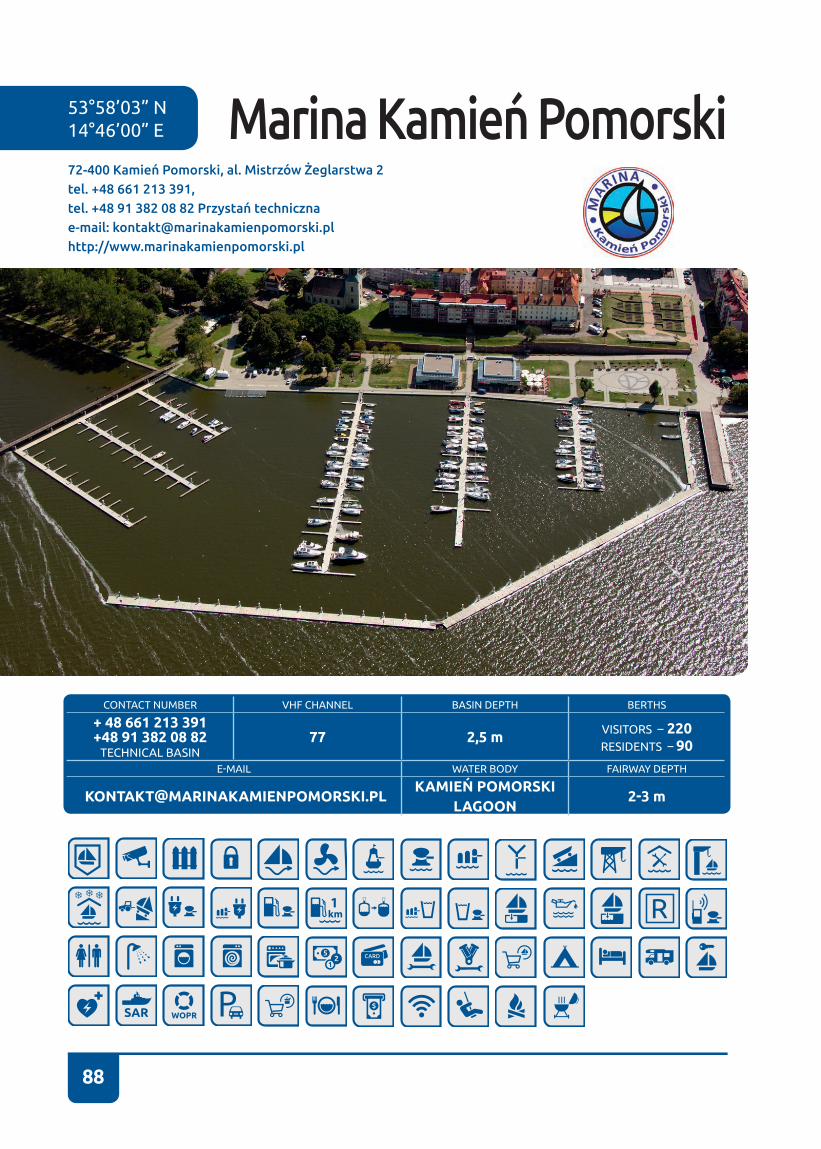
88
53°58’03” N 14°46’00” E
CONTACT NUMBER VHF CHANNEL BASIN DEPTH BERTHS
+ 48 661 213 391+48 91 382 08 82
TECHNICAL BASIN 77 2,5 m VISITORS – 220
RESIDENTS – 90
E-MAIL WATER BODY FAIRWAY DEPTH
[email protected]Ń POMORSKI
LAGOON 2-3 m
72-400 Kamień Pomorski, al. Mistrzów Żeglarstwa 2tel. +48 661 213 391, tel. +48 91 382 08 82 Przystań technicznae-mail: [email protected]://www.marinakamienpomorski.pl
Marina Kamień Pomorski

89
Kamień Pomorski is located between Wolin and Dziwnów. Waterways from Dziwnów and from Wolin feature no illumination� Sailing from Wolin, we pass the following bridges: one swing bridge and two per-manent bridges� Then we follow the wa-ter lane. In case of keel boats you need to remember about monitoring depth� We navigate along the Dziwna Strait� At buoys Nos 19 and 18 we sail round Chrząszczews-ka Island. We steer left, precisely towards the buoys - do not take any shortcuts. Then from buoy K3 we head east to buoy K2, from where we sail straight, steering at John the Baptist’s Cathedral� The marina is located between a pedestrian footbridge and a pier� The marina is sheltered by a floating landing. The entrance lies clos-er to the pedestrian footbridge crossing the Karpinka Bay. When approaching the entrance to the marina on-board a larger yacht, it is recommended to keep close to the breakwater when sailing from the pier.
The Technical Basin is situated immediate-ly behind an elevator in the southern part of the town� From the pier we head south along the shore, keeping about 60-meter distance from the shore, and we reach the Technical Basin. Entrance into the basin is located on the southern side� Directly after passing a red marina head, we make a tight
turn into the basin� The basin depth is ap-prox� 3 m�
In the Technical Basin there are two han-gars, a forklift for yacht lifting, a concrete slipway, along with a repair station and a place for yacht wintering�
Navigating from the direction of Dziwnów, we pass a vertical-lift bridge, sail around the area of a military unit, i.e. the Między-wodzki Peninsula. We enter the waters of Wrzosowskie Lake. On the right-hand side we pass concrete military installa-tions, immediately behind the installations a marked water lane begins (caution: it is shallow!), which ends with K1 buoy, from where we head south towards K2 buoy�
The Maritime Office in Szczecin specified the following permissible vessel draughts in the Dziwna Straight: 1. For the water lane section from the southern limit of Dz-iwnów port to K-1 buoy – 1.5 m. 2. For the water lane section from K-1 buoy to K-3 buoy – 1�7 m� 3� For the water lane section from K-3 buoy to the swing road bridge in Wolin – 1�2 m�
The above stipulation refers to average water level. Under keel clearance in the water lanes is 0�7 m� In practice, yachts
with a draught of 1.7 m enter Kamień Po-morski from the direction of Wolin, and with a draught of 2 m from the direction of Dziwnów. However, it all depends on the water level - the lower the water level, the smaller draught is permissible�
Kamień Pomorski
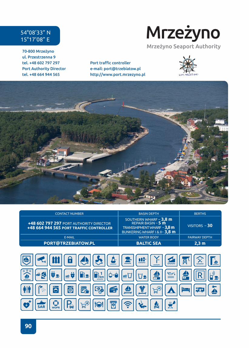
90
MrzeżynoMrzeżyno Seaport Authority
70-800 Mrzeżyno ul. Przestrzenna 9tel. +48 602 797 297 Port Authority Director tel. +48 664 944 565
Port traffic controllere-mail: [email protected]://www.port.mrzezyno.pl
54°08’33” N 15°17’08” E
CONTACT NUMBER BASIN DEPTH BERTHS
+48 602 797 297 PORT AUTHORITY DIRECTOR +48 664 944 565 PORT TRAFFIC CONTROLLER
SOUTHERN WHARF – 3,8 mREPAIR BASIN – 5 m
TRANSSHIPMENT WHARF – 3,8 mBUNKERING WHARF I & II– 3,8 m
VISITORS – 30
E-MAIL WATER BODY FAIRWAY DEPTH
[email protected] BALTIC SEA 2,3 m
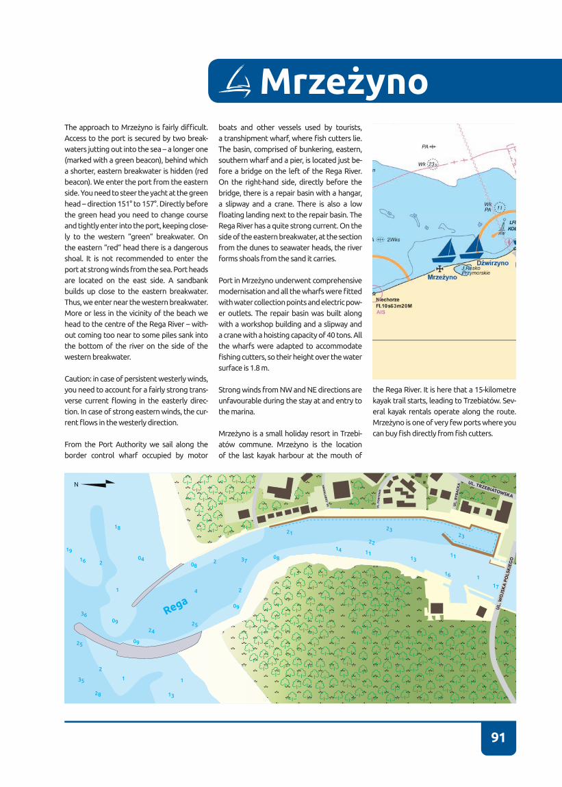
91
MrzeżynoThe approach to Mrzeżyno is fairly difficult. Access to the port is secured by two break-waters jutting out into the sea – a longer one (marked with a green beacon), behind which a shorter, eastern breakwater is hidden (red beacon)� We enter the port from the eastern side� You need to steer the yacht at the green head – direction 151° to 157°� Directly before the green head you need to change course and tightly enter into the port, keeping close-ly to the western “green“ breakwater. On the eastern “red“ head there is a dangerous shoal� It is not recommended to enter the port at strong winds from the sea� Port heads are located on the east side. A sandbank builds up close to the eastern breakwater. Thus, we enter near the western breakwater. More or less in the vicinity of the beach we head to the centre of the Rega River – with-out coming too near to some piles sank into the bottom of the river on the side of the western breakwater.
Caution: in case of persistent westerly winds, you need to account for a fairly strong trans-verse current flowing in the easterly direc-tion� In case of strong eastern winds, the cur-rent flows in the westerly direction.
From the Port Authority we sail along the border control wharf occupied by motor
boats and other vessels used by tourists, a transhipment wharf, where fish cutters lie. The basin, comprised of bunkering, eastern, southern wharf and a pier, is located just be-fore a bridge on the left of the Rega River� On the right-hand side, directly before the bridge, there is a repair basin with a hangar, a slipway and a crane� There is also a low floating landing next to the repair basin. The Rega River has a quite strong current. On the side of the eastern breakwater, at the section from the dunes to seawater heads, the river forms shoals from the sand it carries�
Port in Mrzeżyno underwent comprehensive modernisation and all the wharfs were fitted with water collection points and electric pow-er outlets� The repair basin was built along with a workshop building and a slipway and a crane with a hoisting capacity of 40 tons� All the wharfs were adapted to accommodate fishing cutters, so their height over the water surface is 1�8 m�
Strong winds from NW and NE directions are unfavourable during the stay at and entry to the marina�
Mrzeżyno is a small holiday resort in Trzebi-atów commune. Mrzeżyno is the location of the last kayak harbour at the mouth of
the Rega River. It is here that a 15-kilometre kayak trail starts, leading to Trzebiatów. Sev-eral kayak rentals operate along the route. Mrzeżyno is one of very few ports where you can buy fish directly from fish cutters.
17
16
1113
14 11
232321
0808
04
18
16
19
37
25
25
35
28 13
36
24
2
1 1
2
2
241
09
09
09
22
1
UL.
WO
JSK
A P
OLS
KIE
GO
UL. TRZEBIATOWSKA
UL.
RY
BA
CK
A
UL
. PO
RTO
WA
UL.
ZA
BY
TK
OW
A
Rega
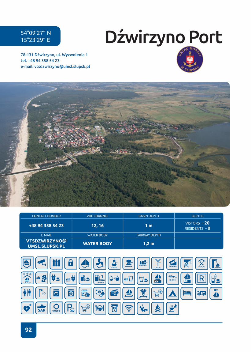
92
54°09’27” N 15°23’29” E
CONTACT NUMBER VHF CHANNEL BASIN DEPTH BERTHS
+48 94 358 54 23 12, 16 1 m VISTORS – 20RESIDENTS – 0
E-MAIL WATER BODY FAIRWAY DEPTH
[email protected] WATER BODY 1,2 m
78-131 Dźwirzyno, ul. Wyzwolenia 1tel. +48 94 358 54 23e-mail: [email protected]
Dźwirzyno Port

93
Dźwirzyno is a small port between Koło-brzeg (6 NM) and Mrzeżyno (4NM). Max-imum draught of the vessels calling here is 1�2 m, but it must be remembered that winds blowing from the land lower the water level by approx� 0�5 m�
Dźwirzyno has a smallish fishing port, in which “Omułek” dredger is permanently stationed, maintaining adequate depth of the basin as well as the basin entrance�
The port was built at the mouth of the Błotnica River flowing from Resko Pr-zymorskie Lake. Entrance to the port is located between two short breakwaters jutting perpendicularly out into the sea. On the approach to the port you need to assume the course of approx� 180�5°, steering at a double concrete pole stand-ing on the western shore of the canal near a road bridge, while keeping to the water lane axis�
At night you need to steer in a narrow white sector of DZWIRZYNO light (Krk 180° – 180�5°) leading to the centre of the port entry. Entry at night is particularly difficult. The entrance quickly accumu-lates slime (depth of approx� 1 m) when
unfavourable winds persist� The width be-tween breakwater heads is 19 m.
Caution! In case of persistent westerly winds, you need to account for a fairly strong transverse current flowing in the easterly direction� In case of strong east-ern winds, the current flows in the west-erly direction� Current speed may reach up to 3 knots!
The port boatswain works from Monday to Friday� Before entering port you need to ascertain with the boatswain as to the current depth� It is recommended to moor at the berthage basin on the left of the canal� We enter the basin near the boat-swain’s office, immediately before the bridge. Caution: in case of winds pushing towards land, leaving port may be diffi-cult�
Strong winds from N directions are unfa-vourable during the stay at and entry to the port. Caution: it is a very shallow port!!!
Dźwirzyno is a small holiday resort locat-ed between the Baltic Sea and Resko Pr-zymorskie Lake. There is a yacht harbour on Resko Lake, where you can rent rowing and paddling equipment – kayaks, rowing
Dźwirzyno
Kanał Restow
17
17
14 14
121213
13
23
23
23
23
22
22
27
27
25
25
32
33
34
34
33
31
27
24
24
26
26
26
28
14
1111
11
11
09
09
06
11
16
15
15
16
13
13
13
16
16
16
1218
17
25
21
UL. W
YZW
OLEN
IA
Morze Bałtyckie
boats, sailing yachts, and pedal boats� Re-sko Lake and a beautiful, nearly 60-m wide beach on the Baltic are undoubtedly ma-jor assets of the location. In the summer numerous cabarets perform in Dźwirzyno, and in July a 10-kilometre “Run to the Sun” is held�
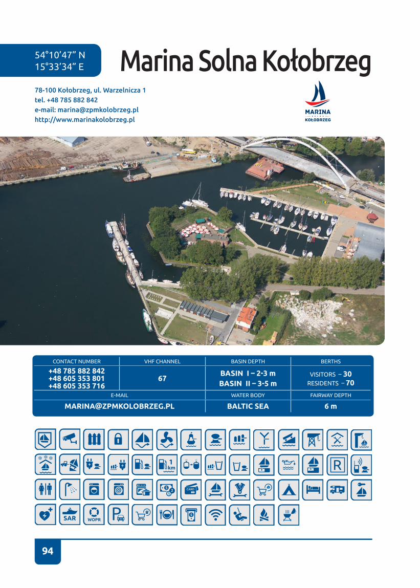
94
54°10’47” N 15°33’34” E
78-100 Kołobrzeg, ul. Warzelnicza 1tel. +48 785 882 842e-mail: [email protected]://www.marinakolobrzeg.pl
Marina Solna Kołobrzeg
CONTACT NUMBER VHF CHANNEL BASIN DEPTH BERTHS
+48 785 882 842+48 605 353 801+48 605 353 716
67BASIN I – 2-3 m BASIN II – 3-5 m
VISITORS – 30RESIDENTS – 70
E-MAIL WATER BODY FAIRWAY DEPTH
[email protected] BALTIC SEA 6 m
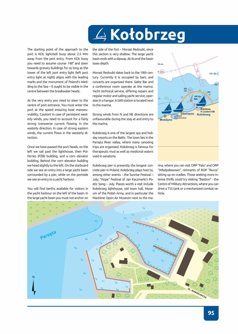
95
The starting point of the approach to the port is KOŁ light-bell buoy about 2.5 Mm away from the port entry. From KOŁ buoy you need to assume course 148° and steer towards granary buildings for as long as the tower of the left port entry light (left port entry light at night) aligns with the leading marks and the monument of Poland’s Wed-ding to the Sea – it ought to be visible in the centre between the breakwater heads.
At the very entry you need to steer to the centre of port entrance� You must enter the port at the speed ensuring boat manoeu-vrability. Caution! In case of persistent west-erly winds, you need to account for a fairly strong transverse current flowing in the easterly direction� In case of strong eastern winds, the current flows in the westerly di-rection�
Once we have passed the port heads, on the left we sail past the lighthouse, then Pol-ferries (PŻB) building, and a corn elevator building� Behind the corn elevator building we head slightly to the left� On the starboard side we see an entry into a large yacht basin surrounded by a pier, while on the portside we see an entry to a yacht harbour�
You will find berths available for visitors in the yacht harbour on the left of the basin� In the large yacht basin you must not anchor on
the side of the fort – Morast Redoubt, since this section is very shallow� The large yacht basin ends with a slipway� At its end the basin loses depth�
Morast Redoubt dates back to the 18th cen-tury� Currently it is occupied by bars, and concerts are organized there� Sailor Bar and a conference room operate at the marina� Yacht technical service, offering repairs and regular motor and sailing yacht service, oper-ates in a hangar� A SAR station is located next to the marina�
Strong winds from N and NE directions are unfavourable during the stay at and entry to the marina�
Kołobrzeg is one of the largest spa and holi-day resorts on the Baltic� The town lies in the Parsęta River valley, where many canoeing trips are organized. Kołobrzeg is famous for therapeutic mud as well as medicinal waters used in sanatoria�
Kołobrzeg pier is presently the longest con-crete pier in Poland. Kołobrzeg plays host to, among other events – the Sunrise Festival – July; “Hope“ Festival of Jan Kaczmarki’s Po-etic Song – July� Places worth a visit include Kołobrzeg lighthouse, old town hall, Muse-um of the Polish Army, and in particular the Maritime Open Air Museum next to the ma-
Kołobrzeg
rina, where you can visit ORP “Fala“ and ORP “Władysławowo“, remnants of ROP “Burza“ sitting up on cradles. Those seeking more in-tense thrills could try visiting “Bastion“ - the Centre of Military Attractions, where you can drive a T55 tank or a mechanized combat ve-hicle�
3131
32
34
27
63
522
27
21
14
1
2
2
2819
15
17
16
08
1515
11 16
18
49
48
41
38
57
3
3
3
3
Parsęt
a
UL. WARZELNICZA
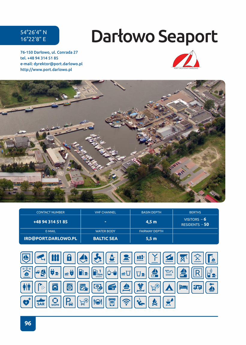
96
54°26’4” N16°22’8” E
CONTACT NUMBER VHF CHANNEL BASIN DEPTH BERTHS
+48 94 314 51 85 - 4,5 m VISITORS – 6RESIDENTS – 50
E-MAIL WATER BODY FAIRWAY DEPTH
[email protected] BALTIC SEA 5,5 m
76-150 Darłowo, ul. Conrada 27tel. +48 94 314 51 85e-mail: [email protected]://www.port.darlowo.pl
Darłowo Seaport
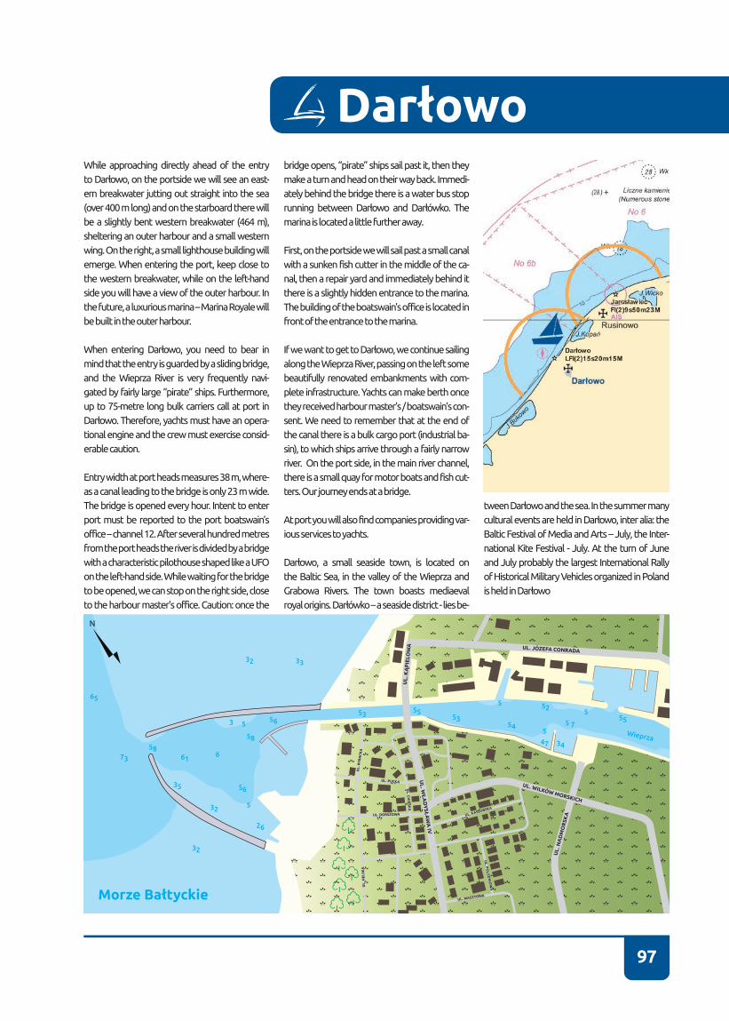
97
While approaching directly ahead of the entry to Darłowo, on the portside we will see an east-ern breakwater jutting out straight into the sea (over 400 m long) and on the starboard there will be a slightly bent western breakwater (464 m), sheltering an outer harbour and a small western wing� On the right, a small lighthouse building will emerge. When entering the port, keep close to the western breakwater, while on the left-hand side you will have a view of the outer harbour� In the future, a luxurious marina – Marina Royale will be built in the outer harbour�
When entering Darłowo, you need to bear in mind that the entry is guarded by a sliding bridge, and the Wieprza River is very frequently navi-gated by fairly large “pirate” ships. Furthermore, up to 75-metre long bulk carriers call at port in Darłowo. Therefore, yachts must have an opera-tional engine and the crew must exercise consid-erable caution�
Entry width at port heads measures 38 m, where-as a canal leading to the bridge is only 23 m wide� The bridge is opened every hour� Intent to enter port must be reported to the port boatswain’s office – channel 12� After several hundred metres from the port heads the river is divided by a bridge with a characteristic pilothouse shaped like a UFO on the left-hand side� While waiting for the bridge to be opened, we can stop on the right side, close to the harbour master’s office. Caution: once the
bridge opens, “pirate” ships sail past it, then they make a turn and head on their way back. Immedi-ately behind the bridge there is a water bus stop running between Darłowo and Darłówko. The marina is located a little further away�
First, on the portside we will sail past a small canal with a sunken fish cutter in the middle of the ca-nal, then a repair yard and immediately behind it there is a slightly hidden entrance to the marina� The building of the boatswain’s office is located in front of the entrance to the marina�
If we want to get to Darłowo, we continue sailing along the Wieprza River, passing on the left some beautifully renovated embankments with com-plete infrastructure. Yachts can make berth once they received harbour master’s / boatswain’s con-sent� We need to remember that at the end of the canal there is a bulk cargo port (industrial ba-sin), to which ships arrive through a fairly narrow river� On the port side, in the main river channel, there is a small quay for motor boats and fish cut-ters. Our journey ends at a bridge.
At port you will also find companies providing var-ious services to yachts�
Darłowo, a small seaside town, is located on the Baltic Sea, in the valley of the Wieprza and Grabowa Rivers� The town boasts mediaeval royal origins. Darłówko – a seaside district - lies be-
tween Darłowo and the sea. In the summer many cultural events are held in Darłowo, inter alia: the Baltic Festival of Media and Arts – July, the Inter-national Kite Festival - July� At the turn of June and July probably the largest International Rally of Historical Military Vehicles organized in Poland is held in Darłowo
Darłowo
Wieprza
65
73
5861
56
5653 53
5255
55
554
47
5 7
34
55
58
35
32
32
32
33
26
6
5
5
3
UL. JÓZEFA CONRADA
UL
. KĄ
PIE
LOW
A
UL
. WŁ
AD
YSŁ
AW
A IV
UL.
NA
DM
OR
SKA
UL. WILKÓW MORSKICH
UL
. RY
BA
CK
A
UL
. CH
IŃSK
A
UL. P
OLU
DN
IOW
A
UL. KASZUBSKA
UL. MASZTOWA
UL. DORSZOWA
UL. PUCKA
UL
. HE
LSK
A
Morze Bałtyckie
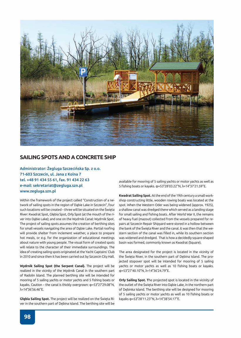
98
SAILING SPOTS AND A CONCRETE SHIP
Within the framework of the project called “Construction of a ne-twork of sailing spots in the region of Dąbie Lake in Szczecin”, four such locations will be created – three will be situated on the Święta River: Kwadrat Spot, Głębia Spot, Orły Spot (at the mouth of the ri-ver into Dąbie Lake); and one on the Wydrnik Canal: Wydrnik Spot. The project of sailing spots assumes the creation of berthing sites for small vessels navigating the area of Dąbie Lake. Partial roofing will provide shelter from inclement weather, a place to prepare hot meals, or e�g� for the organization of educational meetings about nature with young people� The visual form of created spots will relate to the character of their immediate surroundings� The idea of creating sailing spots originated at the Yacht Captains’ Club in 2010 and since then it has been carried out by Szczecin City Hall�
Wydrnik Sailing Spot (the Serpent Canal). The project will be realized in the vicinity of the Wydrnik Canal in the southern part of Radolin Island� The planned berthing site will be intended for mooring of 5 sailing yachts or motor yachts and 5 fishing boats or kayaks. Caution – the canal is thickly overgrown: φ=53°27’29.08”N, λ=14°36’56.46”E.
Głębia Sailing Spot. The project will be realized on the Święta Ri-ver in the southern part of Dębina Island. The berthing site will be
available for mooring of 5 sailing yachts or motor yachts as well as 5 fishing boats or kayaks. φ=53°28’03.22”N, λ=14°37’21.59”E.
Kwadrat Sailing Spot. At the end of the 19th century a small work-shop constructing little, wooden rowing boats was located at the spot� When the Western Oder was being widened (approx� 1925), a shallow canal was dredged there which served as a landing stage for small sailing and fishing boats. After World War II, the remains of heavy fuel (mazout) collected from the vessels prepared for re-pairs at Szczecin Repair Shipyard were stored in a hollow between the bank of the Święta River and the canal. It was then that the we-stern section of the canal was filled in, while its southern section was widened and dredged. That is how a decidedly square-shaped basin was formed, commonly known as Kwadrat (Square).
The area designated for the project is located in the vicinity of the Święta River, in the southern part of Dębina Island. The pro-jected stopover spot will be intended for mooring of 5 sailing yachts or motor yachts as well as 10 fishing boats or kayaks. φ=53°27’40.10”N, λ=14°36’24.79”E.
Orły Sailing Spot. The projected spot is located in the vicinity of the outlet of the Święta River into Dąbie Lake, in the northern part of Dębinka Island. The berthing site will be designed for mooring of 5 sailing yachts or motor yachts as well as 10 fishing boats or kayaks φ=53°28’11.23”N, λ=14°38’54.17”E.
Administrator: Żegluga Szczecińska Sp. z o.o.71-603 Szczecin, ul. Jana z Kolna 7tel. +48 91 434 55 61, fax. 91 434 22 63e-mail: [email protected]

99
Concrete ship. It is a hull of “Ulrich Finsterwalder” tanker which sank to the bottom of Dąbie Lake. The ship was built during Work War II in Darłowo. During the war the tanker carried synthetic pe-trol from a petrol plant in Police to Świnoujście. The ship measu-red 90 meters in length, 15 meters in width; it had 6.5 meters of draught and the internal volume of 2947 BRT� It was bombed on 20 March 1945 by the Soviet air force at Szczecin port�
After the war, the wreck was towed to Inoujście (mouth of the Ina River) and sunk there. At the turn of the 1970’s and 1980’s, at the
initiative of a divers’ association operating at Adolf Warski shipy-ard, the wreck was lifted and its transport to Dąbie was commen-ced, where it was meant to serve as a swimming pool� However, on account of soms technical issues the idea was abandoned and the ship was transported back to Inoujście, where it was grounded and turned into a tourist attraction. Each year musical concerts are held on-board the concrete ship, inter alia, “Jazz on the concrete ship”. The ship can also be observed while navigating the Oder in the direction of Świnoujście, when Babina Island is passed.
Za Wikipedia: http://pl.wikipedia.org/wiki/Ulrich_Finsterwalder
Materiały udostępnione przez Gminę Miasto Szczecin
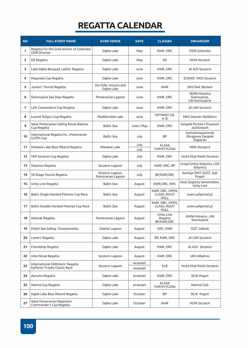
100
REGATTA CALENDAR
NO FULL EVENT NAME EVEN VENUE DATE CLASSES ORGANIZER
1 Regatta for the Gold Anchor of Goleniów OSiR Director Dąbie Lake May KWR, ORC OSiR Goleniów
2 DZ Regatta Dąbie Lake May DZ HOM Szczecin
3 Lake Dąbie Bouquet Ladies’ Regatta Dąbie Lake June KWR, ORC JK AZS Szczecin
4 Magnolia Cup Regatta Dąbie Lake June KWR, ORC ECEWiŻ MOS Szczecin
5 Juniors’ Tourist Regatta the Oder estuary and Dąbie Lake June KWR OKS Świt Skolwin
6 Świnoujście Sea Days Regatta Pomeranian Lagoon June KWR, ORCJKMW Kotwica
Świnoujście, UM Świnoujście
7 LOK Commodore Cup Regatta Dąbie Lake June KWR, ORC JK LOK Szczecin
8 Leonid Teliga’s Cup Regatta Myśliborskie Lake June OPTIMIST GR� A ,B MKS Szkuner Myślibórz
9 West Pomeranian Sailing Route Bakista Cup Regatta Baltic Sea June / May KWR, ORC Związek Portów i Przystani
Jachtowych
10 International Regatta for „Pomeranian Griffin Cup Baltic Sea July BP
Zachodniopomorski Okręgowy Związek
Żeglarski
11 Miedwie Lake Blue Riband Regatta Miedwie LakeJuly KLASA
TURYSTYCZNA MDK StargardJuly
12 YKP Szczecin Cup Regatta Dąbie Lake July KWR, ORC Yacht Klub Polski Szczecin
13 Stepnica Regatta Szczecin Lagoon July KWR, ORC, BP Urząd Gminy Stepnica, LOK Stepnica
14 50-Stage Tourist Regatta Szczecin Lagoon, Pomoranian Lagoon July BP,KWR,ORC Komisja ŻMiT ZOZŻ, Sejk
Pogoń
15 Unity Line Regatta Baltic Sea August KWR,ORC, NHC Klub Żeglarzy Samotników, Unity Line
16 Baltic Single Handed Polonez Cup Race Baltic Sea AugustKWR, ORC, OPEN,
CLASS, MULTI HULL
www�sailportal�pl
17 Baltic Double Handed Polonez Cup Race Baltic Sea AugustKWR, ORC, OPEN,
CLASS, MULTI HULL
www�sailportal�pl
18 Wiatrak Regatta Pomeranian Lagoon AugustUnity Line
Regatta BP,KWR,ORC
JKMW Kotwica , UM Świnoujście
19 Polish Sea Sailing Championship Gdańsk Lagoon August ORC, KWR OZŻ Gdańsk
20 Loners’ Regatta Dąbie Lake August BP, KWR, ORC JK LOK Szczecin
21 Friendship Regatta Dąbie Lake August KWR, ORC JK AZS Szczecin
22 Inter-Shoal Regatta Szczecin Lagoon August KWR, ORC UKS Albatros
23 International Oldtimers’ Regatta Epifanes Trophy Classic Race Szczecin Lagoon
wrzesieńKLR Yacht Klub Polski Szczecin
wrzesień
24 Autumn Regatta Dąbie Lake wrzesień KWR, ORC SEJK Pogoń
25 Marina Cup Regatta Dąbie Lake wrzesień KLASA TURYSTYCZNA Marina’Club
26 Dąbie Lake Blue Riband Regatta Dąbie Lake October BP SEJK Pogoń
27 West Pomeranian Regiment Commander’s Cup Regatta Dąbie Lake October KWR HOM Szczecin

101
Title:Sailing Directions for the West Pomeranian Sailing Trail
Authors: Kazimierz Olszanowski Jacek Łowiński Łukasz Olszanowski Bartosz Sawrymowicz Antoni Sobolewski
Consultations: Ryszard Szabela
English translation: Iwona Niedzielskia
Coordination: Katarzyna Jaroszewicz
Photographs: Konrad WielgoszewskiNasze Niebo Marek KrukielCezary Skórka
Publisher: Centrum Rozwoju Społeczno -Gospodarczego Przedsiębiorstwo Społeczne sp. z o.o. Organizacja Pożytku Publicznegoul. Marii Skłodowskiej -Curie 4, 71 -332 Szczecinwww�crsg�pl
Type-setting, printing: PPH ZAPOL Sobczyk sp.j.al. Piastów 42, 71 -062 Szczecinwww�zapol�com�pl
Ordered by: Związek Portów i Przystani Jachtowych – Lokalna Organizacja Turystyczna Zachodniopomorskiego Szlaku Żeglarskiegoal. Papieża Jana Pawła II 44/2, 70 -415 Szczecinwww�marinas�pl
ISBN:978 -83 -62229 -05-5 -
Publication and distribution free of charge Szczecin 2015
102

103
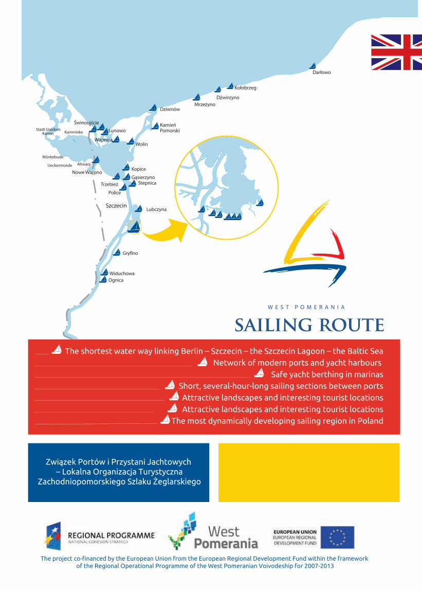
Z zek Portó
– L
The shortest water way linking Berlin – Szczecin – the Szczecin Lagoon – the Baltic Sea
Network of modern ports and yacht harbours
Safe yacht berthing in marinas
Short, several-hour-long sailing sections between ports
Attractive landscapes and interesting tourist locations
Attractive landscapes and interesting tourist locations
The most dynamically developing sailing region in Poland