B A B E S C H · Gilbert Wiplinger (Österreichisches Archäologisches Institut, Vienna) De...
48
BABESCH Byvanck Lecture 2019 B A B E S C H irteenth BABESCH Byvanck Lecture Gilbert Wiplinger De aquaeductu urbis Ephesi Water for Roman Ephesus Tuesday November 26 th 2019 at the National Museum of Antiquities at Leiden e BABESCH Foundation
Transcript of B A B E S C H · Gilbert Wiplinger (Österreichisches Archäologisches Institut, Vienna) De...
BABESCH Byvanck Lecture 2019
B A B E S C HThirteenth BABESCH Byvanck Lecture
Gilbert WiplingerDe aquaeductu urbis Ephesi
Water for Roman Ephesus
Tuesday November 26th 2019at the National Museum of Antiquities at Leiden
e BABESCH Foundation


De aquaeductu urbis EphesiWater for Roman Ephesus
irteenth BABESCH Byvanck Lecture

De aquaeductu urbis EphesiWater for Roman Ephesus
Gilbert WiplingerÖsterreichisches Archäologisches Institut, Vienna
e BABESCH Foundation
Leiden
2019

Colophon
© 2019 Gilbert Wiplinger and the BABESCH Foundation
Editor: Vanessa Boschloos
BABESCHEmail: [email protected] Website: https://www.babesch.org
e rise of BABESCH to an established forum for international scholarly exchange has been due in no small part to the tireless efforts of the late dr. Lily Byvanck-Quarles van Ufford (1907-2002). Her passionate involvement continues through the substantial endowment she made to Leiden University in the form of the Byvanck Fund, with the BABESCH Foundation explicitly labelled as one of the beneficiaries. is has enabled the Foundation to develop, aside its scholarly publishing duties, various other activities geared to a wider community, of which the Byvanck Lecture series is the best known. Another initiative perpetuating Lily’s name is the Byvanck Award for the best contribution of a young, debutant scholar in the BABESCH journal. A fairly recent addition is the publication of the annual Byvanck Lecture in a booklet.
Lay-out: Rogier A.A. KalkersPrinted by Mirto, Ghent
No part of this publication may be translated or reproduced in any form, by print, photo-print, microfilm, or any other means, without written permission from the publisher.
ISBN 978 94 929 4497 9Wettelijk depot: D/2019/3988/66
NUR 680 – 683
B A B E S C HFoundation


The BABESCH Byvanck Lecture Series
November 26th 2019
Gilbert Wiplinger (Österreichisches Archäologisches Institut, Vienna)De aquaeductu urbis Ephesi: Water for Roman Ephesus
December 4th 2018Eric M. Moormann (Radboud University, Nijmegen)
The impact of Winckelmann on Europe
November 28th 2017Roger J.A. Wilson (University of British Columbia, Vancouver)
Dining with the dead in early Byzantine Sicily: Excavations at Punta Secca near Ragusa
November 29th 2016Guy D. R. Sanders (American School of Classical Studies at Athens)
Recent Finds from Ancient Corinth: How Little Things Make Big Differences
December 15th 2015Olga Palagia (University of Athens)
The Impact of Alexander the Great on the Arts of Greece
November 25th 2014Lawrence Stager (Harvard University, Cambridge)
Rites of Spring in the Carthaginian Tophet
November 19th 2013Susan Alcock (Brown University, Providence)
What to do with a Wonder of the World: The Puzzle of Jordan
November 20th 2012Dyfri Williams (British Museum, London)
Up Close and Personal: A New View of the Parthenon’s East Pediment
November 1st 2011Maria Bonghi Jovino (Università degli Studi di Milano)
The Archaic Temples of the Etruscans

November 16th 2010Andrew Wallace-Hadrill (University of Cambridge)
Herculaneum: Living with Catastrophe
November 24th 2009Cemal Pulak (Texas A&M University, College Station)
The Uluburun Shipwreck and Late Bronze Age Maritime Tradein the Eastern Mediterranean
December 15th 2008Simon Keay (University of Southampton)
Rediscovering Portus: The Port of Imperial Rome
October 26th 2007Alexandros Mazarakis Ainian (University of essaly, Volos)Inside the Adyton of a Greek Temple: Excavations at Kythnos

1
De aquaeductu urbis EphesiWater for Roman Ephesus
Abstract
With the 2004 conference “Cura aquarum in Ephesus”, the ongoing series of international congresses on the history of water management and hydraulic engineering in the Mediterranean Region was continued with the aim of placing the newly started aqueduct research in the metropole of the Roman province Asiae on an international discussion platform. This and three other symposia were published in the BABESCH Supplements series and the interdisciplinary research project at the Değirmendere aqueduct at Ephesus was advanced in parallel.
The development of the city of Ephesus is reflected in its water supply. When Lysimachus built the city on a new site at the beginning of the 3rd century BC, a simple clay pipe line from a nearby spring was sufficient. It was not until the city’s heyday in the first quarter of the 2nd century AD that channels were built under Trajan and Hadrian in order to supply large quantities of water from springs further away to the rapidly growing population with their luxurious baths, magnificent fountains and well equipped houses.
The exploration of the 36.5 km long Değirmendere aqueduct was a special challenge. Water was transported over 24 bridges and through four tunnels. The first channel was constructed in Hadrian times and allowed transporting a water volume of 21,000 m3 per day. After 30-35 years of operation, the small channel was torn apart by 3 m during an earthquake. This necessitated the construction of a new aqueduct at the end of the Antonine period. This aqueduct was given a larger cross-section and thus 50,000 m3 per day could be transported into the city. During its operating time up to the third quarter of the 4th century AD, many repairs were necessary, especially on the steep slopes and in the extremely flat channel. On the one hand, the slope pressure was absorbed by supporting buttress pillars attached to the channel, and on the other hand, many bypasses were necessary to avoid overflows.
The results of this new research are manifold and fascinating.

2
Sextus Iulius Frontinus, in his capacity as supreme curator aquarum of Rome at the turn of the 1st to the 2nd century AD, wrote in his book “De aquaeductu urbis Romae”, from which we learned a great amount about the long-distance water supply lines existing in his time, about their construction, maintenance and about the laws enacted to protect them and a lot of other things. Today I will introduce the aqueducts of Ephesus under this topic, following his writing.
THE BEGINNING AT THE END POINT OF THE WATER
I would like to start with my personal approach to this topic, because I first dealt with the use of water in the luxury apartments of Ephesus, especially with the living units 1 and 2 of the Terrace House 2 (fig. 1). Water reached each apartment in a single, separate pipeline and was led to the individual fountains, into the kitchen rooms, the latrines and partly also to small private baths. It was a confusing system of clay pipes from where it was collected again in small, masonry canals and was diverted in the large, accessible main canals under the stairways bordering the insula. As an example, let us take a look at a small, mar-ble-plated niche nymphaeum in the triclinium of living unit 2, the apsis of which was decorated with a figurative glass mosaic (fig. 2). e front panel is missing
Fig. 1: Terrace House 2, living unit 1 and 2: light blue = water supply lines (pipes), dark blue = water intake point (fountains, baths, kitchen, latrines), dark red = channels, sewers, light red = courtyards (impluvia).

3
today, but in the semi-circular niches from top to bottom you can see the water outlet, the overflow and the outlet for emptying. To the left one gets a view through the door into the peristyle, in the middle of which another three-limbed floor nymphaeum was arranged – not visible on the figure – whose overflowing water moistened the marble decorated floor in the impluvium and thus provided pleasant room cooling. is overflow water and also the rainwater from the roof were collected and drained in a gutter running around the edge of the impluvium.
My interest in aqueducts was awakened through this work, because I wanted to know where the water came from and how it was led into the city. And so I fol-lowed in the footsteps of Philipp Forchheimer, who in 1898, three years after the Austrian excavations in Ephesus had begun, studied the first long-distance aque-ducts during a stay of about one month. So after 25 years work in the Terrace Houses, I went out to the springs from 2001 to 2011 with an international and interdisciplinary team, including four scientists from the Netherlands, to discover interesting things about these long distance aqueducts bringing water into the city. But before going into more detail about the longest and youngest Değirmen-dere aqueduct, we will get a brief overview of all the long-distance water supply lines that have been built in this metropolis of the Roman province of Asiae.
Fig. 2: Marble niche as fountain in the triclinium SR 24 of living unit 2 at Terrace House 2 with view through the door into the peristyle.
4
THE SERIES OF CONFERENCES
In order to place this work on a broad platform of specialists and scientists from the very beginning, an international conference titled “Cura aquarum in Ephesus” was organised in 2004 in Turkey, at which the previous research results were presented and discussed in detail. is conference was the 12th in a series of congresses on the history of ancient water management and hydraulic engineer-ing in the Mediterranean region.
e Ephesus team first prepared an instructional booklet in which guidelines for the documentation, study, research and evaluation of the aqueducts were established after which each team member had to orientate himself with this standardized methodology of the project work as far as possible. In addition to the research work, further conferences were organised in order to exchange and discuss our experiences with colleagues and we presented our new results each time so that constant feedback from the experts would also guarantee an optimal project result.
In 2011, the next conference took place in Vienna (Austria) under the title “His-torische Wasserleitungen. Gestern - Heute - Morgen”, “De aqueductu atque aqua urbium Lyciae Pamphyliae Pisidiae. e Legacy of Sextus Iulius Frontinus” was the name of the next event in 2014 in Antalya (Turkey). “Wasserwesen zur Zeit des Frontinus. Bauwerke - Technik - Kultur” was the title of the 4th symposium held 2016 in Trier (Germany), and most recently “De aquaeductu urbis Romae. Sextus Iulius Frontinus and the Water of Rome” in 2018 in Rome (Italy). An essential part of these events were the excursions to the hydraulic structures of the surrounding areas in order to be able to study many objects and comparative examples for our work and for the participants to achieve the greatest possi-ble scientific benefit. anks to BABESCH, the proceedings were published in the BABESCH Supplement volumes 12, 24, 27 and 32, whereby the publica-tion of the Rome-conference is now in progress and as a highlight, namely our research at the Değirmendere Aqueduct of Ephesus, appeared in the supple-ment volume 36 just last June. us the supplement volumes of BABESCH have also become a publication platform of the international Frontinus Society.

5
THE AQUEDUCTS OF EPHESUS
I would like to mention here that the oldest remains of a water pipe is a huge string of lead pipe with stone cuffs from the 5th or 4th century BC that was found in the area of the Temple of Artemis which is considered one of the Seven Wonders of the Ancient World (fig. 3). e design of the pipe as a pressure line makes no sense at this deepest part of the area, as it no longer had to be trans-ported upwards. I had therefore already expressed the suspicion previously that such an execution of the pipeline must have been seen as a ritual purpose, either to use the water to clean the courtyard area after the slaughtering of the sacrifices or even to drain off the sacrifices’ blood.
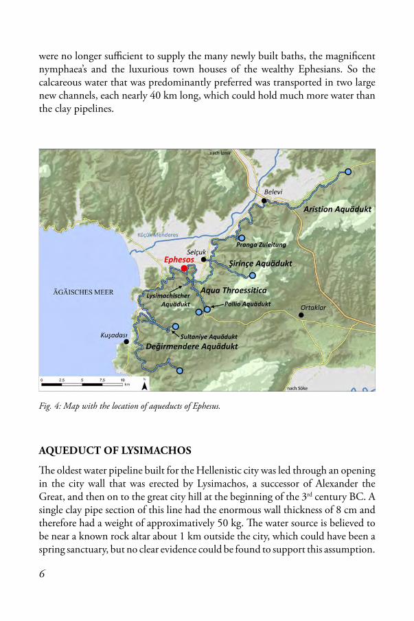
In the following chronological list of the Ephesian long-distance water supply lines, a close connection between the aqueducts and the development of the city can be immediately noticed (fig. 4). While in Hellenistic and early Roman times only a single clay pipe line was sufficient at first, more and more lines combined into a single supply system, while more and more water had to be collected from springs further and further away as the population increased and fed into the growing city. At the beginning of the 2nd century AD, when Ephesus reached its heyday under the emperors Trajan and Hadrian, the small clay pipe lines
Fig. 3: Lead pipes with stone cuffs in the Artemis temple.
6
were no longer sufficient to supply the many newly built baths, the magnificent nymphaea’s and the luxurious town houses of the wealthy Ephesians. So the calcareous water that was predominantly preferred was transported in two large new channels, each nearly 40 km long, which could hold much more water than the clay pipelines.
AQUEDUCT OF LYSIMACHOS
e oldest water pipeline built for the Hellenistic city was led through an opening in the city wall that was erected by Lysimachos, a successor of Alexander the Great, and then on to the great city hill at the beginning of the 3rd century BC. A single clay pipe section of this line had the enormous wall thickness of 8 cm and therefore had a weight of approximatively 50 kg. e water source is believed to be near a known rock altar about 1 km outside the city, which could have been a spring sanctuary, but no clear evidence could be found to support this assumption.
Fig. 4: Map with the location of aqueducts of Ephesus.
7
AQUA THROESSITICA AND THE POLLIO AQUEDUCT
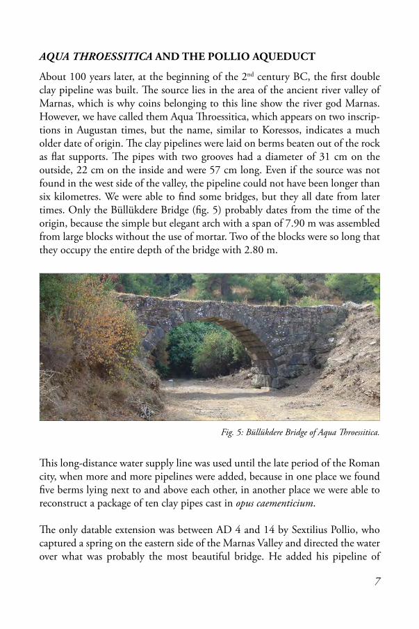
About 100 years later, at the beginning of the 2nd century BC, the first double clay pipeline was built. e source lies in the area of the ancient river valley of Marnas, which is why coins belonging to this line show the river god Marnas. However, we have called them Aqua roessitica, which appears on two inscrip-tions in Augustan times, but the name, similar to Koressos, indicates a much older date of origin. e clay pipelines were laid on berms beaten out of the rock as flat supports. e pipes with two grooves had a diameter of 31 cm on the outside, 22 cm on the inside and were 57 cm long. Even if the source was not found in the west side of the valley, the pipeline could not have been longer than six kilometres. We were able to find some bridges, but they all date from later times. Only the Büllükdere Bridge (fig. 5) probably dates from the time of the origin, because the simple but elegant arch with a span of 7.90 m was assembled from large blocks without the use of mortar. Two of the blocks were so long that they occupy the entire depth of the bridge with 2.80 m.
is long-distance water supply line was used until the late period of the Roman city, when more and more pipelines were added, because in one place we found five berms lying next to and above each other, in another place we were able to reconstruct a package of ten clay pipes cast in opus caementicium.
e only datable extension was between AD 4 and 14 by Sextilius Pollio, who captured a spring on the eastern side of the Marnas Valley and directed the water over what was probably the most beautiful bridge. He added his pipeline of
Fig. 5: Büllükdere Bridge of Aqua Throessitica.
8
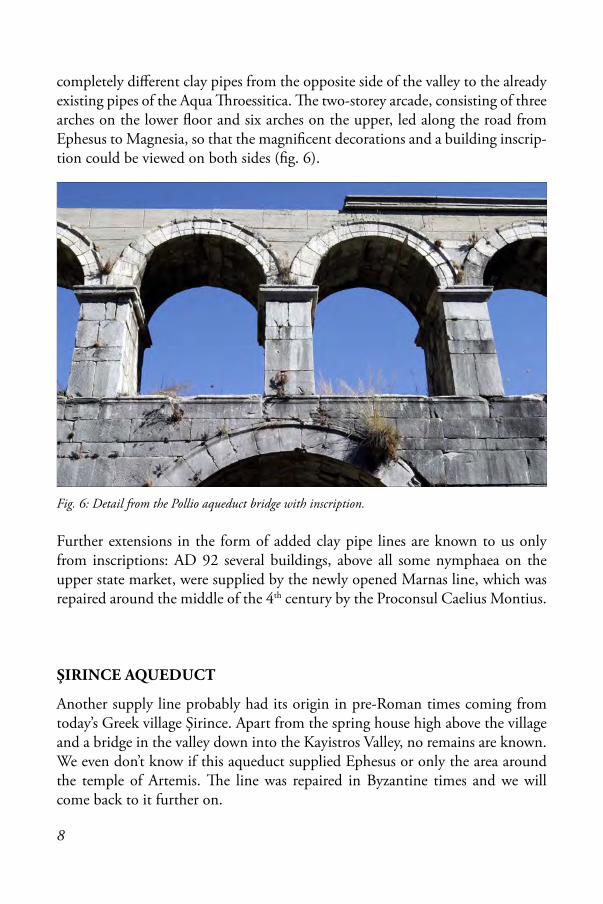
completely different clay pipes from the opposite side of the valley to the already existing pipes of the Aqua roessitica. e two-storey arcade, consisting of three arches on the lower floor and six arches on the upper, led along the road from Ephesus to Magnesia, so that the magnificent decorations and a building inscrip-tion could be viewed on both sides (fig. 6).
Further extensions in the form of added clay pipe lines are known to us only from inscriptions: AD 92 several buildings, above all some nymphaea on the upper state market, were supplied by the newly opened Marnas line, which was repaired around the middle of the 4th century by the Proconsul Caelius Montius.
ŞIRINCE AQUEDUCT
Another supply line probably had its origin in pre-Roman times coming from today’s Greek village Şirince. Apart from the spring house high above the village and a bridge in the valley down into the Kayistros Valley, no remains are known. We even don’t know if this aqueduct supplied Ephesus or only the area around the temple of Artemis. e line was repaired in Byzantine times and we will come back to it further on.
Fig. 6: Detail from the Pollio aqueduct bridge with inscription.

9
AQUA IULIA
From an inscription we know of the Aqua Iulia, another long-distance water pipeline from the Augustan period. In the past it was equated with the Değir-mendere aqueduct, but this cannot be due to its new dating. However, it could be a predecessor of the Değirmendere aqueduct, because a clay pipeline led from a source in the village of Sultaniye, of which Roman remains of a spring building are still preserved, toward the coast in a westerly direction. On the way, the two-storey Kelebek Bridge is a construction that can be dated back to this period due to its precise construction using a modulus (fig. 7). In the further course parallel to the coast going to Ephesus, high above the Değirmendere aqueduct, especially in the modern forest firebreaks, a disturbed clay pipeline and another aqueduct bridge of similar construction could be found, but we did not have the possibility to pursue this aqueduct further.
ARISTION AQUEDUCT
Under the Emperor Trajan, the city experienced a real construction boom and the demand for water increased sharply. erefore, all previous clay pipe-lines could no longer supply the city’s needs. From the building inscriptions we know that Claudius Aristion – a well-known resident of Ephesus – had built the first channel and its end point, the magnificent nymphaeum of Emperor Trajan on the Kuretes Street in the centre of Ephesus before AD 113. According to this inscription, the line was 210 stadiums (approximatively 38 km) long. It was derived from a spring in the Kayistros Valley, located north-east of the city, however the remains have disappeared as far as the point where water was led to the back side of the Hellenistic mausoleum of Belevi.
Fig. 7: Remains of the Kelebek Bridge of Aqua Iulia.
10
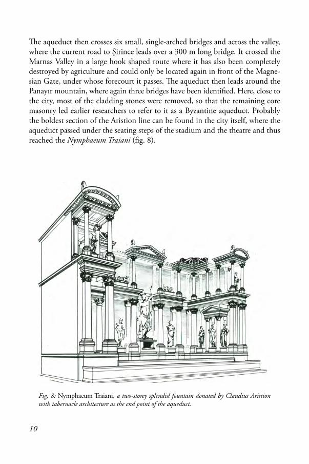
e aqueduct then crosses six small, single-arched bridges and across the valley, where the current road to Şirince leads over a 300 m long bridge. It crossed the Marnas Valley in a large hook shaped route where it has also been completely destroyed by agriculture and could only be located again in front of the Magne-sian Gate, under whose forecourt it passes. e aqueduct then leads around the Panayır mountain, where again three bridges have been identified. Here, close to the city, most of the cladding stones were removed, so that the remaining core masonry led earlier researchers to refer to it as a Byzantine aqueduct. Probably the boldest section of the Aristion line can be found in the city itself, where the aqueduct passed under the seating steps of the stadium and the theatre and thus reached the Nymphaeum Traiani (fig. 8).
Fig. 8: Nymphaeum Traiani, a two-storey splendid fountain donated by Claudius Aristion with tabernacle architecture as the end point of the aqueduct.

11
e channel along the aqueduct route consists of an approximatively 1.90 m wide trench, carefully cut out of the rock; the height of which can be up to 2.50 m on the uphill side and up to 1.20 m on the downhill side, if necessary at all (fig. 9). e two side walls of the channel made of quarry stones were built in this trench, leaving an average width of 1.05 m for the channel. e ceiling was formed by a quarry stone vault. e height of 1.40 m at the cross-section from the floor to the apex of the vault could be measured at two preserved points. e walls and the bottom of the channel were plastered with opus signinum.
As we discovered only later, the Nymphaeum Traiani was not the end point of the aqueduct because in the east of the elongated scoop basin, a channel leads under-ground, parallel and uphill to the Kuretes Street. It crosses at a suitable place after a bend to the south, in order to reappear in the two Terrace House-insulae. But only Gaius Flavius Furius Aptus, as Dionysus priest and agora nomen, had enough influence to obtain the permission to drain the water for three fountain basins in his state rooms, which served the cult of Dionysus (fig. 10). e end-point of this continuation of the Aristion aqueduct was certainly the port, where the water was used by the craftsmen’s establishments, which were located there.
Fig. 9: Cross section of the Aristion aqueduct.

12
Shortly after this aqueduct was put into operation, its preservation was already shown to be in danger when Proconsul Martialis enacted a law in 113/114 order-ing the observance of a 10-foot-wide protective strip on both sides of the aque-duct under threat of a very heavy monetary penalty. Only six years later Proconsul Priscus again engraved an inscription on the same stone, repeating the text of the law, as the population did not seem to be deterred by the threat of punishment. On these inscriptions are also mentioned the names of the supervisors of the water supply of Ephesus – colleagues of the former curator aquarum Frontinus.
Fig. 10: Floor water basin and niche-fountain in the marble hall 31 of living unit 6 of Terrace House 2.

13
DEĞIRMENDERE AQUEDUCT
e Değirmendere aqueduct is the last and longest long-distance water pipeline built for the Roman city (fig. 11). It approaches the coast east of the tourist metropolis Kuşadası and supplies Ephesus with water from the south. Due to the enormous and rapid spread of Kuşadası from a former small fishing village to a tourist centre, the extension of the coastal road and the intensive agricul-tural use of the fertile valleys, the ancient aqueduct was endangered. From 2006 onwards we concentrated our work only on this aqueduct, which we recorded and documented in detail in a three-year project of the Austrian Science Fund. e work and infinite amount of data available was finally made public in the Değirmendere publication published six months ago. For this reason, this is the best researched aqueduct of Ephesus and it was interesting to observe how, day by day, new insights were gained that led to a completely different result than previously known. In the beginning it was only known that there were two dif-ferent lines in a certain section and that its building originated approximatively from the middle of the 2nd century AD – not much more. rough our work we now know an entirely different picture.
Hadrian Aqueduct
e first building phase was constructed in Hadrian times between AD 123 and 127 and fresh water from the spring was brought over at least 24 bridges and through four tunnels for a total length of 37.5 km into the city. Due to its geographical location in the landscape, the aqueduct can be divided into three large zones. e division into sections was carried out independently of these zones from the source to the city, and from aqueduct bridge to aqueduct bridge. In the first zone, from the source to the northern end of Kuşadası, the construc-tion of which has almost completely destroyed within the last 20 years in the city, the aqueduct is underground because of the flat terrain and therefore only the remains of the aqueduct bridges and the access shafts to the tunnels can be seen on the surface. e geological situation of the area is very different from that of the other zones, as the channel had to be placed in Neogene clay layers and was therefore very susceptible to destruction and often had to be repaired. e boundary between this first zone and the next is the İçmetepe fault line.
In the second zone, the now double-guided aqueduct lies high above the sea on a slope and is clearly visible from afar with its quarries. It begins immediately to the north of Kuşadası and ends at the Mezarlık tunnel. It goes far into the

14
Fig. 11: Map with the location of the Değirmendere aqueduct.
15
Bahçecikboğaz Valley and crosses it with a siphon bridge, which also forms the boundary of the two completely different areas of the double line concerning their location. Here it is built into the more stable rock layers of the marble ridge.
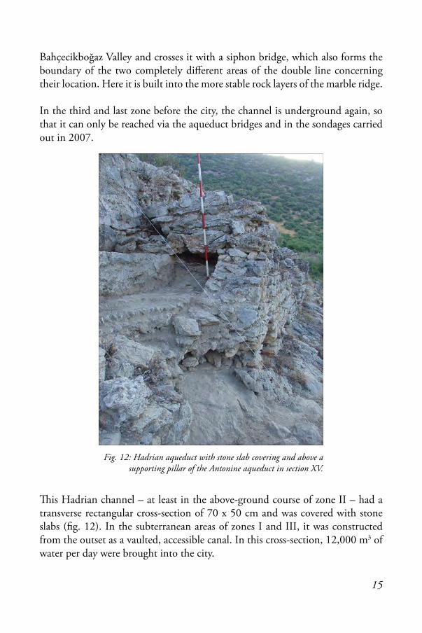
In the third and last zone before the city, the channel is underground again, so that it can only be reached via the aqueduct bridges and in the sondages carried out in 2007.
is Hadrian channel – at least in the above-ground course of zone II – had a transverse rectangular cross-section of 70 x 50 cm and was covered with stone slabs (fig. 12). In the subterranean areas of zones I and III, it was constructed from the outset as a vaulted, accessible canal. In this cross-section, 12,000 m3 of water per day were brought into the city.
Fig. 12: Hadrian aqueduct with stone slab covering and above a supporting pillar of the Antonine aqueduct in section XV.

16
Antonine aqueduct
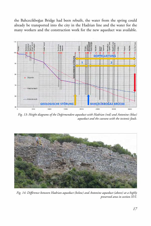
32 to 36 years later, during an earthquake in which the Neogene clay layers including the aqueduct at the İçmetepe fault sank by 3 m, an almost complete new construction of the channel became necessary. e geologists were able to determine the time span due to the relatively small sequence of layers of the sinter deposits in the channel. e earthquake can be dated to the year AD 159 due to an inscription from the emperor found in 2013, which was secondarily used in the late antique residence built into the Verulanus hall which was connected to the huge Harbour Baths. Due to the rapid increase of the population of Ephesus and the construction of ever larger baths and even more magnificent fountains, the amount of water transported in the Hadrian channel was no longer sufficient and the much more productive Keltepe springs were captured and fed into the aqueduct. So the cross-section in Zone II also had to be enlarged, since 50,000 m3 of water per day – four times as much as before – could now be brought into the city in the Antonine aqueduct.
e channel was built three metres deeper at the fault and with a much lower gradient, so that it reached the level of the older channel again at the Bahçecik-boğaz Bridge. Since the aqueduct was already out of operation in this area during the new construction, the Ephesians decided to build a new line. It not only had a larger cross-section but also a lower gradient from the Bahçecikboğz Bridge towards the city, so that higher areas of the city could be supplied. is younger line arrives 8.0 m higher in the city than the older one (fig. 13). is also clari-fied the puzzling fact that on the southern slope of the Bahçecikboğz Valley the Hadrian line is higher than the Antonine line, while on the northern slope it is exactly the opposite.
e new channel, measuring up to approximatively 0.85 x 2.35 m, was pro-vided with a stone vault and was now also easily accessible in zone II. But why were the bridges of the Antonine aqueduct in zone II, with the exception of the three large constructions of the Bahçecikboğaz, Mercankuyu and Arvalyaçeşme Bridges, always rebuilt and in almost all cases directly attached to the Hadrian bridges? It would have been much more time- and cost-saving if the new channel had been routed over the existing bridges, as these only had to be built up: at the beginning of the Adamtoluboğaz Bridge only 88 cm high and at the Taşkesinti Bridge up to 2.10 m. e only reasonable explanation is related to the fact that the aim was to keep the period of interruption of the water flow into the city after the earthquake as short as possible: after the section from the fault line to
17
the Bahcecikboğaz Bridge had been rebuilt, the water from the spring could already be transported into the city in the Hadrian line and the water for the many workers and the construction work for the new aqueduct was available.
Fig. 13: Height diagrams of the Değirmendere aqueduct with Hadrian (red) and Antonine (blue) aqueduct and the caesura with the tectonic fault.
Fig. 14: Difference between Hadrian aqueduct (below) and Antonine aqueduct (above) at a highly preserved area in section XVI.

18
Different types of masonry and their connection with quarries
From the beginning of the research on the Değirmendere aqueduct, the different quality of planning and execution between the Hadrian and Antonine aqueduct was noticeable. e Hadrian line is characterized by a very careful wall construc-tion. is can be seen particularly clearly in a highly preserved area in section XVI (fig. 14). In addition, it was even possible to determine a colour design by emphasising the level of the sole structure on the outer façade with darker stones in two layers, which for the first time made it possible to recognise an aesthetic element in the purely functional aqueduct. In section XVIII in particular, nine different types of masonry were defined for the Hadrian aqueduct, which can be distinguished primarily on the basis of structural features in the construction of the substructure.
However, the masonry of the Antonine channel, which had to be built under great time pressure, is completely different (fig. 15). It no longer achieved the
Fig. 15: Masonry type AA of the Antonine aqueduct in section XV.

19
care of the older aqueduct. However, this is understandable when one considers that the approximatively 30 years of water supply from this aqueduct was now interrupted. Here much smaller quarry stones were laid in rows and separated from each other by levelling layers of thin stones. Seven types of masonry were also found in the Antonine aqueduct, but here they were not just distinguished according to constructive features. With three of the types, a direct connection with the quarries located at the route clearly showed up. ese are already known types of masonry, which, however, show clearly different appearances from the basic types due to the use of other stone materials. ereby also the connection between the quarries found largely above the line and the masonry type used becomes clear, they used the directly above existing rock with the construction of the Antonine aqueduct, in order to avoid longer transport ways from the outset and to save time with it.
Aqueduct bridges
Most aqueduct bridges are very simple, single arch constructions that span only a small valley. A good example is the well-preserved Adamtoluboğaz Bridge (fig. 16). In zone II, the Hadrian and Antonine constructions are also built directly next to each other. Multi-arch bridges spanning large and wide valleys are much rarer. e longest is the Arvalya Bridge in zone III with a length of 386 m, which was however only 4.77 m high; the highest bridge is the Sabancık Bridge in zone I with a height of 20.62 m and a length of 222 m. In zone II there are two bridges so big that it would have been too much effort to put the Antonine bridge next to the Hadrian one but here individual solutions were found.
Fig. 16: Adamtoluboğaz Bridge.

20
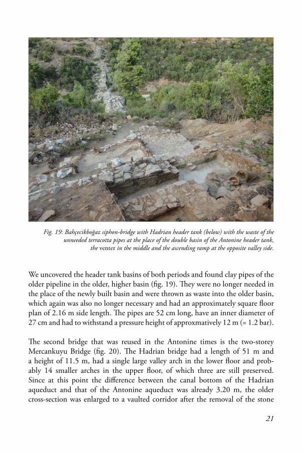
e large Bahçecikboğaz Valley is crossed with a pressure pipeline – a so-called siphon – otherwise a 128 m long and 23.5 m high bridge would have been necessary, which would have been exposed to enormous wind pressure in the narrow valley (fig. 17). For this reason, a smaller bridge had already been built on the valley bottom in the Hadrian time – the Roman architect Vitruvius calls it a venter in his ten books on architecture. It is 54 m long and 11.5 m high, consists of a large valley passage arch, at least four smaller arches in the south, which are missing in the north due to the steeper terrain (fig. 18). e core masonry of opus caementicium is covered with beautifully grooved marble ashlars. A clay pipeline was laid over this bridge. e bridge could be reused in the Antonine times without any changes. Due to only slight differences in height between the older and the new pipeline, a new header tank was built.
Fig. 17: Bahçecikboğaz-siphon-bridge to the left the Hadrian and Antonine channel in section XIV.
Fig. 18: Bahçecikboğaz siphon-bridge, reconstruction.
21
We uncovered the header tank basins of both periods and found clay pipes of the older pipeline in the older, higher basin (fig. 19). ey were no longer needed in the place of the newly built basin and were thrown as waste into the older basin, which again was also no longer necessary and had an approximately square floor plan of 2.16 m side length. e pipes are 52 cm long, have an inner diameter of 27 cm and had to withstand a pressure height of approxmatively 12 m (= 1.2 bar).
e second bridge that was reused in the Antonine times is the two-storey Mercankuyu Bridge (fig. 20). e Hadrian bridge had a length of 51 m and a height of 11.5 m, had a single large valley arch in the lower floor and prob-ably 14 smaller arches in the upper floor, of which three are still preserved. Since at this point the difference between the canal bottom of the Hadrian aqueduct and that of the Antonine aqueduct was already 3.20 m, the older cross-section was enlarged to a vaulted corridor after the removal of the stone
Fig. 19: Bahçecikboğaz siphon-bridge with Hadrian header tank (below) with the waste of the unneeded terracotta pipes at the place of the double basin of the Antonine header tank,
the venter in the middle and the ascending ramp at the opposite valley side.
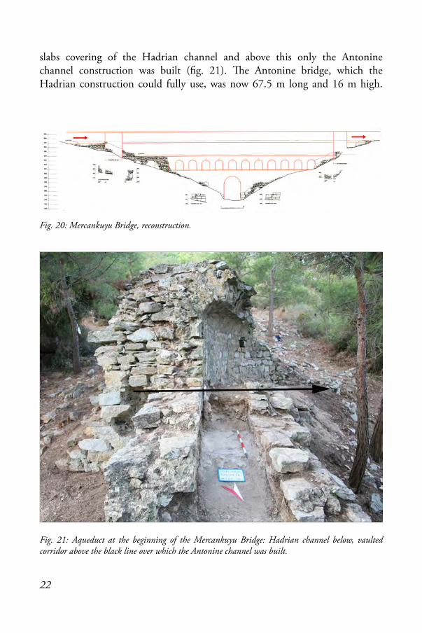
22
slabs covering of the Hadrian channel and above this only the Antonine channel construction was built (fig. 21). e Antonine bridge, which the Hadrian construction could fully use, was now 67.5 m long and 16 m high.
Fig. 21: Aqueduct at the beginning of the Mercankuyu Bridge: Hadrian channel below, vaulted corridor above the black line over which the Antonine channel was built.
Fig. 20: Mercankuyu Bridge, reconstruction.

23
Tunnels
e longest of four tunnels is the Kalafat / Ayhan tunnel, which is 730 m long. e qanat tunnel has 17 shafts, five of which are now closed. e lowest shaft in the north measures 3.70 m, and the deepest shaft at the highest point is 24.64 m. A very special feature of these tunnels are the many turns and hooks (fig. 22), which can be traced back to corrections of measurement errors during construction, whereby the tunnel had to be found by so-called ‘final insur-ance hooks’.
Subsequent repairs to the Antonine aqueduct
e new construction of the Antonine aqueduct from the İçmetepe fault to the Bahçecikboğaz Bridge had an extremely low gradient of approximatively 10 cm per one kilometre. As a result, the line in this area was very prone to failure and often had to be repaired, therefore further operation of the aqueduct could only be guaranteed at great expense. is is proven by the discovery of at least seven diversion lines in this short area.
Frontinus writes about such diversions in his book. So far only a few such diver-sions have been found in Roman aqueducts and these mainly concern bridge
Fig. 22: Inside the Kalafat / Ayhan tunnel.

24
constructions, so it is all the more astonishing that at least eight such ‘bypasses’ have now been discovered in the Değirmendere aqueduct.
As an example, only one of these bypasses is mentioned here (fig. 23): it begins 250 m after the Killikdere Bridge and is 51.5 m in full length. e uphill side wall of the original Antonine channel was used as the downhill side wall of the bypass. On the one hand, remains of opus signinum from the original channel still adhered to its outer side of the bypass, and on the other hand, the opus signinum and the sintering of the original canal are still preserved under the six supporting pillars attached to the bypass (fig. 24). e original channel’s downhill side wall is missing because the stones were probably used as building material for the construction of the uphill side wall of the bypass or for the masonry of the supporting pillars. At the beginning of the bypass one can clearly see how the diversion was led out of the original channel before it was closed with masonry. Also at the end of the bypass one can clearly see the blocking of the original Antonine channel.
Of the other bypasses in this section, only the beginning or the end could be found, while the stretches in between are still buried underground. It is also possible that among these sections a beginning and an end could also belong to a single bypass and not to different ones, but this cannot be proven without laborious and cost-intensive excavation work.
Fig. 23: Bypass 1 in section X.

25
In addition to the bypasses, supporting pillars were also attached to the substruc-ture and the wall of the aqueduct on the valley side to provide better support for the aqueduct in later times (fig. 25). ese supporting pillars are unique because they have not yet been observed at any other Roman aqueduct. e reason for the erection of the supporting pillars is the absorption of the pressure
Fig. 24: Bypass line on the right, which uses the hillside wall of the then disused Antonine channel as valleyside wall for the bypass (with supporting pillar) in the middle
and the Hadrian aqueduct on the far left (not visible).
Fig. 25: Supporting pillars in section X on the south side of the Bahçecikboğaz Valley.

26
caused by soil, boulders and water slipping down the slope. Supporting pillars occur exclusively at the Antonine aqueduct and only in zone II. A total of 259 supporting pillars could be recorded, which had a width of 90-127 cm (in one case 3.80 m), a depth of 80-397 cm and a preserved height of 68-304 cm. It is unclear, however, why the piers were completely missing on long stretches, while they were set very densely between them. Only on the northern side of the Bahçecikbogaz Valley, where the Antonine channel is situated on the slope above the Hadrian channel, two types of supporting pillars can be distinguished: with type I the supporting pillar was built into the Hadrian channel, because its cover plate was missing already or used as building material for the new aqueduct, with type II the supporting pillar was put on the still existing cover plate.
THE JUSTINIAN AQUEDUCT TO ST. JOHN’S BASILICA ON AYASOLUK HILL
In the 6th century AD, when the port of Ephesus silted up and the emergence of epidemics in the unhealthy remaining area forced the inhabitants to settle further inland on the hill north of the ruins of the temple of Artemis, the mighty St. John’s Basilica was built here over the remains of a predecessor church. Emperor Justinian himself commissioned the technites Lazaros, presumably an outstand-ing aqueduct builder, to lead the water from the source of the Roman Şirince aqueduct to this hill and allowed him to rob the pagan temple of its stones (see fig. 29). Between AD 549 and 565 Lazaros built an enormous siphon on behalf of Archbishop Johannes, the remains of which can still be admired today in the city of Selçuk. e venter had a length of 656 m and counted 124 square piers of 1.70 to 2.0 m side length with pier spacing’s of 5.20 to 6 m (fig. 26 and front cover). e construction was carried out in the direction of the water flow,
Fig. 26: Highest pillars of the Justinian Selçuk aqueduct bridge at Atatürk square. In front of the rightmost pillar is a suterasi-tower from the 14th century.

27
because from pillar number 95 onwards there is a lack of spolia from the Artemis temple, so that the other pillars were built up with alternating layers of quarry stones and bricks. On this bridge, which reached a height of more than 10 m at the deepest point of the valley, a stone pipeline was laid, whereby the pipes were made from drilled spolia using Roman column drums and capitals with worked male/female sockets. 78 pieces of these spolia out of possible a total of 1,600 could still be found today.
e header tank and the receiving tank as important parts of the siphon could not be found (fig. 27). But at the end of the bridge, where the stepwise higher arch supports at piers 114 to 117 indicate an ascending ramp, there is a large stone slab with an embedded vertical, i.e. ascending pipe at a height of approx-imatively 30 masl. is pipe must have led to the top of an approximatively 10 m high tower on which the receiving tank of the siphon must have been located. is reconstructed tower and the rest of a brick pier with an ascending and descending pipe in the corridor next to the Baptistery of the Basilica at about 40 masl suggest that a system of water towers would have been needed between these two piers to supply the church and the surrounding settlement with water.
is construction shows that on the one hand the technique of Greek and Roman siphons was still used in the Byzantine period; and on the other hand the suterasi towers were already in use in the Byzantine period, as they had been in Pompeii and elsewhere before. e suterasi towers attached to the bridge in the south were used in the 14th century to supply the area around the Isa-Bey Mosque with water from the Şirince spring.
Fig. 27: Reconstruction of the siphon to the Ayasoluk hill.

28
CONCLUSION
e water supply of Ephesus was thus secured at all times (fig. 29): the oldest pipeline was already found in the area of the Artemis temple from the 5th or 4th century BC. In Hellenistic and Roman times, smaller clay pipelines, and later the two large channel aqueducts supplied the resettled city. While in Byzantine times the Justinian Basilica of St. John with the surrounding settlement was supplied by a pressure pipeline, and the Seljuk Isa Bey-Mosque as well as several baths with the sutrerasi pipeline in the 14th century AD.
As a conclusion I would like to show a small detail: at the Değirmendere aque-duct we discovered a footprint in the opus signinum of the channel bottom (fig. 28). A careless worker probably left a tool here, which he retrieved after finishing his work. A small sign that also bears witness to the human dimension of all these enormous buildings.

29
Fig. 29 (below): In front is the area of the Artemis temple, behind from left the Byzantine-Seljuk castle, the Seljuk Isa-Bey mosque, the basilica of St. John and the entrance gate to the Byzantine settlement (Tor der Verfolgung).
Fig. 28 (right): Footprint on the bottom of the Antonine channel immediately after the Adamtoluboğaz aqueduct bridge in section XV.

30
ACKNOWLEDGEMENTS
It is a great honour for me to be invited to give the irteenth Annual Byvanck lecture and my grateful thanks go to the BABESCH Foundation for their kind invitation and generous hospitality, especially to Gert Jan van Wijngaarden and Vanessa Boschloos for their care and organisation and editorial work on this booklet. I would like to emphasize that the Değirmendere project in Ephesos was a team effort and that I am especially indebted to my main staff members: Nicole Birkle, Gemma Jansen, Paul Kessener, Ralf Kreiner, Christian Kurtze, Annette Nießner, Cees Passchier and Marco Placidi. But I would also like to take this opportunity to thank all the other employees involved in the project: Adalberto Boccitto, Alfonso Diaz Boj, Orçun Erdoğan, Franz Fichtinger, Vittoria Fresi, Doğu Gital, Sevgi Gürleyen, Stefan Klotz, Francesco Leteri, Adriano Morabito, Noor Mulder-Hymans, Riccardo Paolucci, Susanne Piras, Johann Ruhdorfer, Gül Sürmelihindi, Sürme Ucan, Eva Maria Unger and Ramazan Yazıcı. I thank Dennis Murphy for bending my poor English to the right position.

31
REFERENCES
Alzinger, W. 1987, Ephesos, in Frontinus-Gesellschaft (ed.), Die Wasserversorgung antiker Städte (Geschichte der Wasserversorgung 2), Mainz, 180-184.
Ashby, . 1935, The Aqueducts of Ancient Rome, Oxford.
Bammer, A. 1984, Das Heiligtum der Artemis von Ephesos, Graz, 131.
Benndorf, O. 1906a, Zur Ortskunde und Stadtgeschichte (FiE 1), Vienna, 9-110.
Blackman D.R. / A.Tr. Hodge (eds), 2001, Frontinus’ Legacy, Essays on Frontinus’ de aquis urbis Romae, Ann Arbor.
Burdy, J. 1987, L’Aqueduc Romain du Mont d´Or, Lyon.
Burdy, J. 1996, L’Aqueduc Romain du Gier, Lyon.
Crouch, D. / C. Ortloff 2001, e Urban Water Supply and Distribution System of the City of Ephesus in the Roman Period, JASc 28, 843-860.
Fabre, G. / J.-L. Fiches / J.-L. Paillet 2000, L´Aqueduc de Nîmes et le Pont du Gard, Paris.
Fahlbusch, H. 1982, Vergleich antiker griechischer und römischer Wasserversorgungsanlagen, MInstWasser 73.
Forchheimer, P. 1923, Wasserleitungen (FiE 3), Vienna, 224-255.
Foss, C. 1979, Ephesus after Antiquity. A Late Antique Byzantine and Turkish City, Cambridge.
Garbrecht, G. 2001, Die Wasserversorgung von Pergamon (AvP I/4), Berlin/New York.
Gébara Ch. / J.-M. Michel (eds) 2002, L’Aqueduc Romain de Fréjus (RANarb Suppl. 33), Montpellier.
Grewe, K. 1986, Atlas der römischen Wasserleitungen nach Köln (Rheinische Ausgrabungen 26), Cologne.
Grewe, K. 1985, Planung und Trassierung römischer Wasserleitungen (Schriftenreihe der Fronti-nus-Gesellschaft, Suppl. 1), Wiesbaden.
Grewe, K. 1998, Licht am Ende des Tunnels, Planung und Trassierung im Antiken Tunnelbau, Mainz.
Grewe, K. 2014, Aquädukte, Wasser für Roms Städte, Rheinbach.
Hodge, A.T. 1992, Roman Aqueducts & Water Supply, London.
Kessener, H. P. M. 2000, e Aqueduct at Aspendos and its Inverted Siphon, JRA 13, 104.
32
Kienast, H. J. 1995, Die Wasserleitung des Eupalinos auf Samos (Samos XIX), Bonn.
Letzner, W. / W. Merkel 2013, Sextus Iulius Frontinus, De Aquaeductu Urbis Romae. Die Was-serversorgung der Stadt Rom, in Frontinus-Gesellschaft (ed.), Die Wasserversorgung im antiken Rom (Geschichte der Wasserversorgung 1), Munich, 9-97.
Ortloff, C. / D. Crouch 2001, e Urban Water Supply and Distribution System of the Ionian City of Ephesos in the Roman Imperial Period, JASc 28, 843-860.
Öziş, Ü./A. Atalay 1999, Fernwasserleitungen von Ephesos, in H. Friesinger / F. Krinzinger (eds), 100 Jahre Osterreichische Forschungen in Ephesos. Akten des Symposiums, Wien 1995 (Denkschr-Wien 260), Vienna, 405-411.
Öziş, Ü. / A. Atalay / M. Becerik / K. Özdikmen 2005a, Tunnelstrecken in Qanatbauweise. Der Kenchrios - (Değirmendere) - Fernwasserleitung nach Ephesus, in Frontinus-Gesellschaft (ed.), Internationales Frontinus-Symposium „Wasserversorgung aus Qanaten - Vorbilder im Tunnelbau (Frontinus-Schriftenreihe 26), Bonn, 293-300.
Öziş, Ü./A. Atalay/M. Becerik/k. Özdikmen 2005b, Aqua Iulia. Die Kenchrios (Değrmendere) - Fernwasserleitung von Ephesus, in B. Brandt / V. Gassner / S. Ladstätter (eds), Synergia - Fest-schrift für Friedrich Krinzinger 1, Vienna, 213-219.
Passchier, C.W. / G. Wiplinger / T. Güngör / P. Kessener / G. Sürmelihindi 2013, Normal Fault Displacement Dislocating a Roman Aqueduct of Ephesus, Western Turkey, Terra Nova 25, 292-297.
Quatember, U. 2011, Das Nymphaeum Traiani in Ephesos (FiE 11.2), Vienna.
Scherrer, P. 1995, Ephesos. Der neue Führer, Vienna.
Scherrer, P. 2006, Die Fernwasserversorgung von Ephesos in der römischen Kaiserzeit. Synopse der epigraphischen Quellen, in G. Wiplinger (ed.), Cura Aquarum in Ephesus. Proceedings of the Twelfth International Congress on the History of Water Management and Hydraulic Engineering in the Mediterranean Region. Ephesus/Selçuk, Turkey, October 2-10-2004 (BABESCH Suppl. 12, SoSchrÖAI 42), Leuven, 45-60.
Taeuber, H. 2016, Ein Kaiserbrief des Antoninus Pius zu einem bisher unbekannten Erdbeben in Ephesos, ÖJh 84, 301-310.
ür H. / E. Rathmayr (eds) 2014, Hanghaus 2 in Ephesos. Die Wohneinheit 6. Baubefund, Auss-tattung, Funde (FiE 8.9), Vienna, Taf. 338, Abb. 11.
Wikander, Ö 2000, Handbook of Ancient Water Technology, Technology and Change in History 2, Leiden/Boston/Cologne.
Wilberg, W. 1923a, Der Aquädukt des C. Sextilius Pollio (FiE 3), Wien, 256-262.
Wiplinger, G. 2002, Wasserver- und -entsorgung in Wohneinheit 1 und 2 des Hanghauses 2 in Ephesos, in Ch. Ohlig / Y. Peleg / T. Tsuk (eds), Cura Aquarum in Israel, Proceedings of the 11th
33
International Conference on the History of Water Management and Hydraulic Engineering in the Mediterranean Region, Israel 2001 (Schriften der Deutschen Wasserhistorischen Gesellschaft 1), Siegburg, 155-166.
Wiplinger, G. 2006a, Wasser für Ephesos. Stand der Erforschung der Wasserversorgung, in G. Wiplinger (ed.), Cura Aquarum in Ephesus. Proceedings of the Twelfth International Congress on the History of Water Management and Hydraulic Engineering in the Mediterranean Region. Ephesus/Selçuk, Turkey, October 2-10 2004 (BABesch Suppl. 12, SoSchrÖAI 42), Leuven, 23-40.
Wiplinger, G. 2006b, Stand der Erforschung der Wasserversorgung in Ephesos/Türkei, in Fron-tinus-Gesellschaft (ed.), Frontinus-Tagungen 2004/2006 in Wien und Berlin (Schriftenreihe der Frontinus-Gesellschaft 27), Bonn, 15-48.
Wiplinger, G. 2006c, Der lysimachische Aquädukt von Ephesos und weitere Neuentdeckungen von 2005, in Frontinus-Gesellschaft (ed.), Frontinus-Tagungen 2004/2006 in Wien und Berlin (Schriftenreihe der Frontinus-Gesellschaft 27), Bonn, 121-126.
Wiplinger, G. 2008, Neue Ergebnisse zur Wasserversorgung in Ephesos, in C. Ohlig (ed.), Cura Aquarum in Jordania. Proceedings of the 13th International Congress on the History of Water Man-agement and Hydraulic Engineering in the Mediterranean Region. Petra/Amman. 31 March - 9 April 2007 (Schriften der Deutschen Wasserhistorischen Gesellschaft 12), Siegburg, 313-327.
Wiplinger, G. 2010a, Die Wasserversorgung von Ephesos in byzantinischer Zeit, in F. Daim / J. Drauschke (eds), Byzanz - das Römerreich im Mittelalter 2.2 (Monographien des Römisch-Ger-manischen Zentralmuseums, 84.2.2), Mainz, 593-613.
Wiplinger, G. 2010b, Wasserwirtschaftliche Einrichtungen, in F. Krinzinger (ed.), Hanghaus 2 in Ephesos. Die Wohneinheiten 1und 2 (FiE 8.8), Vienna, 156-159, 525-526.
Wiplinger, G. 2010c, The Değirmendere Aqueduct to Ephesus (Anodos 8/2008), Trnava, 393-400.
Wiplinger, G. 2013a, Der Değirmendere Aquädukt von Ephesos und seine Zukunft, in G. Wiplinger (ed.), Historische Wasserleitungen. Gestern-Heute-Morgen, Tagungsband des Internatio-nalen Frontinus-Symposiums, Wien, 19.-23. Oktober 2011 (BABesch Suppl. 24, SoSchrÖAI 49), Leuven, 105-129.
Wiplinger, G. 2013b, Der Değirmendere-Aquädukt, in Österreichisches Archäologisches Insti-tut (ed.), Wissenschaftlicher Jahresbericht des Österreichischen Archäologischen Instituts, 19-21.
Wiplinger, G. 2019, Der Değirmendere Aquädukt von Ephesos (BABESCH suppl. 36), Leuven.

34
LIST OF FIGURES
Cover illustration: Remains of the Byzantine aqueduct to the St. John’s Basilca at Ephesus (photo author, © ÖAW-ÖAI).
Fig. 1: Terrace House 2, living unit 1 and 2 (map author, © ÖAW-ÖAI = Österreichische Akad-emie der Wissenschaften - Österreichisches Arcäologisches Institut).
Fig. 2: Marble niche as fountain in the triclinium SR 24 of living unit 2 at Terrace House 2 with view through the door into the peristyle (photo author, © ÖAW-ÖAI).
Fig. 3: Lead pipes with stone cuffs in the Artemis temple (photo © ÖAW-ÖAI).
Fig. 4: e aqueducts of Ephesus (map C. Kurtze, author, © ÖAW-ÖAI).
Fig. 5: Büllükdere Bridge of Aqua roessitica (photo author, © ÖAW-ÖAI).
Fig. 6: Detail from the Pollio aqueduct bridge with inscription (photo author, © ÖAW-ÖAI).
Fig. 7: Remains of the Kelebek Bridge of Aqua Iulia (photo author, © ÖAW-ÖAI).
Fig. 8: Nymphaeum Traiani, a two-storey splendid fountain donated by Claudius Aristion with tabernacle architecture as the end point of the aqueduct (drawing by H. Pellionis, 1963, © ÖAW-ÖAI).
Fig. 9: Cross section of the Aristion aqueduct (drawing author, © ÖAW-ÖAI).
Fig. 10: Floor water basin and niche-fountain in the marble hall 31 of living unit 6 of Terrace House 2 (photo from ür / Rathmayr 2014, Taf. 338, Abb. 11, © ÖAW).
Fig. 11: e Değirmendere aqueduct (map C. Kurtze, author, © ÖAW-ÖAI).
Fig. 12: Hadrian aqueduct with stone slab covering and above a supporting pillar of the Antonine aqueduct in section XV (photo author, © ÖAW-ÖAI).
Fig. 13: Height diagrams of the Değirmendere aqueduct with Hadrian and Antonine aqueduct and the caesura with the tectonic fault (drawing C. Kurtze, author, © ÖAW-ÖAI).
Fig. 14: Difference between Hadrian aqueduct and Antonine aqueduct at a highly preserved area in section XVI (photo author, © ÖAW-ÖAI).
Fig. 15: Masonry type AA of the Antonine aqueduct in section XV (photo author, © ÖAW-ÖAI).
Fig. 16: Adamtoluboğaz Bridge (photo N. Gail, © ÖAW-ÖAI).
Fig. 17: Bahçecikboğaz-siphon-bridge to the left the Hadrian and Antonine channel in section XIV (photo author, © ÖAW-ÖAI).

35
Fig. 18: Bahçecikboğaz siphon-bridge, reconstruction (drawing F. Fichtinger, C. Kurtze, author, © ÖAW-ÖAI).
Fig. 19: Bahçecikboğaz siphon-bridge with Hadrian header tank with the waste of the unneeded terracotta pipes at the place of the double basin of the Antonine header tank, the venter in the middle and the ascending ramp at the opposite valley side (photo author, © ÖAW-ÖAI).
Fig. 20: Mercankuyu Bridge, reconstruction (drawing F. Fichtinger, C. Kurtze, author, © ÖAW-ÖAI).
Fig. 21: Aqueduct at the beginning of the Mercankuyu Bridge: Hadrian channel below, vaulted corridor above the black line over which the Antonine channel was built (photo author, © ÖAW-ÖAI).
Fig. 22: Inside the Kalafat / Ayhan tunnel (photo CRSA-Sotterranei di Roma, © ÖAW-ÖAI).
Fig. 23: Bypass 1 in section X (aerial photo © ÖAW-ÖAI).
Fig. 24: Bypass line on the right, which uses the hillside wall of the then disused Antonine channel as valleyside wall for the bypass (with supporting pillar) in the middle and the Hadrian aqueduct on the far left (not visible) (photo author, © ÖAW-ÖAI).
Fig. 25: Supporting pillars in section X on the south side of the Bahçecikboğaz Valley (photo author, © ÖAW-ÖAI).
Fig. 26: Highest pillars of the Justinian Selçuk aqueduct bridge at Atatürk square. In front of the rightmost pillar is a suterasi-tower from the 14th century (photo author, © ÖAW-ÖAI).
Fig. 27: Reconstruction of the siphon to the Ayasoluk hill (drawing P. Kessener).
Fig. 28: In front is the area of the Artemis temple, behind from left the Byzantine-Seljuk castle, the Seljuk Isa-Bey mosque, the basilica of St. John and the entrance gate to the Byzantine settle-ment (Tor der Verfolgung) (photo author, © ÖAW-ÖAI).
Fig. 29: Footprint on the bottom of the Antonine channel immediate after the Adamtoluboğaz aqueduct bridge in section XV (photo author, © ÖAW-ÖAI).


Gilbert Wiplinger was architect and building researcher at the Austrian Archaeological Institute (ÖAI) in Vienna from 1978 to 2018. He finished his studies of architecture at the Technical University of Vienna in 1978 with the thesis Securing the ruins of the Terrace Houses at Ephesus as a student of Hermann Vetters, past director of the ÖAI and Ephesus excavations. He designed and
developed roofs over the living units 1 and 2 in the Terrace House 2 of Ephesus, oversaw their restoration (1978-1988) and also planned and managed the reconstruction and expansion of the excavation settlements in Ephesus and Tell el-Dabca (Egypt), where he also participated in the excavations (1990-2005). As a building researcher, he investigated the above-mentioned living units (1995-2000), where his interest in water supply in antiquity and the Frontinus Society was awakened. Since 2001, he has been researching the aqueducts of Ephesus in general, and the Değirmendere aqueduct in detail working with an international and interdisciplinary team. e results of this research are published in BABESCH Supplement 36 (2019).
Wiplinger has organized multiple conferences on the history of water management and hydraulic engineering in the Mediterranean Region, the proceedings of which appeared in the BABESCH Supplement series: Ephesus 2004 Cura aquarum in Ephesus (vol. 12), Vienna 2011 Historische Wasserleitungen. Gestern - Heute - Morgen (vol. 24), Antalya 2014 De auqaeductu atque aqua urbium Lyciae Pamphyliae Pisidiae - The Legacy of Sextus Julius Frontinus (vol. 27), Trier 2016 (as co-organiser) Wasserwesen zur Zeit des Frontinus. Bauwerke - Technik - Kultur (with W. Letzner, vol. 32), and Rome 2018 De aqueductu urbis Romae - Sextus Julius Frontinus and the water of Rome (forthcoming). Gilbert Wiplinger is member of the board of the Frontinus Society since 2006 and chairman of the Scientific Advisory Board since 2015. In 2016, he was honoured with the Frontinus Medal in recognition of his scientific achievements in the research of water supply systems, especially aqueducts in the area of ancient Ephesus.