T U R AL SCE INCE D F N O A U D N E D I L P ANSF OITA ...
5
2008 A P P L I E D A N D N A T U R A L S C I E N C E F O U N D A T I O N ANSF JANS Journal of Applied and Natural Science 8 (2): 874 - 878 (2016) Signature capture of red soil patches and their acidity-A case study of Banka district, Bihar, India Binod K. Vimal, Rajkishore Kumar * , C. D. Choudhary, Sunil Kumar, Rakesh Kumar, Y. K. Singh and Ragini kumari Department of Soil Science and Agricultural Chemistry, Bihar Agricultural College, Sabour-813210, Bhagalpur, Bihar, INDIA * Corresponding author. E-mail: [email protected] Received: August 22, 2015; Revised received: March 1, 2016; Accepted: May 27, 2016 Abstract: Colour in soils as well as other object is the visual perceptual property which is perceived by human eye. They are governed by spectrum of light corresponding to wavelength or reflected energy of the material. Developed model for soil acidity is based on visual interpretation, principal component and spectral enhancement techniques by using of the satellite image (IRS LISS III, 2014). In this context, red soil patch is much sensitive in red spectral band comparison to green and blue spectral bands and perceived as red tone by human eyes but same soil patch appears green in false colour composite (FCC) image of NIR (0.70-0.80μm), Red (0.60-0.70 μm) and Green (0.50-0.60μm) bands. The maximum coverage of red soil patches having low pH < 6.5 (1:2.5) was recognized in 44.07 per cent of the total geo- graphical area (3019.56 sq.km) under Banka district. Maximum red soil patches having their acidity were recognised in Katoria (18.56%), Chanan (15.15%), Bounsi (10.44%) and Banka (9.92%) blocks. Overall results indicated that variation of tone in different bands helps for the separation of red soil patches. Keywords: NIR band, RS-GIS, Satellite image, Spectral signature ISSN : 0974-9411 (Print), 2231-5209 (Online) All Rights Reserved © Applied and Natural Science Foundation www.jans.ansfoundation.org INTRODUCTION The soils are valuable natural resources which are di- rectly or indirectly associated with agricultural activi- ties. Acidity or alkalinity in soils, affect towards nutri- ent supply in the plant. If a soil is too sour or too sweet, plants cannot take up nutrients like nitrogen (N), phosphorus (P) and potassium (K) (Buckman et. al., 2002). There are four factors that influence signa- ture of soil viz. mineral composition, organic matter, soil moisture and texture (Ben-Dor 2002). Generally, red soils appear near hilly terrain with the presence of iron oxide and they have peculiar tone from surround- ing. Wide range of soil colour; gray, black, white, red, brown and yellow is influenced by the content of or- ganic matter, presence of water and oxidation state of iron and magnesium. Iron oxides, clay minerals and soil colour can be measured directly from the spectra (Viscarra Rossel et al., 2009). When light hits objects i.e. soil, water, vegetation some of the wavelengths are absorbed and some are reflected, depending on the materials characteristics (Panda, 2009). In this context, reflected energy from different materials in the terms of different spectral wavelengths is received by satel- lite sensors and converted into pictorial view. In con- tinuation of sensor based technology, remote sensing and Geographic Information System (GIS) techniques are widely accepted as most reliable, rapid and cost effective for collection of data on status of natural re- sources over large areas (Saxena et al., 2000). Remote sensing data have been used for soil classification, soil resources mapping (Ray et al. 2002, 2004), soil mois- ture assessment (Engman and Chuhan 1995) and soil degradation (salinity) and mapping (Metternicht et . al. 2003). Examples of some factors that most commonly affect the soils and soil properties (s) as described by V.V. Dokuchaev in Russia and others such as by H. Jenny in the U.S. are climate (cl), organisms (o), to- pography (r), parent material (p) and time (t) (Jenny 1941). Integrating these factors to express the dynamic nature of soil formation has been shown in the follow- ing equation provided by Hans Jenny. S= f (cl, b, r, p, t).This equation puts forth the idea that for any specific soil property within a soil such as pH and clay content etc.(Bricklemyer et. al. 2010) that property is a func- tion of soil forming factors, each being independent but working in unison to form unique soils in Banka district.Soil survey towards land use planning is an important part for the sustainability of agriculture prac- tices. Soil resource inventory provides adequate infor- mation in terms of land form, natural vegetation as well as characteristics of soils which can be utilized for land resources management and development (Manchanda et. al., 2002). However, yellow or red soil indicates the presence of iron oxides and their colour associations are influenced by reflected or absorbed energy. Results showed a good correlation between the spectral reflectance from field measurements and
Transcript of T U R AL SCE INCE D F N O A U D N E D I L P ANSF OITA ...

2008
APP
LIE
D
AN
DN
ATURAL SCIENCEFO
UN
DA
TIO
NANSFJANS Journal of Applied and Natural Science 8 (2): 874 - 878 (2016)
Signature capture of red soil patches and their acidity-A case study of Banka
district, Bihar, India
Binod K. Vimal, Rajkishore Kumar*, C. D. Choudhary, Sunil Kumar, Rakesh Kumar,
Y. K. Singh and Ragini kumari
Department of Soil Science and Agricultural Chemistry, Bihar Agricultural College, Sabour-813210, Bhagalpur,
Bihar, INDIA *Corresponding author. E-mail: [email protected]
Received: August 22, 2015; Revised received: March 1, 2016; Accepted: May 27, 2016
Abstract: Colour in soils as well as other object is the visual perceptual property which is perceived by human eye. They are governed by spectrum of light corresponding to wavelength or reflected energy of the material. Developed model for soil acidity is based on visual interpretation, principal component and spectral enhancement techniques by using of the satellite image (IRS LISS III, 2014). In this context, red soil patch is much sensitive in red spectral band comparison to green and blue spectral bands and perceived as red tone by human eyes but same soil patch appears green in false colour composite (FCC) image of NIR (0.70-0.80μm), Red (0.60-0.70 μm) and Green (0.50-0.60μm) bands. The maximum coverage of red soil patches having low pH < 6.5 (1:2.5) was recognized in 44.07 per cent of the total geo-graphical area (3019.56 sq.km) under Banka district. Maximum red soil patches having their acidity were recognised in Katoria (18.56%), Chanan (15.15%), Bounsi (10.44%) and Banka (9.92%) blocks. Overall results indicated that variation of tone in different bands helps for the separation of red soil patches.
Keywords: NIR band, RS-GIS, Satellite image, Spectral signature
ISSN : 0974-9411 (Print), 2231-5209 (Online) All Rights Reserved © Applied and Natural Science Foundation www.jans.ansfoundation.org
INTRODUCTION
The soils are valuable natural resources which are di-
rectly or indirectly associated with agricultural activi-
ties. Acidity or alkalinity in soils, affect towards nutri-
ent supply in the plant. If a soil is too sour or too
sweet, plants cannot take up nutrients like nitrogen
(N), phosphorus (P) and potassium (K) (Buckman et.
al., 2002). There are four factors that influence signa-
ture of soil viz. mineral composition, organic matter,
soil moisture and texture (Ben-Dor 2002). Generally,
red soils appear near hilly terrain with the presence of
iron oxide and they have peculiar tone from surround-
ing. Wide range of soil colour; gray, black, white, red,
brown and yellow is influenced by the content of or-
ganic matter, presence of water and oxidation state of
iron and magnesium. Iron oxides, clay minerals and
soil colour can be measured directly from the spectra
(Viscarra Rossel et al., 2009). When light hits objects
i.e. soil, water, vegetation some of the wavelengths are
absorbed and some are reflected, depending on the
materials characteristics (Panda, 2009). In this context,
reflected energy from different materials in the terms
of different spectral wavelengths is received by satel-
lite sensors and converted into pictorial view. In con-
tinuation of sensor based technology, remote sensing
and Geographic Information System (GIS) techniques
are widely accepted as most reliable, rapid and cost
effective for collection of data on status of natural re-
sources over large areas (Saxena et al., 2000). Remote
sensing data have been used for soil classification, soil
resources mapping (Ray et al. 2002, 2004), soil mois-
ture assessment (Engman and Chuhan 1995) and soil
degradation (salinity) and mapping (Metternicht et. al.
2003). Examples of some factors that most commonly
affect the soils and soil properties (s) as described by
V.V. Dokuchaev in Russia and others such as by H.
Jenny in the U.S. are climate (cl), organisms (o), to-
pography (r), parent material (p) and time (t) (Jenny
1941). Integrating these factors to express the dynamic
nature of soil formation has been shown in the follow-
ing equation provided by Hans Jenny. S= f (cl, b, r, p,
t).This equation puts forth the idea that for any specific
soil property within a soil such as pH and clay content
etc.(Bricklemyer et. al. 2010) that property is a func-
tion of soil forming factors, each being independent
but working in unison to form unique soils in Banka
district.Soil survey towards land use planning is an
important part for the sustainability of agriculture prac-
tices. Soil resource inventory provides adequate infor-
mation in terms of land form, natural vegetation as
well as characteristics of soils which can be utilized for
land resources management and development
(Manchanda et. al., 2002). However, yellow or red soil
indicates the presence of iron oxides and their colour
associations are influenced by reflected or absorbed
energy. Results showed a good correlation between
the spectral reflectance from field measurements and

875 Binod K. Vimal et al. / J. Appl. & Nat. Sci. 8 (2): 874 - 878 (2016)
the spectral reflectance obtained from analyzing the
satellite imagery (Hussien et. al. 2014). Therefore,
spectral variation over red soils provides an opportu-
nity for the separation from surroundings. Signature
capture of perfect tone or spectral responses of the
target from satellite image is a researchable issue in RS
-GIS domain. Keeping in view and to short out the
problem, the present study was carried out for the
spectral signature capture of red soil patches corre-
sponding to soil pH under Banka district of Bihar.
MATERIALS AND METHODS
Study area: Banka district of Bihar, India was se-
lected for the signature capture of red soil patches
(Fig.1). It is situated in far south east of the State Bihar
having geographical extension of 24030’ to 2506’N and
86030’E to 87007’E.The eastern and southern border of
the district coincides with district Godda of the state Jhark-
hand. In west and north east it touches Jamui and Munger
district, respectively. The old district Bhagalpur is situated in
the north side of Banka. The geographical area of the dis-
trict is 3019.3465 km2 having eleven blocks. Field survey
was done during the month of February, 2014 and eight
locations under red soil patches were selected with GPS
reading for visual interpretation and image enhancement of
the satellite image. Soil pH was analyzed as per the standard
procedure by Jackson (1973) in the laboratory for the avail-
ability of acidity level in red soils.
Principal component analysis (PCA): The principal com-
ponents process the spectral bands to derive a reduced num-
ber of parameters (dimensional reduction) and increase
interpretability. Generally, processed maps are derived
from a statistical analysis of the input rasters which is
processes under principal component. In principal
component (PC) analysis, one can use the standard or
selective analysis, the difference being that in the for-
mer, while in the later, only certain bands are chosen
(Crosta and Moore, 1989).The principal components
that contain spectral information about specific materi-
als, as well as the contribution of individual original
bands in relation to the spectral response of the materi-
als of interest. Spectral Feature Fitting to create a simi-
larity score to compare to all other soil samples within
the spectral library (Spatial Analyst, http://geol.hu/
data/online 2012). Principal Component Analysis
(PCA) under spectral enhancement was done for the
separation of red soil patches from surroundings. To
achieve this target, IRS LISS III satellite image (spatial
resolution 23.5m x 23.5m) during the month of March,
2014 and TNT mips (licensed version spatial related
software) were used. Ground truth towards red soil
patches under PCA analyzed image in different loca-
tions was done using GPS and toposheets. Statistical
analysis was performed to optimize the number of
spectral bands and spectral parameter to be used for
estimating soil nutrient content for the unknown
pixels of the image (Ghosh et. al., 2012). Details of
methodology towards visual interpretation and spec-
tral enhancement processes are being summarised in
given flow chart.
RESULTS AND DISCUSSION
Healthy vegetation appears green due to high reflec-
tance of green band comparison to blue and red bands
IRS LISS III (March, 2014) Toposheet (1:250000)
Geo-referencing
Subset/Area of Interest (AOI)
Visual interpretation Identification of red soil patch in different locations
Identification of red soil patches on FCC image Soil samples for soil pH
PCA of SWIR, NIR & red bands under spectral enhancement Tested in laboratory
Separation of red soil patches from PCA classified image Ground truth
Prepared a digital map for red soil patches
Fig. 1. Location map of the study area. (Data Source-IRS LISS III, 2014)

876 Binod K. Vimal et al. / J. Appl. & Nat. Sci. 8 (2): 874 - 878 (2016)
Fig. 2. False Colour Composite image.
Fig. 3. Red soil patch in green tone.
Fig. 4. Spectral response of red soil.
Fig. 5. PCA image of red soil patch.
S.N. Latitude Longitude Soil pH (1:2.5)
1 24057’42’’N 86053’25’’E 5.72
2 24055’00’’N 86053’45’’E 5.91
3 24047’33’’N 86052’46’’E 5.66
4 24042’48’’N 86050’00’’E 5.83
5 24031’50’’N 86026’28’’E 5.73
6 24039’27’’N 86052’10’’E 5.71
7 24044’59’’N 8702’33’’E 5.85
8 24038’57’’N 87000’41’’E 5.55
Table 1. GPS based locations surveyed for spectral signa-
ture towards validation of red soil patches and soil pH
(1:2.5), (Locations are plotted in serial number on FCC
image, Fig. 2).
S.N. Latitude Longitude Soil pH (1:2.5) 1 24057’58’’N 86053’12’’E 5.81 2 24052’46’’N 86051’54’’E 5.76 3 24048’20’’N 86048’32’’E 5.64 4 24046’00’’N 86049’14’’E 5.83 5 24042’26’’N 86049’14’’E 5.81 6 24042’26’’N 86038’12’’E 5.84 7 24040’48’’N 86048’39’’E 5.71 8 24036’09’’N 86043’43’’E 5.82 9 24036’42’’N 86048’45’’E 5.92 10 24037’53’’N 87002’21’’E 5.75
Table 2. GPS based locations surveyed for spectral signa-
ture towards validation of red soil patches and soil pH
(1:2.5), (Locations are plotted in serial number on PCA
image, Fig.5).
Different CD blocks under Banka district
of Bihar
Geog. Area
(km2)
Area under red soil patches
(km2)
Percentage of red soil
patches
Sambhuganj 179.75 3.60 5.95
Amarpur 186.25 7.45 6.17
Rajoun 197.51 5.93 6.54
Dhoraiya 234.14 14.05 7.75
Barahat 147.28 4.42 4.88
Banka 299.64 239.71 9.92
Phullidumar 205.04 123.02 6.79
Belhar 236.58 123.02 7.83
Chanan 457.47 416.30 15.15
Katoriya 560.57 521.33 18.56
Baunsi 315.33 214.42 10.44
Total 3019.56 1673.25 100
Table 3. Total Geographical area, covered with red soil patches in different blocks of Banka district.
877
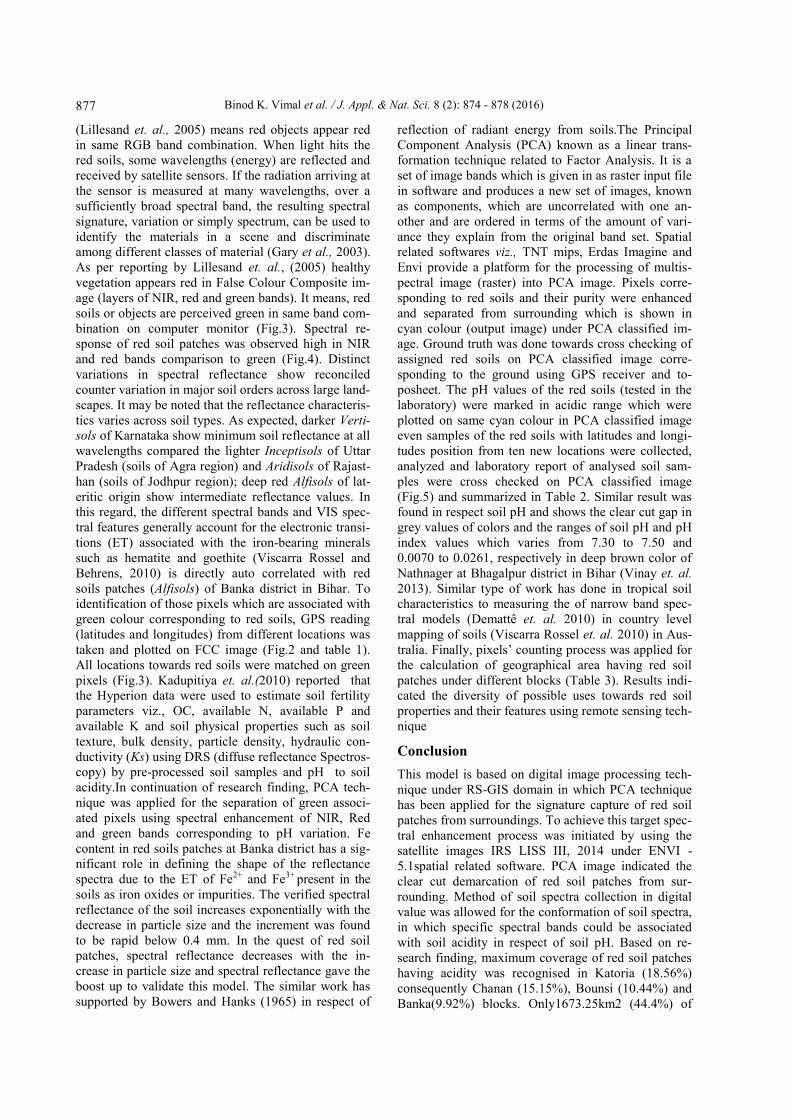
(Lillesand et. al., 2005) means red objects appear red
in same RGB band combination. When light hits the
red soils, some wavelengths (energy) are reflected and
received by satellite sensors. If the radiation arriving at
the sensor is measured at many wavelengths, over a
sufficiently broad spectral band, the resulting spectral
signature, variation or simply spectrum, can be used to
identify the materials in a scene and discriminate
among different classes of material (Gary et al., 2003).
As per reporting by Lillesand et. al., (2005) healthy
vegetation appears red in False Colour Composite im-
age (layers of NIR, red and green bands). It means, red
soils or objects are perceived green in same band com-
bination on computer monitor (Fig.3). Spectral re-
sponse of red soil patches was observed high in NIR
and red bands comparison to green (Fig.4). Distinct
variations in spectral reflectance show reconciled
counter variation in major soil orders across large land-
scapes. It may be noted that the reflectance characteris-
tics varies across soil types. As expected, darker Verti-
sols of Karnataka show minimum soil reflectance at all
wavelengths compared the lighter Inceptisols of Uttar
Pradesh (soils of Agra region) and Aridisols of Rajast-
han (soils of Jodhpur region); deep red Alfisols of lat-
eritic origin show intermediate reflectance values. In
this regard, the different spectral bands and VIS spec-
tral features generally account for the electronic transi-
tions (ET) associated with the iron-bearing minerals
such as hematite and goethite (Viscarra Rossel and
Behrens, 2010) is directly auto correlated with red
soils patches (Alfisols) of Banka district in Bihar. To
identification of those pixels which are associated with
green colour corresponding to red soils, GPS reading
(latitudes and longitudes) from different locations was
taken and plotted on FCC image (Fig.2 and table 1).
All locations towards red soils were matched on green
pixels (Fig.3). Kadupitiya et. al.(2010) reported that
the Hyperion data were used to estimate soil fertility
parameters viz., OC, available N, available P and
available K and soil physical properties such as soil
texture, bulk density, particle density, hydraulic con-
ductivity (Ks) using DRS (diffuse reflectance Spectros-
copy) by pre-processed soil samples and pH to soil
acidity.In continuation of research finding, PCA tech-
nique was applied for the separation of green associ-
ated pixels using spectral enhancement of NIR, Red
and green bands corresponding to pH variation. Fe
content in red soils patches at Banka district has a sig-
nificant role in defining the shape of the reflectance
spectra due to the ET of Fe2+ and Fe3+ present in the
soils as iron oxides or impurities. The verified spectral
reflectance of the soil increases exponentially with the
decrease in particle size and the increment was found
to be rapid below 0.4 mm. In the quest of red soil
patches, spectral reflectance decreases with the in-
crease in particle size and spectral reflectance gave the
boost up to validate this model. The similar work has
supported by Bowers and Hanks (1965) in respect of
reflection of radiant energy from soils.The Principal
Component Analysis (PCA) known as a linear trans-
formation technique related to Factor Analysis. It is a
set of image bands which is given in as raster input file
in software and produces a new set of images, known
as components, which are uncorrelated with one an-
other and are ordered in terms of the amount of vari-
ance they explain from the original band set. Spatial
related softwares viz., TNT mips, Erdas Imagine and
Envi provide a platform for the processing of multis-
pectral image (raster) into PCA image. Pixels corre-
sponding to red soils and their purity were enhanced
and separated from surrounding which is shown in
cyan colour (output image) under PCA classified im-
age. Ground truth was done towards cross checking of
assigned red soils on PCA classified image corre-
sponding to the ground using GPS receiver and to-
posheet. The pH values of the red soils (tested in the
laboratory) were marked in acidic range which were
plotted on same cyan colour in PCA classified image
even samples of the red soils with latitudes and longi-
tudes position from ten new locations were collected,
analyzed and laboratory report of analysed soil sam-
ples were cross checked on PCA classified image
(Fig.5) and summarized in Table 2. Similar result was
found in respect soil pH and shows the clear cut gap in
grey values of colors and the ranges of soil pH and pH
index values which varies from 7.30 to 7.50 and
0.0070 to 0.0261, respectively in deep brown color of
Nathnager at Bhagalpur district in Bihar (Vinay et. al.
2013). Similar type of work has done in tropical soil
characteristics to measuring the of narrow band spec-
tral models (Demattê et. al. 2010) in country level
mapping of soils (Viscarra Rossel et. al. 2010) in Aus-
tralia. Finally, pixels’ counting process was applied for
the calculation of geographical area having red soil
patches under different blocks (Table 3). Results indi-
cated the diversity of possible uses towards red soil
properties and their features using remote sensing tech-
nique
Conclusion
This model is based on digital image processing tech-
nique under RS-GIS domain in which PCA technique
has been applied for the signature capture of red soil
patches from surroundings. To achieve this target spec-
tral enhancement process was initiated by using the
satellite images IRS LISS III, 2014 under ENVI -
5.1spatial related software. PCA image indicated the
clear cut demarcation of red soil patches from sur-
rounding. Method of soil spectra collection in digital
value was allowed for the conformation of soil spectra,
in which specific spectral bands could be associated
with soil acidity in respect of soil pH. Based on re-
search finding, maximum coverage of red soil patches
having acidity was recognised in Katoria (18.56%)
consequently Chanan (15.15%), Bounsi (10.44%) and
Banka(9.92%) blocks. Only1673.25km2 (44.4%) of
Binod K. Vimal et al. / J. Appl. & Nat. Sci. 8 (2): 874 - 878 (2016)
878 Binod K. Vimal et al. / J. Appl. & Nat. Sci. 8 (2): 874 - 878 (2016)
the total geographical area (3019.56 km2) was traced
out under red soil patches which are acidic in nature.
Low coverage of red soil patches was traced out in
Sambhuganj (5.95%), Amarpur (6.17%) and Rajaun
(6.54%) block. Research findings may be helpful for
red soil inventory and mapping.
ACKNOWLEDGEMENTS
First author is thankful to Department of Science and
Technology, New Delhi for financial assistance under
ongoing research project (SB/EMEQ-173/2013). The
Chairman, Department of Soil Science & Agricultural
Chemistry, BAC, Sabour is acknowledged for his valu-
able suggestions and providing laboratory facilities.
REFERENCES
Ben-Dor, E. (2002). Quantitative remote sensing of soil
properties. Adv. Agron., 2002, 75, 173–243.
Bowers, S. and Hanks, R., (1965). Reflection of radiant
energy from soils. Soil Sci., 100, 130–138.
Bricklemyer, R.S.; Brown, D.J. On-the-go visnir (2010).
Potential and limitations for mapping soil clay and or-
ganic carbon. Comput. Electron. Agric., 70, 209-216.
Buckman, H.O. and Brady, N.C. Weil, R.R. (2002). The nature
and properties of soils, 13th Edition. Prentice Hall.
Crosta, A. P., and Moore, J. McM., (1989). Enhancement of
Landsat Thematic Mapper imagery for residual soil
mapping in SW Minas Gerais State, Brazil: a prospect-
ing case history in Greenstone Belt terrain. Proceedings
of the Seventh Thematic Conference on Remote Sensing
for Exploration Geology, Calgary, Alberta, Canada, 2- 6
October, 1173-1187.
Demattê, J.A.M., Fiorio, P.R., Araújo, S.R. (2010). Variation
of routine soil analysis when compared with hyperspec-
tral narrow band sensing method. Remote Sens., 2010,
2, 1998–2016.
Engman, E.T. and Chauhan, N. (1995). Status of microwave
soil moisture measurements with remote sensing. Re-
mote Sensing Environ., 51 (1): 189–198.
Gary A. Shaw and Hsiao-hua K. Burke, (2003). Spectral
Imaging for Remote Sensing, Lincon Laboratory Jour-
nal Volume 14, Number1.
Ghosh, R., Padmanabhan, N., Patel, K.C. and Siyolkar, R.,
Soil fertility parameter retrieval and mapping using
hyperion data (2012). In Investigations on Hyperspec-
tral Remote Sensing Applications (eds Panigrahy, S. and
Manjunath, K.R.), Space Applications Centre (ISRO),
Ahmedabad, pp. 29–31.
Hussien, H.M., Karkush, M.O. and Zibbon, A.R.T. (2014).
Studying the effects of contamination on soil properties
using remote sensing. Journal of Engineering, 6(20), 78
-90
Jackson, M.L. (1973). Soil Chemical Analysis. Prentice- hall
of India Pvt. Ltd, New Delhi, pp.40.
Jenny, H. (1941). Factors of Soil Formation a System of
Quantitative Pedology; McGraw-Hill Book Company,
Inc.: New York, NY, USA.
Kadupitiya, H.K., Sahoo, R.N., Ray, S.S., Chakraborty, D.
and Ahmed, N. (2010). Quantitative assessment of soil
chemical properties using visible (VIS) and near-
infrared (NIR) proximal hyperspectral data. Trop. Ag-
ric., 158: 41–60.
Lillesand, Thomas M., Ralph W. Kiefer, and Jonathan W.
Chipman (2005). Remote Sensing and Image Interpreta-
tion, Fifth edition. Wiley, New York.
Manchanda, M.L. Kudrat, Mand Tiwari, A.K. (2002). Soil
survey and mapping using remote sensing. Tropical
Ecology, 43: 61-74.
Metternicht, G.I. and Zinck, J.A. (2003). Remote sensing of
soil salinity: potentials and constraints. Remote Sensing
Environ., 85 (1): 1–20.
Panda, B.C. (2009). Remote sensing: Principle and applica-
tion. Viva Books Pvt Ltd.
Ray, S.S., Singh, J.P., Das, G. and Panigrahy, S. (2004). Use of
high resolution remote sensing data for generating site-
specific soil management plan. Int. Arch. Photogramm.
Remote Sensing Spatial Inf. Syst. B., 35 (7): 127–131.
Ray, S.S., Singh, J.P., Dutta, S. and Panigrahy, S. (2002).
Analysis of within field variability of crop and soil us-
ing field data and spectral information as a pre-cursor to
precision crop management. Int. Arch. Photogramm.
Remote Sensing Spatial Inf. Syst. C, 34 (7): 302–307.
Saxena, R.K., Verma , K.S., Chary, G.R., Srivastava, R. and
Bartwal, A.K. (2000). IRS-IC data application in water-
shed characterization and management. International
Journal of Remote Sensing, 21, 3197-3208.
Spatial Analyst (2012). Exelis Visual Information Solutions:
Boulder, CO, USA, Available online: http://geol.hu/
data/online_help/SpectralAnalyst.html.
Vinay, K., Vimal, B.K., K., Rakesh, K., Rakesh and K.,
Mukesh, (2013). Determination of soil pH by using
digital image processing technique. Journal of Applied
and Natural Science, 6 (1): 14-18
Viscarra Rossel RA, Cattle S., Ortega A., Fouad Y. (2009).
In situ measurements of soil colour, mineral composi-
tion and clay content by vis–NIR spectroscopy. Ge-
oderma 150, 253–266.
Viscarra Rossel, R.A. and Behrens, T. (2010). Using data
mining to model and interpret soil diffuse reflectance
spectra. Geoderma, 158, 46–54.