RH Banda Nature
2
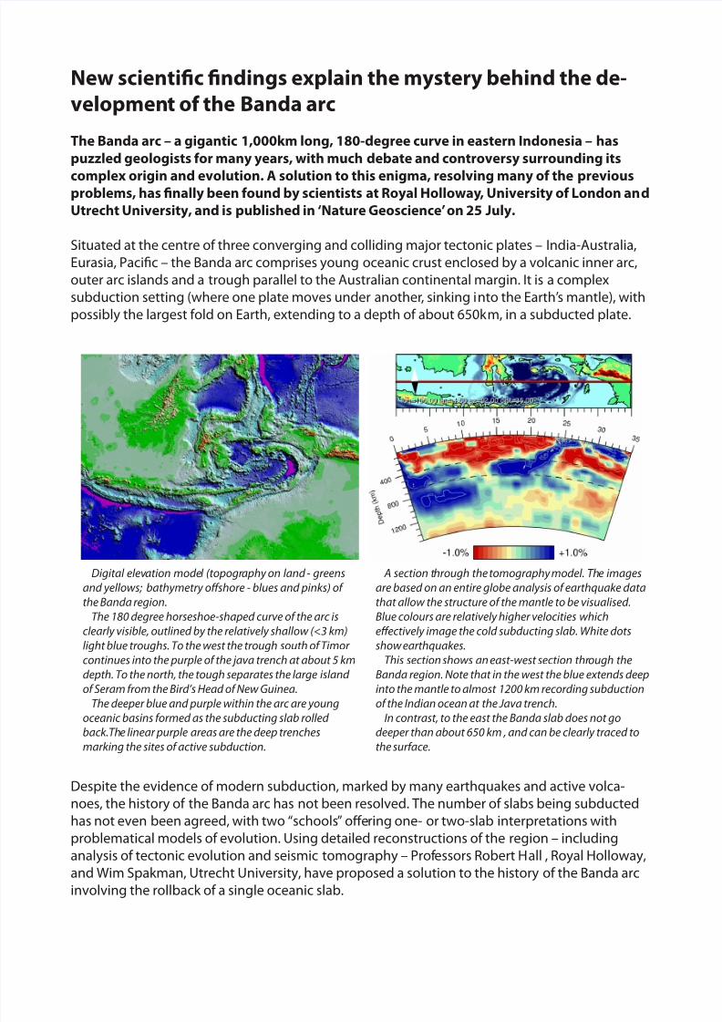
New scientific findings explain the mystery behind the de- velopmen t of the Banda arc The Banda arc – a gigantic 1,000km long, 180-degree curve in eastern Indonesia – has puzzled geologists for many years, with much debate and controversy surrounding its complex origin and evolution. A solution to this enigma, resolving many of the previous problems, has finally been found by scientists at Royal Holloway , University of London an d Utrecht University, and is published in ‘Nature Geoscience’ on 25 July. Situated at the centre of three converging and colliding major tectonic plates – India-Australia, Eurasia, Pacific – the Banda arc comprises young oceanic crust enclosed by a volcanic inner arc, outer arc islands and a trough parallel to the Australian continental margin. It is a complex subduction setting (where one plate moves under another , sinking i nto the Earth’ s mantle), with possibly the largest fold on Earth, extending to a depth of about 650k m, in a subducted plate. Despite the evidence of modern subduction, marked by many earthquakes and active volca- noes, the history of the Banda arc has not been resolved. The number of slabs being subducted has not even been agreed, with two “schools” offering one- or two-slab interpretations with problematical models of evolution. Using detailed reconstructions of the region – including analysis of tectonic evolution and seismic tomography – Prof essors Robert H all , Royal Holloway, and Wim Spakman, Utrecht University, have proposed a solution to the history of the Banda arc involving the rollback of a single oceanic slab. Digital elev ation mode l (topogr aphy on land - greens and yellows; bathymetry offshore - blues and pinks) of the Banda region. The 180 degree horseshoe-shaped curve of the arc is clearly visible, outlined by the relatively shallow (<3 km) light blue troughs. To the west the trough south of Timor continues into the purple of the java trench at about 5 km depth. To the north, the tough separates the large island of Seram from the Bird’s Head of New Guinea. The deeper blue and purple within the arc are young oceanic basins formed as the subducting slab rolled back.Th e linear purple areas are the deep trenches marking the sites of active subduction. A section t hrough the tomography model. Th e images are based on an entire globe analysis of earthquake data that allow the structure of the mantle to be visualised. Blue colours are relatively higher velocities which effectively image the cold subducting slab. White dots show earthquakes. This section shows an east-west section thr ough the Banda region. Note that in the west the blue extends deep into the mantle to almost 1200 km recording subduction of the Indian ocean at the Java trench. In contrast, to the east the Banda slab does not go deeper than about 650 km , and can be clearly traced to the surface.
-
Upload
achmad-winarko -
Category
Documents
-
view
225 -
download
0
Transcript of RH Banda Nature
7/26/2019 RH Banda Nature
http://slidepdf.com/reader/full/rh-banda-nature 1/2
New scientific findings explain the mystery behind the de-
velopment of the Banda arc
The Banda arc – a gigantic 1,000km long, 180-degree curve in eastern Indonesia – has
puzzled geologists for many years, with much debate and controversy surrounding its
complex origin and evolution. A solution to this enigma, resolving many of the previousproblems, has finally been found by scientists at Royal Holloway, University of London and
Utrecht University, and is published in ‘Nature Geoscience’ on 25 July.
Situated at the centre of three converging and colliding major tectonic plates – India-Australia,
Eurasia, Pacific – the Banda arc comprises young oceanic crust enclosed by a volcanic inner arc,
outer arc islands and a trough parallel to the Australian continental margin. It is a complex
subduction setting (where one plate moves under another, sinking into the Earth’s mantle), with
possibly the largest fold on Earth, extending to a depth of about 650km, in a subducted plate.
Despite the evidence of modern subduction, marked by many earthquakes and active volca-
noes, the history of the Banda arc has not been resolved. The number of slabs being subducted
has not even been agreed, with two “schools” offering one- or two-slab interpretations with
problematical models of evolution. Using detailed reconstructions of the region – including
analysis of tectonic evolution and seismic tomography – Professors Robert Hall , Royal Holloway,
and Wim Spakman, Utrecht University, have proposed a solution to the history of the Banda arc
involving the rollback of a single oceanic slab.
Digital elevation model (topography on land - greens
and yellows; bathymetry offshore - blues and pinks) of
the Banda region.
The 180 degree horseshoe-shaped curve of the arc is
clearly visible, outlined by the relatively shallow (<3 km)
light blue troughs. To the west the trough south of Timor
continues into the purple of the java trench at about 5 km
depth. To the north, the tough separates the large island
of Seram from the Bird’s Head of New Guinea.
The deeper blue and purple within the arc are young
oceanic basins formed as the subducting slab rolledback.The linear purple areas are the deep trenches
marking the sites of active subduction.
A section through the tomography model. The images
are based on an entire globe analysis of earthquake data
that allow the structure of the mantle to be visualised.
Blue colours are relatively higher velocities which
effectively image the cold subducting slab. White dots
show earthquakes.
This section shows an east-west section through the
Banda region. Note that in the west the blue extends deep
into the mantle to almost 1200 km recording subduction
of the Indian ocean at the Java trench.
In contrast, to the east the Banda slab does not godeeper than about 650 km , and can be clearly traced to
the surface.
7/26/2019 RH Banda Nature
http://slidepdf.com/reader/full/rh-banda-nature 2/2
Indonesia is a region of rapid plate convergence and it was movement of the India-Australia
plate northwards that caused the 2004 tsunami which devastated areas around the Indian
Ocean. The researchers’ findings demonstrate that slab rollback at high speed is possible in such
a convergent setting and explains why the Banda region is deforming as it does today.
They also discovered that there was more subducted slab in the mantle than predicted by recon-
structions, and propose that this includes some of the lower part of the Australian plate that haspartly separated from the continental crust surrounding the Banda arc. “The subducted slab is
now acting as an obstacle to the Australian plate moving north and therefore it has become
deformed into a fold in the mantle down to 600km depth which is gradually getting tighter and
tighter, with the two limbs of the fold getting steeper and closer together. This is causing the
crust to deform,” says Professor Hall.
This deformation has contributed to the rapid elevation of the islands in the Banda arc, the
largest of which are Seram and Timor, both of which have emerged from several kilometres
below sea level to their present elevations – up to about 3 km above sea level – in the last couple
of million years.
“These are remarkable vertical movements on geological time scales,” explains Professor Hall. “In
the Banda region we are seeing a mountain belt forming before our eyes - in geological terms -
which is why it is so interesting to us. Some of the features we observe there will help us to
understand older mountain belts. Professor Spakman's seismic tomography work, an area of
study in which he has been a pioneer, has provided critical evidence and has enabled us to
propose some new ideas that we think help explain much of what previously was not under-
stood.”
The researchers’ solution to this longstanding geodynamic problem provides a new basis for
understanding the past and present geology and geophysics of the region. Importantly, their
findings show that the Banda arc subduction is not the result of a unique tectonic setting but
has many past and present analogues around the globe, particularly in regions with (partially)
land-locked oceanic basins, such as the Alpine-Mediterranean region, and Central America.
Fieldwork in the Banda Islands. Dense jungle covers
much of the islands making boat-based surveys of
coastal exposures - like this one - an esssential part of
collecting feild data in the region.
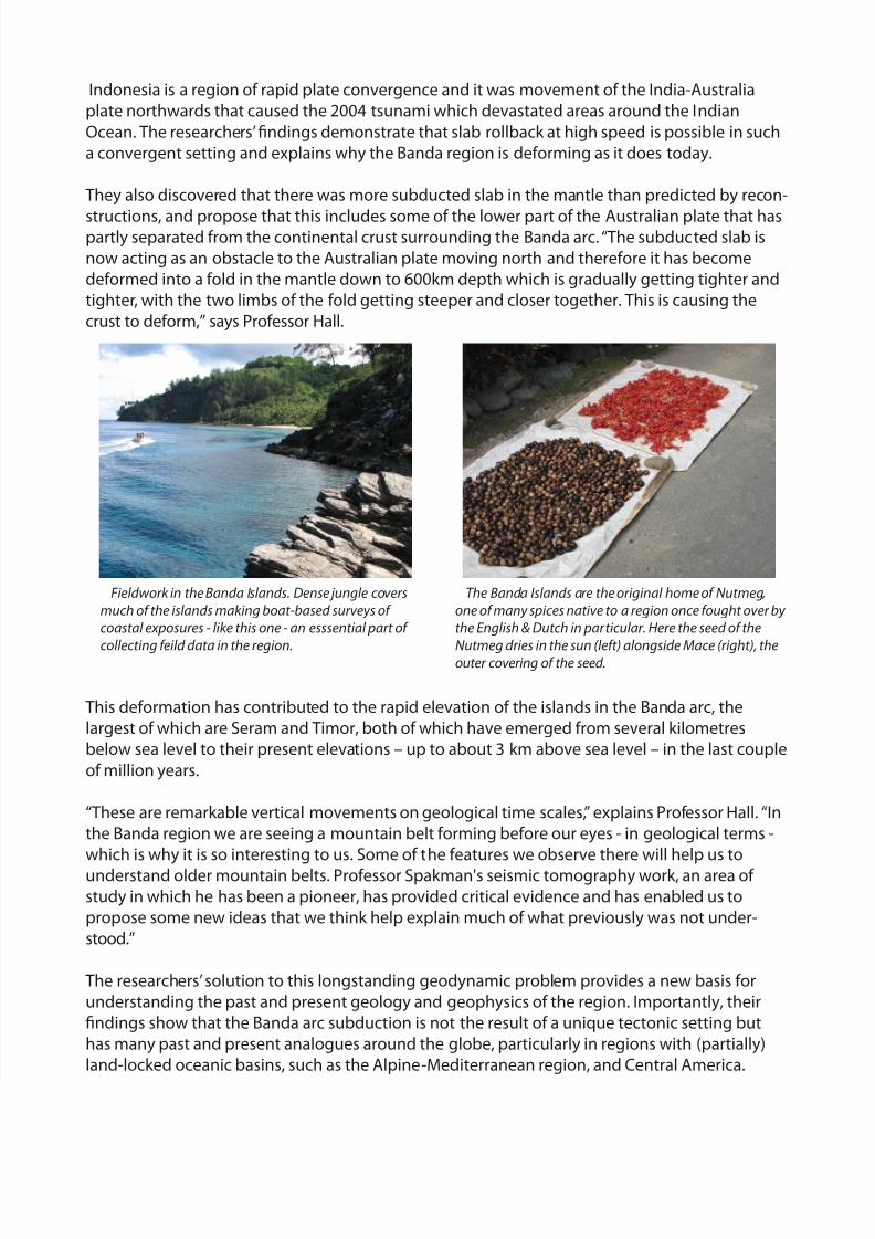
The Banda Islands are the original home of Nutmeg,
one of many spices native to a region once fought over by
the English & Dutch in particular. Here the seed of the
Nutmeg dries in the sun (left) alongside Mace (right), theouter covering of the seed.