METEOROLOGICAL CONDITION OSF THE SCOTT RIVER...
8
Stefan Bartoszewski, Krzysztof Siwek Institute of Earth Sciences Maria Curie-Sklodowska University Lublin, Poland W>prawy Geograficzne na Spitsbergen UMCS, Lublin 1992 METEOROLOGICAL CONDITIONS OF THE SCOTT RIVER OUTFLOW IN THE SUMMER 1990 (WESTERN SPITSBERGEN) The hydrometeorological studies of the NW part of the Wedel Jarlsberg Land (Western Spitsbergen) began during the first Geographical Expedition, M. C. Skłodowska University in 1986. The works carried out in the next years created a 5 year series of observations (Bartoszewski 1987, 1988, 1989, 1991; Czaban 1990; Gluza 1987 a, b, 1988, 1989; Michalczyk 1990; Siwek 1991). The check of the Scott Glacier basin is secured by hydrometrie profile situated in the estuary of the Scott River in the point of ravine by the raised marine terraces 20-30 m a.s.l. The key profile closes the basin of 10.125 km 2 area of which Scott Glacier occupies 5.8 km 2 . Necessity of numerical description of outflow from the basin frozen part made the measurements broader and establishment situation of an additional hydrometrie profile within the ridge of Scott Glacier frontal moraine. In the further description, the profile is called „moraine". It checks the surface outflow from the area of 7.5 km 2 which constitutes 77.3% of the Scott River area. The paper presents the attempt of relating the parameter sizes in the „moraine" profile and some meteorological elements. The main problem was lack of meteorological measurements from the frozen part of basin. As shown in the previous studies (Siwek, Paczos 1990) this region is characterized by topoclimatic conditions different from those occurring in Calypsostranda. Determination of relations between temperature and humidity allows for distinguishing two main topoclimatic units: one of them covers the Calypsost- randa areas up to 120 m a.s.l. and another the areas situated higher (a foot and top zone of Bohlinryggen and Wijkanderberget). The course of this border is modified by orographic conditions. A 36-day measurement series (1 July-5 August, 1990) was subjected to a further analysis. The initial data constituted average values from 6 hour periods and referred to: a flow in the „moraine" profije, air temperature at.2 m height, water vapor pressure, relative humidity, cloudiness and insolation as well as precipitation at the station in Calypsobyen. 31
Transcript of METEOROLOGICAL CONDITION OSF THE SCOTT RIVER...
Stefan Bartoszewski, Krzysztof Siwek Institute of Earth Sciences Maria Curie-Sklodowska University Lublin, Poland
W>prawy Geograficzne na Spitsbergen UMCS, Lublin 1992
METEOROLOGICAL CONDITIONS OF THE SCOTT RIVER OUTFLOW IN THE SUMMER 1990 (WESTERN SPITSBERGEN)
The hydrometeorological studies of the NW part of the Wedel Jarlsberg Land (Western Spitsbergen) began during the first Geographical Expedition, M. C. Skłodowska University in 1986. The works carried out in the next years created a 5 year series of observations (Bartoszewski 1987, 1988, 1989, 1991; Czaban 1990; Gluza 1987 a, b, 1988, 1989; Michalczyk 1990; Siwek 1991).
The check of the Scott Glacier basin is secured by hydrometrie profile situated in the estuary of the Scott River in the point of ravine by the raised marine terraces 20-30 m a.s.l. The key profile closes the basin of 10.125 km2 area of which Scott Glacier occupies 5.8 km2. Necessity of numerical description of outflow from the basin frozen part made the measurements broader and establishment situation of an additional hydrometrie profile within the ridge of Scott Glacier frontal moraine. In the further description, the profile is called „moraine". It checks the surface outflow from the area of 7.5 km2 which constitutes 77.3% of the Scott River area.
The paper presents the attempt of relating the parameter sizes in the „moraine" profile and some meteorological elements. The main problem was lack of meteorological measurements from the frozen part of basin. As shown in the previous studies (Siwek, Paczos 1990) this region is characterized by topoclimatic conditions different from those occurring in Calypsostranda. Determination of relations between temperature and humidity allows for distinguishing two main topoclimatic units: one of them covers the Calypsost-randa areas up to 120 m a.s.l. and another the areas situated higher (a foot and top zone of Bohlinryggen and Wijkanderberget). The course of this border is modified by orographic conditions.
A 36-day measurement series (1 July-5 August, 1990) was subjected to a further analysis. The initial data constituted average values from 6 hour periods and referred to: a flow in the „moraine" profije, air temperature at.2 m height, water vapor pressure, relative humidity, cloudiness and insolation as well as precipitation at the station in Calypsobyen.
31
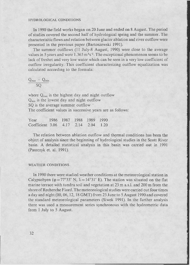
HYDROLOG1CAL CONDITIONS
In 1990 the field works began on 20 June and ended on 8 August. The period of studies covered the second half of hydrological spring and the summer. The characterisitic flows and relation between glacier ablation and river outflow were presented in the previous paper (Bartoszewski 1991).
The summer outflows (11 July-8 August, 1990) were close to the average values in 5 years and were 1.365 m3s"1. The exceptional phenomenon seems to be lack of freshet and very low water which can be seen in a very low coefficient of outflow irregularity. This coefficient characterizing outflow equalization was calculated according to the formula:
Qmax Q m i n
SO
where Qm;iX is the highest day and night outflow Qmin is the lowest day and night outflow SQ is the average summer outflow ' The coefficient values in successive years are as follows:
Year 1986 1987 1988 1989 1990 Coefficient 3.06 4.17 2.14 2.04 1.20
The relation between ablation outflow and thermal conditions has been the object of analysis since the beginning of hydrological studies in the Scott River basin. A detailed statistical analysis in this basin was carried out in 1991 (Paszczyk et. al. 1991).
WEATHER CONDITIONS
In 1990 there were studied weather conditions at the meteorological station in Calypsobyen (<p = 77°33' N, X= 14°31' E). The station was situated on the flat marine terrace with tundra soil and vegetation at 23 m a.s.l. and 200 m from the shore of Recherche Fiord. The meteorological studies were carried out four times a day and night (00, 06,12, 18 GMT) from 23 June to 5 August 1990 and covered the standard meteorological parameters (Siwek 1991). In the further analysis there was used a measurement series synchronous with the hydrometrie data from 1 July to 5 August.
32

TEMPERATURE
The average air temperature daring the whole measurement period was 5.9°C. On individual days the average day and night temperature changed from 2.8°C (1 July — at large cloudiness and strong wind from N W direction) to 8.8°C (29 July when the weather was sunny with slight wind from S direction).
WATER VAPOR PRESSURE
The average day and night vapor pressure calculated for the period of 1 July to 5 August was 7.9 hPa. It changed from 9.4 hPa on 28 and 29 July (highest value) to 6.2 hPa on 1 July (lowest value).
HUMIDITY
The average day and night humidity calculated for the period of 1 July to 5 August was 84.6%. It changed from 72% on 13 July, 3 and 4 August to 96% on 30 July (changeability range 24%). Relative humidity decrease in the first days of August was caused mainly by a local circulation of foehn type.
PRECIPITATION
The sum of precipitation in the measurement period was 11.5 mm and was about six times as low as the sum of potential evaporation which indicates the negative water balance in the area of measurement. There were 9 days with precipitation of > 0.1 mm and only 3 days with ^ 1.0 mm. There was not even one day with the sum of precipitation of ^ 10.0 mm. The highest precipitation 5.5 mm was recorded on 14 July.
CLOUDINESS AND INSOLATION
The extent of sky cloudiness was expressed in the scale from 0 to 10. The average day and night cloudiness calculated for the period of 1 July to 5 August was 8.7 degree. During the whole — period there was not one sunny day (the average day and night cloudiness ^ 2.0) but there were 26 cloudy days (the average day and night cloudiness ^ 8.0) which constituted 72% of all measurement days.
The sum of absolute insolation was 120.4 hours which constitutes 13.9% of
33

possible insolation. On the average there were 3.3 sunny hours a day and night. The highest value of insolation was on 2 August (11.8 hrs), but were 12 days without the sun.
The course of the Scott River outflow and some meteorological elements are presented in Figs. 1 and 2.
CHANGES OF METEOROLOGICAL ELEMENTS AND OUTFLOWS OF SCOTT RIVER IN 1990
Some of the analyzed elements form autocorrelated sequences i.e. have a tendency towards correlation with observations close in time. A tendency towards a cyclic day and night sequence is especially clear for air temperature course (Fig. 3).
The statistical relations of the studied quantities are illustrated by the matrix of correlation among elements (Tab. 1) which enables the analysis of elementary relations of hydrometeorological elements and obtaining quantitative measure of similary among variable. With existing numbers (144 pairs of elements) and assumption of significance 0.1% the critical value of correlation coefficient is r=0.28. The coefficients showing the relations of air temperature and water vapor pressure, water vapor pressure and relative humidity, flow and air temperature, flow and water vapor pressure are essential at the assumed level. The highest positive correlation coefficient for the whole matrix r = 0.63 connects two variables: temperature and water vapor pressure. A little lower coefficient r = 0.55 occured between water vapor pressure and air relative humidity.
The average six hour flows of Scott River in the profile closing the mountain part of the basin are conditioned by air temperature r = 0.52 and water vapor pressure r = 0.42. The factor transforming the temperature — flow relation was ablation outflow of foehn origin taking place on the turn of I and II decades of July and in the first pentad of August.
Topoclimatic differentiation of Scott Glacier basin causes that some meteoro-logical phenomena are of local character (particulary in the frozen part of basin) and are not recorded at the meteorological station in Calypsobyen.
As the other analyzed meteorological elements: precipitation, insolation, cloudiness, their influence on the size of Scott River outflow was not observed in the summer 1990. Lack of relation between outflow and precipitation is noticeable. The studies carried out in the period of 1986-89 showed a significant influence of summer precipitation on outflow formation, particulary on extreme freshet formation. Lack of this dependence in 1990 results from a non-typical distribution of precipitation within five years 1986-1990. The summer in 1990 was exceptionally dry with large cloudiness and high relative humidity. The sum of precipitation in this period was only 11.5 mm i.e. less than maximum day and night sums in the previous years. In the most cases the precipitation was
34

0.1 mm. It has no „effective precipitation" character and does not cause outflow increase.
The analysis of hydrometeorological data from the summer 1990 showed that statistical similarity between flow and some meteorological elements was largely caused by choice of basic time period and increased with its extension. In the case of most strongly correlated elements i.e. temperature of air and flow, passing from six hour to twenty four hour periods (day and night) causes increase in the correlation coefficient from 0.51 to 0.64.
Translated by Maria Charmas
REFERENCES
Bartoszewski S., 1987: Dynamika odpływu powierzchniowego w zlewniach rzek lodowcowych Scotta, Blomli i Tjórn podczas lata 1986 (Spitsbergen Zachodni). XIV Sympozjum Polarne, Lublin.
Bartoszewski S., 1988: Warunki kształtowania się odpływu w zlewni rzeki Scotta (Zachodni Spitsbergen). Wyprawy Geograficzne na Spitsbergen UMCS Lublin.
Bartoszewski S., 1989: Charakterystyka odpływu ze zlewni lodowca Scotta (Zachodni Spitsber-gen). Wyprawy Geograficzne na Spitsbergen. UMCS Lublin.
Bartoszewski S., 1991: Ablation of Scott Glacier and its role in river llow formation. Wyprawy Geograficzne na Spitsbergen, UMCS Lublin.
Czaban P., 1990: Weather conditions in Calypsobyen in the summer 1989. Wyprawy Geograficz-ne na Spitsbergen, UMCS Lublin.
Gluza A., 1987a: Prędkość i kierunek wiatru w lipcu i sierpniu 1986 r. w Calypsobyen (Zachodni Spitsbergen). XIV Sympozjum Polarne, Lublin.
Gluza A.,\ 987b: Zachmurzenie i częstość występowania poszczególnych rodzajów chmur w lipcu i sierpniu 1986 r. w Calypsobyen (Zachodni Spitsbergen). XIV Sympozjum Polarne, Lublin.
Gluza A., 1988: Warunki pogodowe w sezonie letnim 1987 w Calypsobyen. Wyprawy Geograficzne na Spitsbergen. UMCS Lublin.
Gluza A., 1989: Warunki pogodowe w sezonie letnim 1988 w Calypsobyen. Wyprawy Geograficzne na Spitsbergen. UMCS Lublin.
Michalczyk Z., 1990: Hydrographical characteristic of Calypsostranda. Wyprawy geograficzne na Spitsbergen. UMCS Lublin.
Paszczyk J., Michalczyk Z., Bartoszewski S., 1991: Analysis of the Scott River flow in 1989 (West Spitsbergen). Wyprawy Geograficzne na Spitsbergen, UMCS Lublin.
Siwek К., Paczos S., 1990: Differentiation of Calypsostranda thermal and humidity conditions in the summer 1989 (Western Spitsbergen). Wyprawy Geograficzne na Spitsbergen. UMCS Lublin.
Siwek К., 1991: The weather conditions in Calypsobyen in the summer 1990. Wyprawy Geograficzne na Spitsbergen. UMCS Lublin.
STRESZCZENIE
W opracowaniu przedstawiono zależność wielkości odpływu rzeki Scotta od przebiegu wy-branych elementów meteorologicznych w Calypsobyen podczas sezonu letniego 1990 r. Związki statystyczne wielkości przepływu, temperatury powietrza, prężności pary wodnej, wilgotności względnej, opadów atmosferycznych oraz zachmurzenia i usłonecznienia przedstawia macierz korelacji (Tab. 1). Średnie 6-godzinne przepływy rzeki Scotta w profilu zamykającym lodowcową część zlewni uwarunkowane są przede wszystkim temperaturą powietrza. Nietypowy na tle wielolecia rozkład opadów letnich spowodował brak zależności między wielkością opadu i odpływu.
35
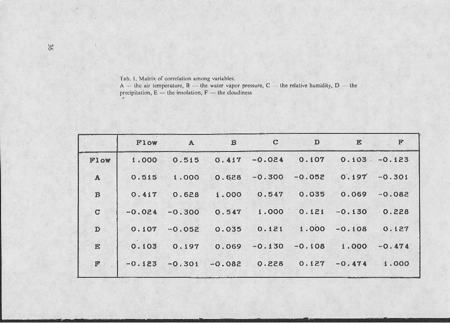
Tab. 1. Matrix of correlation among variables. A — the air temperature, В — the water vapor pressure, С precipitation, E — the insolation, F — the cloudiness
— the relative humidity, D — the
F l o w A В С D Б F
F l o w 1 .ООО О . 5 1 5 О . 4 1 7 - 0 . 0 2 4 0 . 1 0 7 О . 1 0 3 - О . 1 2 3
A 0 . 5 1 5 1 .ООО О . 6 2 8 - 0 . 3 0 0 - 0 . 0 5 2 O'. 1 9 7 - 0 . 3 0 1
В 0 . 4 1 7 О . 6 2 8 1 .ООО 0 . 5 4 7 0 . 0 3 5 0 . 0 6 9 - О . 0 8 2
С - 0 . 0 2 4 - О . З О О 0 . 5 4 7 1 .ООО 0 . 1 2 1 - 0 . 1 3 0 0 . 2 2 8
D О. 1 0 7 - 0 . 0 5 2 О . 0 3 5 0 . 1 2 1 1 .ООО - О . 1 0 8 0 . 1 2 7
E 0 . 1 0 3 0 . 1 9 7 0 . 0 6 9 - 0 . 1 3 0 - О . 1 0 8 1 .ООО - 0 . 4 7 4
F - 0 . 1 2 3 - О . 3 0 1 - О . 0 8 2 0 . 2 2 8 0 . 1 2 7 - 0 . 4 7 4 1 .ООО
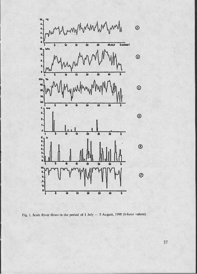
Fig. 1. Scott River flows in the period of 1 July — 5 August, 1990 (6-hour values).
37

1 .
i 15
—i— 20 10 25 30 JULY 5 AUGUST
Fig. 2. Course of some meteorological elements in Calypsobyen in the period of 1 July — 5 August, 1990 (6-hour values). A the air temperature, В — the water vapor pressure, С — the relative humidity, D — the precipitation, E — the insolation, F — the cloudiness.
1 „ Г
Q5.
п[1ппП11|1ппПп»пПп„п1]ПпП11ПпППп_,пп пПп^пп
-as.
- i —I— 30
I 40 10 20 50
Fig. 3. Autocorrelation of air temperature.
38