GPS/GLONASS PRECISE POINT POSITIONING WITH IGS … · GPS/GLONASS PRECISE POINT POSITIONING WITH...
13
Acta Geodyn. Geomater., Vol. 13, No. 1 (181), 69–81, 2016 DOI: 10.13168/AGG.2015.0047 journal homepage: http://www.irsm.cas.cz/acta ORIGINAL PAPER GPS/GLONASS PRECISE POINT POSITIONING WITH IGS REAL-TIME SERVICE PRODUCTS Grzegorz KRZAN * and Paweł PRZESTRZELSKI University of Warmia and Mazury in Olsztyn, Oczapowskiego 2, 10-719 Olsztyn, Poland *Corresponding author‘s e-mail: [email protected] ABSTRACT The International GNSS Service (IGS) in April 2013 started real-time services (IGS-RTS) to provide access to high-precision products such as orbits, clocks and code observation errors. Products containing corrections are delivered to users by the RTCM data stream in real-time. The IGS03 stream which contains corrections for GPS and GLONASS systems is currently in the experimental stage and positioning with its use is still insufficiently investigated in terms of accuracy and reliability of positioning. In this paper we evaluate the impact of the IGS-RTS streams on positioning. In research section we presented the results of the processing of two-week satellite observations registered at five IGS stations located at different latitudes, using the three IGS-RTS streams: IGS01, IGS02 and IGS03, and BKG Ntrip Client (BNC). Post-processing involved the utilization of GPS and GPS+GLONASS signals. Subsequently we analyzed the real-time position determination of MARS IGS station using IGS03 data stream, which showed one of the best performance during the development of observation in post-processing mode. In analysis we applied approach showing the probability of achieving results within the assumed ranges of accuracy (<1.0 m, <0.5 m, <0.2 m, <0.1m). This approach allows the estimation of potential applications, depending on the expected accuracy of positioning. ARTICLE INFO Article history: Received 20 April 2015 Accepted 16 September 2015 Available online 7 October 2015 Keywords: Real-time PPP IGS RTS GPS GLONASS (PPP) strategy. It does not require a direct set of observations from a single station or station network, but instead needs high quality external corrections. Over the last decade, the PPP has proven to be a very useful tool and found application in various fields (e.g. monitoring of reference stations, time and frequency transfer or signal analysis (Zumberge et al., 1997; Defraigne et al., 2007; Chen et al., 2009; Leandro et al., 2011)). For this reason, it has been investigated by scientists all around the world. Various research facilities have investigated PPP performance using their own applications or open- source projects (Salazar et al., 2010; Laurichesse, 2011; Li et al., 2013). On the internet one can find automatic services enabling position estimation in the PPP mode (Dawidowicz et al., 2014). Currently, PPP is conducted mainly with GPS, but other satellite navigation systems are being included into the process of position estimation, i.e. GLONASS, Galileo, BeiDou (Juan et al., 2012; Cai and Gao, 2013; Li et al., 2013). The main challenge of PPP is still that it typically requires about 30 min to obtain centimeter- level accuracy or to succeed in the first ambiguity- fixing (Li and Zhang, 2014). In most cases dual frequency code and carrier phase observations and ionosphere-free combination are utilized to obtain precise coordinates. Thus, ionospheric delays are not taken into consideration, INTRODUCTION Global Navigation Satellite Systems (GNSS) are used in many areas of our everyday life, not only in navigation, as its acronym states, but also in applications requiring the highest accuracy, such as surveying, deformation monitoring and atmospheric research (Bakuła, 2013; Wielgosz et al., 2013; Baryła et al., 2014). Among all of the known precise GNSS positioning strategies two groups can be distinguished: differenced and un-differenced. The former method includes relative positioning strategy, e.g. Real Time Kinematic (RTK). In this case the process of coordinate estimation requires at least two (or more) receivers operating simultaneously. Observation differences (single, double and triple) formulated between receivers and satellites serve to eliminate or mitigate many biases associated with GNSS positioning (Misra and Enge, 2011). To achieve the highest accuracy satellite measurements are usually conducted in unobstructed areas. However the use of an appropriate surveying technology can obtain centimeter-level accuracy even in environments with a high degree of difficulty for satellite access (Bakuła et al., 2015). Nevertheless, in both cases users are limited by the distance to the closest reference station. To overcome this issue the un-differenced positioning strategies are being developed, and one of widely researched is the Precise Point Positioning Cite this article as: Krzan G, Przestrzelski P: GPS/Glonass precise point positioning with IGS Real-time service product, Acta Geodyn. Geomater. 13 (1) (2016) 69–81. DOI: 10.13168/AGG.2015.0047
Transcript of GPS/GLONASS PRECISE POINT POSITIONING WITH IGS … · GPS/GLONASS PRECISE POINT POSITIONING WITH...
Acta Geodyn. Geomater., Vol. 13, No. 1 (181), 69–81, 2016
DOI: 10.13168/AGG.2015.0047
journal homepage: http://www.irsm.cas.cz/acta
ORIGINAL PAPER
q
GPS/GLONASS PRECISE POINT POSITIONING WITH IGS REAL-TIME SERVICE PRODUCTS
Grzegorz KRZAN * and Paweł PRZESTRZELSKI
University of Warmia and Mazury in Olsztyn, Oczapowskiego 2, 10-719 Olsztyn, Poland
*Corresponding author‘s e-mail: [email protected]
ABSTRACT
The International GNSS Service (IGS) in April 2013 started real-time services (IGS-RTS) toprovide access to high-precision products such as orbits, clocks and code observation errors.Products containing corrections are delivered to users by the RTCM data stream in real-time.The IGS03 stream which contains corrections for GPS and GLONASS systems is currently inthe experimental stage and positioning with its use is still insufficiently investigated in terms ofaccuracy and reliability of positioning. In this paper we evaluate the impact of the IGS-RTS streams on positioning. In research sectionwe presented the results of the processing of two-week satellite observations registered at fiveIGS stations located at different latitudes, using the three IGS-RTS streams: IGS01, IGS02 andIGS03, and BKG Ntrip Client (BNC). Post-processing involved the utilization of GPS andGPS+GLONASS signals. Subsequently we analyzed the real-time position determination ofMARS IGS station using IGS03 data stream, which showed one of the best performance duringthe development of observation in post-processing mode. In analysis we applied approachshowing the probability of achieving results within the assumed ranges of accuracy (<1.0 m,<0.5 m, <0.2 m, <0.1m). This approach allows the estimation of potential applications,depending on the expected accuracy of positioning.
ARTICLE INFO
Article history:
Received 20 April 2015 Accepted 16 September 2015 Available online 7 October 2015
Keywords: Real-time PPP IGS RTS GPS GLONASS
(PPP) strategy. It does not require a direct set ofobservations from a single station or station network,but instead needs high quality external corrections.
Over the last decade, the PPP has proven to bea very useful tool and found application in variousfields (e.g. monitoring of reference stations, time andfrequency transfer or signal analysis (Zumberge et al.,1997; Defraigne et al., 2007; Chen et al., 2009;Leandro et al., 2011)). For this reason, it has beeninvestigated by scientists all around the world.Various research facilities have investigated PPPperformance using their own applications or open-source projects (Salazar et al., 2010; Laurichesse,2011; Li et al., 2013). On the internet one can findautomatic services enabling position estimation in thePPP mode (Dawidowicz et al., 2014). Currently, PPPis conducted mainly with GPS, but other satellitenavigation systems are being included into the processof position estimation, i.e. GLONASS, Galileo,BeiDou (Juan et al., 2012; Cai and Gao, 2013; Li etal., 2013). The main challenge of PPP is still that ittypically requires about 30 min to obtain centimeter-level accuracy or to succeed in the first ambiguity-fixing (Li and Zhang, 2014).
In most cases dual frequency code and carrierphase observations and ionosphere-free combinationare utilized to obtain precise coordinates. Thus,ionospheric delays are not taken into consideration,
INTRODUCTION
Global Navigation Satellite Systems (GNSS) areused in many areas of our everyday life, not only innavigation, as its acronym states, but also inapplications requiring the highest accuracy, such assurveying, deformation monitoring and atmosphericresearch (Bakuła, 2013; Wielgosz et al., 2013; Baryłaet al., 2014). Among all of the known precise GNSSpositioning strategies two groups can bedistinguished: differenced and un-differenced. Theformer method includes relative positioning strategy,e.g. Real Time Kinematic (RTK). In this case theprocess of coordinate estimation requires at least two(or more) receivers operating simultaneously.Observation differences (single, double and triple)formulated between receivers and satellites serve toeliminate or mitigate many biases associated withGNSS positioning (Misra and Enge, 2011). Toachieve the highest accuracy satellite measurementsare usually conducted in unobstructed areas. Howeverthe use of an appropriate surveying technology canobtain centimeter-level accuracy even in environmentswith a high degree of difficulty for satellite access(Bakuła et al., 2015). Nevertheless, in both cases usersare limited by the distance to the closest referencestation. To overcome this issue the un-differencedpositioning strategies are being developed, and one ofwidely researched is the Precise Point Positioning
Cite this article as: Krzan G, Przestrzelski P: GPS/Glonass precise point positioning with IGS Real-time service product, Acta Geodyn.Geomater. 13 (1) (2016) 69–81. DOI: 10.13168/AGG.2015.0047
G. Krzan and P. Przestrzelski
70
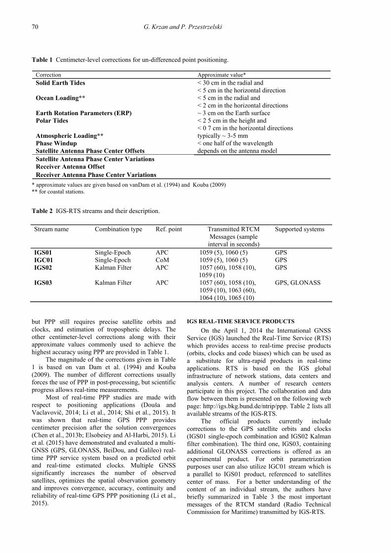
Table 1 Centimeter-level corrections for un-differenced point positioning.
Correction Approximate value*
Solid Earth Tides < 30 cm in the radial and < 5 cm in the horizontal direction
Ocean Loading** < 5 cm in the radial and < 2 cm in the horizontal directions
Earth Rotation Parameters (ERP) ~ 3 cm on the Earth surface Polar Tides < 2 5 cm in the height and
< 0 7 cm in the horizontal directions Atmospheric Loading** typically ~ 3-5 mm Phase Windup < one half of the wavelength Satellite Antenna Phase Center Offsets depends on the antenna model Satellite Antenna Phase Center Variations Receiver Antenna Offset
Receiver Antenna Phase Center Variations
* approximate values are given based on vanDam et al. (1994) and Kouba (2009) ** for coastal stations.
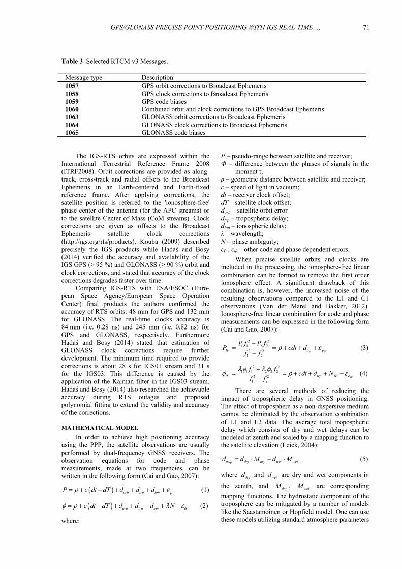
Table 2 IGS-RTS streams and their description.
Stream name Combination type Ref. point Transmitted RTCM Messages (sample
interval in seconds)
Supported systems
IGS01 Single-Epoch APC 1059 (5), 1060 (5) GPS IGC01 Single-Epoch CoM 1059 (5), 1060 (5) GPS IGS02 Kalman Filter APC 1057 (60), 1058 (10),
1059 (10) GPS
IGS03 Kalman Filter APC 1057 (60), 1058 (10), 1059 (10), 1063 (60), 1064 (10), 1065 (10)
GPS, GLONASS
IGS REAL-TIME SERVICE PRODUCTS
On the April 1, 2014 the International GNSSService (IGS) launched the Real-Time Service (RTS)which provides access to real-time precise products(orbits, clocks and code biases) which can be used asa substitute for ultra-rapid products in real-timeapplications. RTS is based on the IGS globalinfrastructure of network stations, data centers andanalysis centers. A number of research centersparticipate in this project. The collaboration and dataflow between them is presented on the following webpage: http://igs.bkg.bund.de/ntrip/ppp. Table 2 lists allavailable streams of the IGS-RTS.
The official products currently includecorrections to the GPS satellite orbits and clocks(IGS01 single-epoch combination and IGS02 Kalmanfilter combination). The third one, IGS03, containingadditional GLONASS corrections is offered as anexperimental product. For orbit parametrizationpurposes user can also utilize IGC01 stream which isa parallel to IGS01 product, referenced to satellitescenter of mass. For a better understanding of thecontent of an individual stream, the authors havebriefly summarized in Table 3 the most importantmessages of the RTCM standard (Radio TechnicalCommission for Maritime) transmitted by IGS-RTS.
but PPP still requires precise satellite orbits andclocks, and estimation of tropospheric delays. Theother centimeter-level corrections along with theirapproximate values commonly used to achieve thehighest accuracy using PPP are provided in Table 1.
The magnitude of the corrections given in Table1 is based on van Dam et al. (1994) and Kouba(2009). The number of different corrections usuallyforces the use of PPP in post-processing, but scientificprogress allows real-time measurements.
Most of real-time PPP studies are made withrespect to positioning applications (Douša andVaclavovič, 2014; Li et al., 2014; Shi et al., 2015). Itwas shown that real-time GPS PPP providescentimeter precision after the solution convergences(Chen et al., 2013b; Elsobeiey and Al-Harbi, 2015). Liet al. (2015) have demonstrated and evaluated a multi-GNSS (GPS, GLONASS, BeiDou, and Galileo) real-time PPP service system based on a predicted orbitand real-time estimated clocks. Multiple GNSSsignificantly increases the number of observedsatellites, optimizes the spatial observation geometryand improves convergence, accuracy, continuity andreliability of real-time GPS PPP positioning (Li et al.,2015).
GPS/GLONASS PRECISE POINT POSITIONING WITH IGS REAL-TIME … .
71
Table 3 Selected RTCM v3 Messages.
Message type Description 1057 GPS orbit corrections to Broadcast Ephemeris 1058 GPS clock corrections to Broadcast Ephemeris 1059 GPS code biases 1060 Combined orbit and clock corrections to GPS Broadcast Ephemeris 1063 GLONASS orbit corrections to Broadcast Ephemeris 1064 GLONASS clock corrections to Broadcast Ephemeris 1065 GLONASS code biases
P – pseudo-range between satellite and receiver; Φ – difference between the phases of signals in the
moment t; ρ – geometric distance between satellite and receiver; c – speed of light in vacuum; dt – receiver clock offset; dT – satellite clock offset; dorb – satellite orbit error dtrp – tropospheric delay; dion – ionospheric delay; λ – wavelength; N – phase ambiguity; εP , εΦ – other code and phase dependent errors.
When precise satellite orbits and clocks areincluded in the processing, the ionosphere-free linearcombination can be formed to remove the first orderionosphere effect. A significant drawback of thiscombination is, however, the increased noise of theresulting observations compared to the L1 and C1observations (Van der Marel and Bakker, 2012).Ionosphere-free linear combination for code and phasemeasurements can be expressed in the following form(Cai and Gao, 2007):
2 21 1 2 2
2 21 2
lFIF trp p
P f P fP cdt d
f fρ ε−
= = + + +−
(3)
2 21 1 1 2 2 2
2 21 2
IFIF trp IF
f fcdt d N
f f φλ φ λ φφ ρ ε−
= = + + + +−
(4)
There are several methods of reducing theimpact of tropospheric delay in GNSS positioning.The effect of troposphere as a non-dispersive mediumcannot be eliminated by the observation combinationof L1 and L2 data. The average total troposphericdelay which consists of dry and wet delays can bemodeled at zenith and scaled by a mapping function tothe satellite elevation (Leick, 2004):
trop dry dry wet wetd d M d M= ⋅ + ⋅ (5)
where dryd and wetd are dry and wet components in
the zenith, and dryM , wetM are corresponding
mapping functions. The hydrostatic component of thetroposphere can be mitigated by a number of modelslike the Saastamoinen or Hopfield model. One can usethese models utilizing standard atmosphere parameters
The IGS-RTS orbits are expressed within theInternational Terrestrial Reference Frame 2008(ITRF2008). Orbit corrections are provided as along-track, cross-track and radial offsets to the BroadcastEphemeris in an Earth-centered and Earth-fixedreference frame. After applying corrections, thesatellite position is referred to the 'ionosphere-free'phase center of the antenna (for the APC streams) orto the satellite Center of Mass (CoM streams). Clockcorrections are given as offsets to the BroadcastEphemeris satellite clock corrections(http://igs.org/rts/products). Kouba (2009) describedprecisely the IGS products while Hadaś and Bosy(2014) verified the accuracy and availability of theIGS GPS (> 95 %) and GLONASS (> 90 %) orbit andclock corrections, and stated that accuracy of the clockcorrections degrades faster over time.
Comparing IGS-RTS with ESA/ESOC (Euro-pean Space Agency/European Space OperationCenter) final products the authors confirmed theaccuracy of RTS orbits: 48 mm for GPS and 132 mmfor GLONASS. The real-time clocks accuracy is84 mm (i.e. 0.28 ns) and 245 mm (i.e. 0.82 ns) forGPS and GLONASS, respectively. FurthermoreHadaś and Bosy (2014) stated that estimation ofGLONASS clock corrections require furtherdevelopment. The minimum time required to providecorrections is about 28 s for IGS01 stream and 31 sfor the IGS03. This difference is caused by theapplication of the Kalman filter in the IGS03 stream.Hadaś and Bosy (2014) also researched the achievableaccuracy during RTS outages and proposedpolynomial fitting to extend the validity and accuracyof the corrections.
MATHEMATICAL MODEL
In order to achieve high positioning accuracyusing the PPP, the satellite observations are usuallyperformed by dual-frequency GNSS receivers. Theobservation equations for code and phasemeasurements, made at two frequencies, can bewritten in the following form (Cai and Gao, 2007):
( ) orb trp ion pP c dt dT d d dρ ε= + − + + + + (1)
( ) orb trp ionc dt dT d d d N φφ ρ λ ε= + − + + − + + (2)
where:
G. Krzan and P. Przestrzelski
72
2012; Chen et al., 2013a; Shi et al., 2013;Montenbruck and Hauschild, 2014; Guo et al., 2015).ISB and DCB phenomena have been widelyresearched in recent years. The one that causes biggestdifficulties in GPS/GLONASS integration isfrequency-dependent ICB. The effects of receiver ICBare different from channel-to-channel of the samereceiver (Wanninger, 2012). Moreover receiver ICBsin code and carrier phase measurements are different,and for this reason are classified into code receiverICB and carrier-phase receiver ICB, respectively(Yamada et al., 2010; Kim et al., 2013). Most ofresearches in this field are focused on relativepositioning (Wanninger and Wallstab-Freitag, 2007;Yamada et al., 2010; Al-Shaery et al., 2013; Kim etal., 2013). However, with growing interest in the PPPfurther efforts have been made to estimate theinfluence of ICB on point positioning (Reussner andWanninger, 2011; Chuang et al., 2013).
In addition to the PPP employing twofrequencies, it is possible to process single frequencymeasurements (van Bree and Tiberius, 2012).However, this requires the use of different models tomitigate the influence of individual factors degradingthe accuracy of positioning (in particular, theionospheric delay), and has a significantly loweraccuracy in relation to the dual-frequency approach(Dawidowicz et al., 2014).
METHODOLOGY OF STUDIES
This paper presents an analysis of the accuracyof a single GNSS receiver position determinationusing IGS Real-time Services and Bundesamt für
Kartographie und Geodäsie (BKG) Ntrip Client(BNC) version 2.10. The BNC2.10 is an Open Sourcemulti-stream client program designed for a variety ofreal-time GNSS applications provided by FederalAgency for Cartography and Geodesy. Between 22ndMay and 5th June 2014 (142-156 days of year (DOY)2014) we registered three streams of corrections:IGS01, IGS02 and IGS03. We then used thesecorrections to post-process the satellite observationsfrom five randomly chosen IGS stations located at
or by entering into model surface meteorological datafrom global or regional numerical meteorologicalmodels such as European Centre for Medium-RangeWeather Forecast (ECMWF), the CoupledOcean/Atmosphere Mesoscale Prediction System(COAMPS) or Global Pressure and Temperature(GPT) (Boehm et al., 2007; Kalita et al., 2014). In thisarticle, we will describe only the Saastamoinen model,because it is used in the processing of observationusing the BKG program. The final expression for the Zenith Hydrostatic Delay,submitted in the works of Saastamoinen (1972) andDavis (1985) can be written as:
( ) ( )7 00.0022768 5 10
,dry
Pd
g Hϕ−= ± ⋅ ⋅ (6)
where 0P is the total ground pressure and
( ),g Hϕ is used to model the variations of
acceleration due to the gravity in the function oflatitude φ and altitude H of the station. Although theeffect of the hydrostatic component ranges from 1.5 mto 2.6 m and represents 90% of total zenith delay (Jinet al., 2007) it can be easily modeled by determininga priori models. The wet component of troposphericdelay related to the amount of water vapor along thesignal track is significantly more difficult to model(Kalita et al., 2014). It ranges from 0 to 30 cm and inundifferenced GNSS strategies, it can be estimated asan additional parameter during the processing. Ahmedet al. (2014) have investigated the estimatedtroposphere parameters using IGS-RTS and differentPPP software packages.
A separate issue related to the positioning usingthe multi-GNSS approach are intersystem biaseswhose calibration is a minimum requirement of theinteroperability of multiple GNSS (Wang et al., 2011;Torre and Caporali, 2014). Thus precise GNSSpositioning requires some inter-system and inter-frequency corrections to be included. The formerinvolves the well-known Inter-System Bias (ISB),whereas the latter includes Differential Code Biases(DCB) and Inter-Channel Biases (ICB) (Wanninger,
Fig. 1 Distribution of IGS stations used in research.
GPS/GLONASS PRECISE POINT POSITIONING WITH IGS REAL-TIME … .
73
Table 4 IGS stations used in the processing and their parameters.
CAS1 DARW KIRU MARS NTUS
x -901776.137 -4091359.407 2251420.639 4630532.633 -1508023.083
y 2409383.268 4684606.499 862817.325 433946.491 6195576.583
z -5816748.495 -1408579.454 5885476.803 4350142.829 148799.351 latitude 66°17’0.0967” S 12°50’37.3212” S 67°51’26.4696” N 43°16’43.5756”
N 1°20’44.8858” N
longitude 110°31’10.9425” E
131°07’57.8711” E
20°58’6.4216” E 5°21’13.6417” E 103°40’47.8549” E
height [m] 22.454 125.100 391.049 61.816 75.436 elevation
cut off 0° 0° 0° 0° 0° *
receiver TRIMBLE NETR9
LEICA GRX1200GGPRO
SEPTENTRIO POLARX4
LEICA GR25 LEICA GRX1200GGPRO
antenna LEIAR25.R3 LEIT
ASH700936D_M NONE
SEPCHOKE_MC SPKE
TRM57971.00 NONE
LEIAT504GG NONE
* The value specified in the station log. The actual value obtained in the tests is 10°.
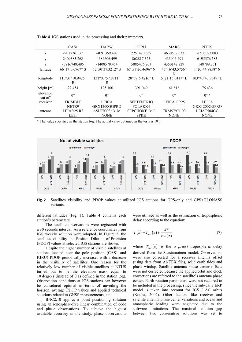
Fig. 2 Satellites visibility and PDOP values at utilized IGS stations for GPS-only and GPS+GLONASSvariants.
were utilized as well as the estimation of troposphericdelay according to the equation:
( ) ( ) ( )cosapr
dTT s T s
z= + (7)
where ( )aprT s is the a priori tropospheric delay
derived from the Saastamoinen model. Observationswere also corrected for a receiver antenna offset(using data from ANTEX file), solid earth tides andphase windup. Satellite antenna phase center offsetswere not corrected because the applied orbit and clockcorrections are referred to the satellite’s antenna phasecenter. Earth rotation parameters were not required tobe included in the processing, since the sub-daily ERPmodel is taken into account for IGS / AC orbits(Kouba, 2002). Other factors, like receiver andsatellite antenna phase center variations and ocean andatmospheric loading were neglected due to thesoftware limitations. The maximal solution gapbetween two consecutive solutions was set to
different latitudes (Fig. 1). Table 4 contains eachstation’s parameters.
The satellite observations were registered witha 30 seconds interval. As a reference coordinates fromIGS weekly solution were adopted. In Figure 2, thesatellites visibility and Position Dilution of Precision(PDOP) values at selected IGS stations are shown.
Despite the higher number of visible satellites atstations located near the pole position (CAS1 andKIRU) PDOP periodically increases with a decreasein the visibility of satellites. One reason for therelatively low number of visible satellites at NTUSturned out to be the elevation mask equal to10 degrees (instead of 0 as defined in the station log).Observation conditions at IGS stations can howeverbe considered optimal in terms of unveiling thehorizon, average PDOP values and applied technicalsolutions related to GNSS measurements, etc.
BNC2.10 applies a point positioning solutionusing an ionosphere-free linear combination of codeand phase observations. To achieve the highestavailable accuracy in the study, phase observations
G. Krzan and P. Przestrzelski
74
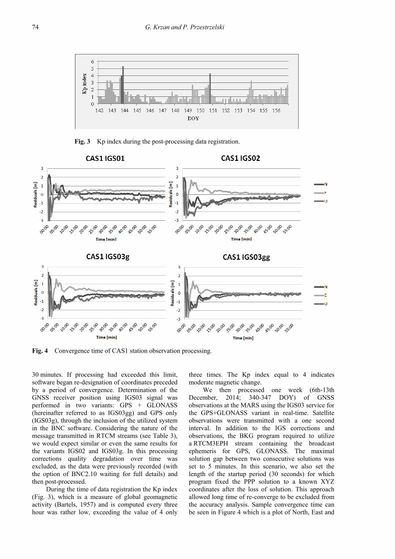
Fig. 3 Kp index during the post-processing data registration.
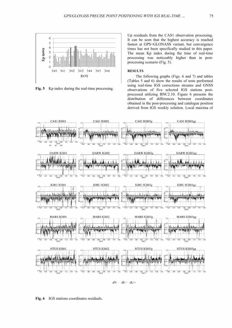
Fig. 4 Convergence time of CAS1 station observation processing.
three times. The Kp index equal to 4 indicatesmoderate magnetic change.
We then processed one week (6th-13thDecember, 2014; 340-347 DOY) of GNSSobservations at the MARS using the IGS03 service forthe GPS+GLONASS variant in real-time. Satelliteobservations were transmitted with a one secondinterval. In addition to the IGS corrections andobservations, the BKG program required to utilizea RTCM3EPH stream containing the broadcastephemeris for GPS, GLONASS. The maximalsolution gap between two consecutive solutions wasset to 5 minutes. In this scenario, we also set thelength of the startup period (30 seconds) for whichprogram fixed the PPP solution to a known XYZcoordinates after the loss of solution. This approachallowed long time of re-converge to be excluded fromthe accuracy analysis. Sample convergence time canbe seen in Figure 4 which is a plot of North, East and
30 minutes. If processing had exceeded this limit,software began re-designation of coordinates precededby a period of convergence. Determination of theGNSS receiver position using IGS03 signal wasperformed in two variants: GPS + GLONASS(hereinafter referred to as IGS03gg) and GPS only(IGS03g), through the inclusion of the utilized systemin the BNC software. Considering the nature of themessage transmitted in RTCM streams (see Table 3),we would expect similar or even the same results forthe variants IGS02 and IGS03g. In this processingcorrections quality degradation over time wasexcluded, as the data were previously recorded (withthe option of BNC2.10 waiting for full details) andthen post-processed.
During the time of data registration the Kp index(Fig. 3), which is a measure of global geomagneticactivity (Bartels, 1957) and is computed every threehour was rather low, exceeding the value of 4 only
GPS/GLONASS PRECISE POINT POSITIONING WITH IGS REAL-TIME … .
75
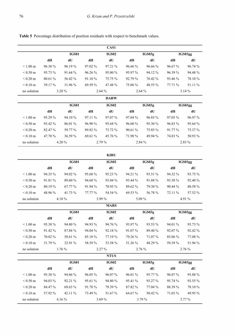
Up residuals from the CAS1 observation processing.It can be seen that the highest accuracy is reachedfastest at GPS+GLONASS variant, but convergencetimes has not been specifically studied in this paper.The mean Kp index during the time of real-timeprocessing was noticeably higher than in post-processing scenario (Fig. 5).
RESULTS
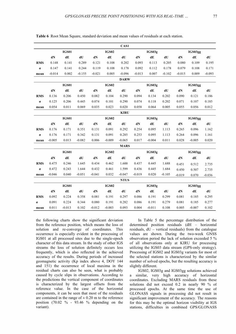
The following graphs (Figs. 6 and 7) and tables(Tables 5 and 6) show the results of tests performedusing real-time IGS corrections streams and GNSSobservations of five selected IGS stations post-processed utilizing BNC2.10. Figure 6 presents thedistribution of differences between coordinatesobtained in the post-processing and catalogue positionderived from IGS weekly solution. Local maxima of
Fig. 5 Kp index during the real-time processing.
Fig. 6 IGS stations coordinates residuals.
G. Krzan and P. Przestrzelski
76
Table 5 Percentage distribution of position residuals with respect to benchmark values.
CAS1
IGS01 IGS02 IGS03g IGS03gg
dH dU dH dU dH dU dH dU
< 1.00 m 96.38 % 96.19 % 97.02 % 97.21 % 96.66 % 96.66 % 96.67 % 96.74 %
< 0.50 m 95.73 % 91.64 % 96.26 % 95.00 % 95.97 % 94.12 % 96.39 % 94.48 %
< 0.20 m 80.61 % 56.42 % 91.10 % 75.75 % 92.79 % 76.42 % 93.46 % 78.10 %
< 0.10 m 39.17 % 31.96 % 69.59 % 47.48 % 75.06 % 48.55 % 77.71 % 51.11 %
no solution 3.28 % 2.64 % 2.64 % 3.14 %
DARW
IGS01 IGS02 IGS03g IGS03gg
dH dU dH dU dH dU dH dU
< 1.00 m 95.29 % 94.10 % 97.11 % 97.07 % 97.04 % 96.85 % 97.05 % 96.97 %
< 0.50 m 93.42 % 86.01 % 96.90 % 95.68 % 96.60 % 95.30 % 96.83 % 95.64 %
< 0.20 m 82.47 % 59.77 % 89.82 % 73.72 % 90.61 % 75.85 % 91.77 % 75.37 %
< 0.10 m 47.70 % 36.59 % 69.61 % 45.76 % 71.98 % 49.94 % 74.83 % 50.93 %
no solution 4.20 % 2.79 % 2.84 % 2.83 %
KIRU
IGS01 IGS02 IGS03g IGS03gg
dH dU dH dU dH dU dH dU
< 1.00 m 94.35 % 94.02 % 95.68 % 95.23 % 94.21 % 93.51 % 94.32 % 93.75 %
< 0.50 m 91.81 % 89.60 % 94.68 % 93.04 % 93.44 % 91.88 % 93.58 % 92.40 %
< 0.20 m 80.19 % 67.77 % 91.94 % 78.95 % 89.62 % 79.30 % 90.44 % 80.58 %
< 0.10 m 48.96 % 41.73 % 77.77 % 54.54 % 69.53 % 56.78 % 72.11 % 57.52 %
no solution 4.18 % 3.99 % 5.09 % 4.91 %
MARS
IGS01 IGS02 IGS03g IGS03gg
dH dU dH dU dH dU dH dU
< 1.00 m 95.38 % 94.80 % 94.93 % 94.76 % 93.97 % 93.53 % 94.01 % 93.73 %
< 0.50 m 91.42 % 87.84 % 94.04 % 92.18 % 91.07 % 89.40 % 92.07 % 92.42 %
< 0.20 m 70.02 % 58.61 % 85.18 % 77.19 % 79.26 % 71.07 % 85.06 % 77.08 %
< 0.10 m 31.79 % 32.91 % 58.59 % 53.58 % 51.26 % 48.29 % 59.39 % 51.96 %
no solution 1.76 % 2.27 % 2.76 % 2.76 %
NTUS
IGS01 IGS02 IGS03g IGS03gg
dH dU dH dU dH dU dH dU
< 1.00 m 95.38 % 94.86 % 96.05 % 96.07 % 96.01 % 95.77 % 96.07 % 95.88 %
< 0.50 m 94.03 % 92.21 % 95.61 % 94.80 % 95.41 % 93.27 % 95.74 % 93.55 %
< 0.20 m 84.47 % 69.63 % 91.78 % 79.39 % 87.82 % 77.04 % 88.39 % 78.10 %
< 0.10 m 57.92 % 42.11 % 73.49 % 51.67 % 64.67 % 50.42 % 71.03 % 49.95 %
no solution 4.16 % 3.69 % 3.79 % 3.77 %
GPS/GLONASS PRECISE POINT POSITIONING WITH IGS REAL-TIME … .
77
Table 6 Root Mean Square, standard deviation and mean values of residuals at each station.
CAS1
IGS01 IGS02 IGS03g IGS03gg
dN dE dU dN dE dU dN dE dU dN dE dU
RMS 0.148 0.141 0.289 0.121 0.108 0.202 0.093 0.113 0.205 0.080 0.109 0.195
σ 0.147 0.141 0.244 0.119 0.108 0.178 0.092 0.112 0.178 0.079 0.108 0.171
mean -0.014 0.002 -0.155 -0.021 0.005 -0.096 -0.013 0.007 -0.102 -0.015 0.009 -0.093
DARW
IGS01 IGS02 IGS03g IGS03gg
dN dE dU dN dE dU dN dE dU dN dE dU
RMS 0.136 0.206 0.450 0.082 0.104 0.290 0.094 0.134 0.202 0.090 0.121 0.186
σ 0.125 0.206 0.445 0.074 0.101 0.290 0.074 0.118 0.202 0.071 0.107 0.185
mean 0.054 0.011 0.069 0.035 0.023 0.020 0.058 0.064 0.005 0.055 0.056 0.012
KIRU
IGS01 IGS02 IGS03g IGS03gg
dN dE dU dN dE dU dN dE dU dN dE dU
RMS 0.176 0.171 0.351 0.131 0.091 0.292 0.254 0.095 1.113 0.265 0.096 1.162
σ 0.176 0.171 0.342 0.131 0.091 0.285 0.253 0.095 1.113 0.264 0.096 1.161
mean -0.005 0.013 -0.082 0.006 -0.009 -0.065 0.017 -0.004 0.011 0.028 -0.005 0.020
MARS
IGS01 IGS02 IGS03g IGS03gg
dN dE dU dN dE dU dN dE dU dN dE dU
RMS 0.475 0.246 1.645 0.434 0.462 1.600 0.437 0.445 1.688 0.451 0.512 2.735
σ 0.472 0.243 1.644 0.432 0.461 1.599 0.436 0.445 1.684 0.450 0.507 2.735
mean -0.046 0.040 -0.051 -0.041 0.032 -0.047 -0.019 0.020 -0.105 -0.019 0.070 -0.036
NTUS
IGS01 IGS02 IGS03g IGS03gg
dN dE dU dN dE dU dN dE dU dN dE dU
RMS 0.092 0.224 0.358 0.081 0.191 0.297 0.086 0.191 0.299 0.081 0.185 0.295
σ 0.091 0.224 0.344 0.080 0.191 0.282 0.086 0.191 0.279 0.081 0.185 0.277
mean 0.011 -0.013 0.102 -0.012 -0.003 0.093 0.004 -0.011 0.108 0.005 -0.007 0.102
In Table 5 the percentage distribution of thedetermined position residuals (dH – horizontalresiduals, dU – vertical residuals) from the cataloguevalues are shown. During the two-week GNSSobservation period the lack of solution exceeded 5 %of all observations only at KIRU for processingutilizing the IGS03 data stream (GPS-only strategy).Processing of IGS02 and IGS03g variants for most ofthe selected stations is characterized by the similarnumber of solved epochs, but the resulting accuracy isslightly different.
IGS02, IGS03g and IGS03gg solutions achieveda similar, very high accuracy of horizontalcoordinates. Excluding MARS residuals from thesesolutions did not exceed 0.2 in nearly 90 % ofprocessed epochs. At the same time the use ofGLONASS signals in processing did not result insignificant improvement of the accuracy. The reasonsfor this may be the optimal horizon visibility at IGSstations, difficulties in combined GPS/GLONASS
the following charts show the significant deviationfrom the reference position, which means the loss ofsolution and re-converge of coordinates. Thisoccurrence is especially evident in the processing ofIGS01 at all processed sites due to the single-epochcharacter of this data stream. In the study of other IGSstreams the loss of solution definitely occurs lessfrequently, which is also reflected in the achievedaccuracy of the results. During periods of increasedgeomagnetic activity (Kp index above 4, DOY 144and 151) the occurrence of local maxima in theresidual charts can also be seen, what is probablycaused by cycle slips in observations. According tothe predictions the vertical component of coordinatesis characterized by the largest offsets from thereference value. In the case of the horizontalcomponents, it can be seen that most of the residualsare contained in the range of ± 0.20 m to the referenceposition (70.02 % - 93.46 % depending on thevariant).
G. Krzan and P. Przestrzelski
78
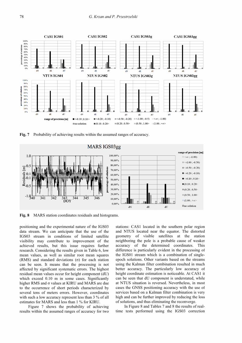
Fig. 7 Probability of achieving results within the assumed ranges of accuracy.
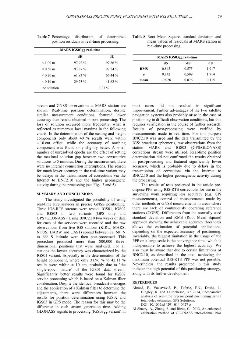
Fig. 8 MARS station coordinates residuals and histograms.
stations: CAS1 located in the southern polar regionand NTUS located near the equator. The distortedgeometry of visible satellites at the stationneighboring the pole is a probable cause of weakeraccuracy of the determined coordinates. Thisdifference is particularly evident in the processing ofthe IGS01 stream which is a combination of single-epoch solutions. Other variants based on the streamsusing the Kalman filter combination resulted in muchbetter accuracy. The particularly low accuracy ofheight coordinate estimation is noticeable. At CAS1 itcan be seen that dU component is understated, whileat NTUS situation is reversed. Nevertheless, in mostcases the GNSS positioning accuracy with the use ofservices based on a Kalman filter combination is veryhigh and can be further improved by reducing the lossof solutions, and thus eliminating the reconverge.
In Figure 8 and Tables 7 and 8 the results of real-time tests performed using the IGS03 correction
positioning and the experimental nature of the IGS03data stream. We can anticipate that the use of theIGS03 stream in conditions of limited satellitevisibility may contribute to improvement of theachieved results, but this issue requires furtherresearch. Considering the results given in Table 6, lowmean values, as well as similar root mean squares(RMS) and standard deviations (σ) for each stationcan be seen. It means that the processing is notaffected by significant systematic errors. The highestresidual mean values occur for height component (dU)which exceed 0.10 m in some cases. Significantlyhigher RMS and σ values at KIRU and MARS are dueto the occurrence of short periods characterized byseveral tens of meters errors. However, coordinateswith such a low accuracy represent less than 3 % of allestimates for MARS and less than 1 % for KIRU.
Figure 7 shows the probability of achievingresults within the assumed ranges of accuracy for two
GPS/GLONASS PRECISE POINT POSITIONING WITH IGS REAL-TIME … .
79
Table 8 Root Mean Square, standard deviation andmean values of residuals at MARS station inreal-time processing.
Table 7 Percentage distribution of determinedposition residuals in real-time processing.
MARS IGS03gg real-time
dN dE dU
RMS 0.843 0.575 1.917
σ 0.842 0.509 1.914
mean -0.026 0.076 0.115
MARS IGS03gg real-time
dH dU
< 1.00 m 97.92 % 97.86 %
< 0.50 m 93.87 % 92.24 %
< 0.20 m 61.83 % 66.44 %
< 0.10 m 29.73 % 41.62 %
no solution 1.23 %
most cases did not resulted in significantimprovement. Further advantages of the two satellitenavigation systems also probably arise in the case ofpositioning in difficult observation conditions, but thisrequires verification in the course of further research.Results of post-processing were verified bymeasurements made in real-time. For this purposeBNC2.10 was used and the data transmitted by theIGS: broadcast ephemeris, raw observations from thestation MARS and IGS03 (GPS/GLONASS)corrections stream were utilized. Real-time positiondetermination did not confirmed the results obtainedin post-processing and featured significantly loweraccuracy, which is probably due to delays in thetransmission of corrections via the Internet toBNC2.10 and the higher geomagnetic activity duringthe processing.
The results of tests presented in the article pre-dispose PPP using IGS-RTS corrections for use in thesurveying work requiring less accuracy (e.g. GISmeasurements), control of measurements made byother methods or GNSS measurements in areas wherethere are lack of continuously operating referencestations (CORS). Differences from the normally usedstandard deviation and RMS (Root Mean Square)approach showing the achievable accuracy thresholdsallows the estimation of potential applications,depending on the expected accuracy of positioning.Invariably, the biggest limitation in the usage of thePPP on a large scale is the convergence time, which isindispensable to achieve the highest accuracy. Wealso must be aware that due to certain limitations ofBNC2.10, as described in the text, achieving themaximum potential IGS-RTS PPP was not possible.Nevertheless, the results presented in this studyindicate the high potential of this positioning strategy,along with its further development.
REFERENCES
Ahmed, F., Václavović, P., Teferle, F.N., Douša, J.,Bingley, R. and Laurichesse, D.: 2014, Comparativeanalysis of real-time precise point positioning zenithtotal delay estimates. GPS Solutions. DOI: 10.1007/s10291-014-0427-z
Al-Shaery, A., Zhang, S. and Rizos, C.: 2013, An enhancedcalibration method of GLONASS inter-channel bias
stream and GNSS observations at MARS station areshown. Real-time position determination, despitesimilar measurement conditions, featured loweraccuracy than results obtained in post-processing. Theloss of solution occurred more frequently, what isreflected as numerous local maxima in the followingcharts. In the determination of the easting and heightcomponents only about 40 % results were within± 10 cm offset, while the accuracy of northingcomponent was found only slightly better. A smallnumber of unresolved epochs are the effect of settingthe maximal solution gap between two consecutivesolutions to 5 minutes. During the measurement, therewere no internet connection interruptions. The reasonfor much lower accuracy in the real-time variant maybe delays in the transmission of corrections via theInternet to BNC2.10 and the higher geomagneticactivity during the processing (see Figs. 3 and 5).
SUMMARY AND CONCLUSIONS
The study investigated the possibility of usingreal-time IGS services in precise GNSS positioning.Three IGS-RTS streams were tested: IGS01, IGS02and IGS03 in two variants (GPS only andGPS+GLONASS). Using BNC2.10 two weeks of datafor each of the services were recorded and the rawobservations from five IGS stations (KIRU, MARS,NTUS, DARW and CAS1) spread between ca. 68° Nto 66° S latitude were then post-processed. Thisprocedure produced more than 800,000 three-dimensional positions that were analyzed. For allstations the lowest accuracy was characterized by theIGS01 variant. Especially in the determination of theheight component, where only 31.96 % to 42.11 %results were within ± 10 cm, probably due to "thesingle-epoch nature" of the IGS01 data stream.Significantly better results were found for IGS02service processing which is based on a Kalman filtercombination. Despite the identical broadcast messagesand the application of a Kalman filter to determine theadjustments, there were differences between theresults for position determination using IGS02 andIGS03 in GPS mode. The reason for this may be thedifference in each stream generation time. AddingGLONASS signals to processing (IGS03gg variant) in
G. Krzan and P. Przestrzelski
80
Control Symposium. Joint with the 21st EuropeanFrequency and Time Forum, Geneva, 904 –908.
Douša, J. and Vaclavović, P.: 2014, Real-time zenithtropospheric delays in support of numerical weatherprediction applications. Adv Space Res., 53, No. 9,1347–1358. DOI: 10.1016/j.asr.2014.02.021
Elsobeiey M. and Al-Harbi S., 2015. Performance of real-time Precise Point Positioning using IGS real-timeservice. GPS Solutions. DOI: 10.1007/s10291-015-0467-z
Ge, M., Gendt, G., Rothacher, M., Shi, C. and Liu, J.: 2008,Resolution of GPS carrier-phase ambiguities inprecise point positioning (PPP) with dailyobservations. Journal of Geodesy, 8, No. 7, 389 –399.DOI: 10.1007/s00190-007-0187-4
Guo, F., Zhang, X.H. and Wang, J.: 2015, Timing groupdelay and differential code bias corrections forBeiDou positioning. Journal of Geodesy, 89, No. 5,427 –445. DOI: 10.1007/s00190-015-0788-2
Hadaś, T. and Bosy, J.: 2014, IGS RTS precise orbits andclocks verification and quality degradation over time.GPS Solutions, 19, No. 1, 93 –105. DOI:10.1007/s10291-014-0369-5
Jin, S., Park, J.U., Cho, J.H. and Park, P.H.: 2007, Seasonalvariability of GPS-derived zenith tropospheric delay(1994–2006) and climate implications. Journal ofGeophysical Research, 112(D9). DOI: 10.1029/2006JD007772
Juan, J.M., Hernandez-Pajares, M., Sanz, J., Ramos-Bosch,P., Aragon-Angel, A., Orus, R., Ochieng, W., Feng,S., Jofre, M., Coutinho, P. and Tossaint, M.: 2012,Enhanced Precise Point Positioning for GNSS users.IEEE Transactions on Geoscience and RemoteSensing, 50, No. 10, 4213–4222. DOI: 10.1109/TGRS.2012.2189888
Kalita, J., Rzepecka, Z. and Krzan, G., 2014. Evaluation ofthe possibility of using the predicted troposphericdelays in real time GNSS positioning. ArtificialSatellites, 49, No. 4, 179–189. DOI: 10.2478/arsa-2014-0014
Kim, H.S., Lee, J.Y., Choi, K.H., Heo, M.B. and Lee, H.K.:2013, Receiver inter-channel bias search techniquebased on LAMBDA. Proceedings of IGNSSSymposium, Gold Coast, July 16-18 2013.
Kouba, J.: 2002, Sub-daily Earth rotation parameters and theInternational GPS Service Orbit/Clock Solutionproducts. Studia Geophysica et Geodetica, 46, No. 1, 9–25. DOI: 10.1023/A:1019894614643
Kouba, J.: 2009, A Guide to using International GNSSService (IGS) Products. Geodetic Survey Division.Natural Resources Canada. (online at:http://igscb.jpl.nasa.gov/igscb/resource/pubs/UsingIGSProductsVer21.pdf)
Laurichesse, D.: 2011, The CNES Real-time PPP withundifferenced integer ambiguity resolutiondemonstrator. 11. Proceedings of the ION GNSS2011, Portland. Oregon, 654–662.
Leandro, R.F., Santos, M.C. and Langley, R.B.: 2011,Analyzing GNSS data in precise point positioningsoftware. GPS Solutions, 15, No. 1, 1 –13. DOI: 10.1007/s10291-010-0173-9
Leick, A.: 2004, GPS Satellite surveying. JohnWiley&Sons. New Jersey.
Li, P. and Zhang, X.: 2014, Integrating GPS and GLONASSto accelerate convergence and initialization times ofprecise point positioning. GPS Solutions, 18, No. 3,461–471. DOI: 10.1007/s10291-013-0345-5
for GNSS RTK. GPS Solutions, 17, No. 2, 165 –173.DOI: 10.1007/s10291-012-0269-5
Bakuła, M.: 2013, Study of reliable rapid and ultrarapidstatic GNSS surveying for determination of thecoordinates of control points in obstructed conditions.Journal of Surveying Engineering, 139, No. 4, 188 –193. DOI: 10.1061/(ASCE)SU.1943-5428.0000109
Bakuła, M., Przestrzelski, P. and Kaźmierczak, R.: 2015,Reliable technology of centimeter GPS/GLONASSsurveying in forest environments. IEEE Transactionson Geoscience and Remote Sensing, 53, No. 2, 1029 –1038. DOI: 10.1109/TGRS.2014.2332372
Bartels, J.: 1957, The technique of scaling indices K and Qof geomagnetic activity. Ann Intern Geophys., l, 4,215–226.
Baryła, R., Paziewski, J., Wielgosz, P., Stępniak, K. andKrukowska, M.: 2014, Accuracy assessment of theground deformation monitoring with the use of GPSlocal network: Open pit mine Koźmin Case Study.Acta Geodyn. Geomater., 11, No. 4, 317-324. DOI: 10.13168/AGG.2014.0013
Boehm, J., Heinkelmann, R. and Schuh, H.: 2007, Shortnote: a global model of pressure and temperature forgeodetic applications. Journal of Geodesy, 81, No. 10,679 –683. DOI: 10.1007/s00190-007-0135-3
Cai, Ch. and Gao, Y.: 2007, Precise Point Positioning usingcombined GPS and GLONASS observations. Journalof Global Positioning System., 6, No. 1, 13 –22.
Cai, Ch. and Gao, Y.: 2013, GLONASS-based precise pointpositioning and performance analysis. Advances inSpace Research., 51, No. 3, 514-524. DOI: 10.1016/j.asr.2012.08.004
Chen J., Ge M., Douša J. and Gendt, G., 2009. Evaluation ofEPOS-RT for real-time deformation monitoring.Journal of Global Positioning Systems, 8, No. 1, 1 –5.
Chen, J., Xiao, P., Zhang, Y. and Wu, B.: 2013a,GPS/GLONASS system bias estimation andapplication in GPS/GLONASS combined positioning.China Satellite Navigation Conference (CSNC) 2013Proceedings. Lecture Notes in Electrical Engineering,244, 323 –333. DOI: 10.1007/978-3-642-37404-3_29
Chen, J., Li, H., Wu, B., Zhang Y., Wang, J. and Hu, C.:2013b, Performance of real-time precise pointpositioning. Marine Geodesy, 36, No. 1, 98 –108.DOI: 10.1080/01490419.2012.699503
Chuang, S., Wenting, Y., Weiwei, S., Yidong, L., Yibin, Y.and Rui, A.: 2013, GLONASS pseudorange inter-channel biases and their effects on combinedGPS/GLONASS precise point positioning. GPSSolutions, 17, No. 4, 439–451. DOI: 10.1007/s10291-013-0332-x
Collins, P.: 2008, Isolating and estimating undifferencedGPS integer ambiguities. Proceedings of ION nationaltechnical meeting. San Diego, US, 720–732.
Davis, J. L., Herring, T. A., Shapiro, I. I., Rogers, A.E.E.and Elgered, G.: 1985, Geodesy by radio inter-ferometry: effects of atmospheric modelling errors onestimates of baseline length. Radio Science, 20, No. 6,1593–1607. DOI: 10.1029/RS020i006p01593
Dawidowicz, K. and Krzan, G.: 2014, Coordinate estimationaccuracy of static precise point positioning using on-line PPP service- a case study. Acta Geodaetica etGeophysica Hungarica, 49, No. 1, 37–55. DOI: 10.1007/s40328-013-0038-0
Defraigne, P., Bruyninx, C. and Guyennon, N.: 2007, PPPand phase-only GPS time and frequency transfer.Proceedings of the IEEE International Frequency
GPS/GLONASS PRECISE POINT POSITIONING WITH IGS REAL-TIME … .
81
Van Bree, R. J. P. and Tiberius, Ch. C. J. M.: 2012, Real-time single-frequency precise point positioning:accuracy assessment. GPS Solutions, 16, No. 2, 259–266. DOI: 10.1007/s10291-011-0228-6
Van Der Marel, H. and De Bakker, P.: 2012, Single versusDual-Frequency Precise Point Positioning. What arethe tradeoffs between using L1-only and L1+l2 forPPP? Inside GNSS, 7, No. 4, 30–35.
Van Dam, T.M., Blewitt, G. and Heflin, M.B.: 1994,Atmospheric pressure loading effects on GlobalPositioning System coordinate determinations.Journal of Geophysical Research, 99, B12, 23939–23950. DOI: 10.1029/94JB02122
Wang, J., Knight, N.L. and Lu, X.: 2011, Impact of theGNSS time offsets on positioning reliability. Journalof Global Positioning System, 10, No. 2, 165–172.DOI: 10.5081/jgps.10.2.165
Wanninger, L.: 2012, Carrier-phase inter-frequency biasesof GLONASS receivers. Journal of Geodesy, 86, No.2, 139–148. DOI: 10.1007/s00190-011-0502-y
Wanninger, L. and Wallstab-Freitag, S.: 2007, Combinedprocessing of GPS, GLONASS and SBAS code phaseand carrier phase measurements. Proceedings of IONGNSS 2007, Fort Worth, Tx., 866–875.
Wielgosz, P., Krukowska, M., Paziewski, J., Krypiak-Gregorczyk, A., Stępniak, K., Kapłon, J., Sierny, J.,Hadaś, T. and Bosy, J.: 2013, Performance of ZTDmodels derived in near real-time from GBAS andmeteorological data in GPS fast-static positioning.Measurement Science and Technology, 24, No. 12 DOI:10.1088/0957-0233/24/12/125802.
Yamada, H., Takasu, T., Kubo, N. and Yasuda, A.: 2010,Evaluation and calibration of receiver inter-channelbiases for RTK-GPS/GLONASS. Proceedings of 23rdInternational Technical Meeting of the SatelliteDivision of the Institute of Navigation, Portland,1580–1587.
Zumberge, J.F., Heflin, M.B., Jefferson, D.C., Watkins,M.M. and Webb, F.H.: 1997, Precise Point Positioningfor the efficient and robust analysis of GPS data fromlarge networks. Journal of Geophysic Research, 102,B3, 5005–5017. DOI: 10.1029/96JB03860
Li, X., Ge, M., Dai, X., Ren, X., Fritsche, M., Wickert, J.and Schuh, H.: 2015, Accuracy and reliability ofmulti-GNSS real-time precise positioning: GPS,GLONASS, BeiDou, and Galileo. Journal of Geodesy,89, No. 6, 607–635. DOI: 10.1007/s00190-015-0802-8
Li, X., Ge, M., Lu, C., Zhang, Y., Wang, R., Wickert, J. andSchuh, H.: 2014, High-rate GPS seismology usingreal-time precise point positioning with ambiguityresolution. IEEE Transactions on Geoscience andRemote Sensing, 52, No. 10, 6165–6180. DOI:10.1109/TGRS.2013.2295373
Li, X., Ge, M., Zhang, H., Nischan, T. and Wickert J.: 2013,The GFZ real-time GNSS precise positioning servicesystem and its adaption for COMPASS. Advances inSpace Research, 51, No. 6, 1008–1018. DOI: 10.1016/j.asr.2012.06.025
Misra, P. and Enge, P.: 2011, Global Positioning System:Signals. Measurements. and Performance. RevisedSecond Edition. Ganga-Jamuna Press. Lincoln,Massachusetts.
Montenbruck, O. and Hauschild, A.: 2014, Differential codebias estimation using Multi-GNSS observations andGlobal Ionosphere Maps. Proceedings of the ION-ITM 2014, San Diego, 802–812.
Reussner, N. and Wanninger, L.: 2011, GLONASS inter-frequency biases and their effects on RTK and PPPcarrier-phase ambiguity resolution. Proceedings of theION GNSS 2011, Portland, Oregon, 712 –716.
Saastamoinen, J.: 1972, Atmospheric correction fortroposphere and stratosphere in radio ranging ofsatellites. The Use of Artificial Satellites for Geodesy.Geophysical Monograph, 15, 247–252. DOI: 10.1029/GM015p0247
Salazar, D., Hernandez-Pajares, M., Juan, J. M. and Sanz, J.:2010, GNSS data management and processing withthe GPSTk. GPS Solutions, 14, No. 3, 293–299. DOI: 10.1007/s10291-009-0149-9
Shi, Ch., Yi, W., Song, W., Lou, Y., Yao, Y. and Zhang, R.:2013, GLONASS pseudorange inter-channel biasesand their effects on combined GPS/GLONASS precisepoint positioning. GPS Solutions, 17, No. 4, 439–451.DOI: 10.1007/s10291-013-0332-x
Shi, J., Xu, C., Li, Y. and Gao, Y.: 2015, Impacts of real-time satellite clock errors on GPS precise pointpositioning-based troposphere zenith delay estimation.Journal of Geodesy. DOI: 10.1007/s00190-015-0811-7
Torre, A.D. and Caporali, A.: 2014, An analysis ofintersystem biases for multi-GNSS positioning. GPSSolutions, 19, No. 2, 297–307. DOI: 10.1007/s10291-014-0388-2