100°48'10W 100°48'8W 100°48'6W 100°48'4W 100°48'2W · PDF file!l...
1
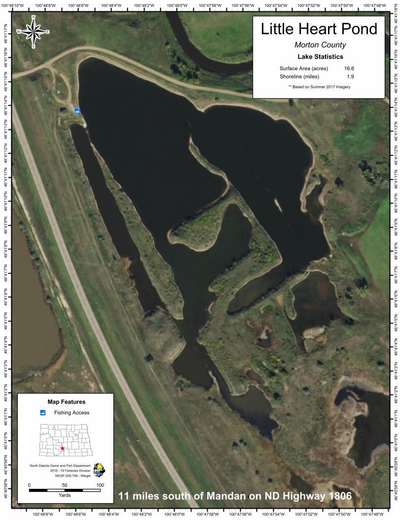
! l 100°47'48"W 100°47'48"W 100°47'50"W 100°47'50"W 100°47'52"W 100°47'52"W 100°47'54"W 100°47'54"W 100°47'56"W 100°47'56"W 100°47'58"W 100°47'58"W 100°48'0"W 100°48'0"W 100°48'2"W 100°48'2"W 100°48'4"W 100°48'4"W 100°48'6"W 100°48'6"W 100°48'8"W 100°48'8"W 100°48'10"W 46°41'18"N 46°41'17"N 46°41'17"N 46°41'16"N 46°41'16"N 46°41'15"N 46°41'15"N 46°41'14"N 46°41'14"N 46°41'13"N 46°41'13"N 46°41'12"N 46°41'12"N 46°41'11"N 46°41'11"N 46°41'10"N 46°41'10"N 46°41'9"N 46°41'9"N 46°41'8"N 46°41'8"N 46°41'7"N 46°41'7"N 46°41'6"N 46°41'6"N 46°41'5"N 46°41'5"N 46°41'4"N 46°41'4"N 46°41'3"N 46°41'3"N 46°41'2"N 46°41'2"N 46°41'1"N 46°41'1"N 46°41'0"N 46°41'0"N 46°40'59"N 46°40'59"N 46°40'58"N 46°40'58"N 2018 - 19 Fisheries Division North Dakota Game and Fish Department 11 miles south of Mandan on ND Highway 1806 ® ^ 0 100 50 Yards Map Features NDGF-GIS-746 - Weigel Morton County Little Heart Pond Shoreline (miles) 1.9 Lake Statistics Surface Area (acres) 16.6 ** Based on Summer 2017 Imagery Fishing Access ! l
Transcript of 100°48'10W 100°48'8W 100°48'6W 100°48'4W 100°48'2W · PDF file!l...
!l
100°47'48"W
100°47'48"W
100°47'50"W
100°47'50"W
100°47'52"W
100°47'52"W
100°47'54"W
100°47'54"W
100°47'56"W
100°47'56"W
100°47'58"W
100°47'58"W
100°48'0"W
100°48'0"W
100°48'2"W
100°48'2"W
100°48'4"W
100°48'4"W
100°48'6"W
100°48'6"W
100°48'8"W
100°48'8"W100°48'10"W
46°41
'18"N
46°41
'17"N
46°41
'17"N
46°41
'16"N
46°41
'16"N
46°41
'15"N
46°41
'15"N
46°41
'14"N
46°41
'14"N
46°41
'13"N
46°41
'13"N
46°41
'12"N
46°41
'12"N
46°41
'11"N
46°41
'11"N
46°41
'10"N
46°41
'10"N
46°41
'9"N
46°41
'9"N
46°41
'8"N
46°41
'8"N
46°41
'7"N
46°41
'7"N
46°41
'6"N
46°41
'6"N
46°41
'5"N
46°41
'5"N
46°41
'4"N
46°41
'4"N
46°41
'3"N
46°41
'3"N
46°41
'2"N
46°41
'2"N
46°41
'1"N
46°41
'1"N
46°41
'0"N
46°41
'0"N
46°40
'59"N
46°40
'59"N
46°40
'58"N
46°40
'58"N
2018 - 19 Fisheries DivisionNorth Dakota Game and Fish Department
11 miles south of Mandan on ND Highway 1806
®
^
0 10050Yards
Map Features
NDGF-GIS-746 - Weigel
Morton CountyLittle Heart Pond
Shoreline (miles) 1.9
Lake StatisticsSurface Area (acres) 16.6
** Based on Summer 2017 Imagery
Fishing Access!l


![0)1'#$ · PDF file7ye frgf(v(j./4(]"&.l(w+..&(e.,-&"#"'6(7)+3()&:(g&.+'6(!)+1(=(%&,#@:%&'($"":(')/%f,)?"&()&:()&).+">%,(:%'./4.+(*#)](https://static.fdocuments.pl/doc/165x107/5a78f6017f8b9a217b8b4e6b/01-frgfvj4lwe-673g61f4.jpg)