
Using QGIS for FTTH/GPON network planning due to … · The building structure (SDU, MDU) and the...
8
Softelnet spółka akcyjna sp.k. Sąd Rejestrowy: Sąd Rejonowy dla Krakowa-Śródmieścia w Krakowie, XI Wydział Gospodarczy Krajowego Rejestru Sądowego, KRS: 0000274071, NIP: 677-22-84-294, REGON: 120410570 Using QGIS for FTTH/GPON network planning due to the implementation European Digital Agenda
-
Upload
nguyenminh -
Category
Documents
-
view
220 -
download
0
Transcript of Using QGIS for FTTH/GPON network planning due to … · The building structure (SDU, MDU) and the...
Softelnet spółka akcyjna sp.k.
Sąd Rejestrowy: Sąd Rejonowy dla Krakowa-Śródmieścia w Krakowie, XI Wydział Gospodarczy Krajowego Rejestru Sądowego, KRS: 0000274071, NIP: 677-22-84-294, REGON: 120410570
Using QGIS for FTTH/GPON
network planning due to the
implementation
European Digital Agenda
Softelnet spółka akcyjna sp.k.
Sąd Rejestrowy: Sąd Rejonowy dla Krakowa-Śródmieścia w Krakowie, XI Wydział Gospodarczy Krajowego Rejestru Sądowego, KRS: 0000274071, NIP: 677-22-84-294, REGON: 120410570
Definition of the problem
Over the past few years many EU countries have launched operational programs to
implement European Digital Agenda (EAC) developed by the European Commission in 2010.
According to its guidelines until 2020 every citizen of the European Union should have access to 30
Mbps Internet bandwidth and at least half of the them will have access to bandwidth not slower than
100 Mbps.
Poland is one of the countries in which the Agenda is being implemented. Polish program
called POPC, which is currently in force, assumes building of NGA networks in areas where
independent investments of telecoms entrepreneurs would not occur without public support.
Thanks to European Union funds many local operators can compete with large telecom
providers as regards high-speed broadband services. Unfortunately, applying for funding requires a
great deal of work necessary to draw up proper documentation, including, among other things,
development of planned FTTx optical fibre network conceptual maps.
Moreover, currently there are no GIS-based IT tools available to support the potential
beneficiaries with the preparation of documentation. The complexity of the problem is even more
complicated by the fact that such a software should enable a creation of documentation in
accordance with specific program guidelines (e.g. the obligation to connect educational institutions).
Description of the solution
As we have worked in the telecommunications industry for many years and have extensive
experience as regards GIS software, we have undertaken the task of developing software supporting
the development of technical map of FTTH concept network and preparation of data aimed at
creating detailed cost estimate of the investment. A number of products generated by the software
is to allow the entities applying for EU funds to significantly speed up the application preparation
process.
We have selected QGIS as a geospatial platform to serve as a basis for our solution. Due to
the high popularity, widespread availability, openness of the software and immense functional
abilities, it felt natural to select QGIS.
According to the guidelines of FTTH Council Europe, it is crucial to first prepare a plan considering
both the technical aspect (placement of cables, splice closures, splitters) and economic aspect
(demand) based on real address points data. The building structure (SDU, MDU) and the density of
the building development (distributed, dense) determine the technology of GPON optical fiber
network design. The ability to plan network topology, use the suitable infrastructure, selecting fiber
cable profiles and suitable allocation of splice closures and splitters require among other things:
• access to GIS data,
• automation of GIS data processing,
Softelnet spółka akcyjna sp.k.
Sąd Rejestrowy: Sąd Rejonowy dla Krakowa-Śródmieścia w Krakowie, XI Wydział Gospodarczy Krajowego Rejestru Sądowego, KRS: 0000274071, NIP: 677-22-84-294, REGON: 120410570
• application of network optimization algorithms,
• application of GPON network engineering rules for optimal device selection and their
placement.
All these items were connected to obtain one solution which we developed using QGIS platform
and made it available on our website. Below there is a brief description of how we prepared for the
realization of the project and what functional items were incorporated to create one solution.
In order to achieve our goal, we needed few functional components apart from the already
existing GIS platform:
• GRASS - a collection of vector and network algorithms
• QGIS plugins - OpenLayer, QuickOSM, Scipy Point Clustering, WorkContextTracer (our plug-
in)
• QGIS modeler – tool for graphical flow modelling
• SpatiaLite - a local database for storing input and output data
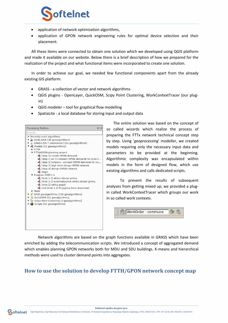
The entire solution was based on the concept of
so called wizards which realize the process of
preparing the FTTx network technical concept step
by step. Using 'geoprocessing' modeller, we created
models requiring only the necessary input data and
parameters to be provided at the beginning.
Algorithmic complexity was encapsulated within
models in the form of designed flow, which use
existing algorithms and calls dedicated scripts.
To prevent the results of subsequent
analyses from getting mixed up, we provided a plug-
in called WorkContextTracer which groups our work
in so called work contexts.
Network algorithms are based on the graph functions available in GRASS which have been
enriched by adding the telecommunication scripts. We introduced a concept of aggregated demand
which enables planning GPON networks both for MDU and SDU buildings. K-means and hierarchical
methods were used to cluster demand points into aggregates.
How to use the solution to develop FTTH/GPON network concept map
Softelnet spółka akcyjna sp.k.
Sąd Rejestrowy: Sąd Rejonowy dla Krakowa-Śródmieścia w Krakowie, XI Wydział Gospodarczy Krajowego Rejestru Sądowego, KRS: 0000274071, NIP: 677-22-84-294, REGON: 120410570
Users received a tool which, on the one hand, is using standard QGIS interface and, on the
other hand, enables achieving satisfactory results in very little time. If the user is skilled, the
development of the optical fiber network plan takes no more than 15 minutes.
The user starts work by
opening a new work context
and specifying an input layer of
address points to be analysed.
Using the standard QGIS
interface, the user can manage
demand on address points and
finally provide the parameters
necessary for further steps of
the algorithm.
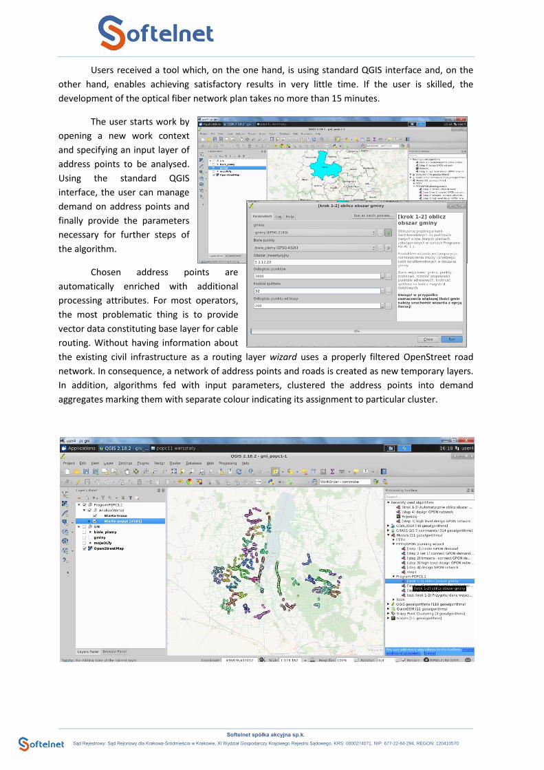
Chosen address points are
automatically enriched with additional
processing attributes. For most operators,
the most problematic thing is to provide
vector data constituting base layer for cable
routing. Without having information about
the existing civil infrastructure as a routing layer wizard uses a properly filtered OpenStreet road
network. In consequence, a network of address points and roads is created as new temporary layers.
In addition, algorithms fed with input parameters, clustered the address points into demand
aggregates marking them with separate colour indicating its assignment to particular cluster.
Softelnet spółka akcyjna sp.k.
Sąd Rejestrowy: Sąd Rejonowy dla Krakowa-Śródmieścia w Krakowie, XI Wydział Gospodarczy Krajowego Rejestru Sądowego, KRS: 0000274071, NIP: 677-22-84-294, REGON: 120410570
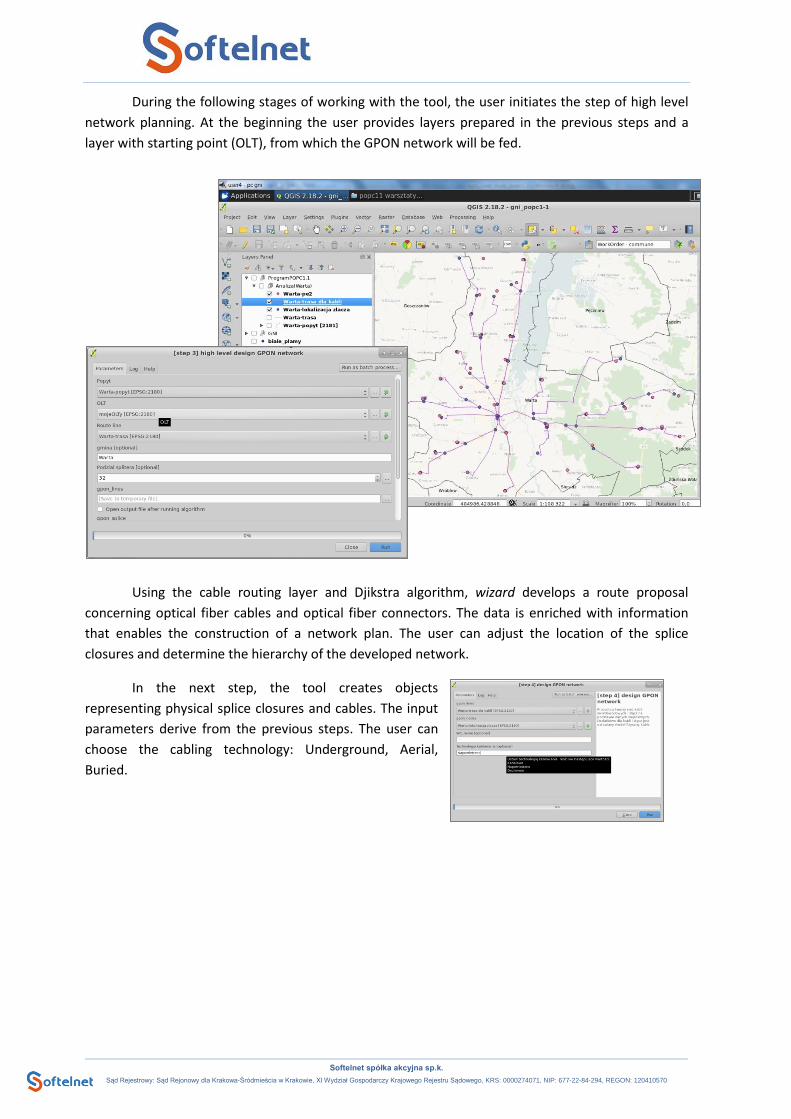
During the following stages of working with the tool, the user initiates the step of high level
network planning. At the beginning the user provides layers prepared in the previous steps and a
layer with starting point (OLT), from which the GPON network will be fed.
Using the cable routing layer and Djikstra algorithm, wizard develops a route proposal
concerning optical fiber cables and optical fiber connectors. The data is enriched with information
that enables the construction of a network plan. The user can adjust the location of the splice
closures and determine the hierarchy of the developed network.
In the next step, the tool creates objects
representing physical splice closures and cables. The input
parameters derive from the previous steps. The user can
choose the cabling technology: Underground, Aerial,
Buried.
Softelnet spółka akcyjna sp.k.
Sąd Rejestrowy: Sąd Rejonowy dla Krakowa-Śródmieścia w Krakowie, XI Wydział Gospodarczy Krajowego Rejestru Sądowego, KRS: 0000274071, NIP: 677-22-84-294, REGON: 120410570
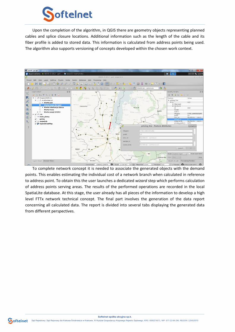
Upon the completion of the algorithm, in QGIS there are geometry objects representing planned
cables and splice closure locations. Additional information such as the length of the cable and its
fiber profile is added to stored data. This information is calculated from address points being used.
The algorithm also supports versioning of concepts developed within the chosen work context.
To complete network concept it is needed to associate the generated objects with the demand
points. This enables estimating the individual cost of a network branch when calculated in reference
to address point. To obtain this the user launches a dedicated wizard step which performs calculation
of address points serving areas. The results of the performed operations are recorded in the local
SpatiaLite database. At this stage, the user already has all pieces of the information to develop a high
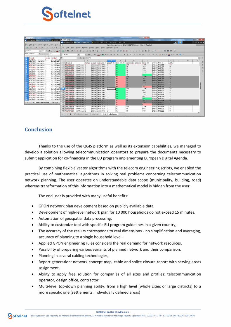
level FTTx network technical concept. The final part involves the generation of the data report
concerning all calculated data. The report is divided into several tabs displaying the generated data
from different perspectives.
Softelnet spółka akcyjna sp.k.
Sąd Rejestrowy: Sąd Rejonowy dla Krakowa-Śródmieścia w Krakowie, XI Wydział Gospodarczy Krajowego Rejestru Sądowego, KRS: 0000274071, NIP: 677-22-84-294, REGON: 120410570
Conclusion
Thanks to the use of the QGIS platform as well as its extension capabilities, we managed to
develop a solution allowing telecommunication operators to prepare the documents necessary to
submit application for co-financing in the EU program implementing European Digital Agenda.
By combining flexible vector algorithms with the telecom engineering scripts, we enabled the
practical use of mathematical algorithms in solving real problems concerning telecommunication
network planning. The user operates on understandable data scope (municipality, building, road)
whereas transformation of this information into a mathematical model is hidden from the user.
The end user is provided with many useful benefits:
• GPON network plan development based on publicly available data,
• Development of high-level network plan for 10 000 households do not exceed 15 minutes,
• Automation of geospatial data processing,
• Ability to customize tool with specific EU program guidelines in a given country,
• The accuracy of the results corresponds to real dimensions - no simplification and averaging,
accuracy of planning to a single household level.
• Applied GPON engineering rules considers the real demand for network resources,
• Possibility of preparing various variants of planned network and their comparison,
• Planning in several cabling technologies,
• Report generation: network concept map, cable and splice closure report with serving areas
assignment,
• Ability to apply free solution for companies of all sizes and profiles: telecommunication
operator, design office, contractor,
• Multi-level top-down planning ability: from a high level (whole cities or large districts) to a
more specific one (settlements, individually defined areas)

Softelnet spółka akcyjna sp.k.
Sąd Rejestrowy: Sąd Rejonowy dla Krakowa-Śródmieścia w Krakowie, XI Wydział Gospodarczy Krajowego Rejestru Sądowego, KRS: 0000274071, NIP: 677-22-84-294, REGON: 120410570
The user has the possibility to use the generated data to:
• precisely determine the construction and depreciation costs of the network,
• calculate the cost of connecting each address point,
• prioritize address points from the most profitable to unprofitable,
• evaluate basic economic indicators like ROI, NPV
Useful links and bibliography • http://europa.eu/rapid/press-release_MEMO-10-200_en.htm - information on European
Digital Agenda
• http://www.ftthcouncil.eu/ - FTTH Council Europe website
• https://www.scipy.org/ - SciPy project website
• https://ksavinetworkinventory.com/en/ftthgpon-network-planning/ - the above described
tool webpage.
Authors
The solution is a free version of Geospatial Network Inventory. This system is part of a larger
project based on QGIS and FreeCAD platforms with its intention to be used in telecommunications
industry.
The author of the GNI FREE is Softelnet (https://www.softelnet.com,
https://ksavinetworkinventory.com), a company manufacturing and integrating software for the
telecommunications industry for over 15 years.