LAND USE CHANGES IN THE MAŁA WISŁA VALLEY...
16
PRACE KOMISJI KRAJOBRAZU KULTUROWEGO DISSERTATIONS OF CULTURAL LANDSCAPE COMMISSION NR 35/2017: 101-115 101 Jakub CZAJA, Oimahmad RAHMONOV Uniwersytet Śląski Wydział Nauk o Ziemi Sosnowiec, Polska e-mail: [email protected], [email protected] LAND USE CHANGES IN THE MAŁA WISŁA VALLEY IN THE WESTERN PART OF THE OŚWIĘCIM BASIN FROM THE 18 TH TO MODERN TIME ZMIANY ZAGOSPODAROWANIA DOLINY MAŁEJ WISŁY W ZACHODNIEJ CZĘŚCI KOTLINY OŚWIĘCIMSKIEJ OD XVIII W. DO CZASÓW WSPÓŁCZESNYCH Keywords: cartographical sources, historical maps, land use, land cover changes, Mała Wisła Słowa kluczowe: źródła kartograficzne, mapy historyczne, użytkowanie ziemi, zmiany pokrycia terenu, Mała Wisła Abstract The aim of this study is to reconstruct land use on the floodplain of the changes in the valley was based on archival materials, such as the plan of the Wisła valley from the mid-18th c., and the Prus-sian and Austrian topographical maps from the 1860s. As the analysis of land use changes in the floodplain of the Mała Wisła valley indicates, in the years 1754-1860 the biggest change referred to the area of forests and shelterbelts, because in a hundred years it decreased three times, i.e. from 3.18 km 2 to 1.05 km 2 . Other big changes include a diminished number and area of fish ponds, as well as smaller surface of the hydrogra- phic network. The layout and area of low density dwellings remained almost unchanged, as a reported increase in the surface area of this form of land use was only by about 0.4%. Significant changes in the surface of ponds and water reservoirs took place in the 1950s, when a dam reservoir was built in Goczał- kowice. Its caused an increase the ponds and reservoirs surface to 23.45 km 2 , which is over 64.7% of the grounds. Streszczenie Celem niniejszej pracy jest rekonstrukcja zagospodarowania zalewowej strefy doliny Małej Wisły od XVIII w. do czasów współczesnych. Analizę zmian zagospodaraowania doliny przeprowadzono na podstawie materiałów archi- walnych, jak plan doliny Wisły z połowy XVIII w. oraz pruskie i austriackie mapy topograficzne z lat 60. XIX w. Z analizy zmian zagospodarowania zalewowej strefy doliny Małej Wisły, w latach 1754-1860, wynika że: najwięk- szym zmianom uległa powierzchnia lasów i zadrzewień, bowiem w ciągu 100 lat trzykrotnie się zmniejszyła z 3,18 km2 do 1,05 km2, dużym zmianom uległa również liczba i powierzchnia stawów hodowlanych oraz powierzchniowa sieć hydrograficzna. Znaczące zmiany powierzchni stawów i zbiorników wodnych nastąpiły w latach 50. XX w., kiedy wybudowano w Goczałkowicach. Jego budowa spowodowała wzrost powierzchni stawów i zbiorników wod- nych do 23,45 km 2 co stanowi ponad 64,7 % użytków w obrębie analizowanej doliny.
Transcript of LAND USE CHANGES IN THE MAŁA WISŁA VALLEY...
PRACE KOMISJI KRAJOBRAZU KULTUROWEGO DISSERTATIONS OF CULTURAL LANDSCAPE COMMISSION
NR 35/2017: 101-115
101
Jakub CZAJA, Oimahmad RAHMONOV
Uniwersytet Śląski Wydział Nauk o Ziemi Sosnowiec, Polska e-mail: [email protected], [email protected]
LAND USE CHANGES IN THE MAŁA WISŁA VALLEY IN THE WESTERN PART OF THE OŚWIĘCIM BASIN FROM
THE 18TH TO MODERN TIME
ZMIANY ZAGOSPODAROWANIA DOLINY MAŁEJ WISŁY W ZACHODNIEJ CZĘŚCI KOTLINY OŚWIĘCIMSKIEJ
OD XVIII W. DO CZASÓW WSPÓŁCZESNYCH Keywords: cartographical sources, historical maps, land use, land cover changes, Mała Wisła Słowa kluczowe: źródła kartograficzne, mapy historyczne, użytkowanie ziemi, zmiany pokrycia terenu, Mała Wisła Abstract The aim of this study is to reconstruct land use on the floodplain of the changes in the valley was based on archival materials, such as the plan of the Wisła valley from the mid-18th c., and the Prus-sian and Austrian topographical maps from the 1860s. As the analysis of land use changes in the floodplain of the Mała Wisła valley indicates, in the years 1754-1860 the biggest change referred to the area of forests and shelterbelts, because in a hundred years it decreased three times, i.e. from 3.18 km2 to 1.05 km2. Other big changes include a diminished number and area of fish ponds, as well as smaller surface of the hydrogra-phic network. The layout and area of low density dwellings remained almost unchanged, as a reported increase in the surface area of this form of land use was only by about 0.4%. Significant changes in the surface of ponds and water reservoirs took place in the 1950s, when a dam reservoir was built in Goczał-kowice. Its caused an increase the ponds and reservoirs surface to 23.45 km2, which is over 64.7% of the grounds. Streszczenie Celem niniejszej pracy jest rekonstrukcja zagospodarowania zalewowej strefy doliny Małej Wisły od XVIII w. do czasów współczesnych. Analizę zmian zagospodaraowania doliny przeprowadzono na podstawie materiałów archi-walnych, jak plan doliny Wisły z połowy XVIII w. oraz pruskie i austriackie mapy topograficzne z lat 60. XIX w. Z analizy zmian zagospodarowania zalewowej strefy doliny Małej Wisły, w latach 1754-1860, wynika że: najwięk-szym zmianom uległa powierzchnia lasów i zadrzewień, bowiem w ciągu 100 lat trzykrotnie się zmniejszyła z 3,18 km2 do 1,05 km2, dużym zmianom uległa również liczba i powierzchnia stawów hodowlanych oraz powierzchniowa sieć hydrograficzna. Znaczące zmiany powierzchni stawów i zbiorników wodnych nastąpiły w latach 50. XX w., kiedy wybudowano w Goczałkowicach. Jego budowa spowodowała wzrost powierzchni stawów i zbiorników wod-nych do 23,45 km 2 co stanowi ponad 64,7 % użytków w obrębie analizowanej doliny.
102
INTRODUCTION
The analysis of historical changes in the geographical environment shows both the changes and their consequences that led to the creation of the modern-day spa-tial structures. The specificity of the analysis of changes in land use requires the use of various chronometric methods and the level of reconstruction of past environ-ments depends on the accuracy and reliability of the information contained in the archival records as well as sketches and maps (Nita, Myga-Piątek, 2012).
The study of the geographical environment should take into account both its spatial structure and – often not appreciated by many researchers – changes over time. Since the end of the Little Ice Age, i.e. for the past 250-300 years, nature has been transforming due to climate change, maturation and succession of geosystems as well as the build-up of intentional or unintentional interference of humans in the functioning of the environment. For this period of time there is a record of phenom-ena in the form of meteorological and hydrological measurements as well as detailed topographic images. At the same time, we need to remember that the intensity of the individual processes and changes in geosystems had never been so great and important as those over the mentioned time.
The query carried out by the authors enabled the "discovery" of unique plans, sketches, descriptions and topographic maps of the Wisła valley. The most valuable document is undoubtedly the plan of the Wisła river valley at a scale of approx. 1:4200 made under the supervision of J. H. Neüwertz in March 1754. The map includes the Wisła valley along a stretch of over 22 km from the village of Strumień to the mouth of the river Biała (Plan von der Situation ... 1754).
The aim of this study is to reconstruct the land use of the floodplain in the Mała Wisła valley in the 18th c. and to analyse the changes taking place in these areas for about a hundred years of human activity – to modern times. RESEARCH AREA AND SOURCE MATERIAL
The stretch of the valley selected for the research is situated in the western part
of the Oświęcim Basin between the village Strumień (Schwartzwasserischens) in the west and the mouth of the Biała in the east of the basin. It is about 22 km long, 0.6-2.0 km wide and about 36.28 km2 large. The boundaries of the Wisła valley floodplain are based on the Prussian topographic map from the late 19th c., which shows the limits of the maximum (historical) flood ranges in this part of the valley (Lageplan der Kleinen ... ca., 1895).
To achieve such a specific research aim archival materials were used, including in particular the plan of the Wisła river valley (Plan von der Situation ... 1754) from the mid-18th c., and the Prussian and Austrian topographical maps from the 1860s. These are Übersicht der Militar Mahren Aufnahme von und Schlesien, 1861-1863, at a scale of about 1:28 800, and General karte des Furstenhums Pless, 1863-1867, at a scale of 1:25 000, and contemporary topographic maps and the results of field
103
mapping from 2014 year (Czaja, 2015). Query archival made by Aleksandra Starczewska-Wojnar, Branch manager and archival materials AP Opole.
RESULTS AND DISCUSSION Historical maps as a source of information
In geographical studies the term "contemporary times" is often conventionally dated back to the times of the early 18th c., and thus covers the last three hundred years. This is because for this period of time there are many documents about the geographical environment of the Upper Wisła catchment as well as the type and size of anthropogenic changes. These materials relate primarily to the regulation of the river channel, construction of mills, levees, weirs, groynes, etc. The oldest of these documents date back to the early 18th c. These are all kinds of sketches, river cross-sections, first topographic maps and various types of expertise and scientific notes. In the first decades of the 19th c. the first, sporadic meteorological and hydro-logical measurements were carried out, widely used since the end of the 19th c. A valuable piece of work is an extensive monograph published in 1899 and entitled "Memel Pregel und Weischel ...", which – to our knowledge – has not been so far used in the geographical study of the Upper Wisła basin. The monograph has five volumes (about 1,000 pages of text) with extensive descriptions of historical floods, the results of the first meteorological and hydrological measurements, maps of reg-ulation projects in the river channel, cross-sections of the valley, and many others. Among the valuable archival materials we need to mention a few hundred regula-tory work plans: cutting off meanders, strengthening flood defences, construction of levees and changes of the Wisła riverbed, which are kept in the State Archives in Opole and Katowice. It should be noted that the Prussian and Austrian authori-ties conducted a large-scale cooperation and exchanged documents related to hydroengineering works in the Wisła valley.
Historical sources and archival materials have been so far poorly developed in terms of science information and as a result are rarely used by geographers. Few remember that the importance of these materials in the hydrometeorological studies was noticed more than a hundred years ago. In 1905, during the conference of Me-teorological Services in Innsbruck, members states of the International Meteorologi-cal Organization were recommended to search the archives and historical sources for information on meteorological and hydrological phenomena, such as freshets and floods, droughts, severe winters, severe storms, etc. Only in the interwar and post-war period several studies summarised the information about hydrological and meteorological phenomena in the Upper Wisła basin.
The most valuable studies include the three-volume "Chronicle of natural disas-ters in Galicia in the years 1772-1848" by J. Szewczuk (1939), "Climate and meteoro-logical phenomena in Silesia from the 16th to mid-19th c." by S. Inglot (1966), and "The 18th–20th c. flood-induced changes in the landscapes of the Mała Wisła valley within the Oświęcim Basin" by S. Czaja (2012). Among other interesting research
104
projects of this type, there is a collection of materials for the history of floods in the Upper Wisła basin developed by Associate Professor Józef Fiszer from the Cracow University of Technology (1997) based on the manuscripts of Kazimierz Bielański and Jan Fiszer.
Changes in land use
Land development, often understood as land use, can be seen as the result of a conscious, rational or not, human activities in the area. Human impact on the relief and land use contributed to the changes in the conditions of the outflow for-mation and therefore changes in the morphodynamic conditions of river channels. This is related to the colonisation of the Polish Carpathians. In the late 18th and early 19th c. compact settlement of the feudal type was reformed. As a result, a new systems of fields was developed and village built-up areas became less dense.
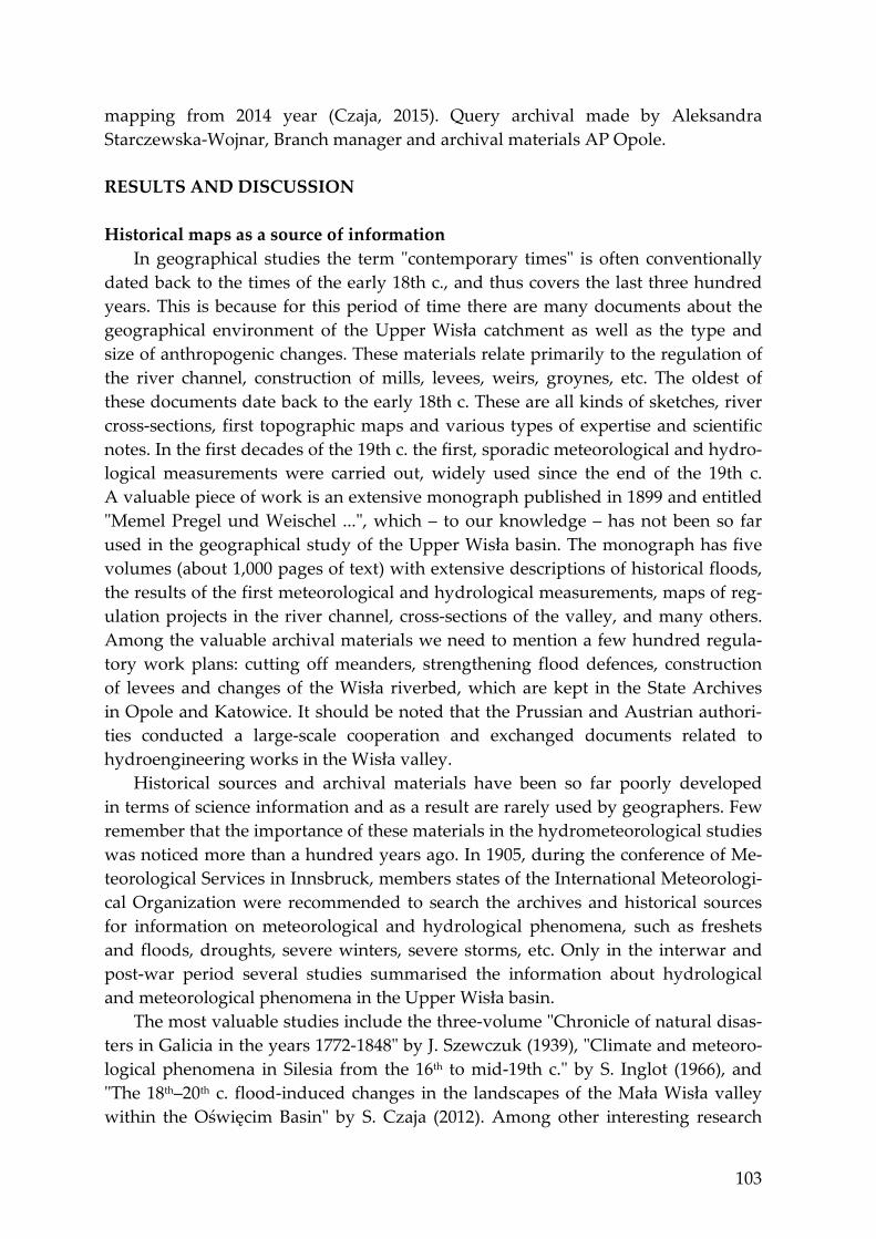
Changes due to intensive exploitation of forests and increased area of arable land, taking place in the 18th and 19th c., created favourable conditions for greater intensity of washing and erosion and – consequently – to aggradation of sediment in the Carpathian riverbeds. This process was accompanied by diminishing river depth and increasing width of riverbeds. An example of changes taking place until the mid-19th c. is the map of the Wisła valley in the vicinity of the mouth of the Przemsza (fig. 1). The catchment of the Mała Wisła to the mouth of the Biała is approx. 755 km2, and its tributaries drain the western part of the Western Carpathi-an Foothills and the southern part of the Silesian Upland.
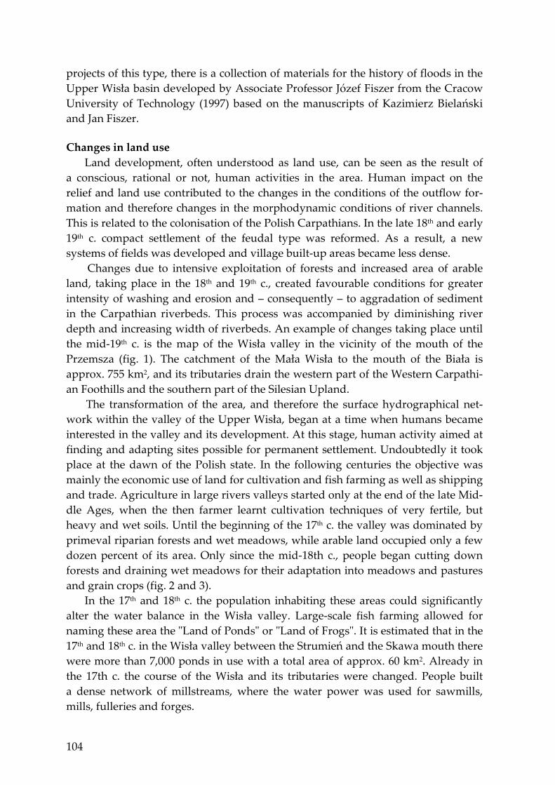
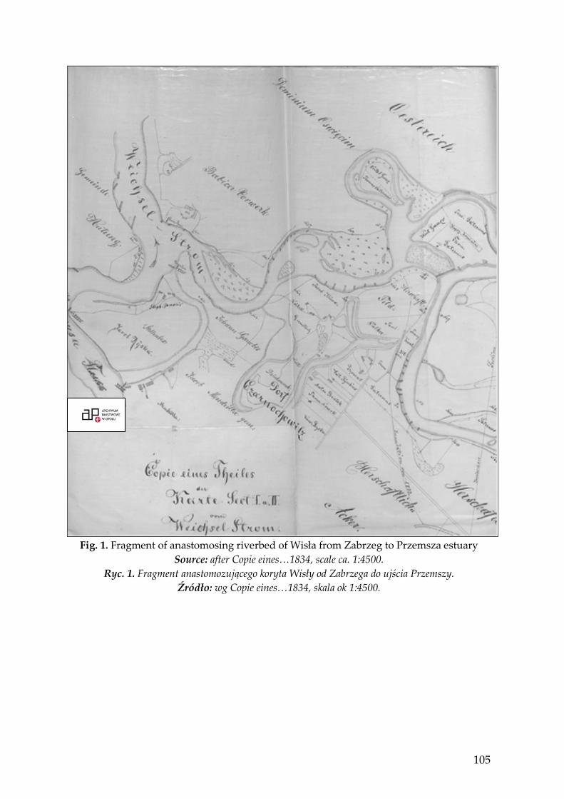
The transformation of the area, and therefore the surface hydrographical net-work within the valley of the Upper Wisła, began at a time when humans became interested in the valley and its development. At this stage, human activity aimed at finding and adapting sites possible for permanent settlement. Undoubtedly it took place at the dawn of the Polish state. In the following centuries the objective was mainly the economic use of land for cultivation and fish farming as well as shipping and trade. Agriculture in large rivers valleys started only at the end of the late Mid-dle Ages, when the then farmer learnt cultivation techniques of very fertile, but heavy and wet soils. Until the beginning of the 17th c. the valley was dominated by primeval riparian forests and wet meadows, while arable land occupied only a few dozen percent of its area. Only since the mid-18th c., people began cutting down forests and draining wet meadows for their adaptation into meadows and pastures and grain crops (fig. 2 and 3).
In the 17th and 18th c. the population inhabiting these areas could significantly alter the water balance in the Wisła valley. Large-scale fish farming allowed for naming these area the "Land of Ponds" or "Land of Frogs". It is estimated that in the 17th and 18th c. in the Wisła valley between the Strumień and the Skawa mouth there were more than 7,000 ponds in use with a total area of approx. 60 km2. Already in the 17th c. the course of the Wisła and its tributaries were changed. People built a dense network of millstreams, where the water power was used for sawmills, mills, fulleries and forges.
105
Fig. 1. Fragment of anastomosing riverbed of Wisła from Zabrzeg to Przemsza estuary
Source: after Copie eines…1834, scale ca. 1:4500. Ryc. 1. Fragment anastomozującego koryta Wisły od Zabrzega do ujścia Przemszy.
Źródło: wg Copie eines…1834, skala ok 1:4500.
106
Fig. 2. Fragment of Wisła valley in the region of Schwartzwasserischens Strumień
Settlement. Source: after Plan von situations… 1754. Ryc. 2. Fragment doliny Wisły w rejonie osady Schwartzwasserischens Strumień
Źródło: wg Plan von situations…1754.
Fig. 3. Fragment of Wisła valley in the region of Zabrzeg settlement.
Source: after Plan von situations…1754). Ryc. 3. Fragment doliny Wisły w rejonie osady Zabrzeg.
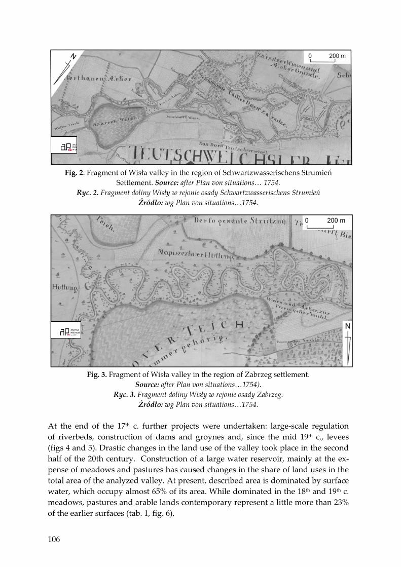
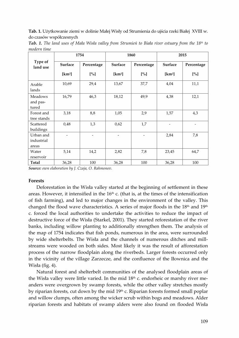
Źródło: wg Plan von situations…1754. At the end of the 17th c. further projects were undertaken: large-scale regulation of riverbeds, construction of dams and groynes and, since the mid 19th c., levees (figs 4 and 5). Drastic changes in the land use of the valley took place in the second half of the 20th century. Construction of a large water reservoir, mainly at the ex-pense of meadows and pastures has caused changes in the share of land uses in the total area of the analyzed valley. At present, described area is dominated by surface water, which occupy almost 65% of its area. While dominated in the 18th and 19th c. meadows, pastures and arable lands contemporary represent a little more than 23% of the earlier surfaces (tab. 1, fig. 6).
107
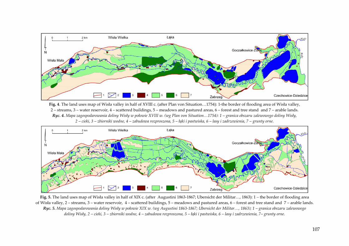
Fig. 4. The land uses map of Wisła valley in half of XVIII c. (after Plan von Situation…1754): 1-the border of flooding area of Wisła valley, 2 – streams, 3 – water reservoir, 4 – scattered buildings, 5 – meadows and pastured areas, 6 – forest and tree stand and 7 – arable lands. Ryc. 4. Mapa zagospodarowania doliny Wisły w połowie XVIII w. (wg Plan von Situation…1754): 1 – granica obszaru zalewowego doliny Wisły,
2 – cieki, 3 – zbiorniki wodne, 4 – zabudowa rozproszona, 5 – łąki i pastwiska, 6 – lasy i zadrzewienia, 7 – grunty orne.
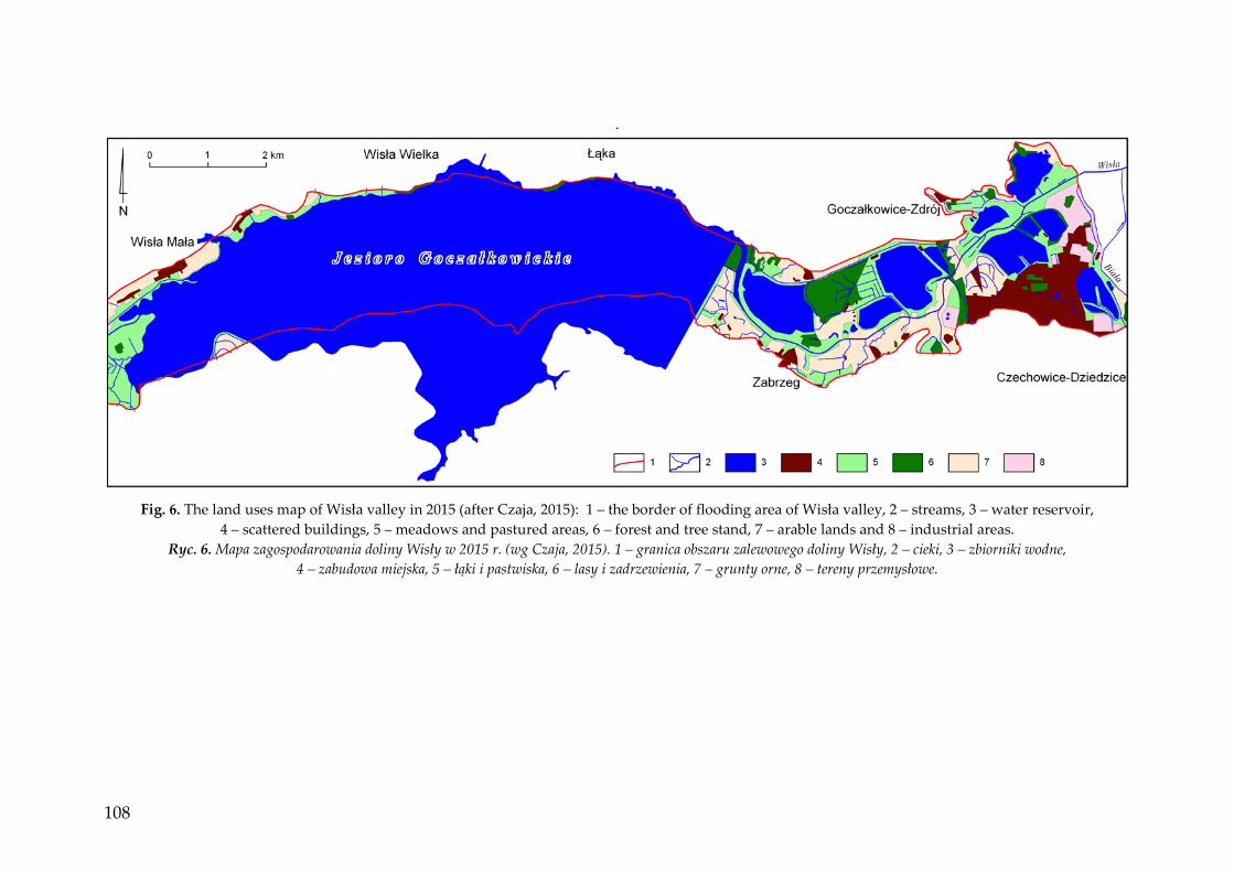
Fig. 5. The land uses map of Wisła valley in half of XIX c. (after Augustini 1863-1867; Ubersicht der Militar…, 1863): 1 – the border of flooding area
of Wisła valley, 2 – streams, 3 – water reservoir, 4 – scattered buildings, 5 – meadows and pastured areas, 6 – forest and tree stand and 7 – arable lands. Ryc. 5. Mapa zagospodarowania doliny Wisły w połowie XIX w. (wg Augustini 1863-1867; Ubersicht der Militar…, 1863); 1 – granica obszaru zalewowego
doliny Wisły, 2 – cieki, 3 – zbiorniki wodne, 4 – zabudowa rozproszona, 5 – łąki i pastwiska, 6 – lasy i zadrzewienia, 7– grunty orne.
108
.
Fig. 6. The land uses map of Wisła valley in 2015 (after Czaja, 2015): 1 – the border of flooding area of Wisła valley, 2 – streams, 3 – water reservoir,
4 – scattered buildings, 5 – meadows and pastured areas, 6 – forest and tree stand, 7 – arable lands and 8 – industrial areas. Ryc. 6. Mapa zagospodarowania doliny Wisły w 2015 r. (wg Czaja, 2015). 1 – granica obszaru zalewowego doliny Wisły, 2 – cieki, 3 – zbiorniki wodne,
4 – zabudowa miejska, 5 – łąki i pastwiska, 6 – lasy i zadrzewienia, 7 – grunty orne, 8 – tereny przemysłowe.
109
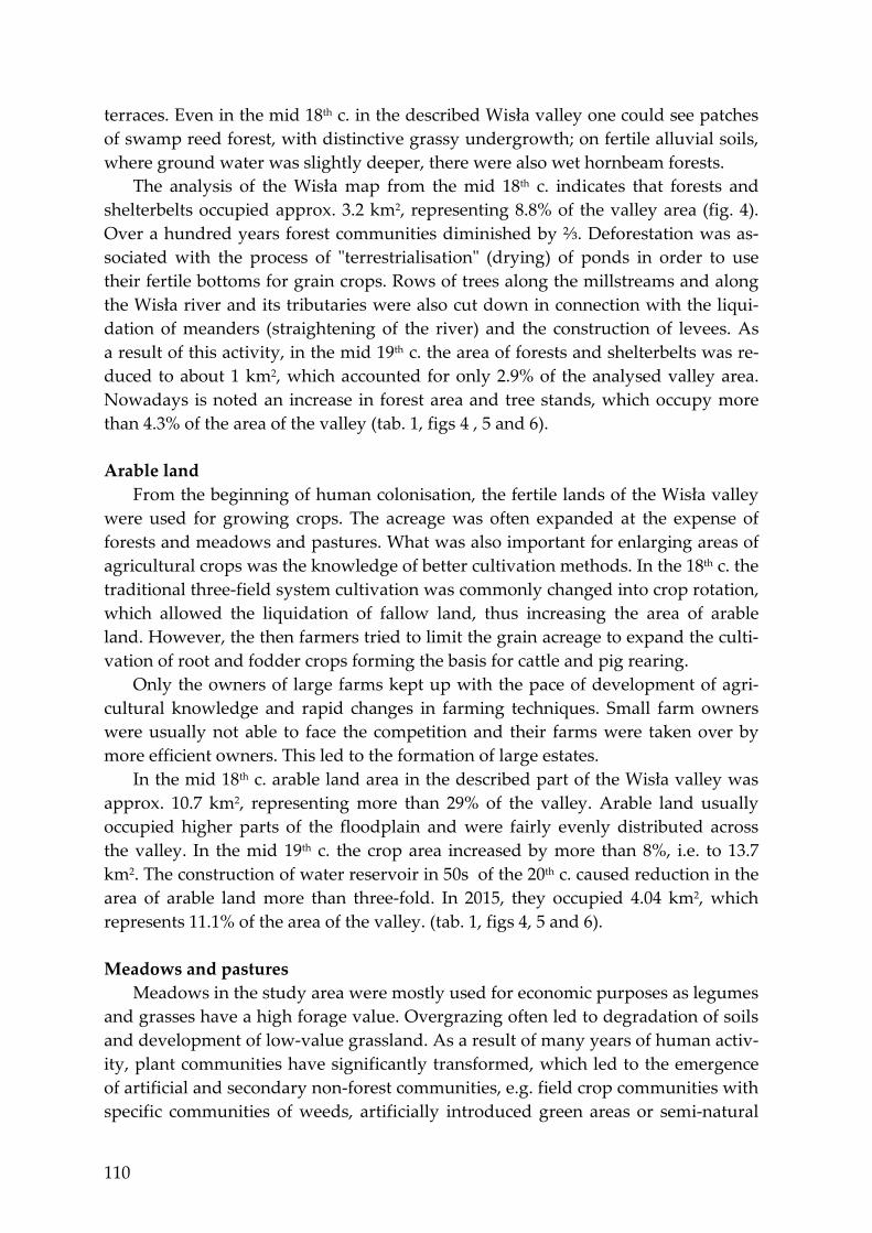
Tab. 1. Użytkowanie ziemi w dolinie Małej Wisły od Strumienia do ujścia rzeki Białej XVIII w. do czasów współczesnych Tab. 1. The land uses of Mała Wisła valley from Strumień to Biała river estuary from the 18th to modern time
Type of land use
1754 1860 2015
Surface
[km2]
Percentage
[%]
Surface
[km2]
Percentage
[%]
Surface
[km2]
Percentage
[%]
Arable lands
10,69 29,4 13,67 37,7 4,04 11,1
Meadows and pas-tured
16,79 46,3 18,12 49,9 4,38 12,1
Forest and tree stands
3,18 8,8 1,05 2,9 1,57 4,3
Scattered buildings
0,48 1,3 0,62 1,7 - -
Urban and industrial areas
- - - - 2,84 7,8
Water reservoir
5,14 14,2 2,82 7,8 23,45 64,7
Total 36,28 100 36,28 100 36,28 100 Source: own elaboration by J. Czaja, O. Rahmonov. Forests
Deforestation in the Wisła valley started at the beginning of settlement in these areas. However, it intensified in the 16th c. (that is, at the times of the intensification of fish farming), and led to major changes in the environment of the valley. This changed the flood wave characteristics. A series of major floods in the 18th and 19th c. forced the local authorities to undertake the activities to reduce the impact of destructive force of the Wisła (Starkel, 2001). They started reforestation of the river banks, including willow planting to additionally strengthen them. The analysis of the map of 1754 indicates that fish ponds, numerous in the area, were surrounded by wide shelterbelts. The Wisła and the channels of numerous ditches and mill-streams were wooded on both sides. Most likely it was the result of afforestation process of the narrow floodplain along the riverbeds. Larger forests occurred only in the vicinity of the village Zarzecze, and the confluence of the Iłownica and the Wisła (fig. 4).
Natural forest and shelterbelt communities of the analysed floodplain areas of the Wisła valley were little varied. In the mid 18th c. endorheic or marshy river me-anders were overgrown by swamp forests, while the other valley stretches mostly by riparian forests, cut down by the mid 19th c. Riparian forests formed small poplar and willow clumps, often among the wicker scrub within bogs and meadows. Alder riparian forests and habitats of swamp alders were also found on flooded Wisła
110
terraces. Even in the mid 18th c. in the described Wisła valley one could see patches of swamp reed forest, with distinctive grassy undergrowth; on fertile alluvial soils, where ground water was slightly deeper, there were also wet hornbeam forests.
The analysis of the Wisła map from the mid 18th c. indicates that forests and shelterbelts occupied approx. 3.2 km2, representing 8.8% of the valley area (fig. 4). Over a hundred years forest communities diminished by ⅔. Deforestation was as-sociated with the process of "terrestrialisation" (drying) of ponds in order to use their fertile bottoms for grain crops. Rows of trees along the millstreams and along the Wisła river and its tributaries were also cut down in connection with the liqui-dation of meanders (straightening of the river) and the construction of levees. As a result of this activity, in the mid 19th c. the area of forests and shelterbelts was re-duced to about 1 km2, which accounted for only 2.9% of the analysed valley area. Nowadays is noted an increase in forest area and tree stands, which occupy more than 4.3% of the area of the valley (tab. 1, figs 4 , 5 and 6). Arable land
From the beginning of human colonisation, the fertile lands of the Wisła valley were used for growing crops. The acreage was often expanded at the expense of forests and meadows and pastures. What was also important for enlarging areas of agricultural crops was the knowledge of better cultivation methods. In the 18th c. the traditional three-field system cultivation was commonly changed into crop rotation, which allowed the liquidation of fallow land, thus increasing the area of arable land. However, the then farmers tried to limit the grain acreage to expand the culti-vation of root and fodder crops forming the basis for cattle and pig rearing.
Only the owners of large farms kept up with the pace of development of agri-cultural knowledge and rapid changes in farming techniques. Small farm owners were usually not able to face the competition and their farms were taken over by more efficient owners. This led to the formation of large estates.
In the mid 18th c. arable land area in the described part of the Wisła valley was approx. 10.7 km2, representing more than 29% of the valley. Arable land usually occupied higher parts of the floodplain and were fairly evenly distributed across the valley. In the mid 19th c. the crop area increased by more than 8%, i.e. to 13.7 km2. The construction of water reservoir in 50s of the 20th c. caused reduction in the area of arable land more than three-fold. In 2015, they occupied 4.04 km2, which represents 11.1% of the area of the valley. (tab. 1, figs 4, 5 and 6). Meadows and pastures
Meadows in the study area were mostly used for economic purposes as legumes and grasses have a high forage value. Overgrazing often led to degradation of soils and development of low-value grassland. As a result of many years of human activ-ity, plant communities have significantly transformed, which led to the emergence of artificial and secondary non-forest communities, e.g. field crop communities with specific communities of weeds, artificially introduced green areas or semi-natural
111
wet communities with fragments of rush communities in wetlands often used as pastures (Czylok, Szczypek, Wika, 1997).
Meadows and pastures are most common in the areas with high water table level. In the study area these were found along the Wisła on both its sides, creating a wide belt stretching along the entire course of the river and its tributaries. They were also found near the fish ponds and in the areas further away from farm buildings.
In the mid 18th c., meadows and pastures occupied almost 16.8 km2, which ac-counted for over 46% of the area of the described valley. By mid-19th c. the acreage of this land use form rose slightly to 18.1 km2, which accounted for 50% of the valley. The increase in the share of this form of land use in the Mała Wisła valley took place mainly at the expense of forests and shelterbelts. Located in the analyzed part of the Wisła valley Lake Goczałkowice took mostly wetlands meadows and pastures. Their area has decreased four times and nowadays occupy about 12% of the area of the valley. Low density housing and communication routes
In the 18th c. and the first half of the 19th c. there was only low density housing in the Wisła valley. These were usually single houses and farm buildings with gardens and orchards nearby. There were also farm buildings such as sawmills, mills, fuller-ies and forges built on a dense network of millstreams (figs 2 and 3). These build-ings were administered by the villages of Czechowice, Goczałkowice, Zarzecze, Za-brzeg and Strumień. These settlements were located on meadow terraces or plateau slopes and therefore outside the described area of the Wisła valley. In the mid 18th c. low density housing occupied nearly 0.5 km2, representing approx. 1.3% of the Wisła valley area. Over the next hundred years, no significant changes were record-ed to the surface occupied by housing, farm buildings and the above mentioned buildings providing services to the local community. In 1860, this type of buildings occupied 0.62 km2, representing 1.7% of the area of the Wisła valley.
In the 18th c. and the first half of the 19th c. communication network in the Wisła valley usually consisted of unpaved dirt roads. They were built on both sides of the Wisła, most commonly along the edges of the areas flooded during catastrophic floods. In the mid 18th c. dirt roads were almost 46 km long. Of great importance were also roads conducted on embankments and dykes of numerous ponds (figs 2 and 3). Their total length was almost 26 km. Liquidation of many ponds by the mid 19th c. led to a reduction in the length of roads along dikes to about 18 km and a slight increase in dirt roads – up to 49 km. It is worth mentioning that until the mid 19th c. the area described had only one bridge crossing over the Wisła in the vicinity of the village Zarzecze.
Beginning, at the turn of the XIX and XX century the exploitation of coal mining in the area of the estuary of the river Biała to the Wisła, it caused the development of urban and industrial infrastructure. Actually these area cover more than 2.80 km2, which is 7.8% of valley surface. The changes in land use caused also the liqui-dations of roads around the ponds and led to the reducing of the length ground roads to about 20 km.
112
SURFACE HYDROGRAPHIC NETWORK River system
The fluvial system of the Mała Wisla its basin is a complex system, both when it comes to the age and origin of its individual parts, as well as the mechanisms of flow and movement of waste material, which are associated with a predominance of rainfall flooding shaped in the mountainous part of the basin. The impact of many interdependent elements of the environment exerts a huge impact on the functioning and intensity of fluvial processes, which are manifested by different types of riverbeds. The most important elements of the natural environment in-clude: geology and terrain, climatic conditions and vegetation cover. The amount, distribution and intensity of rainfall exert the most important influence on the run-off from the catchment. They decide on river flow, flood magnitude and fluctua-tions of water levels; this in turn has an impact on the ability to transfer a certain amount and size of products of weathering by the river.
As is clear from the study of Czaja, Degórska and Leśniok (1993), the described river stretch does not take major tributaries, so it can be considered homogeneous in hydrological terms. The regime of the Wisła at this stretch is shaped by almost equivalent summer and spring freshets. They show rapid runoff and consequently uneven daily flows. Freshets in the summer months, however, are higher. They are evoked by simultaneous rain throughout the source part of the Wisła and its moun-tain tributaries Iłownica and Biała. The Wisła riverbed in the study area is flat-bottomed, mostly meandering, with the geometry controlled by the said hydrologi-cal regime. The river valley drop is small. Flowing, it cuts through the areas covered by loose quaternary sediments with a thickness greater than a few meters. In most cases such riverbeds show a reduced width relative to the depth.
At the end of the Little Ice Age and the early years of modern climate change (18th and 19th c.), an increase in the frequency of freshets increased, which were the cause of straightening, indentation and the formation of braided channels. In the years 1772-1778, as well as in 1813, 1831 and 1854, a series of catastrophic floods on the Mała Wisła were recorded; they caused major changes in the riverbed course in the analysed part of the valley. In the village of Mała Wisła, which lies a few kilo-metres west of Goczałkowice, floods at the end of the 18th c. resulted in breaching the Wisła bed and setting a new course of the river. The maximum distance be-tween the riverbeds reached about 1110 m, and the length of the river at this stretch was shortened from 7.2 to 5.5 km. In contrast to the rest of the Wisła channel where the river meanders, on the said stretch anastomosing processes predominate. In the 19th c. the Wisła riverbed remained almost unchanged.
In addition to natural causes of the changes in the river network, an important role in shaping it was exerted directly by human activity. Between the 17th and 19th c. settlements in the study area were located in the river and stream valleys in such a way that the edge of the rural built-up area reached the limit of maximum Wisła flooding (Czaja, 2010). However, in the floodplain intensive activity was conducted.
113
Already in the 18th c. riverbeds were shifted and networks of millstreams were built to locate mills, sawmills, fulleries and forges. In the first half of the 19th c., a large-scale drainage of wet meadows and pastures began as well as the construction of bank strengthening, groynes, weirs and embankments.
In the 18th and 19th c. the surface hydrographic network of the Wisła was very well developed. However, its shape was mainly determined by human activity. In the mid 18th c. the channels of the natural watercourses (Wisła and estuary stretches of the Iłownica and Biała) had a length of approx. 46.7 km, representing 52.4% of the hydrographic network of the study area. The remaining 42.5 kilometres were millstreams running parallel to the Wisła.
Development of a new Wisła riverbed after floods in the late 18th c. as well as the reclamation works started in the 19th c., changed the length of watercourses and ar-rangement of hydrographic network of the study area. Drainage works were car-ried out mainly in the Prussian part of the Wisła valley, in the area of the modern-day Goczałkowice reservoir. As a result of a new Wisła channel and a network of drainage ditches, the total length of the hydrographic network increased to about 135.5 km. Natural watercourses were approx. 50.6 km long, representing only 37% of the hydrographic network of the study area. The construction of water reservoir caused significant changes in the length of the river network. Today's Wisła river channel and its tributaries are only 12.4 kilometres and representing only 9% of the length of the river network from the mid-XIX century (tab. 1, fig. 6) Fish ponds
Besides their important retention role, numerous fish ponds in the Mała Wisła valley also represent an important economic sector in this area. Their importance in the past was much greater, because together with millstreams and watercourse damming they were used to propel facilities of mills, sawmills, fullers and forges. Fish farming served a very important role in the development of the region since the 13th–14th c. when Cistercian monks began carp breeding in the monastery ponds. Intensive development of fish farming in the area took place in the 16th and 17th c.
However, in the 18th c., the number and size of ponds decreased significantly, due to continuous drainage and conversion into farmland. According to the manual by O. Strumieński of 1578, the then built ponds had a depth of from 0.5 to 3.0 m and enabled lowering the water to catch fish and dry the bottom in winter. Shallow depth as well as mixing the water and drying the bottom in winter are important for me-tabolism taking place in the waters. In the study area the ponds substrate are mainly clay and dust deposits. This is important in fish farming, as the clay deposits seal well the bottom of the ponds. As a result they prevent loss of water and mineral nutrient compounds.
In the mid 18th c. there were 25 fish ponds with a total area of approx. 5.14 km2 in the Wisła floodplain between Strumień and the mouth of the Biała. In the mid 19th c., their number fell slightly (to 21), but their surface area was significantly reduced – to 2.82 km2.
114
Existing contemporary reservoirs basically ceased to fulfill the functions of farmed. For these purposes, uses only 6 of the 18 existing reservoirs. In addition, a complex of ponds located north of Czechowice-Dziedzic founded in the area of mining subsidence and basin have been significantly transformed, and contain polluted water (Czaja, 2015). SUMMARY AND CONCLUSIONS
Throughout its history, the modern system of the Mała Wisła basin underwent multiple transformations. These were changes in the physiographic conditions, of which the greatest impact was played by hydrometeorological factors. However, over the last three hundred years a decisive role in the changes taking place in the catchment was human activity. River valleys very clearly reflect the changes taking place in the whole basin. Elements of the valley, such as structure and arrangement of terraces, river network, vegetation, etc., include a record of natural and anthro-pogenic changes. The analysis of land use changes in the Mała Wisła floodplain along the stretch between Strumień to the mouth of the Biała in the years 1754-2015 indicates the following:
1. The biggest change in the area was evoked by forests and shelterbelts, as in a hundred years (1754 – 1860) their area decreased three times – from 3.18 km2 to 1.05 km2 while in 2015 year their surface increased to 1.57 km2.
2. A major change referred also to the number and area of fish ponds as well as the surface area of the hydrographic network. In the mid 18th c. there were 25 ponds in the valley with a total area of 5.14 km2, while in 1860 there were only 21 ponds with an area of 2.82 km2, while in 2015 year 18 water reservoirs with a total area of 23.45 km2. However, the river network was extended (in the turn of the XIX and XX c.) by more than 50%, and its distribution and channel character also changed. After the construction of water reservoir and the flooding over 60% of an-alyzed valley, the surface hydrographic network is reduced to 12.4 km.
3. Until the mid-20th c. the surface area of arable land as well as meadows and pastures changed very little, since they increased by a few percent. Drastic changes occurred after the construction of water reservoir, when the share of these land uses of the valley decreased almost fourfold (tab. 1).
4. To the mid-20th century in the described area dominated dispersed habita-tion, whose share in the overall land use in Mała Wisła valley ranged from 1.3 to 1.7%. The development of industry and urbanization which initiated in and of XIX c. caused also changes in the structure of building. Nowadays here it is dominated by compact cities and industrial buildings, which occupies 7.8% of the area of Mała Wisła valley.
115
LITERATURA Augustini J., 1863-1867: General karte des Furstenhums Pless, 1:25000. Zbiory
Kartograficzne Archiwum Państwowego Katowice [rękopis]. Bielański A.K., 1997: Materiały do historii powodzi w dorzeczu górnej Wisły (opr.
J. Fiszer), monografie politechniki krakowskiej, nr 217. Copie eines Theiles der Karte Sect I u. II von Weichsel Strom 1834, skala około
1:4500. Zbiory Kartograficzne Archiwum Państwowego w Opolu. Czaja J., 2015: Zagrożenie powodziowe terenów miasta i gminy Czechowice-
Dziedzice (Kotlina Oświęcimska) [w:] Z badań nad wpływem antropopresji na środowisko przyrodnicze (red.) R. Machowski, M.A., Rzętała, Prace Wydziału Nauk o Ziemi Uniwersytetu Śląskiego nr 84: 9-20.
Czaja S., 2010: Zmiany krajobrazów doliny Małej Wisły w obrębie Kotliny Oświę-cimskiej przez wezbrania powodziowe w XVIII-XX w. Prace Komisji Krajobrazu Kulturowego, nr 13: 29-40.
Czaja S., Degórska V., Leśniok M., 1993: Naturalne i antropogeniczne zmiany kory-ta Wisły od zbiornika w Gocząłkowicach do ujścia Przemszy. Geographia. Studia et dissertationes, UŚ.
Czylok A., Szczypek T., Wika S., 1997: Zasoby przyrody żywej w dolinie Wisły między Mętkowem a Rozkochowem (Kotlina Oświęcimska) jako tło dla eksplo-atacji kruszywa. WNoZ UŚ, Sosnowiec – Dąbrowa Górnicza.
Lageplan der Klainen Weichsel Kreis Pless, ok 1895, 1:75000. Zbiory Kartograficzne Archiwum Państwowego w Opolu.
Nita J., Myga-Piątek U., 2012: Rola GIS w ocenie historycznych opracowań karto-graficznych na przykładzie Wyżyny Częstochowskiej. Prace Komisji Krajobrazu Kulturowego, 16: 116-135.
Plan von situation des Wiechsel und dessen Lauff von der Schwartzwasserischen graentze bis anden Flussbiala und das Konigreich Pohlen…1754, skala ok 1:4200, Zbiory Kartograficzne Archiwum Państwowego w Opolu.
Starkel L., 2001: Historia doliny Wisły od ostatniego zlodowacenia do dziś. IG i PZ PAN, Warszawa.
Szewczuk J., 1939: Kronika klęsk elementarnych w Galicji 1772 – 1848. [w:] Badania z dziejów społecznych i gospodarczych. Pod red. Prof. Fr. Bujaka, 35, Lwów, (Przedmowa 92 s): 336 s.
Ubersicht der Militar Aufnahme von Mahren und Schlesien, 1861-1863, 1:28800. Archiwum kartograficzne, Wiedeń.
Zachariasz A., 2012: Przydatność archiwalnych źródeł kartograficznych dla współ-czesnych badań krajobrazowych. Prace Komisji Krajobrazu Kulturowego, 16: 63-83.