691-694 geoy3907 jakob
5
Geology doi: 10.1130/G32153.1 published online 24 May 2011; Geology Wojciech Majewski Björn Eriksson, Alexandra Kirshner, Rodrigo Fernandez, Travis Stolldorf, Rebecca Minzoni and Nina Kirchner, Rezwan Mohammad, Matthew O'Regan, Richard B. Alley, Sridhar Anandakrishnan, Martin Jakobsson, John B. Anderson, Frank O. Nitsche, Julian A. Dowdeswell, Richard Gyllencreutz, Bay, West Antarctica Geological record of ice shelf break-up and grounding line retreat, Pine Island Email alerting services articles cite this article to receive free e-mail alerts when new www.gsapubs.org/cgi/alerts click Subscribe to subscribe to Geology www.gsapubs.org/subscriptions/ click Permission request to contact GSA http://www.geosociety.org/pubs/copyrt.htm#gsa click official positions of the Society. citizenship, gender, religion, or political viewpoint. Opinions presented in this publication do not reflect presentation of diverse opinions and positions by scientists worldwide, regardless of their race, includes a reference to the article's full citation. GSA provides this and other forums for the the abstracts only of their articles on their own or their organization's Web site providing the posting to further education and science. This file may not be posted to any Web site, but authors may post works and to make unlimited copies of items in GSA's journals for noncommercial use in classrooms requests to GSA, to use a single figure, a single table, and/or a brief paragraph of text in subsequent their employment. Individual scientists are hereby granted permission, without fees or further Copyright not claimed on content prepared wholly by U.S. government employees within scope of Notes articles must include the digital object identifier (DOIs) and date of initial publication. priority; they are indexed by PubMed from initial publication. Citations to Advance online prior to final publication). Advance online articles are citable and establish publication yet appeared in the paper journal (edited, typeset versions may be posted when available Advance online articles have been peer reviewed and accepted for publication but have not © Geological Society of America as doi:10.1130/G32153.1 Geology, published online on 24 May 2011
Transcript of 691-694 geoy3907 jakob

Geology
doi: 10.1130/G32153.1 published online 24 May 2011;Geology
Wojciech MajewskiBjörn Eriksson, Alexandra Kirshner, Rodrigo Fernandez, Travis Stolldorf, Rebecca Minzoni andNina Kirchner, Rezwan Mohammad, Matthew O'Regan, Richard B. Alley, Sridhar Anandakrishnan, Martin Jakobsson, John B. Anderson, Frank O. Nitsche, Julian A. Dowdeswell, Richard Gyllencreutz, Bay, West AntarcticaGeological record of ice shelf break-up and grounding line retreat, Pine Island
Email alerting servicesarticles cite this article
to receive free e-mail alerts when newwww.gsapubs.org/cgi/alertsclick
Subscribe to subscribe to Geologywww.gsapubs.org/subscriptions/click
Permission request to contact GSAhttp://www.geosociety.org/pubs/copyrt.htm#gsaclick
official positions of the Society.citizenship, gender, religion, or political viewpoint. Opinions presented in this publication do not reflectpresentation of diverse opinions and positions by scientists worldwide, regardless of their race, includes a reference to the article's full citation. GSA provides this and other forums for thethe abstracts only of their articles on their own or their organization's Web site providing the posting to further education and science. This file may not be posted to any Web site, but authors may postworks and to make unlimited copies of items in GSA's journals for noncommercial use in classrooms requests to GSA, to use a single figure, a single table, and/or a brief paragraph of text in subsequenttheir employment. Individual scientists are hereby granted permission, without fees or further Copyright not claimed on content prepared wholly by U.S. government employees within scope of
Notes
articles must include the digital object identifier (DOIs) and date of initial publication. priority; they are indexed by PubMed from initial publication. Citations to Advance online prior to final publication). Advance online articles are citable and establish publicationyet appeared in the paper journal (edited, typeset versions may be posted when available Advance online articles have been peer reviewed and accepted for publication but have not
© Geological Society of America
as doi:10.1130/G32153.1Geology, published online on 24 May 2011

GEOLOGY, July 2011 691
ABSTRACTThe catastrophic break-ups of the fl oating Larsen A and B ice
shelves (Antarctica) in 1995 and 2002 and associated acceleration of glaciers that fl owed into these ice shelves were among the most dramatic glaciological events observed in historical time. This raises a question about the larger West Antarctic ice shelves. Do these shelves, with their much greater glacial discharge, have a history of collapse? Here we describe features from the seafl oor in Pine Island Bay, West Antarctica, which we interpret as having been formed during a massive ice shelf break-up and associated grounding line retreat. This evidence exists in the form of seafl oor landforms that we argue were produced daily as a consequence of tidally infl uenced motion of mega-icebergs maintained upright in an iceberg armada produced from the disintegrating ice shelf and retreating ground-ing line. The break-up occurred prior to ca. 12 ka and was likely a response to rapid sea-level rise or ocean warming at that time.
INTRODUCTIONGlaciologists have long recognized that ice shelves stabilize ice
sheets by buttressing the outward fl ow of glaciers and ice streams fl ow-ing into them. Hughes (1977) argued that the Pine Island and Thwaites glaciers (Antarctica) were particularly unstable because they punched through their ice shelves. Together, these two glaciers deliver to the sea nearly 30% of ice drainage from the West Antarctic Ice Sheet (Fig. 1), so their rapid retreat could signifi cantly increase global sea-level rise (Rignot et al., 2008; Thomas et al., 2004). Pine Island Glacier has been affected by rapid ice shelf thinning, negative mass balance, fl ow acceleration, and rapid grounding-line retreat in historical time (Rignot et al., 2002; Rignot, 1998; Wingham et al., 2009). These changes are interpreted to be caused by melting of the ice shelf from underneath by impinging warm deep oceanic water (Jenkins et al., 2010; Shepherd et al., 2001).
During the Last Glacial Maximum (LGM), Pine Island and Thwaites glaciers converged into a single ice stream that delivered a substantial fraction of the West Antarctica discharge through Pine Island Trough within Pine Island Bay (Graham et al., 2010; Lowe and Ander-son, 2002). During the 2009–2010 austral summer, Pine Island Bay was virtually ice free, allowing us to conduct detailed swath bathymetry mapping covering 4140 km2 of central Pine Island Trough (Fig. 1).
These new data provide images of the seafl oor with unprecedented resolution and show landforms that were produced as the ice sheet retreated from Pine Island Trough, including features that we argue formed from tidal motions of mega-icebergs produced during an episode of ice shelf break-up and rapid grounding line retreat.
DATA ACQUISITIONThe swath bathymetric data were collected from Swedish icebreaker
Oden during the expedition Oden Southern Ocean 0910 (OSO0910). Icebreaker Oden is equipped with a Kongsberg 12 kHz EM122 1° × 1° multibeam echo sounder. The multibeam system includes a Seatex Seapath 200 unit for integration of global positioning system naviga-tion, heading, and attitude information. The motion sensor was a Seatex MRU5. The multibeam data were processed using Interactive Visualiza-tion Systems (IVS 3D) Fledermaus software and gridded to a horizontal resolution of 20 m × 20 m.
RESULTSOur data reveal a range of geomorphic features including linear to
curvilinear sets of furrows that are aligned parallel to the axis of the trough and have a spacing of 150 m to >500 m. These features occur within the relatively fl at fl oor of the trough at water depths between 690 and 710 m (Fig. 2). Remarkably regular sets of ridges occur within the furrows and are oriented at close to right angles to them (Fig. 2). These ridges range in height between 1 and 2 m from trough to crest. Crests are separated by ~60–200 m, with spacing generally decreasing progressively in a seaward
Geology, July 2011; v. 39; no. 7; p. 691–694; doi:10.1130/G32153.1; 4 fi gures; Data Repository item 2011212.© 2011 Geological Society of America. For permission to copy, contact Copyright Permissions, GSA, or [email protected].
Geological record of ice shelf break-up and grounding line retreat, Pine Island Bay, West AntarcticaMartin Jakobsson1, John B. Anderson2, Frank O. Nitsche3, Julian A. Dowdeswell4, Richard Gyllencreutz1, Nina Kirchner5, Rezwan Mohammad1, Matthew O’Regan1, Richard B. Alley6, Sridhar Anandakrishnan6, Björn Eriksson1, Alexandra Kirshner2, Rodrigo Fernandez2, Travis Stolldorf2, Rebecca Minzoni2, and Wojciech Majewski71Department of Geological Sciences, Stockholm University, 106 91 Stockholm, Sweden2Department of Earth Sciences, Rice University, Houston, Texas 77005, USA3Lamont-Doherty Earth Observatory of Columbia University, Route 9 W, Palisades, New York 10964, USA4Scott Polar Research Institute, University of Cambridge, Cambridge CB2 1ER, UK5Department of Physical Geography and Quaternary Geology, Stockholm University, 106 91 Stockholm, Sweden6Department of Geosciences, Pennsylvania State University, University Park, Pennsylvania 16802, USA7Institute of Paleobiology, Polish Academy of Sciences, Twarda 51/55, 00-818 Warsaw, Poland
Figure 1. Overview map showing track of icebreaker Oden during OSO0910 expedition, and general bathymetry of Pine Island Bay updated from most recent bathymetric compilation (Nitsche et al., 2007). Bathymetric troughs carved by Pine Island and Thwaites paleo-ice streams are marked by arrows. RI—Ross Ice Shelf; FRI—Filchner-Ronne Ice Shelf.
as doi:10.1130/G32153.1Geology, published online on 24 May 2011

692 GEOLOGY, July 2011
direction (Fig. 3). The extremely regular shape of the ridges may at fi rst suggest that they are processing or acoustic artifacts. However, they are not, because the orientations are consistent despite changes in the ship’s heading. Sediment cores from these features are composed of poorly sorted glacial diamict and glacimarine sandy clays, indicating that they were not deposited by currents. We refer to these features as corrugation ridges and describe the furrows as corrugated furrows.
The corrugated furrows in Pine Island Bay are virtually identical to features previously imaged using side-scan sonar in the northeastern Wed-dell Sea (Barnes and Lien, 1988; Lien, 1981) and Ross Sea (Shipp et al., 1999). In Pine Island Bay, where water depths decrease abruptly seaward, corrugated furrows terminate as individual iceberg furrows (Fig. 2). In the Ross Sea, corrugated lineations also occur in a relatively fl at portion of the trough (water depths of 626–647 m), but the seafl oor rises seaward more gradually than in Pine Island Bay. There, corrugation ridges oriented roughly transverse to lineations transition seaward into ridges with more variable orientations (see the GSA Data Repository1). Further seaward there are discrete corrugated furrows with more variable spacing and direc-tions, even crosscutting one another (see the Data Repository). Side-scan sonar images from the Weddell Sea imply a similar transition in bedforms, although data coverage there is sparse (Barnes and Lien, 1988; Lien, 1981). We also imaged corrugated furrows in the eastern Ross Sea during our tran-sit to Pine Island Bay (see the Data Repository). Corrugated furrows have been imaged in several areas of the Antarctic continental shelf where high-resolution seafl oor images have been acquired. Their pervasive occurrence suggests a common mechanism and explanation for their origin.
FORMATION MODELWe considered several mechanisms for the formation of corruga-
tion ridges (Table DR1 in the Data Repository). Because of their extreme regularity, we ruled out the possibility that they were recessional moraines formed at or close to the ice margin. This would require margin retreat
1GSA Data Repository item 2011212, additional seafl oor images of glacigenic features from Pine Island Bay and the Ross Sea, a table of considered landforms and formation models for corrugation ridges, and 14C dating results from Pine Island Bay, is available online at www.geosociety.org/pubs/ft2011.htm, or on request from [email protected] or Documents Secretary, GSA, P.O. Box 9140, Boulder, CO 80301, USA.
Figure 2. A: Swath bathymetric image of middle Pine Island Trough. B: Enlarged bathymetric image shows corrugation ridges and cor-rugated iceberg furrows that crosscut them. Analysis of bathymetric profi le between A and A′ is shown in Figure 3. C: Map showing dis-tribution of landforms. MSGL—mega-scale glacial lineations. D: En-largement of area showing relation between corrugated ridges, sets of corrugated furrows, and individual iceberg furrows that terminate in iceberg plow ridges.
Figure 3. Analysis of bathymetric profi le A-A′ (profi le location shown in Fig. 2A). A: Bathym-etry derived from mul-tibeam data is shown with green curve. Depth data were detrended before being analyzed (blue curve). Peaks and troughs of corrugation ridges were identifi ed (red stars and black cir-cle, respectively) for fur-ther dimensional analy-
sis. B: Calculated distances between the ridges. Mean ridge spacing along profi le is 116.5 m and median 101 m; maximum calculated distance between two ridges is 301 m and minimum is 58 m. There is slight increase in distance between ridges from A to A′, as illustrated by red regres-sion line. C: Peak-to-trough heights along bathymetric profi le from A to A′. Extracted time series of modeled tidal fl uctuations in Pine Island Bay is plotted as comparison, assuming that one corrugation ridge is formed every day (24 h). D: Spectral analysis of calculated ridge heights as-suming that one ridge is formed every 24 h. Spectral peaks of modeled tide in Pine Island Bay shown as comparison.
as doi:10.1130/G32153.1Geology, published online on 24 May 2011
GEOLOGY, July 2011 693
by repeated calving of identical icebergs in every cycle, a highly improb-able process. We thus discard the interpretations that they are De Geer moraines (Hoppe, 1959; Lindén and Möller, 2005), corrugation moraines (Shipp et al., 1999), or transverse ridges (Dowdeswell et al., 2008b), all of which have been interpreted as annual features (Table DR1). The main morphological difference between corrugation ridges and these annual moraines is that the latter are considerably more irregular in all aspects (e.g., spacing, amplitude, and continuity), and tend to be larger.
Another alternate mechanism we considered calls for squeezing of sediment into basal crevasses of a grounded ice mass (e.g., see Clark, 1993). To date, there are no large-scale images of the base of an ice shelf, although autonomous underwater vehicle swath data suggest that under-sides of ice shelves are highly irregular over stretches (Dowdeswell et al., 2008a), and we are not aware of any theoretical studies that have inferred such widespread, regularly spaced crevasses beneath ice shelves. We have examined surface crevasses on modern ice shelves and ice streams, but our analysis has shown that surface crevasses are highly irregular compared to corrugation ridges. Physical understanding of fracture nucleation and propagation (Schulson, 2001) confi rms these observations. Dependence on grain size, as well as preexisting fl aws and other aspects of the ice inevitably include some random variation. Indeed, ridges known to have formed as basal crevasse fi lls exhibit notable irregularity (Mickelson and Berkson, 1974). Because of the great water depth, rapid thinning would be required to allow the ice to fl oat free of its basal crevasse fi lls and drift away without disturbing them, and this seems unrealistic.
Several observations are relevant in examining the formation of the corrugated furrows in Pine Island Bay. First, they are confi ned to the rela-tively fl at portion of the trough. Second, they have fairly uniform spacing and consistent bends or kinks are repeated accurately from one to the next (Fig. 2B). This implies formation by a relatively coherent but highly frac-tured (parallel to fl ow) mass of ice that extended across the deepest part of the trough, a minimum width of 14 km. The spacing of the lineations is similar in scale to megascale glacial lineations, so the two are probably genetically related. The seaward transition from parallel corrugated fur-rows to ones with more variable directions, specifi cally observed in the eastern Ross Sea, indicates a similar mechanism for the formation of the ridges, one that was active even after the larger ice mass broke up into icebergs that drifted randomly across the shelf.
The striking regularity of the corrugation ridges indicates a periodic forcing. We believe that tides provide the simplest and most obvious peri-odic forcing with suffi cient regularity and power at sub-Milankovitch fre-quencies. To test the tidal mechanism, we examined the possible infl uence of spring-neap versus diurnal tides in regulating the spacing and height of ridges using Padman et al.’s. (2002) tidal model (Fig. 3). Consistent with the tidal model, quasi-periodic fl uctuations in ridge heights are observed, assuming that ridges are formed daily, with higher ridges forming roughly every two weeks (Fig. 3D). Typical present-day tidal ranges under Antarc-tic ice shelves are ~1–2 m peak to peak, and 2–4 m at spring tides (Padman et al., 2002). This is in close agreement with the measured range of ridge heights in Pine Island Bay (Fig. 3C). No cyclical pattern is observed in the distance between ridges, but the spacing decreases progressively in a seaward direction, implying that ice drift rates decreased with time. This latter effect may refl ect a decrease in offshore winds and/or surface cur-rents as the ice drifted seaward away from the ice sheet, combined with slowing of the drift as individual icebergs pushed against the bed, which rises in the direction of drift.
Given a tidal mechanism for corrugation ridge formation, the spacing of ridges implies 60–200 m of ice movement per day (Fig. 3B), exception-ally fast for grounding-line retreat. Furthermore, grounding-line retreat does not explain the seaward transition into crosscutting iceberg furrows with similarly spaced ridges (Fig. 2B; see the Data Repository). Why would the grounding line retreat at about the same rate as iceberg drift
rates? Rather, the rates are consistent with iceberg behavior. For exam-ple, the ice mélange in the fjord of Jakobshavn Glacier moves ~40 m/day between major calving events (Amundson et al., 2010). The rates are an order of magnitude slower than the drift velocity achieved by the large iceberg B-9 calved from the Ross Ice Shelf (Keys et al., 1990), but B-9 was not grounded during its drift, whereas the Pine Island Trough bergs must have been slowed by interaction with the bed.
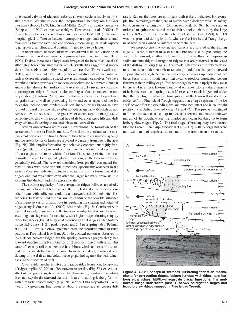
We propose that the corrugated furrows are formed at the trailing edge of a large, coherent mass of ice that breaks off at the grounding line and drifts seaward, rhythmically settling to the seafl oor and squeezing sediments into ridges (corrugation ridges) that are preserved in the wake of the drifting icebergs (Fig. 4). This model calls for a uniformly thick ice mass that is just thick enough to remain grounded on the gently upward sloping glacial trough. As the ice mass begins to break up, individual ice-bergs begin to shift, rotate, and fl oat away to produce corrugated iceberg furrows at their trailing edge. For the icebergs to remain upright they must be encased in a thick fl oating canopy of ice, most likely a thick armada of icebergs from a collapsing ice shelf, or else be much longer and wider than they are high. Unlike the disintegration of the Larsen B ice shelf, the evidence from Pine Island Trough suggests that a large segment of the ice shelf broke off at the grounding line and remained intact and in an upright position as it drifted seaward (Figs. 4B and 4C). The process continued until the deep keel of the collapsing ice shelf reached the outer, shallower margin of the trough, where it grounded and began breaking up to form iceberg plow ridges (Fig. 2). The fi nal stage of breakup may have resem-bled the Larsen B breakup (MacAyeal et al., 2003), with icebergs that were narrower than their depth capsizing and drifting freely from the trough.
Figure 4. A–C: Conceptual sketches illustrating formation mecha-nisms for corrugation ridges, iceberg furrows with ridges, and ice-berg plow ridges. MSGL—megascale glacial lineations. The mul-tibeam image underneath panel C shows corrugation ridges and iceberg plow ridges mapped in Pine Island Trough.
as doi:10.1130/G32153.1Geology, published online on 24 May 2011

694 GEOLOGY, July 2011
The breakout of the Pine Island ice shelf and associated ground-ing-line retreat occurred prior to ca. 12 ka based on radiocarbon ages from proximal glacimarine sediments above till within the trough and on a prominent grounding-zone wedge located landward of the trough (Table DR2). This was a time of rapid sea-level rise (Fairbanks, 1989; Rabineau et al., 2006), and a time of notable southern warming (e.g., Broecker et al., 2010), and these likely initiated grounding-line instability and associated ice shelf disintegration. The modern grounding line is situ-ated in an area of rugged bedrock topography, so sea-level rise is not con-sidered to be a current threat to grounding-line stability, although warming may be (e.g., MacAyeal et al., 2003). Our results indicate that massive breakout of ice shelves, extending all the way to the grounding line, has occurred in the past, and that this has important implications with regard to ice sheet behavior and sea-level history.
ACKNOWLEDGMENTSThe expedition was carried out as collaboration between Swedish Polar
Research Secretariat, the Swedish Research Council, and the U.S. National Sci-ence Foundation (NSF). We thank the captain and crew of the icebreaker Oden. Financial support was received from the Swedish Research Council, the Swedish Royal Academy of Sciences through a grant fi nanced by the Knut and Alice Wal-lenberg Foundation, and the Bert Bolin Centre for Climate Research at Stockholm University. F. Nitsche was supported by NSF grant ANT-0838735, Anderson was supported by NSF–ARRA (American Recovery and Reinvestment Act) grant ANT-0837925, and Alley and Anandakrishnan were supported by NSF grant 0424589.
REFERENCES CITEDAmundson, J.M., Fahnestock, M., Truffer, M., Brown, J., Lüthi, M.P., and Mo-
tyka, R.J., 2010, Ice mélange dynamics and implications for terminus sta-bility of Jakobshavn Isbræ, Greenland: Journal of Geophysical Research, v. 115, F01005, doi:10.1029/2009JF001405.
Barnes, P.W., and Lien, R., 1988, Iceberg rework shelf sediments to 500 m off Antarctic: Geology, v. 16, p. 1130–1133, doi:10.1130/0091-7613(1988)016<1130:IRSSTM>2.3.CO;2.
Broecker, W.S., Denton, G.H., Edwards, R.L., Cheng, H., Alley, R.B., and Put-nam, A.E., 2010, Putting the Younger Dryas cold event into context: Qua-ternary Science Reviews, v. 29, p. 1078–1081, doi:10.1016/j.quascirev.2010.02.019.
Clark, C.D., 1993, Mega-scale glacial lineations and cross-cutting ice-fl ow land-forms: Earth Surface Processes and Landforms, v. 18, p. 1–29, doi:10.1002/esp.3290180102.
Dowdeswell, J.A., and 22 others, 2008a, Autonomous underwater vehicles (AUVs) and investigations of the ice-ocean interface in Antarctic and Arctic waters: Journal of Glaciology, v. 54, p. 661–672, doi:10.3189/002214308786570773.
Dowdeswell, J.A., Ottesen, D., Evans, J., Ó Cofaigh, C., and Anderson, J.B., 2008b, Submarine glacial landforms and rates of ice-stream collapse: Geol-ogy, v. 36, p. 819–822, doi: 10.1130/G24808A.1.
Fairbanks, R.G., 1989, A 17,000-year glacio-eustatic sea level record: Infl uence of glacial melting rates on the Younger Dryas event and deep-ocean circula-tion: Nature, v. 342, p. 637–642, doi:10.1038/342637a0.
Graham, A.G.C., Larter, R.D., Gohl, K., Dowdeswell, J.A., Hillenbrand, C.-D., Smith, J.A., Evans, J., Kuhn, G., and Deen, T., 2010, Flow and retreat of the late Quaternary Pine Island–Thwaites palaeo-ice stream, West Antarctica: Journal of Geophysical Research, v. 115, F03025, doi:10.1029/2009JF001482.
Hoppe, G., 1959, Glacial morphology and inland ice recession in northern Swe-den: Geografi ska Annaler, v. 41, p. 193–212.
Hughes, T., 1977, West Antarctic ice streams: Reviews of Geophysics, v. 15, p. 1–46.
Jenkins, A., Dutrieux, P., Jacobs, S.S., McPhail, S.D., Perrett, J.R., Webb, A.T., and White, D., 2010, Observations beneath Pine Island Glacier in West Ant-
arctica and implications for its retreat: Nature Geoscience, v. 3, p. 468–472, doi:10.1038/ngeo890.
Keys, H.J.R., Jacobs, S.S., and Barnett, D., 1990, The calving and drift of ice-berg B-9 in the Ross Sea, Antarctica: Antarctic Science, v. 2, p. 243–257, doi:10.1017/S0954102090000335.
Lien, R., 1981, Seabed features in the Blaaenga area, Weddell Sea, Antarctica, in Port and Ocean Engineering under Arctic Conditions, Proceedings of the 6th conference, Volume 2: Quebec City, Quebec, Canada, Laval University, p. 706–716.
Lindén, M., and Möller, P., 2005, Marginal formation of De Geer moraines and their implications to the dynamics of grounding-line recession: Journal of Quaternary Science, v. 20, p. 113–133, doi:10.1002/jqs.902.
Lowe, A.L., and Anderson, J.B., 2002, Reconstruction of the West Antarctic ice sheet in Pine Island Bay during the Last Glacial Maximum and its sub-sequent retreat history: Quaternary Science Reviews, v. 21, p. 1879–1897, doi:10.1016/S0277-3791(02)00006-9.
MacAyeal, D.R., Scambos, T.A., Hulbe, C.L., and Fahnestock, M.A., 2003, Cata-strophic ice-shelf break-up by an ice-shelf-fragment-capsize mechanism: Journal of Glaciology, v. 49, p. 22–36, doi:10.3189/172756503781830863.
Mickelson, D.M., and Berkson, J.M., 1974, Till ridges presently forming above and below sea level in Wachusett Inlet, Glacier Bay, Alaska: Geografi ska Annaler, ser. A, v. 56, p. 111–119, doi:10.2307/520432.
Nitsche, F.O., Jacobs, S.S., Larter, R.D., and Gohl, K., 2007, Bathymetry of the Amundsen Sea continental shelf: Implications for geology, oceanography, and glaciology: Geochemistry Geophysics Geosystems, v. 8, Q10009, doi:10.1029/2007GC001694.
Padman, L., Fricker, H.A., Coleman, R., Howard, S., and Erofeeva, L., 2002, A new tide model for the Antarctic Ice Shelves and Seas: Annals of Glaciol-ogy, v. 34, p. 247–254, doi:10.3189/172756402781817752.
Rabineau, M., Berné, S., Olivet, J.-L., Aslanian, D., Guillocheau, F., and Jo-seph, P., 2006, Paleo sea levels reconsidered from direct observation of paleoshoreline position during Glacial Maxima (for the last 500,000 yr): Earth and Planetary Science Letters, v. 252, p. 119–137, doi:10.1016/j.epsl.2006.09.033.
Rignot, E.J., 1998, Fast recession of a West Antarctic glacier: Science, v. 281, p. 549–551, doi:10.1126/science.281.5376.549.
Rignot, E., Vaughan, D.G., Schmeltz, M., Dupont, T.K., and MacAyeal, D.R., 2002, Acceleration of Pine Island and Thwaites Glaciers, West Antarctica: Annals of Glaciology, v. 34, p. 189–194, doi:10.3189/172756402781817950.
Rignot, E., Bamber, J.L., van den Broeke, M.R., Davis, C., Li, Y., van de Berg, W.J., and van Meijgaard, E., 2008, Recent Antarctic ice mass loss from ra-dar interferometry and regional climate modelling: Nature Geoscience, v. 1, p. 106–110, doi:10.1038/ngeo102.
Schulson, E.M., 2001, Brittle failure of ice: Engineering Fracture Mechanics, v. 68, p. 1839–1887, doi:10.1016/S0013-7944(01)00037-6.
Shepherd, A., Wingham, D.J., Mansley, J.A.D., and Corr, H.F.J., 2001, Inland thinning of Pine Island Glacier, West Antarctica: Science, v. 291, p. 862–864, doi:10.1126/science.291.5505.862.
Shipp, S., Anderson, J.B., and Domack, E.W., 1999, Late Pleistocene–Holocene retreat of the West Antarctic ice-sheet system in the Ross Sea; Part 1, Geo-physical results: Geological Society of America Bulletin, v. 111, p. 1468–1516, doi:10.1130/0016-7606(1999)111<1486:LPHROT>2.3.CO;2.
Thomas, R., and 17 others, 2004, Accelerated sea-level rise from West Antarctica: Science, v. 306, p. 255–258, doi:10.1126/science.1099650.
Wingham, D.J., Wallis, D.W., and Shepherd, A., 2009, Spatial and temporal evo-lution of Pine Island Glacier thinning, 1995–2006: Geophysical Research Letters, v. 36, L17501, doi:10.1029/2009GL039126.
Manuscript received 9 February 2011Revised manuscript received 26 February 2011Manuscript accepted 2 March 2011
Printed in USA
as doi:10.1130/G32153.1Geology, published online on 24 May 2011