Street Guide Interior - City of Fernley
17
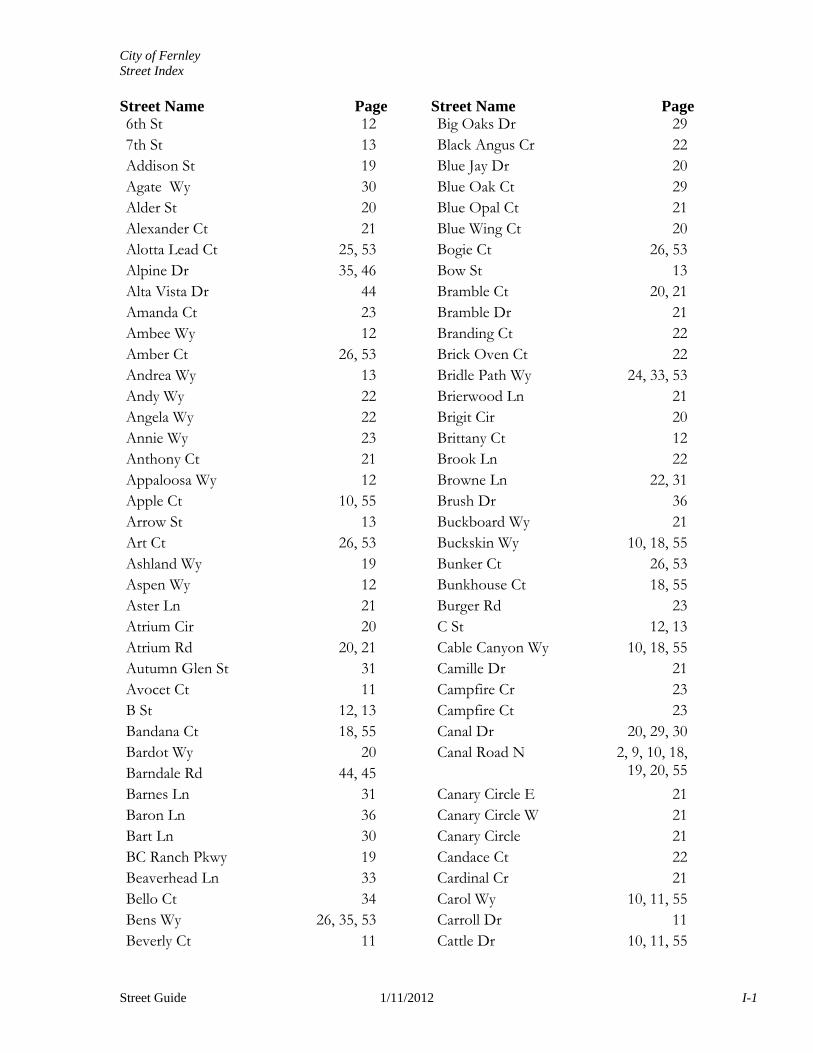
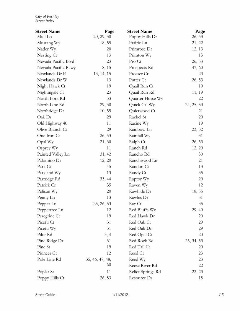
City of Fernley Street Index Street Name Page Street Name Page Street Guide 1/11/2012 I-1 6th St 12 7th St 13 Addison St 19 Agate Wy 30 Alder St 20 Alexander Ct 21 Alotta Lead Ct 25, 53 Alpine Dr 35, 46 Alta Vista Dr 44 Amanda Ct 23 Ambee Wy 12 Amber Ct 26, 53 Andrea Wy 13 Andy Wy 22 Angela Wy 22 Annie Wy 23 Anthony Ct 21 Appaloosa Wy 12 Apple Ct 10, 55 Arrow St 13 Art Ct 26, 53 Ashland Wy 19 Aspen Wy 12 Aster Ln 21 Atrium Cir 20 Atrium Rd 20, 21 Autumn Glen St 31 Avocet Ct 11 B St 12, 13 Bandana Ct 18, 55 Bardot Wy 20 Barndale Rd 44, 45 Barnes Ln 31 Baron Ln 36 Bart Ln 30 BC Ranch Pkwy 19 Beaverhead Ln 33 Bello Ct 34 Bens Wy 26, 35, 53 Beverly Ct 11 Big Oaks Dr 29 Black Angus Cr 22 Blue Jay Dr 20 Blue Oak Ct 29 Blue Opal Ct 21 Blue Wing Ct 20 Bogie Ct 26, 53 Bow St 13 Bramble Ct 20, 21 Bramble Dr 21 Branding Ct 22 Brick Oven Ct 22 Bridle Path Wy 24, 33, 53 Brierwood Ln 21 Brigit Cir 20 Brittany Ct 12 Brook Ln 22 Browne Ln 22, 31 Brush Dr 36 Buckboard Wy 21 Buckskin Wy 10, 18, 55 Bunker Ct 26, 53 Bunkhouse Ct 18, 55 Burger Rd 23 C St 12, 13 Cable Canyon Wy 10, 18, 55 Camille Dr 21 Campfire Cr 23 Campfire Ct 23 Canal Dr 20, 29, 30 Canal Road N 2, 9, 10, 18, 19, 20, 55 Canary Circle E 21 Canary Circle W 21 Canary Circle 21 Candace Ct 22 Cardinal Cr 21 Carol Wy 10, 11, 55 Carroll Dr 11 Cattle Dr 10, 11, 55
Transcript of Street Guide Interior - City of Fernley
City of Fernley Street Index Street Name Page Street Name Page
Street Guide 1/11/2012 I-1
6th St 127th St 13Addison St 19Agate Wy 30Alder St 20Alexander Ct 21Alotta Lead Ct 25, 53Alpine Dr 35, 46Alta Vista Dr 44Amanda Ct 23Ambee Wy 12Amber Ct 26, 53Andrea Wy 13Andy Wy 22Angela Wy 22Annie Wy 23Anthony Ct 21Appaloosa Wy 12Apple Ct 10, 55Arrow St 13Art Ct 26, 53Ashland Wy 19Aspen Wy 12Aster Ln 21Atrium Cir 20Atrium Rd 20, 21Autumn Glen St 31Avocet Ct 11B St 12, 13Bandana Ct 18, 55Bardot Wy 20Barndale Rd 44, 45Barnes Ln 31Baron Ln 36Bart Ln 30BC Ranch Pkwy 19Beaverhead Ln 33Bello Ct 34Bens Wy 26, 35, 53Beverly Ct 11
Big Oaks Dr 29Black Angus Cr 22Blue Jay Dr 20Blue Oak Ct 29Blue Opal Ct 21Blue Wing Ct 20Bogie Ct 26, 53Bow St 13Bramble Ct 20, 21Bramble Dr 21Branding Ct 22Brick Oven Ct 22Bridle Path Wy 24, 33, 53Brierwood Ln 21Brigit Cir 20Brittany Ct 12Brook Ln 22Browne Ln 22, 31Brush Dr 36Buckboard Wy 21Buckskin Wy 10, 18, 55Bunker Ct 26, 53Bunkhouse Ct 18, 55Burger Rd 23C St 12, 13Cable Canyon Wy 10, 18, 55Camille Dr 21Campfire Cr 23Campfire Ct 23Canal Dr 20, 29, 30Canal Road N 2, 9, 10, 18,
19, 20, 55
Canary Circle E 21Canary Circle W 21Canary Circle 21Candace Ct 22Cardinal Cr 21Carol Wy 10, 11, 55Carroll Dr 11Cattle Dr 10, 11, 55
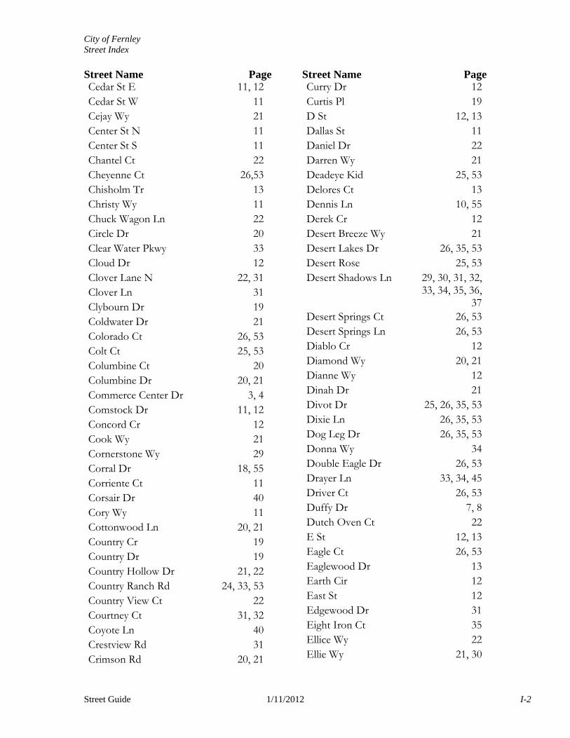
City of Fernley Street Index Street Name Page Street Name Page
Street Guide 1/11/2012 I-2
Cedar St E 11, 12Cedar St W 11Cejay Wy 21Center St N 11Center St S 11Chantel Ct 22Cheyenne Ct 26,53Chisholm Tr 13Christy Wy 11Chuck Wagon Ln 22Circle Dr 20Clear Water Pkwy 33Cloud Dr 12Clover Lane N 22, 31Clover Ln 31Clybourn Dr 19Coldwater Dr 21Colorado Ct 26, 53Colt Ct 25, 53Columbine Ct 20Columbine Dr 20, 21Commerce Center Dr 3, 4Comstock Dr 11, 12Concord Cr 12Cook Wy 21Cornerstone Wy 29Corral Dr 18, 55Corriente Ct 11Corsair Dr 40Cory Wy 11Cottonwood Ln 20, 21Country Cr 19Country Dr 19Country Hollow Dr 21, 22Country Ranch Rd 24, 33, 53Country View Ct 22Courtney Ct 31, 32Coyote Ln 40Crestview Rd 31Crimson Rd 20, 21
Curry Dr 12Curtis Pl 19D St 12, 13Dallas St 11Daniel Dr 22Darren Wy 21Deadeye Kid 25, 53Delores Ct 13Dennis Ln 10, 55Derek Cr 12Desert Breeze Wy 21Desert Lakes Dr 26, 35, 53Desert Rose 25, 53Desert Shadows Ln 29, 30, 31, 32,
33, 34, 35, 36, 37
Desert Springs Ct 26, 53Desert Springs Ln 26, 53Diablo Cr 12Diamond Wy 20, 21Dianne Wy 12Dinah Dr 21Divot Dr 25, 26, 35, 53Dixie Ln 26, 35, 53Dog Leg Dr 26, 35, 53Donna Wy 34Double Eagle Dr 26, 53Drayer Ln 33, 34, 45Driver Ct 26, 53Duffy Dr 7, 8Dutch Oven Ct 22E St 12, 13Eagle Ct 26, 53Eaglewood Dr 13Earth Cir 12East St 12Edgewood Dr 31Eight Iron Ct 35Ellice Wy 22Ellie Wy 21, 30
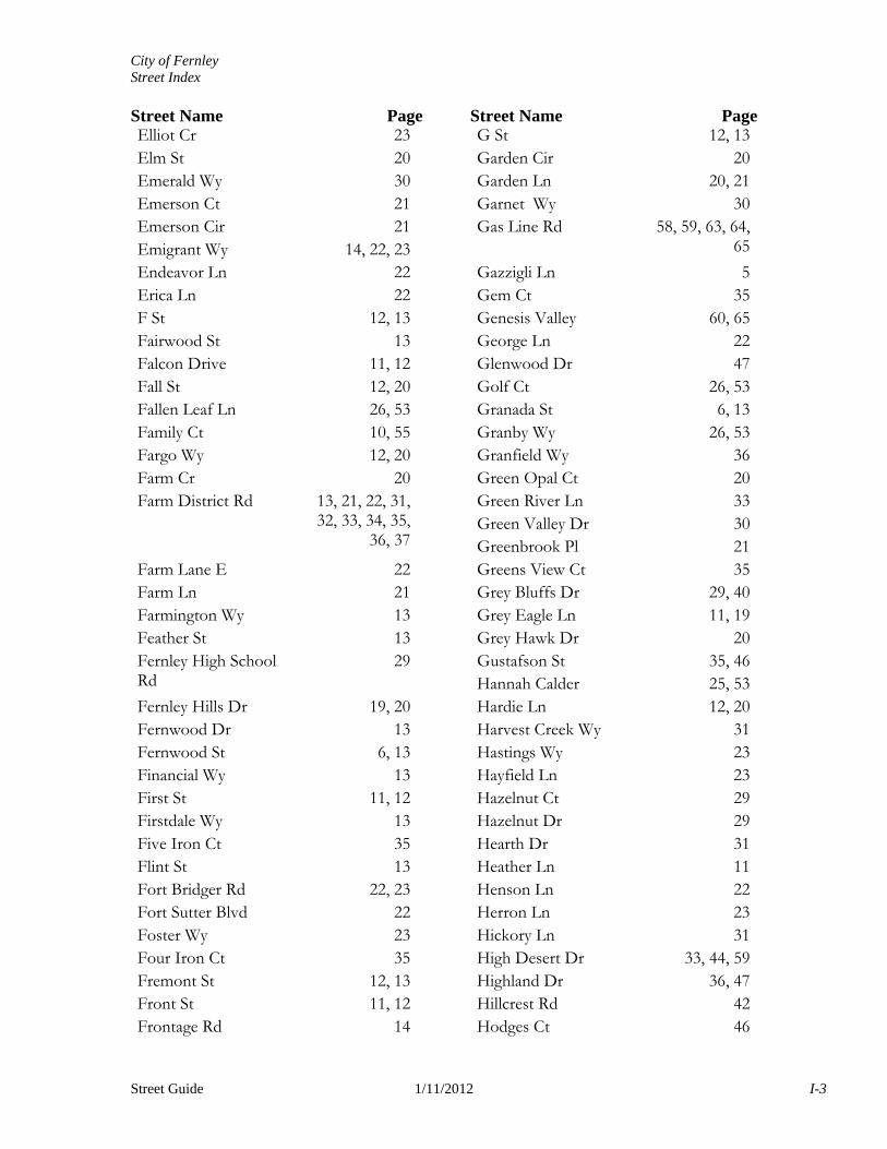
City of Fernley Street Index Street Name Page Street Name Page
Street Guide 1/11/2012 I-3
Elliot Cr 23Elm St 20Emerald Wy 30Emerson Ct 21Emerson Cir 21Emigrant Wy 14, 22, 23Endeavor Ln 22Erica Ln 22F St 12, 13Fairwood St 13Falcon Drive 11, 12Fall St 12, 20Fallen Leaf Ln 26, 53Family Ct 10, 55Fargo Wy 12, 20Farm Cr 20Farm District Rd 13, 21, 22, 31,
32, 33, 34, 35, 36, 37
Farm Lane E 22Farm Ln 21Farmington Wy 13Feather St 13Fernley High School Rd
29
Fernley Hills Dr 19, 20Fernwood Dr 13Fernwood St 6, 13Financial Wy 13First St 11, 12Firstdale Wy 13Five Iron Ct 35Flint St 13Fort Bridger Rd 22, 23Fort Sutter Blvd 22Foster Wy 23Four Iron Ct 35Fremont St 12, 13Front St 11, 12Frontage Rd 14
G St 12, 13Garden Cir 20Garden Ln 20, 21Garnet Wy 30Gas Line Rd 58, 59, 63, 64,
65
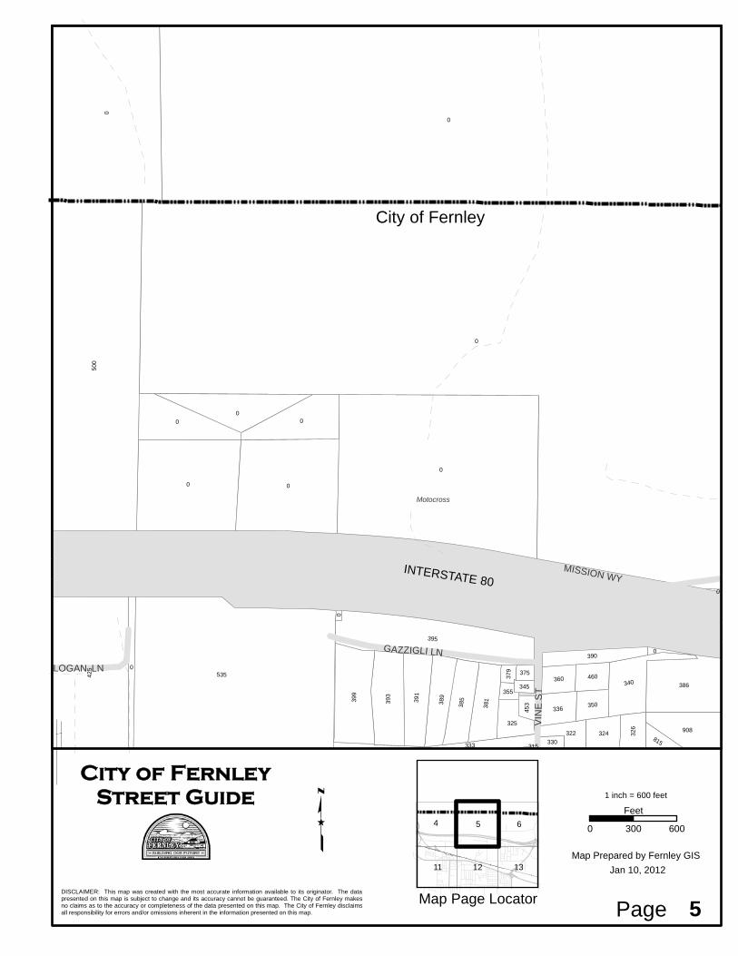
Gazzigli Ln 5Gem Ct 35Genesis Valley 60, 65George Ln 22Glenwood Dr 47Golf Ct 26, 53Granada St 6, 13Granby Wy 26, 53Granfield Wy 36Green Opal Ct 20Green River Ln 33Green Valley Dr 30Greenbrook Pl 21Greens View Ct 35Grey Bluffs Dr 29, 40Grey Eagle Ln 11, 19Grey Hawk Dr 20Gustafson St 35, 46Hannah Calder 25, 53Hardie Ln 12, 20Harvest Creek Wy 31Hastings Wy 23Hayfield Ln 23Hazelnut Ct 29Hazelnut Dr 29Hearth Dr 31Heather Ln 11Henson Ln 22Herron Ln 23Hickory Ln 31High Desert Dr 33, 44, 59Highland Dr 36, 47Hillcrest Rd 42Hodges Ct 46
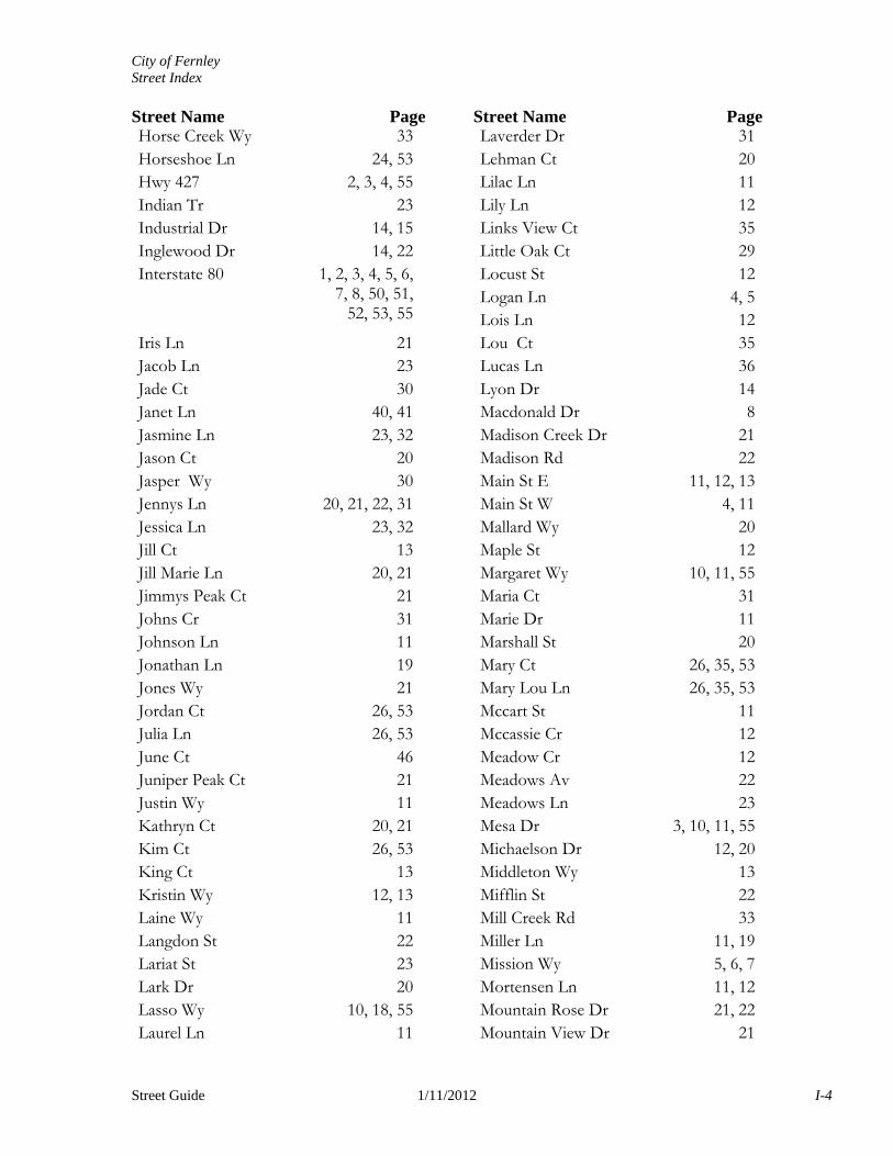
City of Fernley Street Index Street Name Page Street Name Page
Street Guide 1/11/2012 I-4
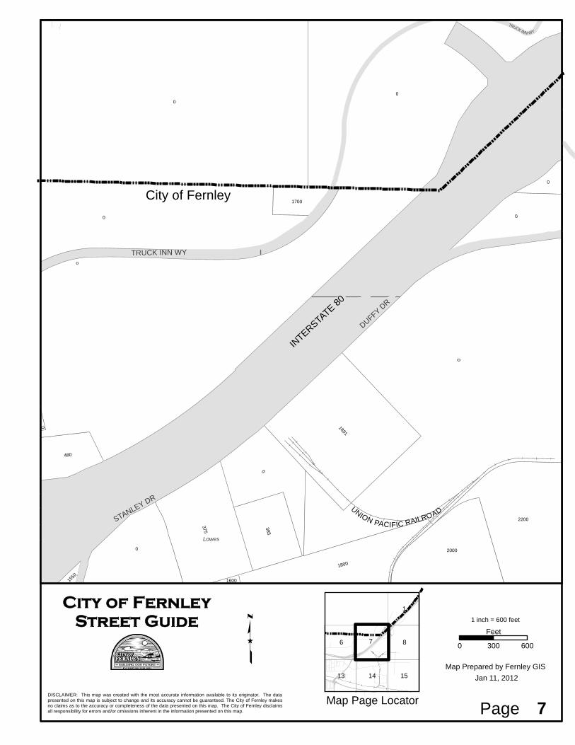
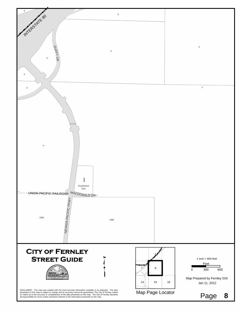
Horse Creek Wy 33Horseshoe Ln 24, 53Hwy 427 2, 3, 4, 55Indian Tr 23Industrial Dr 14, 15Inglewood Dr 14, 22Interstate 80 1, 2, 3, 4, 5, 6,
7, 8, 50, 51, 52, 53, 55
Iris Ln 21Jacob Ln 23Jade Ct 30Janet Ln 40, 41Jasmine Ln 23, 32Jason Ct 20Jasper Wy 30Jennys Ln 20, 21, 22, 31Jessica Ln 23, 32Jill Ct 13Jill Marie Ln 20, 21Jimmys Peak Ct 21Johns Cr 31Johnson Ln 11Jonathan Ln 19Jones Wy 21Jordan Ct 26, 53Julia Ln 26, 53June Ct 46Juniper Peak Ct 21Justin Wy 11Kathryn Ct 20, 21Kim Ct 26, 53King Ct 13Kristin Wy 12, 13Laine Wy 11Langdon St 22Lariat St 23Lark Dr 20Lasso Wy 10, 18, 55Laurel Ln 11
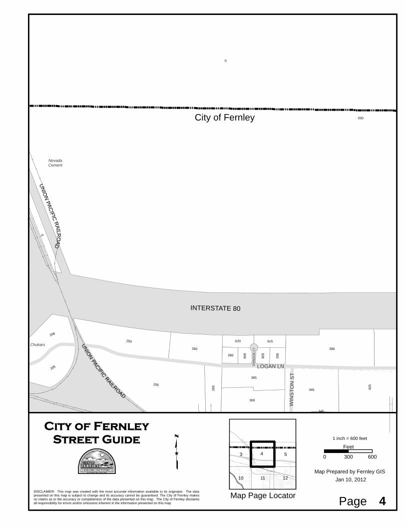
Laverder Dr 31Lehman Ct 20Lilac Ln 11Lily Ln 12Links View Ct 35Little Oak Ct 29Locust St 12Logan Ln 4, 5Lois Ln 12Lou Ct 35Lucas Ln 36Lyon Dr 14Macdonald Dr 8Madison Creek Dr 21Madison Rd 22Main St E 11, 12, 13Main St W 4, 11Mallard Wy 20Maple St 12Margaret Wy 10, 11, 55Maria Ct 31Marie Dr 11Marshall St 20Mary Ct 26, 35, 53Mary Lou Ln 26, 35, 53Mccart St 11Mccassie Cr 12Meadow Cr 12Meadows Av 22Meadows Ln 23Mesa Dr 3, 10, 11, 55Michaelson Dr 12, 20Middleton Wy 13Mifflin St 22Mill Creek Rd 33Miller Ln 11, 19Mission Wy 5, 6, 7Mortensen Ln 11, 12Mountain Rose Dr 21, 22Mountain View Dr 21
City of Fernley Street Index Street Name Page Street Name Page
Street Guide 1/11/2012 I-5
Mull Ln 20, 29, 30Mustang Wy 18, 55Nader Wy 20Nesting Ct 13Nevada Pacific Blvd 23Nevada Pacific Pkwy 8, 15Newlands Dr E 13, 14, 15Newlands Dr W 13Night Hawk Ct 19Nightingale Ct 23North Fork Rd 33North Line Rd 29, 30Northridge Dr 10, 55Oak Dr 29Old Highway 40 11Olive Branch Ct 29One Iron Ct 26, 53Opal Wy 21, 30Osprey Wy 11Painted Valley Ln 31, 42Palomino Dr 12, 20Park Ct 45Parkland Wy 13Partridge Rd 33, 44Patrick Cr 35Pelican Wy 20Penny Ln 13Pepper Ln 25, 26, 53Peppertree Ln 12Peregrine Ct 19Picetti Ct 31Picetti Wy 31Pilot Rd 3, 4Pine Ridge Dr 31Pine St 19Pioneer Ct 12Pole Line Rd 35, 46, 47, 48,
60
Poplar St 11Poppy Hills Ct 26, 53
Poppy Hills Dr 26, 53Prairie Ln 21, 22Primrose Dr 12, 13Primton Wy 13Pro Ct 26, 53Prospects Rd 47, 60Prosser Cr 23Putter Ct 26, 53Quail Run Ct 19Quail Run Rd 11, 19Quarter Horse Wy 22Quick Cal Wy 24, 25, 53Quietwood Ct 21Rachel St 20Racine Wy 19Rainbow Ln 23, 32Rainfall Wy 31Ralph Ct 26, 53Ranch Rd 12, 20Rancho Rd 30Ranchwood Ln 21Randon Ct 13Randy Ct 35Raptor Wy 20Raven Wy 12Rawhide Dr 18, 55Rawles Dr 31Ray Ct 35Red Bluffs Wy 29, 40Red Hawk Dr 20Red Oak Ct 29Red Oak Dr 29Red Opal Ct 20Red Rock Rd 25, 34, 53Red Tail Ct 20Reed Cr 23Reed Wy 23Reese River Rd 22Relief Springs Rd 22, 23Resource Dr 15
City of Fernley Street Index Street Name Page Street Name Page
Street Guide 1/11/2012 I-6
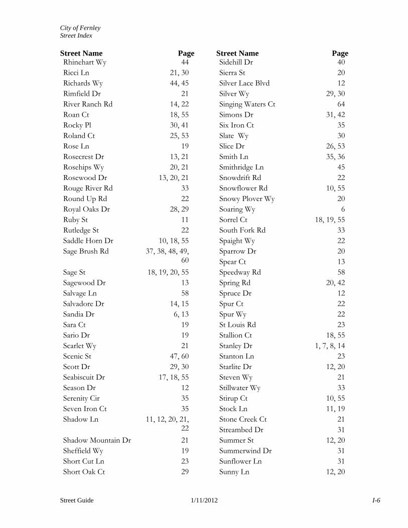
Rhinehart Wy 44Ricci Ln 21, 30Richards Wy 44, 45Rimfield Dr 21River Ranch Rd 14, 22Roan Ct 18, 55Rocky Pl 30, 41Roland Ct 25, 53Rose Ln 19Rosecrest Dr 13, 21Rosehips Wy 20, 21Rosewood Dr 13, 20, 21Rouge River Rd 33Round Up Rd 22Royal Oaks Dr 28, 29Ruby St 11Rutledge St 22Saddle Horn Dr 10, 18, 55Sage Brush Rd 37, 38, 48, 49,
60
Sage St 18, 19, 20, 55Sagewood Dr 13Salvage Ln 58Salvadore Dr 14, 15Sandia Dr 6, 13Sara Ct 19Sario Dr 19Scarlet Wy 21Scenic St 47, 60Scott Dr 29, 30Seabiscuit Dr 17, 18, 55Season Dr 12Serenity Cir 35Seven Iron Ct 35Shadow Ln 11, 12, 20, 21,
22
Shadow Mountain Dr 21Sheffield Wy 19Short Cut Ln 23Short Oak Ct 29
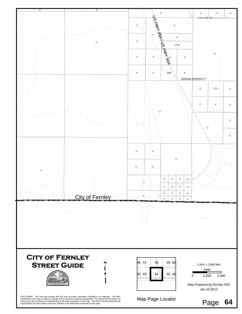
Sidehill Dr 40Sierra St 20Silver Lace Blvd 12Silver Wy 29, 30Singing Waters Ct 64Simons Dr 31, 42Six Iron Ct 35Slate Wy 30Slice Dr 26, 53Smith Ln 35, 36Smithridge Ln 45Snowdrift Rd 22Snowflower Rd 10, 55Snowy Plover Wy 20Soaring Wy 6Sorrel Ct 18, 19, 55South Fork Rd 33Spaight Wy 22Sparrow Dr 20Spear Ct 13Speedway Rd 58Spring Rd 20, 42Spruce Dr 12Spur Ct 22Spur Wy 22St Louis Rd 23Stallion Ct 18, 55Stanley Dr 1, 7, 8, 14Stanton Ln 23Starlite Dr 12, 20Steven Wy 21Stillwater Wy 33Stirup Ct 10, 55Stock Ln 11, 19Stone Creek Ct 21Streambed Dr 31Summer St 12, 20Summerwind Dr 31Sunflower Ln 31Sunny Ln 12, 20
City of Fernley Street Index Street Name Page Street Name Page
Street Guide 1/11/2012 I-7
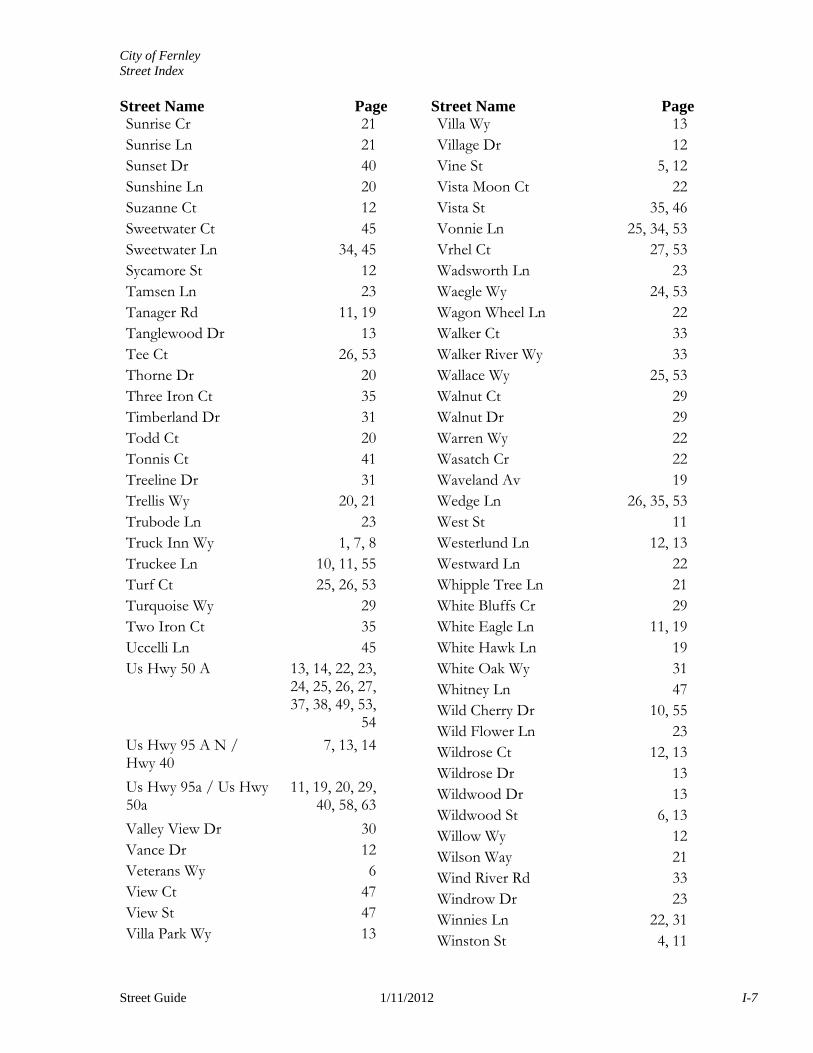
Sunrise Cr 21Sunrise Ln 21Sunset Dr 40Sunshine Ln 20Suzanne Ct 12Sweetwater Ct 45Sweetwater Ln 34, 45Sycamore St 12Tamsen Ln 23Tanager Rd 11, 19Tanglewood Dr 13Tee Ct 26, 53Thorne Dr 20Three Iron Ct 35Timberland Dr 31Todd Ct 20Tonnis Ct 41Treeline Dr 31Trellis Wy 20, 21Trubode Ln 23Truck Inn Wy 1, 7, 8Truckee Ln 10, 11, 55Turf Ct 25, 26, 53Turquoise Wy 29Two Iron Ct 35Uccelli Ln 45Us Hwy 50 A 13, 14, 22, 23,
24, 25, 26, 27, 37, 38, 49, 53,
54
Us Hwy 95 A N / Hwy 40
7, 13, 14
Us Hwy 95a / Us Hwy 50a
11, 19, 20, 29, 40, 58, 63
Valley View Dr 30Vance Dr 12Veterans Wy 6View Ct 47View St 47Villa Park Wy 13
Villa Wy 13Village Dr 12Vine St 5, 12Vista Moon Ct 22Vista St 35, 46Vonnie Ln 25, 34, 53Vrhel Ct 27, 53Wadsworth Ln 23Waegle Wy 24, 53Wagon Wheel Ln 22Walker Ct 33Walker River Wy 33Wallace Wy 25, 53Walnut Ct 29Walnut Dr 29Warren Wy 22Wasatch Cr 22Waveland Av 19Wedge Ln 26, 35, 53West St 11Westerlund Ln 12, 13Westward Ln 22Whipple Tree Ln 21White Bluffs Cr 29White Eagle Ln 11, 19White Hawk Ln 19White Oak Wy 31Whitney Ln 47Wild Cherry Dr 10, 55Wild Flower Ln 23Wildrose Ct 12, 13Wildrose Dr 13Wildwood Dr 13Wildwood St 6, 13Willow Wy 12Wilson Way 21Wind River Rd 33Windrow Dr 23Winnies Ln 22, 31Winston St 4, 11
City of Fernley Street Index Street Name Page Street Name Page
Street Guide 1/11/2012 I-8
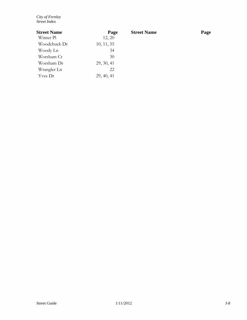
Winter Pl 12, 20Woodchuck Dr 10, 11, 55Woody Ln 34Worsham Ct 30Worsham Dr 29, 30, 41Wrangler Ln 22Yves Dr 29, 40, 41
City of Fernley
290
620 615
280
600
605
0
255
265
300
365
205
250
206
425
390260
500
0
345
345
UN
ION
PAC
IFIC
RA
ILRO
AD
UN
ION
PACIFIC
RAILROAD
Chukars
NevadaCement
SH
I NO
OK
CT
WIN
ST
ON
ST
LOGAN LN
INTERSTATE 80
1 inch = 600 feet
0 600300
Feet
Map Page LocatorDISCLAIMER: This map was created with the most accurate information available to its originator. The datapresented on this map is subject to change and its accuracy cannot be guaranteed. The City of Fernley makesno claims as to the accuracy or completeness of the data presented on this map. The City of Fernley disclaimsall responsibility for errors and/or omissions inherent in the information presented on this map.
City of FernleyStreet Guide
Map Prepared by Fernley GISs
Page
3 4 5
10 11 12 Jan 10, 2012
4
City of Fernley
333
0
0
0535
336
355
324908
325
453
379
815
322
360
381
330
0
0 0
345
425
0
0
395
460
385
386
389
391
340
393
0390
399
326
0
500
350
00
0
315
375
Motocross
VIN
E S
T
LOGAN LN
GAZZIGLI LN
MISSION WYINTERSTATE 80
1 inch = 600 feet
0 600300
Feet
Map Page LocatorDISCLAIMER: This map was created with the most accurate information available to its originator. The datapresented on this map is subject to change and its accuracy cannot be guaranteed. The City of Fernley makesno claims as to the accuracy or completeness of the data presented on this map. The City of Fernley disclaimsall responsibility for errors and/or omissions inherent in the information presented on this map.
City of FernleyStreet Guide
Map Prepared by Fernley GISs
Page
4 5 6
11 12 13 Jan 10, 2012
5
City of Fernley0
0
0
0
480
2000
375
0
1800
1550
385
2200
1891
0
0
1600
1700
0
0
0
UNION PACIFIC RAILROAD
Lowes
TRUCK INN WY
STANLEY DR
DUFFY DR
TRUCK INN WY
INTERSTA
TE 80
1 inch = 600 feet
0 600300
Feet
Map Page LocatorDISCLAIMER: This map was created with the most accurate information available to its originator. The datapresented on this map is subject to change and its accuracy cannot be guaranteed. The City of Fernley makesno claims as to the accuracy or completeness of the data presented on this map. The City of Fernley disclaimsall responsibility for errors and/or omissions inherent in the information presented on this map.
City of FernleyStreet Guide
Map Prepared by Fernley GISs
Page
1
6 7 8
13 14 15 Jan 11, 2012
7
0
0
0
0
0
0
0
23002200
0
590
0
0
UNION PACIFIC RAILROAD
SouthwestGas
MACDONALD DR
NE
VA
DA
PA
CIF
IC P
KW
Y
DU
FF
Y D
R
INTERSTA
TE 80
1 inch = 600 feet
0 600300
Feet
Map Page LocatorDISCLAIMER: This map was created with the most accurate information available to its originator. The datapresented on this map is subject to change and its accuracy cannot be guaranteed. The City of Fernley makesno claims as to the accuracy or completeness of the data presented on this map. The City of Fernley disclaimsall responsibility for errors and/or omissions inherent in the information presented on this map.
City of FernleyStreet Guide
Map Prepared by Fernley GISs
Page
1
7 8
14 15 16 Jan 11, 2012
8
US
Hw
y 9
5A
/ U
S H
wy
50A
150
0
140
130
110120
0
0 245
0 0
192
186
150
150
150
450
495494
491
493
497
499498
496
487
485
489
209
217
213
318
314
310
241
342
338
237
233
334
330
229
225
326
322
221
210
481
483242
238
234
230
226
222
218
214
470
415
460
600
75
0
600
610
615604 621
560
574
564
525
0
530505
515 540
550525
535
571 556
548
546
544
542
570
580
611
601
591
541
480
255
265
594584
524543
545
547
549
551
553555557590
555
565
585
554
544
534
545
514
504 531
541
551
561
0
115
62
8411 301306 727 726203 640
625 7280
63
06
32
63
4
595
600
63
6
633
732
396
63
8
736737
565 580
575
208
214
2 00
215408 202
204
570
206
407
605
610
545
550
525
540
64
055
729
731
724665
635
637
288
286284743806040
301
20
627630
480
629
739
401
735
741
515
360
370
345
3550
33
405
475
320
395
360
130
150
355
3 60
230
250
270
310
330
350
230
641
250
145
135
125
315
335
218
303
240
115
857565453565320
145
340360
160
45
330
115352515250230235230
145190
200325345365 130200
60
17
5270290275
355
210
165
190215 225 1557060
220 175140
125
85
150
155
65 7268
350
175
2545
94
7355452595115
325 13
5
155
165225
200180150
13011
0
600
504030
45
290
150
10170
30
0
10
908045
75
1851451058575
282
670655
540 639738
64
2
90
7098
410
550
20
20
25
140
180
6040
260255250170
165130150
240
270
5090
2035
380
320
195
215
235
255
275
315
335
355
250
55
140
8545
12050403020 21
0170
110
409
213
255
275
6555
420
135210
150
0
360 180
603020220
0
420
150
60
100
60
70
75
65
,7
5A
75
B
95
0
550
210250
410
403
235
165
65
4055
310
25
55
300
425
302540
305
65
35760
400
135
155
155165
235
255
265
275
300
55
580
75
90
8070
0
6010
275 35
260
270
280
50
250
260
400
45
125
180
0
435
250
260
320340
770
70 45590
45
100
325215
90
225
570
80
725
734
345
600
25
345
55
0
120
120
100
80
50
0
635
733
535
400
302
50
125
30
415
500
510
270
160
530
35
80 185
125 170
250
285
292
290
631
440
415415415415
405
315
325
415 415 415
415 415
415
UNION PACIFIC RAILROAD
UNION PACIFIC RAILROAD
In TownPark
MethodistChurch
LDSChurch
Community Church
LOC
US
T S
T
CLOUD DR SEASON DR
CARROLL DR
PO
PLA
R S
T
LIL
AC
LN
JOHNSON LN
FIRST ST
CH
RIS
TY
WY
BEVERLY CT
TAN
AG
ER
RD
FALCON DR
SU
NN
Y L
N
FA
LL
ST
WI N
TE
R P
L
WIN
ST
ON
ST
LAUREL LN
HEATHER LN
OS PR
EY
WY
WH
ITE
EA
GLE
LN
TRUCKEE LN
FIRST ST
MORTENSEN LN
JUSTIN WYLAINE WY
CORY WY
CEDAR ST E
COMSTOCK DR
MA
RIE
DR
MCCART ST
CEDAR ST W
CE
NT
ER
ST
S
QU
AIL
RUN RD
WE
ST
ST
SHADOW LN
MIL
LE
R L
N
EA
ST
ST
STA
RL
ITE
DR
CE
NT
ER
ST
N
RUBY ST
GR
EY
EA
GLE
LN
DA
LL
AS
ST
FRONT ST
PEREGRINE CT
AVOCET CT
OLD HIGHWAY 40
E MAIN ST
US
HW
Y 9
5A
/ U
S H
WY
50
A
W MAIN ST
1 inch = 600 feet
0 600300
Feet
Map Page LocatorDISCLAIMER: This map was created with the most accurate information available to its originator. The datapresented on this map is subject to change and its accuracy cannot be guaranteed. The City of Fernley makesno claims as to the accuracy or completeness of the data presented on this map. The City of Fernley disclaimsall responsibility for errors and/or omissions inherent in the information presented on this map.
City of FernleyStreet Guide
Map Prepared by Fernley GISs
Page
3 4 5
10 11 12
18 19 20 Jan 10, 2012
11
0
0
1190
1395
1405
1200121
0170
1201
150
1343
538 540
1310
1330 1360
1380 1480
0
130
1
920 960
108
0
144
1000
1
150
565146
103
5
102
510
15
100
5
497
440106010501030
865
950920
980
420430425
1
140
451 410412
360
365
540
13813
6
390395
330325347
260
250
191
24022
0210
200165
400
270
320
305
300894 295
1450
142
575
108
5
107
510
65
105
5
1010990
243
154
980970
104
5
175
190
148
875 136
5135
201 355910
220
0
200 202
230
200
1280
1245
105
5
935
104
5
999
925
98597
5
425
855
889
205 209206 208
0
269
895
20213
275
210
405
150
5
217
905
79
425
1500
45
1440
1420 1460
221224821
880
817
870
1375
813
860
805
801
820
1050
25 25
375
147
5
903214
280
12023
0227
240116011
50
280
130 245130
705703701 140231
0
294140 255
250
702
700
1400
284704229
1400
255145 145
291
298260265
260
265260
302
26510
270
223 55 115
5
117
5
113
5
112
5
415
280
1375
111
565228
824
240
955
107
5
106
5
232 60135245
290
30
25225
285280210
1380
25 1261
1255
274103
305235261
900
9 04
15
1350
1249
280
1270 38531
0240240 245 380
263 1264110
1252304 250 255 32
0
1340
266 12401210306
395
1254155107 1230268 1220269 260 260
308265
219
330106
40
908
315
270
155
0
1170102 245
249
101
5
975
0
816
808228
906
1267215
30
2901145290220
255
405400401
230230
267
325
896
275270
145
5
152
5
290295225 295
0
225
1320
250
410
139
201
97430
10
1241
1235
250255250
309
275
220
122
512
15
890
280285
305
103
405
1330
1256
222
908
906
904
308299
110
20
216 20
225
217
311
269
1281
125
709707
105
150 295
127528
5 335
109
111
1200
477
1260
1258
265
226
230708
706
360
105
107
235
218 35 35
139
5
1250
112 104106108
370
910
275
15520
234
152
875
350
15
120
5
111
5
108
5
945
370
900
120
270165
160
217
395
321
113891
925
945
935
27590
2
995155
115
5
885
995
985
975
965
955
945
935
925
915
905
1030
105
5
103
5
380
365
385380385399
375373
0 0
0
0
0
0UNION PACIFIC RAILROAD
Out of TownPark
Walmart
Fairgrounds
Post Office
Urgent Care
DELORES CT
FREMONT ST
FE
RN
WO
OD
ST
FINANCIAL WY
WIL
DW
OO
D S
T
JILL
CT
BOW ST
FEATHER STK
ING
CT
SP
EA
R C
T
SAGEWOOD DR
FAIRWOOD ST
RA
ND
ON
CT
TANGLEWOOD DR
AN
DR
EA
WY
ING
LE
WO
OD
DR
PE
N
N Y LN
WESTERLUND LN
FIR
ST
DA
LE
WY
MI D
DL
ET
ON
WY
VILLA WY
FA
RM
ING
TO
N W
Y
PR
IMT
ON
WY
NEWLANDS DR E
CH
ISH
OL
M T
R
7T
H S
T
FLINT ST
GR
AN
AD
A S
T
AR
RO
W S
T
NEWLANDS DR W
FREMONT ST
FE
RN
WO
OD
DR
WI L
DW
OO
D D
R
SA
ND
I A D
R
VIL
LA
PA
RK
WY
PARKLAND
WY
F ST
E ST
D ST
ST
B ST
NESTING CT
EAGLEWOOD DR
E MAIN ST
FA
RM
DIS
TR
ICT
RD US HWY 50A
US HW
Y 95A
N /
HWY 4
0
1 inch = 600 feet
0 600300
Feet
Map Page LocatorDISCLAIMER: This map was created with the most accurate information available to its originator. The datapresented on this map is subject to change and its accuracy cannot be guaranteed. The City of Fernley makesno claims as to the accuracy or completeness of the data presented on this map. The City of Fernley disclaimsall responsibility for errors and/or omissions inherent in the information presented on this map.
City of FernleyStreet Guide
Map Prepared by Fernley GISs
Page
5 6 7
12 13 14
20 21 22 Jan 10, 2012
13
0 0
0
766
768770
0
0 0
0 0
0
0
0
12000
2270
2217
0
1264
221022
08
220
0
220
2
220
6
220
4
12661176
1268
2212
2246
117
8
220
1
220
3
22051276
2214
2207 1179
22161272
2209
221
0
222
0
223
0
2218
22111274
1181
2222
2224
2247
224
9
2226
222
8
2215 1183
229
1
229
51290
229
9
11931292
119412941195
1196
2262
1278
220
5
222
5
221
5
22661280 1185
1282 2219
2274
1187
2278
225
1
225
5
225
91284
2263
2221
2282
2267
222
5
2275
22791288
2283 1191
2287
1296
11971198
2290
229
4
118
622
98
2271 11891286
2220
203522
131276
2245
129
8
2223
2286
0
0
1177
119
9
1529
1527
1525
1523
1521
1515
1507
1505
1503
1519
1513
1511
1509
1517
1205 2460
210
0
230
0
1170
1185
1140
1100
1200
622
624
62673
0
732
734
736
752
764
995
615 611
753 609
836
544
761 991
714
716
718
720
702
708
710
712
1055
950
955
730 938829
2150
101561
0
612
614 604616
618
620
736
540729
749 607
751 830
757
759
940735
1155
1220 1119 1017
835
5391118 937
9901020
1115
543
1258
706
609613 5371322 718
10141217 717978
1321 1216
1320 615
5421326
617
712811
611723
6071257
608
1113 1011706
1006
205
10191222
613 541
11081107
9321255
1318
738
740
742
526
632
634
6381309
936
12131253
1214
927
6261208
628
211
6301314
219 20
21410
7101307
204
229
2311308
714
208
716
235
720
11111212
100512091311
823
223
622
8241218
81212541319
724
60272
6
728
606
1013 8181115 9831114
970
600
604
975
7249821259
1256
1109
722
1120
534
60261
4
61612101211 1007 62
4
1030
5328061009
20721
51105
1408
214
724
1106
1207
712
605
610799
233
9861018
704
1251 1008
10121215 711974
708
1016
522
206
939
538
221
311
933536
744
746
748
750
10151117 98711161324
213
245728 309
2471406
249
722 9251306
1412
251 92325
9 129 516921
6061110 975
303
253
640
1010 805
620
7181409
120
5
21223
9
263271 265
1301
275 31
231
5
241
603934817
605
301130
255
935
2371305
232
520
971
242 514
244
246 126
304
248 1010
277
302
250
1006963
915 401955
128
270 121 913
6181416
201 528
754
1022
252
100
2
300
959
102628
2
2281404
705
1121
1112
227
756
758
760
512
1206
284
408
28628
8
619979
608 530
706
405
266
268
403122
278 951
704131014
11
132
1106
909116 504
910
1219
1114
114
273 261
269
410911 506
1312 636
210
966
274
906
1110 402
904939
1102
1407518
305
236
411
260
280 40
6947
510
238
2091414
1400 917
908
1118
123
313
1418
240 127
119
1252
200
225
254
919
513124
505
1091210
900
262
407
264
306
1501 125
726
243
118
257
256
103
107
1214
111
112
6
272 5081018
308
120
276
1122
1222
409
404117
943 115 907
101
4
1206
101
230
226
1202
122
6
203
931
3101402
524
901
1230
1218
0
927
0
502
500
102
131
3071303
258
935
113 503905 501112903
1035
1000
99
105
0
00
0
262
0
0
0
110
0
0
0
SilverlandMiddle School
F E R N L E Y W M A
JES
SIC
A LN
JES
SIC
A L
N
WIN
DROW
DR
ELL
IOT CIR
HA
STI
NG
S W
Y
WA
DS
WO
RT
H L
N
AMANDA CT
LARIAT ST
CA
MP
FIR
E C
IR
HAYFIELD LN
ST
LO
UIS
RD
NE
VA
DA
PACI
FIC BLV
D ANNIE WY
RA
INB
OW
LN
EMIGRANT WY
TAMSEN LN
EMIGRANT WY
STA
NTO
N LN
FO
ST
ER
WY
HE
RR
ON
LN
IND
IAN
TR
JAC
OB
LN
SH
OR
T C
UT
LNJA
SM
INE
LN
JASMINE LN
REED CIR
PROSSER CIR
REED WY
NIGHTINGALE CT
MEADOWS LN
WILD FLOWER LN
CAMPFIRE CT
ODE LN
FARM DISTRICT RD
US HWY 50A
1 inch = 600 feet
0 600300
Feet
Map Page LocatorDISCLAIMER: This map was created with the most accurate information available to its originator. The datapresented on this map is subject to change and its accuracy cannot be guaranteed. The City of Fernley makesno claims as to the accuracy or completeness of the data presented on this map. The City of Fernley disclaimsall responsibility for errors and/or omissions inherent in the information presented on this map.
City of FernleyStreet Guide
Map Prepared by Fernley GISs
Page
14 15 16
22 23 24
31 32 33 Jan 10, 2012
23
SA
LVA
GE
LN
SPEEDWAY RD
GAS LINE RD
US
HW
Y 95A
/ US
HW
Y 50A
695
0
0
30 0
0
45
00
0
0
00
0
000
000
4500
18
111055
0
0
0
0
0196
519
55
0
25
00
0
0
0
0
0
0
0
2000
0
0
0
00
26
17
0
0
0
54
0
0
5040
0
0
0
0
1 inch = 2,400 feet
0 2,4001,200
Feet
Map Page LocatorDISCLAIMER: This map was created with the most accurate information available to its originator. The datapresented on this map is subject to change and its accuracy cannot be guaranteed. The City of Fernley makes noclaims as to the accuracy or completeness of the data presented on this map. The City of Fernley disclaims allresponsibility for errors and/or omissions inherent in the information presented on this map.
City of FernleyStreet Guide
Map Prepared by Fernley GISs
Page
58 5957
6563
55
64
53
6056
6662
58
Jan 10 2012
City of Fernley
SINGING WATERS CT
GAS LINE RD
US
HW
Y 95A
/ US
HW
Y 50A
0
0
00
0
0
00
0
00
0
0
000
0000
0
0
00
0
0
0
00
000
0
001777
0
0
0
0
0
00
0
0
0
0
0
0
00
3720
0
39850
0
1 inch = 2,400 feet
0 2,4001,200
Feet
Map Page LocatorDISCLAIMER: This map was created with the most accurate information available to its originator. The datapresented on this map is subject to change and its accuracy cannot be guaranteed. The City of Fernley makes noclaims as to the accuracy or completeness of the data presented on this map. The City of Fernley disclaims allresponsibility for errors and/or omissions inherent in the information presented on this map.
City of FernleyStreet Guide
Map Prepared by Fernley GISs
Page
63 64 65
595857
6662
56 60
64
Jan 10 2012