Marlow, Oklahoma Stephens Countygeo.ou.edu/oeb/municipal/MARLOW.pdf · 9 h S t W Gilk ey Av Sisk Dr...
1
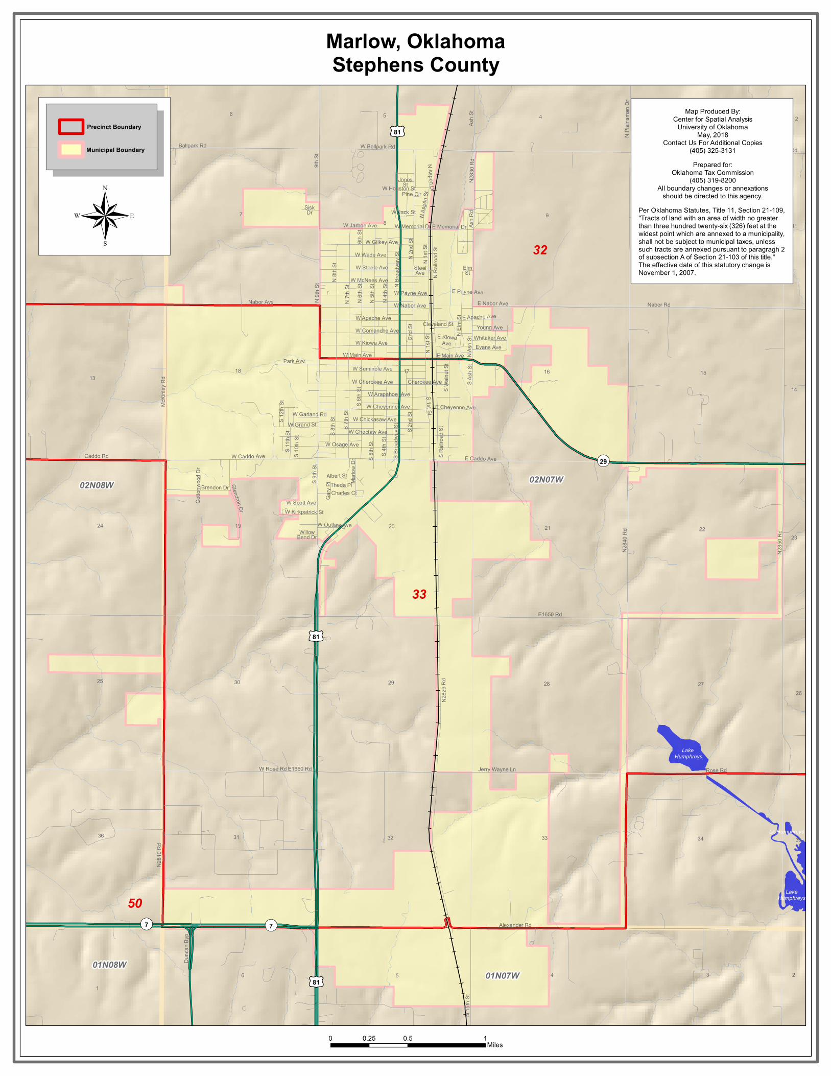
E1650 Rd Jerry Wayne Ln N 15th St Nabor Ave Ballpark Rd E Memorial Dr Ash Rd W Kirkpatrick St S Walnut St W Cheyenne Ave E1660 Rd W Comanche Ave W Grand St Steel Ave Elm St Alexander Rd N Railroad St Cherokee Ave Duncan Byp Goad Rd N Ash St Young Ave Gary Pl Rose Rd E Kiowa Ave S 11th St E Caddo Ave W Scott Ave S 1st St W Main Ave Pine Cir W Outlaw Ave McKinley Rd W McNees Ave N2810 Rd N2829 Rd Albert St Theda Pl N Aspen St N2830 Rd Charles Ct S 2nd St S 5th St S 4th St W Seminole Ave N 5th St S 7th St N 4th St 2nd St S 6th St N 2nd St S 8th St N 1st St Jones St Caddo Rd W Houston St N Aspen Dr W Jack St W Payne Ave N 9th St Evans Ave E Cheyenne Ave E Apache Ave E Nabor Ave E Payne Ave Whitaker Ave S Ash St W Apache Ave Park Ave S 10th St W Caddo Ave N 6th St W Kiowa Ave W Chickasaw Ave W Arapahoe Ave W Choctaw Ave N 7th St W Wade Ave W Steele Ave W Osage Ave W Jarboe Ave W Nabor Ave W Cherokee Ave N 8th St W Memorial Dr Cleveland St S Railroad St Nabor Rd Cottonwood Dr 6th St S 9th St W Gilkey Ave Sisk Dr N2850 Rd Marlow Dr W Rose Rd W Ballpark Rd S 12th St Willow Bend Dr W Garland Rd N2840 Rd N Elm St 9th St Brendon Dr Ash St Glendron Dr N Plainsman Dr ¬ « 29 ¬ « 7 ¬ « 7 £ ¤ 81 £ ¤ 81 £ ¤ 81 E Main Ave N Broadway St S Broadway St N 1st St 32 33 50 Lake Humphreys Lk Humphreys Lake Humphreys 01N07W 01N08W 02N07W 02N08W 2 3 4 5 6 1 2 4 5 6 7 8 9 11 14 15 16 17 18 19 20 21 22 23 26 27 28 29 30 31 32 33 34 35 13 24 25 36 Marlow, Oklahoma Stephens County 0 0.5 1 0.25 Miles Precinct Boundary Municipal Boundary ® Per Oklahoma Statutes, Title 11, Section 21-109, "Tracts of land with an area of width no greater than three hundred twenty-six (326) feet at the widest point which are annexed to a municipality, shall not be subject to municipal taxes, unless such tracts are annexed pursuant to paragragh 2 of subsection A of Section 21-103 of this title." The effective date of this statutory change is November 1, 2007. Map Produced By: Center for Spatial Analysis University of Oklahoma May, 2018 Contact Us For Additional Copies (405) 325-3131 Prepared for: Oklahoma Tax Commission (405) 319-8200 All boundary changes or annexations should be directed to this agency.
Transcript of Marlow, Oklahoma Stephens Countygeo.ou.edu/oeb/municipal/MARLOW.pdf · 9 h S t W Gilk ey Av Sisk Dr...
E1650 Rd
Jerry Wayne Ln
N 15
th St
Nabor Ave
Ballpark Rd
E Memorial Dr Ash R
d
W Kirkpatrick St
S Waln
ut St
W Cheyenne Ave
E1660 Rd
W Comanche Ave
W Grand St
SteelAve ElmSt
Alexander Rd
N Ra
ilroad
St
Cherokee Ave
Dunc
an By
p
Goad Rd
N Ash
St
Young AveGa
ry Pl
Rose Rd
E KiowaAve
S 11th
St
E Caddo Ave
W Scott Ave
S 1st St
W Main Ave
Pine Cir
W Outlaw Ave
McKin
ley R
d
W McNees Ave
N281
0 Rd
N282
9 Rd
Albert StTheda Pl
N Asp
en St
N283
0 Rd
Charles Ct
S 2nd
St
S 5th
StS 4
th St
W Seminole AveN
5th S
t
S 7th
St
N 4th
St
2nd S
t
S 6th
St
N 2n
d St
S 8th
St
N 1s
t St
JonesSt
Caddo Rd
W Houston St
N Aspen Dr
W Jack St
W Payne Ave
N 9th
St
Evans Ave
E Cheyenne Ave
E Apache Ave
E Nabor AveE Payne Ave
Whitaker Ave
S Ash
St
W Apache Ave
Park Ave
S 10th
St
W Caddo Ave
N 6th
St
W Kiowa Ave
W Chickasaw Ave
W Arapahoe Ave
W Choctaw Ave
N 7th
St
W Wade AveW Steele Ave
W Osage Ave
W Jarboe Ave
W Nabor Ave
W Cherokee Ave
N 8th
St
W Memorial Dr
Cleveland St
S Rail
road S
t
Nabor Rd
Cotto
nwoo
d Dr
6th St
S 9th
St
W Gilkey Ave
SiskDr
N285
0 Rd
Marlo
w Dr
W Rose Rd
W Ballpark Rd
S 12th
St
WillowBend Dr
W Garland Rd
N284
0 Rd
N Elm
St
9th St
Brendon Dr
Ash S
t
Glendron Dr
N Pla
insma
n Dr
¬«29
¬«7 ¬«7
£¤81
£¤81
£¤81
E Main Ave
N Br
oadw
ay St
S Broa
dway
St
N 1s
t St 32
33
50
Lake Humphreys
Lk Humphreys
LakeHumphreys
01N07W01N08W
02N07W02N08W
234561
23456
78
9 1011
14
15161718
19 20 21 2223
2627282930
31 32 33 34 35
1
12
13
24
25
36
Marlow, OklahomaStephens County
0 0.5 10.25Miles
Precinct Boundary
Municipal Boundary
® Per Oklahoma Statutes, Title 11, Section 21-109,"Tracts of land with an area of width no greater than three hundred twenty-six (326) feet at thewidest point which are annexed to a municipality,shall not be subject to municipal taxes, unless such tracts are annexed pursuant to paragragh 2of subsection A of Section 21-103 of this title." The effective date of this statutory change is November 1, 2007.
Map Produced By:Center for Spatial Analysis
University of OklahomaMay, 2018
Contact Us For Additional Copies(405) 325-3131Prepared for:
Oklahoma Tax Commission(405) 319-8200
All boundary changes or annexationsshould be directed to this agency.