Integrated dynamic UKC assessment system for Polish ports
7
Zeszyty Naukowe 32(104) z. 2 41 Scientific Journals Zeszyty Naukowe Maritime University of Szczecin Akademia Morska w Szczecinie 2012, 32(104) z. 2 pp. 41–47 2012, 32(104) z. 2 s. 41–47 Integrated dynamic UKC assessment system for Polish ports Lucjan Gucma, Marta Schoeneich, Jarosław Artyszuk, Stefan Jankowski Marek Duczkowski, Rafał Gralak, Agnieszka Puszcz Maritime University of Szczecin, Faculty of Navigation 70-500 Szczecin, ul. Wały Chrobrego 1–2, e-mail: [email protected] Key words: dynamic UKC, mobile communication system, navigation safety Abstract In this article an integrated system for dynamic under keel clearance (UKC) assessment is presented. The system was created to improved navigation safety and economic effectiveness in Polish ports. In this paper principle of model operations and utilization with modern, available mobile devices in integration with wireless data transmission technology was introduced. Introduction Navigation on restricted areas is connecting with ship’s hull touching the bottom. Under keel clear- ance of a ship is the main factor which determines safety of navigation and maintaining the proper, safe under keel clearance is the basic task for navi- gator. Up to this time general method for safe under keel clearance determination for ships which enter Polish ports was method of constant clearances. It consists in determination under keel clearance as a sum of several components, which are calculate too general. This method is characterized by relatively big predetermined margin of error assessment, which during some conditions could exert an influ- ence for too protective decisions. In this situations additional costs of ship’s waiting for road are gen- erated, and could be steer clear of them without unnecessary risk. As an alternative, developed in Maritime Uni- versity of Szczecin, probabilistic model for under keel clearance assessment was proposed [1]. This model can be useful at practical decision problems of Captain of harbor work during big draught ves- sels entering. In this situations, both caused poten- tial profits / losses and possibility safety operation assurance should be taken into account [2]. Most often making decision according to en- trance big draught vessel occurred on the basis of analysis of maximal dimensions and draught of particular ship with reference to actual port regula- tions. Integrated system UKC assessment Integrated UKC model is based on dynamic UKC assessment system and decision model, which will cause decision making according to port en- trance simplify. UKC model was implemented on computer platform and is available via Internet. This type of application enables transfer data to pilot by using GPRS-UMTS technology, or option- ally WiMAX. Integrated system for dynamic under keel clearance assessment takes into account: – differential vessel type (bulk carriers, container vessel, product tanker, chemical tanker, gas car- rier, e. c.); – actual hydro-meteorological conditions (auto- matic download water level data, wave height introduce by user); – actual bathymetry of port entrance (for each port there are different model of bathymetry with ad- ditional parameters which are important for squat). For user-friendly application, interface of model was created, which is presented in figure 1. Mobile communication system The mobile communication segment in dynamic under keel clearance assessment system allows remote use of the DUKC model by an officer on the ship via available mobile devices. Those devices can be e.g.: mobile phone, PDA, smartphone, tab- let, notebook, netbook, or the ordinary desktop computer with access to a wireless network.
Transcript of Integrated dynamic UKC assessment system for Polish ports
Zeszyty Naukowe 32(104) z. 2 41
Scientific Journals Zeszyty Naukowe Maritime University of Szczecin Akademia Morska w Szczecinie
2012, 32(104) z. 2 pp. 41–47 2012, 32(104) z. 2 s. 41–47
Integrated dynamic UKC assessment system for Polish ports
Lucjan Gucma, Marta Schoeneich, Jarosław Artyszuk, Stefan Jankowski Marek Duczkowski, Rafał Gralak, Agnieszka Puszcz
Maritime University of Szczecin, Faculty of Navigation 70-500 Szczecin, ul. Wały Chrobrego 1–2, e-mail: [email protected]
Key words: dynamic UKC, mobile communication system, navigation safety
Abstract In this article an integrated system for dynamic under keel clearance (UKC) assessment is presented. The
system was created to improved navigation safety and economic effectiveness in Polish ports. In this paper
principle of model operations and utilization with modern, available mobile devices in integration with
wireless data transmission technology was introduced.
Introduction
Navigation on restricted areas is connecting with
ship’s hull touching the bottom. Under keel clear-
ance of a ship is the main factor which determines
safety of navigation and maintaining the proper,
safe under keel clearance is the basic task for navi-
gator. Up to this time general method for safe under
keel clearance determination for ships which enter
Polish ports was method of constant clearances. It
consists in determination under keel clearance as a
sum of several components, which are calculate too
general. This method is characterized by relatively
big predetermined margin of error assessment,
which during some conditions could exert an influ-
ence for too protective decisions. In this situations
additional costs of ship’s waiting for road are gen-
erated, and could be steer clear of them without
unnecessary risk.
As an alternative, developed in Maritime Uni-
versity of Szczecin, probabilistic model for under
keel clearance assessment was proposed [1]. This
model can be useful at practical decision problems
of Captain of harbor work during big draught ves-
sels entering. In this situations, both caused poten-
tial profits / losses and possibility safety operation
assurance should be taken into account [2].
Most often making decision according to en-
trance big draught vessel occurred on the basis of
analysis of maximal dimensions and draught of
particular ship with reference to actual port regula-
tions.
Integrated system UKC assessment
Integrated UKC model is based on dynamic
UKC assessment system and decision model, which
will cause decision making according to port en-
trance simplify. UKC model was implemented on
computer platform and is available via Internet.
This type of application enables transfer data to
pilot by using GPRS-UMTS technology, or option-
ally WiMAX. Integrated system for dynamic under
keel clearance assessment takes into account:
– differential vessel type (bulk carriers, container
vessel, product tanker, chemical tanker, gas car-
rier, e. c.);
– actual hydro-meteorological conditions (auto-
matic download water level data, wave height
introduce by user);
– actual bathymetry of port entrance (for each port
there are different model of bathymetry with ad-
ditional parameters which are important for
squat).
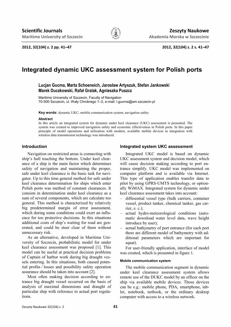
For user-friendly application, interface of model
was created, which is presented in figure 1.
Mobile communication system
The mobile communication segment in dynamic
under keel clearance assessment system allows
remote use of the DUKC model by an officer on the
ship via available mobile devices. Those devices
can be e.g.: mobile phone, PDA, smartphone, tab-
let, notebook, netbook, or the ordinary desktop
computer with access to a wireless network.
Lucjan Gucma, Marta Schoeneich, Jarosław Artyszuk, Stefan Jankowski, Marek Duczkowski, Rafał Gralak, Agnieszka Puszcz
42 Scientific Journals 32(104) z. 2
Marine segment
The system is based on wireless data transmis-
sion technology using contemporary techniques of
radio communication available on the Polish tele-
communications market. Depending on the user’s
access point and the type of mobile device (the
software), among other types, the following tech-
nologies are used:
– GPRS/EDGE;
– UMTS (HSPA) / CDMA2000;
– WiFi / Wi-Max / HiperLAN.
Wireless communication is used within the ship
– land communication. The rest of the data from the
operator's server of wireless transfer of information
to the server at the Maritime University of Szczecin
is wired with DSL technology.
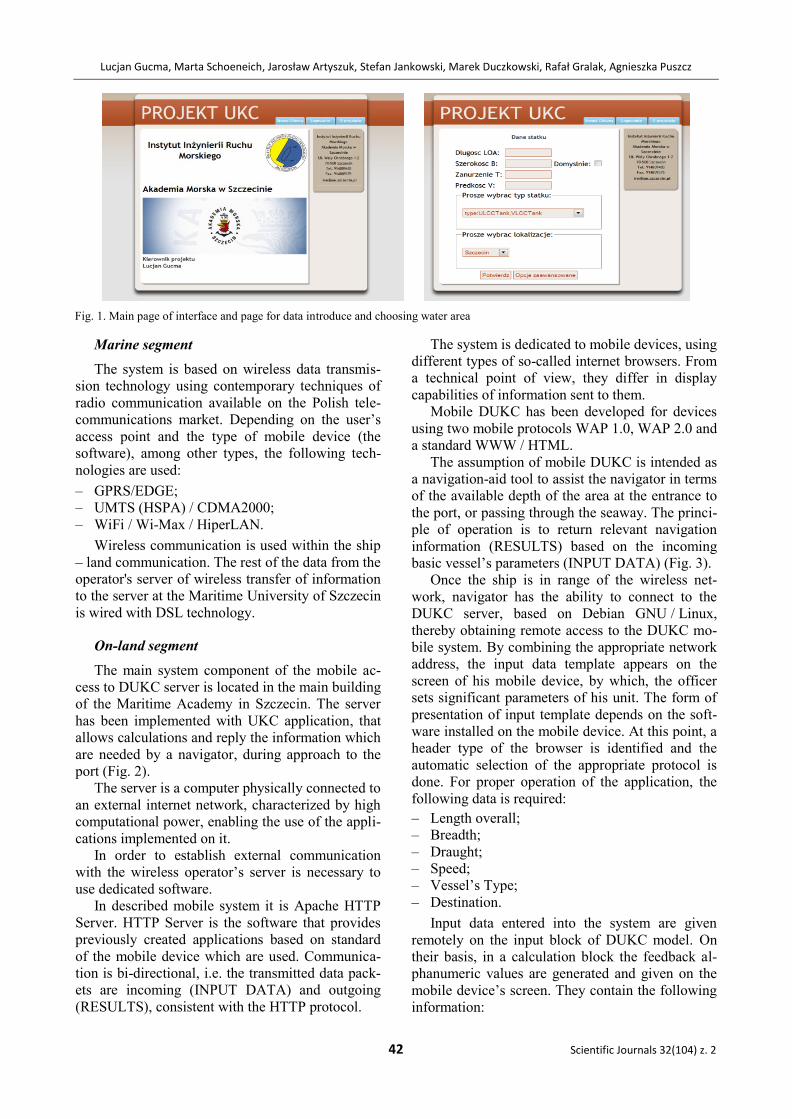
On-land segment
The main system component of the mobile ac-
cess to DUKC server is located in the main building
of the Maritime Academy in Szczecin. The server
has been implemented with UKC application, that
allows calculations and reply the information which
are needed by a navigator, during approach to the
port (Fig. 2).
The server is a computer physically connected to
an external internet network, characterized by high
computational power, enabling the use of the appli-
cations implemented on it.
In order to establish external communication
with the wireless operator’s server is necessary to
use dedicated software.
In described mobile system it is Apache HTTP
Server. HTTP Server is the software that provides
previously created applications based on standard
of the mobile device which are used. Communica-
tion is bi-directional, i.e. the transmitted data pack-
ets are incoming (INPUT DATA) and outgoing
(RESULTS), consistent with the HTTP protocol.
The system is dedicated to mobile devices, using
different types of so-called internet browsers. From
a technical point of view, they differ in display
capabilities of information sent to them.
Mobile DUKC has been developed for devices
using two mobile protocols WAP 1.0, WAP 2.0 and
a standard WWW / HTML.
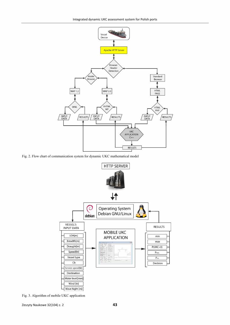
The assumption of mobile DUKC is intended as
a navigation-aid tool to assist the navigator in terms
of the available depth of the area at the entrance to
the port, or passing through the seaway. The princi-
ple of operation is to return relevant navigation
information (RESULTS) based on the incoming
basic vessel’s parameters (INPUT DATA) (Fig. 3).
Once the ship is in range of the wireless net-
work, navigator has the ability to connect to the
DUKC server, based on Debian GNU / Linux,
thereby obtaining remote access to the DUKC mo-
bile system. By combining the appropriate network
address, the input data template appears on the
screen of his mobile device, by which, the officer
sets significant parameters of his unit. The form of
presentation of input template depends on the soft-
ware installed on the mobile device. At this point, a
header type of the browser is identified and the
automatic selection of the appropriate protocol is
done. For proper operation of the application, the
following data is required:
– Length overall;
– Breadth;
– Draught;
– Speed;
– Vessel’s Type;
– Destination.
Input data entered into the system are given
remotely on the input block of DUKC model. On
their basis, in a calculation block the feedback al-
phanumeric values are generated and given on the
mobile device’s screen. They contain the following
information:
Fig. 1. Main page of interface and page for data introduce and choosing water area
Integrated dynamic UKC assessment system for Polish ports
Zeszyty Naukowe 32(104) z. 2 43
Fig. 2. Flow chart of communication system for dynamic UKC mathematical model
Fig. 3. Algorithm of mobile UKC application
Lucjan Gucma, Marta Schoeneich, Jarosław Artyszuk, Stefan Jankowski, Marek Duczkowski, Rafał Gralak, Agnieszka Puszcz
44 Scientific Journals 32(104) z. 2
• Water level;
• Squat;
• P(UKC < 0) – probability, that the UKC value
will be less than 0;
• P95% – probability at 95% confidence level that
UKC < 0;
• P5% – probability at 5% confidence level that
UKC < 0;
• Max draught.
In the assumptions, the layout designed for mo-
bile devices using a mobile access to the DUKC is
limited to a minimum. The aim is to increase appli-
cation availability for older devices, maximizing
the speed of the program, and to minimize costs of
data transfer. If the HTTP header will recognize the
standard (not mobile) web browser, the application
redirects the connection to the DUKC in the full
version.
Installed system
Installed operating system on server is Debian
GNU/Linux. Distribution is maintained in stable
version, which is updated once a month. System
kernel is in version 2.6.26. Server is used also as
www server, therefore, apache server with php5
module is installed.
Main database server is PostgreSQL in version
8.3. With this database system one can create data-
bases with unlimited size (limitation is only in
available disk space). Maximum size of one table is
limited to 32 TB, one row to 1.6 TB, and one field
to 1 GB. There is no limitation in number of rows
and indexes in table. Maximum number of columns
is in range between 250 and 1600, which depends
on column type.
For PostgreSQL there is plenty of available in-
terfaces for programmers, like C/C++, Java, .Net,
Perl, Python, Ruby, Tcl, ODBC and others librar-
ies. For connection to database in presented appli-
cation pqxx library in version 2.6.9 from standard
distribution repository is used. With this library
application can execute SQL statements directly on
server.
MySQL server in version 5.0.51a is installed as
a secondary database system. It is used for manag-
ing users passwords.
Database access
Due to the fact, that www service is available on
server, administration tools like phppgadmin and
phpmyadmin are installed. With these tools remote
connection and database managing is possible. In
internal University network PostgreSQL database is
available on port 5432, from the outside connection
is restricted for security reasons.
In dataset system there for better data handling
were created following tables:
• Ship’s types table – it contains for each ship
with specific type and length over all infor-
mation about parameters such as length between
perpendiculars, hull coefficient of form, breadth,
service speed and waving influence.
• Water level table – it contains information about
water level for given localization and time.
• Squat table – it contains information for each
localization about parameters such as name of
method, method symbol, delta, standard devia-
tion and calculation weight.
• Depth table – it contains information about
depths in each localization.
• Conversion table – due to the fact that data in
squat table are common for some ports conver-
sion table was created.
• Password table – it contains password for used
with authorization to use application.
Tables are mostly manually updated. This is
caused by integration issues and data specification.
Only water level table is automatically updated
from website. To provide this update bash script
was created.
Applications of probabilistic models components in the system – example
There are a number of factors which during
operation of the waterways have an impact on the
under keel clearance. These factors are on the both
side: the area and ships.
Depth of waterways is a major parameter influ-
encing vessels under keel clearance. The nautical
publications such as pilots, port guides, maps, etc.
usually give the technical depth and width of in-
dividual areas which should be ensured through
actions of responsible maritime administration.
From the ship side draft is primarily affected on
under keel clearance. Draught of the vessel is con-
stant only for a moored ship unless the cargo or
ballast operations are carried out. In the case of
a ship in motion we are dealing with dynamic
changes in the draught, which is the result of:
– longitudinal movement of the vessel- hydrody-
namic force creates on the hull which causes the
increase of draft and trim change (subsidence);
– roll of the ship; roll may be caused by a ship
rocking on the wave, wind pressure on the lat-
eral surfaces of ship or course alters.
Water area sedimentation model
Model is based on the determination of the
depths of the waterway sections. Studied fairway
Integrated dynamic UKC assessment system for Polish ports
Zeszyty Naukowe 32(104) z. 2 45
has a trapezoidal cross-section. Measured points
and determined fairway axis (designated and re-
ceived from the maritime office) are as a input data.
Following stages can be distinguished:
– The division of the waterway into sections. Due
to the varied nature of the Szczecin-Świnoujście
fairway appropriate sections were distinguished:
the Port of Świnoujście, Piastowski Canal,
Zalew Szczeciński, Roztoka Odrzańska, Police
Turn, Szczecin and its channels.
– Each of the designated sections was divided into
smaller sections of 1 km, for which every 50 m
straight lines perpendicular to the axis were es-
tablished.
– As a center of the coordinate system adopted
axis of the fairway.
– For a given cross section (perpendicular line)
specified depths on the right and left of center of
the track.
– This results in the depth distribution for the
sections and depth frequency.
– Determined depths for a given profile are
implemented in the model UKC.
The program randomizes one of the presented
depth in profile of each loop and for randomly
selected depth (distribution) draws a deep value.
The number of draws may be variable, which will
also change the amount of cross-sections used in
the model.
In order to facilitate measurements UTM coor-
dinate system is used.
Knowing the size of the average annual silt layer
and the date of recent sounding is possible to
reduce the depth and reservoir siltation determined
value can be used to determine the actual depth of
the area [3]. For this purpose based on surveys of
the fairway transverse profiles were determined at
specified sections.
Surveys covering the period 2006–2009 are
stored in a *.dxf file that information on the depth
is presented in the form of a polyline. Each of
the polyline represents the appropriate isobaths
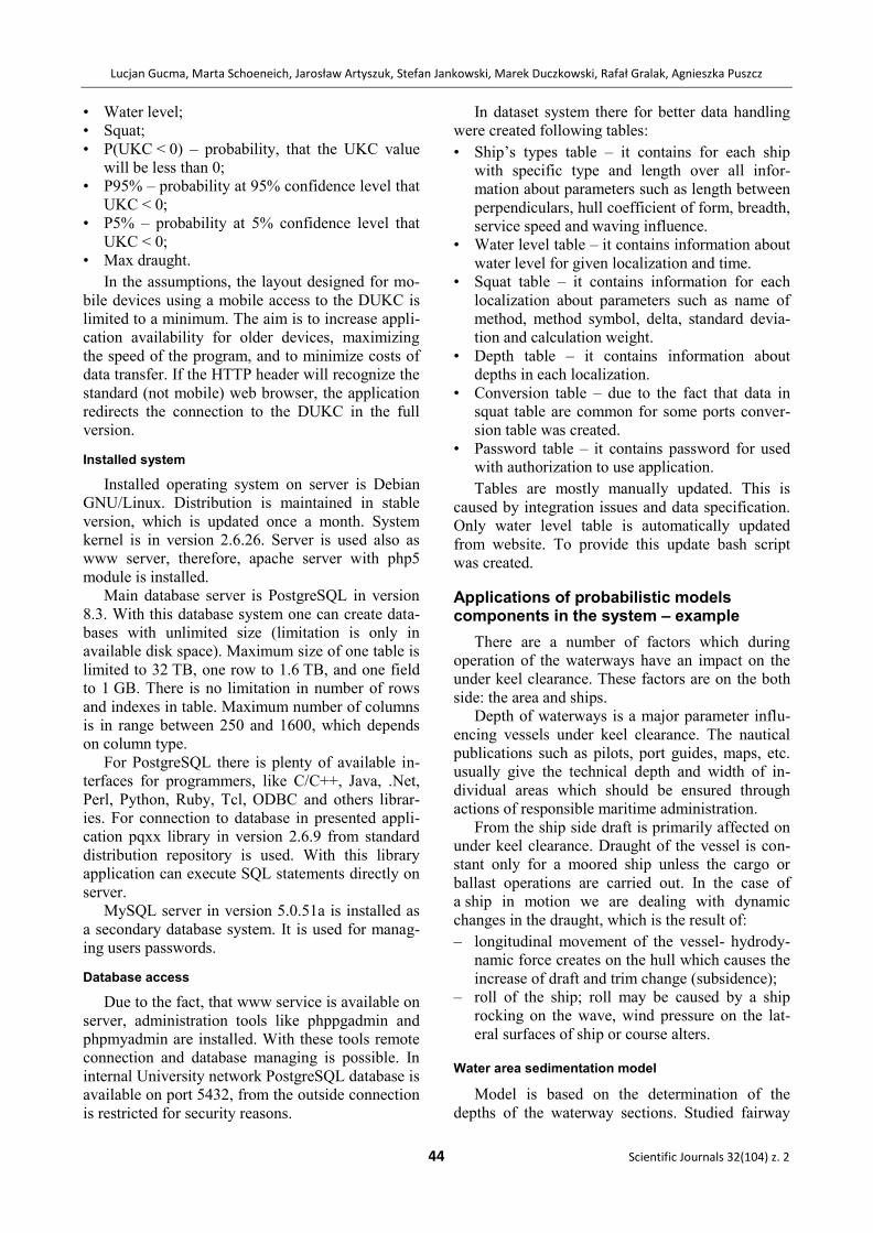
(Fig. 4).
Fig. 4. Soundings of one section of Szczecin–Świnoujście
fairway
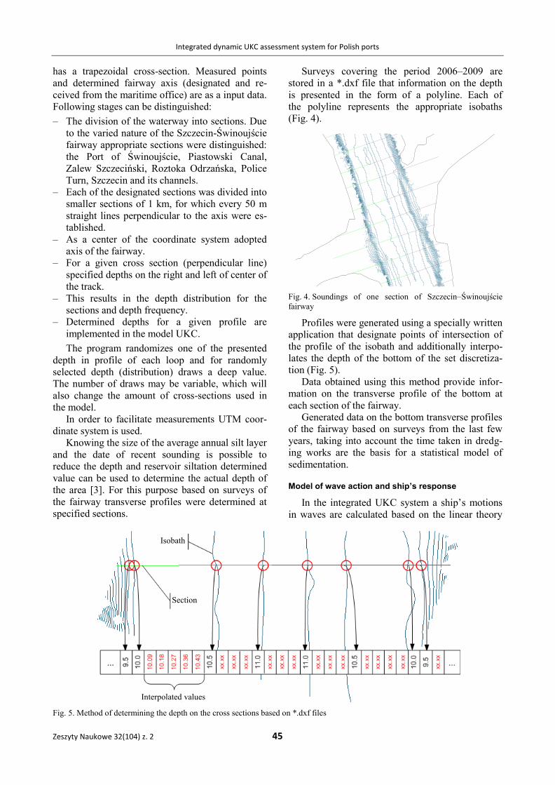
Profiles were generated using a specially written
application that designate points of intersection of
the profile of the isobath and additionally interpo-
lates the depth of the bottom of the set discretiza-
tion (Fig. 5).
Data obtained using this method provide infor-
mation on the transverse profile of the bottom at
each section of the fairway.
Generated data on the bottom transverse profiles
of the fairway based on surveys from the last few
years, taking into account the time taken in dredg-
ing works are the basis for a statistical model of
sedimentation.
Model of wave action and ship’s response
In the integrated UKC system a ship’s motions
in waves are calculated based on the linear theory
Fig. 5. Method of determining the depth on the cross sections based on *.dxf files
Isobath
Section
Interpolated values
Lucjan Gucma, Marta Schoeneich, Jarosław Artyszuk, Stefan Jankowski, Marek Duczkowski, Rafał Gralak, Agnieszka Puszcz
46 Scientific Journals 32(104) z. 2
of ships motions. The motions in irregular wave are
calculated on the principle of linear superposition
of regular wave contributions. In the steady-state
conditions (after some time required for stabilising
the motions to reach the asymptotic behaviour) the
amplitude of regular (harmonic) motions and corre-
sponding phase lag can be solved by means of the
following well-known algebraic equation:
6...,,1,6...,,1,
2
kjF
uNimMB
jAWV
kAjkEjkjkEjk (1)
where:
ukA – complex amplitude of k-th motion (in direc-
tion of k, values {1,2,3} denote translational
motions along x, y, z axes respectively, val-
ues {4,5,6} indicate angular motions around
the axes), the complex amplitude comprises
information on the right (real) amplitude and
the phase;
FWV jA – complex amplitude of j-th wave excitation
force (in direction of j), in common linear
assumptions the wave force real amplitude is
proportional to wave amplitude (or height);
E – encounter frequency (as equal to the fre-
quency of wave excitation force, which ac-
cording to the linear model of vibration also
produces the same frequency of final mo-
tions);
Mjk – ship’s mass and inertia matrix (6 x 6);
mjk – virtual (added) mass matrix, represents the
surrounding water (as ideal fluid) inertia
forces i.e. acceleration-related forces;
Njk – damping matrix, represents velocity-related
forces;
Bjk – restoring matrix, represents the hydrostatic
forces i.e. displacement-related forces.
Considering the expression (1) with regard to
a given encounter frequency, the resulting real
amplitude of motion is proportional (linearly
dependent) to the wave amplitude. This leads to
a wide adoption of the so-called transfer functions
or response amplitude operators. Besides, basically
referring to such constant ratios of motion / wave
amplitude as function of frequency, the transfer
functions (or RAOs) in wider sense should also
contain the phase angle between wave and a ship’s
motion [4].
The developed algorithm and computer applica-
tion is a dynamically linked library working on the
Linux platform – the operating system of a dedi-
cated UKC server. The software computes ship’s
linear motions in pseudo time-domain for irregular
seaway in that the time series of elementary 6
motions (3 linear and 3 angular) are generated as
composed of a sum of harmonic oscillations. Each
of these harmonic responses is produced by a har-
monic wave contribution, the amplitude and abso-
lute frequency of which is taken from an actual
wave spectrum.
The wave spectrum is based on a significant
wave height and characteristic period. Both terms
are correlated to each other and are specific for
particular nautical area, also for the Świnoujście–
Szczecin waterways. The software’s open architec-
ture also allows for an arbitrary wave spectrum
definition.
The mentioned harmonic motion is, however,
given an encounter frequency (as the real excitation
frequency from the wave) that is based on a ship’s
speed, wave incidence angle, water depth. The
latter influences the wave number or wave celerity
(in other words the wave propagation velocity).
Finally, an amplitude of the harmonic motion is
established according to the harmonic wave ampli-
tude and RAO value (treated in narrow sense as the
amplitude multiplier). Additionally, a phase angle
is determined. Both, RAOs and phase angles have
been computed off-line and stored in lookup tables,
they constitute a ship’s complete and constant hy-
drodynamic motion response characteristics, though
in our pseudo time-domain approach we solely
concentrate on asymptotic steady-state oscillations
(the transients or the so-called memory effects are
disregarded). The RAOs and phases are both func-
tions of 4 arguments – wave absolute frequency,
incidence angle, ship's speed and water depth ratio
(h/T – water depth divided by ship’s draught).
The software package comprises the following
files:
sk_dlib1.so – The main simulation dynamic library
(in binary format for commercial distribu-
tion). The source code was written in C++
and compiled by means of the standard (in-
ternal) Linux compiler “g++”. The library
functions may also be called from a source
code of other languages if the function inter-
face compatibility is preserved.
*.rao – A file type that contains the mentioned
ship’s specific hydrodynamic database with
RAOs and phase angles. Within the consid-
ered UKC project scope up to 8 ship models
were prepared as typical for Świnoujście and
Szczecin. Each [.RAO] file defines the coor-
dinates of ship’s gravity centre and 4-argu-
ment discrete transfer functions (both for
amplitude and phase) for this centre. Here the
arguments are: absolute wave frequency
(40 values, 0 to 1.32, every 0.033), wave
incidence angle WVrel (13 values, 0 to 180,
Integrated dynamic UKC assessment system for Polish ports
Zeszyty Naukowe 32(104) z. 2 47
every 15), ship’s speed v (5 values, equally
spaced from 0 to v=max.), water depth ratio
h/T (6 values – 1.05, 1.2, 1.5, 2, 5, 500).
*.spe – A file type which deals with a normalised
wave spectrum for a dedicated nautical area –
precisely the wave energy spectral density.
The normalisation means dividing the wave
energy by the square of the wave significant
height h1/3. This relation is here discretely
stored as function of wave frequency (in-
dependent variable) and characteristic period
T1 (parameter). The [.SPE] file also includes
properly discretised numerical evaluations of
the so-called dispersion relation, which pro-
vides the wave number k as function of wave
frequency and water depth ratio h/T – the
computations were made in Mathematica.
The dispersion relation is of course inde-
pendent from a wave spectrum, but is tempo-
rarily stored in this file. The wave number k
is necessary for converting the absolute (real)
spectrum into the encounter spectrum. Due to
the water depth reduction in port areas the
wave number increases (under the same
wave frequency), which means the shorter
and slower wave. It shall be here stressed that
in oceanographic terms, i.e. relating the wave
length to water depth (/h), the shallow water
wave is called a long wave.
Summarising, the transfer functions (in [.RAO]
files) denote a ship’s dynamic model, while the
wave spectrum (in [.SPE] files) sets a wave envi-
ronment’s model.
The transfer functions for ships motions were
determined using a strip method. At the present
early stage of research and development works the
commercial software SEAWAY was employed.
Because the applied reference system is a bit dif-
ferent from that of SEAWAY (strictly it assumes
a right-handed coordinate system widely used in
ship manoeuvring) a recalculation of phase angles
for some degrees of freedom was performed. The
assessment accuracy of the transfer functions thus
corresponds to the general SEAWAY’s accuracy, in
particular to both numerical accuracy and adequacy
of hydrodynamic assumptions (approximations).
Conclusions
Accommodate big draught vessel without an ex-
pensive investment process is possible only by using
modern tools which supported process of making
decision by Port Captain. Such a tool which is an
integrated system of under keel clearance assess-
ment, which could improved Polish ports effective-
ness during acceptable draught appreciation. Pre-
sented system was built on the basis of probabilistic
model of under keel clearance assessment.
References
1. GUCMA L., SCHOENEICH M.: Probabilistic method and deci-
sion support system for ships under keel clearance evalua-
tion in port entrances. Proc.of International Probabilistic
Symposium, Ghent 2007.
2. GUCMA L., SCHOENEICH M.: Probabilistyczny model okre-
ślania zapasu wody pod stępką zbiornikowców LNG na
podejściu do wybranych terminali w Polsce. Proc. of
Transport XXI Conference, 2007.
3. NOWICKI A.: Wiedza o manewrowaniu statkami morskimi.
Trademar, Gdynia 1999.
4. JOURNEE J.M.J., PINKSTER J.: Introduction in Ship Hydro-
mechanics. Delft University of Technology, 2002.
5. EISENTRAUT P., HELMLE B.: PostgreSQL-Administration
Current version at publication: 8.3 Format: Hardback Pub-
lished: October 2008.