Daytona Beach M i d t o w n Master Plan
82
Midtown Masterplan City of Daytona Beach + F l o r i d a A & M U n i v e r s i t y SCHOOL OF ARCHITECTURE Daytona Beach Development Standards & Design Guidelines M i d t o w n Master Plan
Transcript of Daytona Beach M i d t o w n Master Plan

Midtown Masterplan
C i t y o f D a y t o n a B e a c h + F l o r i d a A & M U n i v e r s i t y SCHOOL OF ARCHITECTURE
Daytona Beach
Development Standards & Design Guidelines M i d t o w n Master Plan
Midtown Masterplan
C i t y o f D a y t o n a B e a c h + F l o r i d a A & M U n i v e r s i t y SCHOOL OF ARCHITECTURE
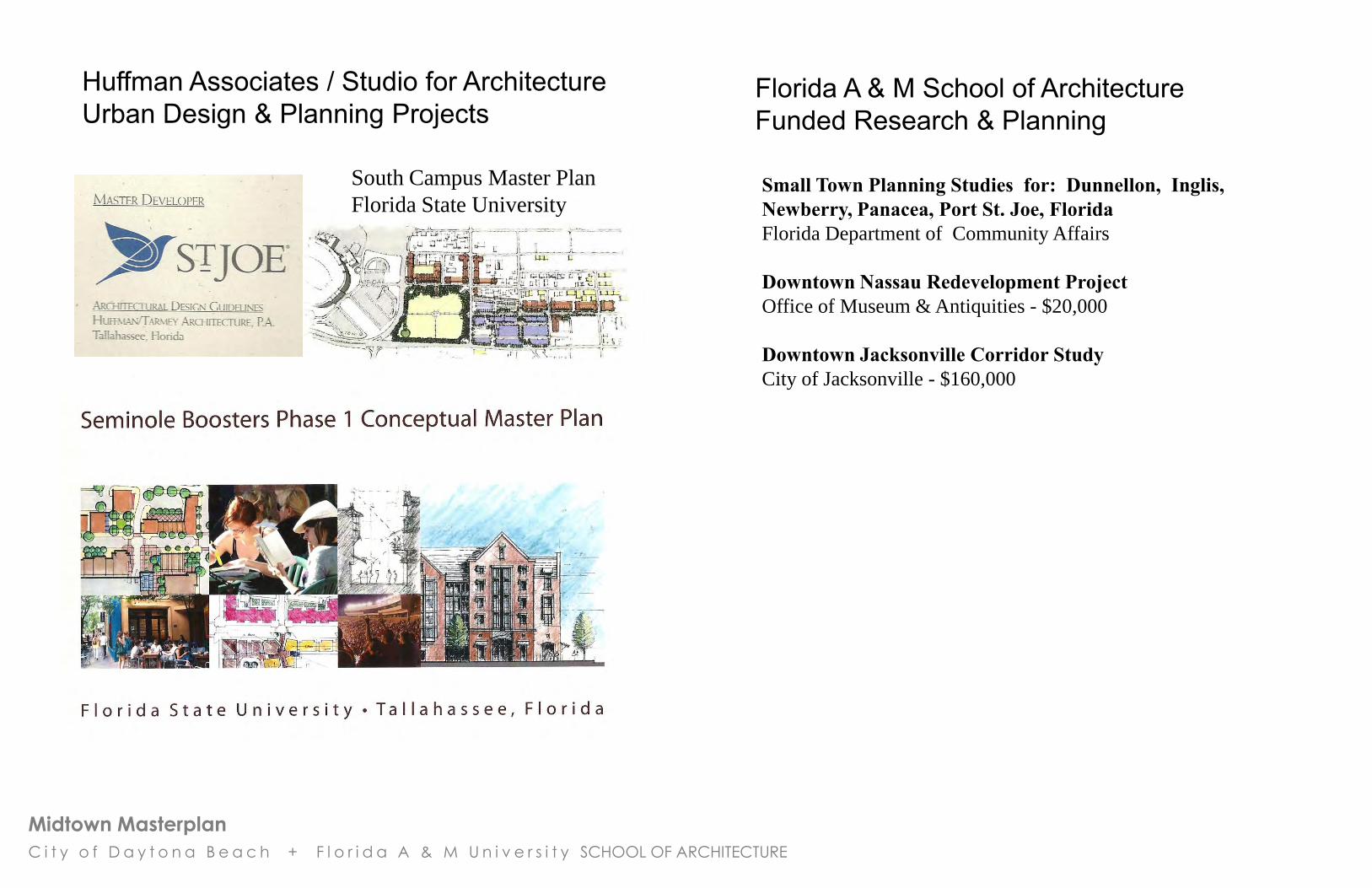
South Campus Master Plan
Florida State University
Huffman Associates / Studio for Architecture Urban Design & Planning Projects
Florida A & M School of Architecture Funded Research & Planning
Small Town Planning Studies for: Dunnellon, Inglis, Newberry, Panacea, Port St. Joe, Florida Florida Department of Community Affairs
Downtown Nassau Redevelopment Project Office of Museum & Antiquities - $20,000
Downtown Jacksonville Corridor Study City of Jacksonville - $160,000
Midtown Masterplan
C i t y o f D a y t o n a B e a c h + F l o r i d a A & M U n i v e r s i t y SCHOOL OF ARCHITECTURE
Midtown Master Plan, Daytona Beach, FL Florida A & M University, School of Architecture
TABLE OF CONTENTS
1. Plan Development Process (pages 1 – 8)
1.1 Introduction
1.2 Overview of the Midtown District Area
1.3 Community Workshops
1.4 Existing Conditions 1.4.1 Existing Conditions Analysis 1.4.2 Existing Land Use Pattern 1.4.3 Vacant Properties 1.4.4 Images of Midtown - Buildings & Places
1.4.5 History - People & Places
2. Generating the Plan (pages 9 – 16)
2.1 Vision Statement
2.2 Planning Principles & Standards
2.3 Urban Design Principles & Patterns
2.4 Streets & Transit
2.5 Parks & Green Space
2.6 Community Gardens & Public Markets
2.7 Design for Everyone: Universal Design
3. Midtown Redevelopment Master Plan (pages 17 – 24)
3.1 12 Actions
3.2 Neighborhood Structure Plan
3.3 Streets & Transit Plan
3.3.1 Bicycle Lane & Trail Plan
3.4 Proposed Parks, Greenways & Street Tree Plan
3.5 On-Street Parking Plan
3.6 Proposed Public Spaces, Heritage Trail & Monuments
4. Redevelopment Proposals (pages 25 – 45)
4.1 Redevelopment Focus Areas Plan
4.2 to 4.2.7 Midtown Center Plan - Site 1 - RENDERINGS
4.3 & 4.3.1 Midtown Center Plan - Site 1: Town Square Option
4.4 & 4.4.1 Huger Park - Typical Neighborhood Center - Site 2
4.5 Redevelopment Site 3 (ISB & Nova Rd)
4.6 Redevelopment Site 4a (ISB west)
4.7 Redevelopment Site 4b (ISB central)
4.8 Public Infrastructure / Lincoln Greenway - Site 7
4.9 Dickerson Center Park Expansion - Site 9
4.10 Thurman Gardens & Assisted Living Center –Site 10
4. Redevelopment Proposals (continued)
4.11 Implementation - Immediate Actions: 2012 to 2015 4.11.1 Implementation –
Mid-Range Actions: 2016 to 2025 Long-Range Actions: 2026 to 2035
5. Development Standards and Design Guidelines + Illustrations and Examples (pages 46 – 80)
5.1 Midtown Development Districts 1. Midtown Center / ISB 2. Neighborhood Center / Mixed Use 3. Activity Center Mixed Use / ISB & Nova Rd 4. Neighborhood Transition 5. Residential Preservation 6. Residential Preservation / Historic District Infill 7. Eco Industrial 8. University Transition
5.2 Climate Responsive / Green Design Standards
5.3 Lighting, Signage & Color Standards
APPENDICES (in separate booklet)
Appendix A:
Midtown CRA Board Members
Appendix B:
Listing & Summaries of Community / Workshop Meetings
Appendix C:
GIS Mapping & Research
Appendix D:
Excerpts from previous plans and studies
Wade – Trim Report
Misc. Corridor Studies
Appendix E:
Public Space, Landmarks & Architectural Character –
Inventory & Sketch Studies
Appendix F:
Graduate Student Design Proposals & Renderings
Midtown Masterplan
C i t y o f D a y t o n a B e a c h + F l o r i d a A & M U n i v e r s i t y SCHOOL OF ARCHITECTURE
1. Plan Development
Process

Midtown Masterplan
C i t y o f D a y t o n a B e a c h + F l o r i d a A & M U n i v e r s i t y SCHOOL OF ARCHITECTURE
Plan Development Process:
1.1 Introduction The City of Daytona Beach, Florida and the Midtown CRA contracted
with the Florida A & M University School of Architecture to develop a
Master Plan with Design and Development Standards that will guide
the growth and land development process for the Midtown CRA
area. The plan is based on historical research, existing constraints and
opportunities and a series of workshops with citizens, home and
business owners and neighborhood participants. The plan has also
been developed with input and assistance from the Midtown Board
and the Daytona Beach Redevelopment Department.
This document is a record of the history and evolution of the Midtown
District in Daytona Beach, Florida. It is also a blueprint for positive
growth and change over the next 50 years. It is based on
participatory community planning plus new urbanist design and
place making principles. The Master Plan and Development
Standards chart a course for preserving the historic buildings, places
and significant institutions in Midtown; while creating incentives and
quality standards for new growth.
The Master Plan and Development Code forms the foundation of a
place based economic development strategy.
“Place based planning with design standards and guidelines
are a catalyst for economic development”
Hazel Borys, Placemaking Consultant
Common Ground – Real Estate & Smart Growth
1

Midtown Masterplan
C i t y o f D a y t o n a B e a c h + F l o r i d a A & M U n i v e r s i t y SCHOOL OF ARCHITECTURE
Plan Development Process :
1.2 Overview of the Midtown District Area The Midtown CRA is an historic area that is located in the geographic center of Daytona Beach approximately half way between the Atlantic coast beaches on the east and the International Speedway and Airport area / I - 95 on the west.
Midtown has many assets, including: • an excellent location • a rich history of African American culture
• Bethune Cookman University • a significant area of contributing historic structures • an interconnected street grid with good connections to the larger community • ISB has the potential to be an attractive “urban boulevard” with new mixed use development. • affordable vacant property that can accommodate growth and redevelopment.
There are also many challenges: • there is a deficit of business and home ownership • a decreased tax base in relation to CRA area • income levels are generally lower than the adjacent community • a concentration of public housing • outdated infrastructure & inadequate stormwater facilities • inadequate parks, playgrounds, recreation and public spaces • significant areas of vacant property • a lack of basic services and shopping • ISB is a “cut through highway” that divides north & south Midtown. • no identifiable Midtown “center”
The Midtown Master Plan presents an urban design and community planning framework, including Development Standards that are specifically designed for Midtown, that will provide a guiding vision for future growth. The plan acknowledges and preserves the assets listed above while addressing the challenges and barriers that are limiting reinvestment in the area.
Midtown CRA District: Location & Context
2
MIDTOWN
CRA DISTRICT

Midtown Masterplan
C i t y o f D a y t o n a B e a c h + F l o r i d a A & M U n i v e r s i t y SCHOOL OF ARCHITECTURE
Plan Development Process : 1.3 Community Workshops
An essential element of the planning process was the community’s involvement. There were 6
workshop – neighborhood review discussions as the plan was developed. Workshop locations
included the Dickerson Community Center, Bethune Cookman University and City Hall. The Midtown CRA Board members provided leadership and guidance throughout the process.
3
Workshop 1 Summary •There was a high turn-out; approximately 65 people.
•Attendees included a diverse group of Midtown citizens and area residents, and representatives from the City of Daytona Beach,
Volusia County, Daytona State College, and churches.
•The community wants attractive streets with trees, businesses, nice
street lights, underground utilities, a family-friendly, livable
community.
•Orange Avenue is used by Daytona Beach citizens as a short-cut
between Nova and Beach St. to access Atlantic Blvd. •Crossing ISB is dangerous and difficult for children who want to go to
the local softball fields and the large recreation center.
•The health, well-being, and safety of the citizens is essential.
•There is a strong sense of community and desire to better Midtown
amongst the key stakeholders, however, the groups have not formed
a cohesive coalition.
•The community is open to national restaurant and retail uses at ISB. •The Academic Institutions want a safe, attractive environment for their
students, and space for future expansions.
•Flooding is a problem in certain areas. •Safety and livability need improvement.
Midtown Masterplan
C i t y o f D a y t o n a B e a c h + F l o r i d a A & M U n i v e r s i t y SCHOOL OF ARCHITECTURE
Plan Development Process :
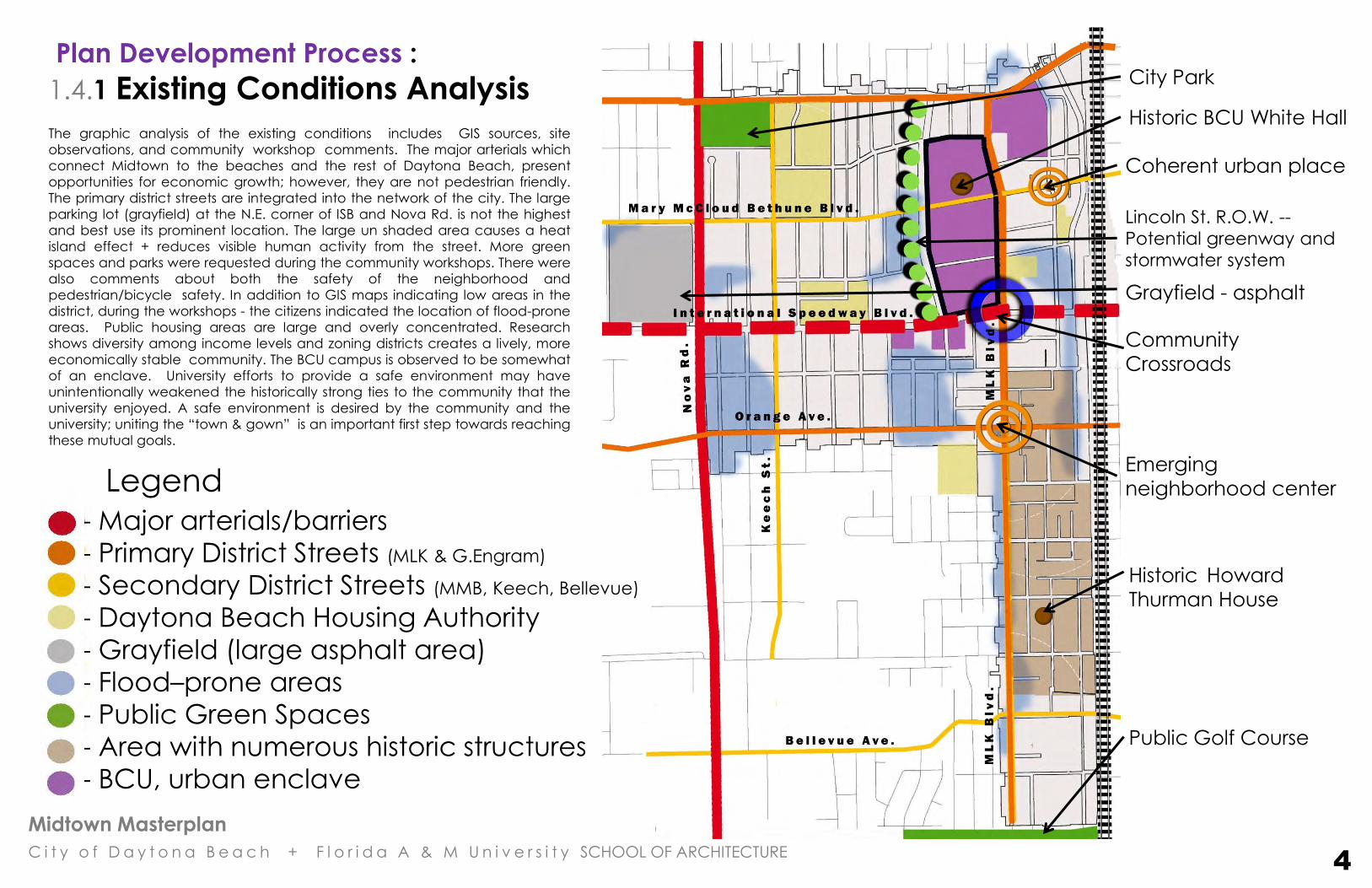
1.4.1 Existing Conditions Analysis
- Major arterials/barriers
- Primary District Streets (MLK & G.Engram)
- Secondary District Streets (MMB, Keech, Bellevue)
- Daytona Beach Housing Authority
- Grayfield (large asphalt area)
- Flood–prone areas
- Public Green Spaces
- Area with numerous historic structures
- BCU, urban enclave
Historic BCU White Hall
Coherent urban place
Emerging
neighborhood center
Historic Howard
Thurman House
Public Golf Course
City Park
Legend
The graphic analysis of the existing conditions includes GIS sources, site
observations, and community workshop comments. The major arterials which
connect Midtown to the beaches and the rest of Daytona Beach, present
opportunities for economic growth; however, they are not pedestrian friendly.
The primary district streets are integrated into the network of the city. The large
parking lot (grayfield) at the N.E. corner of ISB and Nova Rd. is not the highest
and best use its prominent location. The large un shaded area causes a heat
island effect + reduces visible human activity from the street. More green
spaces and parks were requested during the community workshops. There were
also comments about both the safety of the neighborhood and
pedestrian/bicycle safety. In addition to GIS maps indicating low areas in the
district, during the workshops - the citizens indicated the location of flood-prone
areas. Public housing areas are large and overly concentrated. Research
shows diversity among income levels and zoning districts creates a lively, more
economically stable community. The BCU campus is observed to be somewhat
of an enclave. University efforts to provide a safe environment may have
unintentionally weakened the historically strong ties to the community that the
university enjoyed. A safe environment is desired by the community and the
university; uniting the “town & gown” is an important first step towards reaching
these mutual goals.
Grayfield - asphalt
Lincoln St. R.O.W. --
Potential greenway and
stormwater system
Community
Crossroads
4

Midtown Masterplan
C i t y o f D a y t o n a B e a c h + F l o r i d a A & M U n i v e r s i t y SCHOOL OF ARCHITECTURE
Plan Development Process : 1.4. 2 Midtown CRA – Existing Land Use Pattern The current land use pattern does not follow a coherent plan. There are concentrations of lower density residential areas, the BCU
campus and “strip oriented” commercial development. Most of the uses are separated and fragmented. There is not a hierarchy of
public spaces with appropriate densities of uses / activities, and there is no identifiable center or “Main Street” in the community.
5
City Utilities Property

Midtown Masterplan
C i t y o f D a y t o n a B e a c h + F l o r i d a A & M U n i v e r s i t y SCHOOL OF ARCHITECTURE
Plan Development Process : 1.4.3 Midtown Area Vacant Parcels Pattern There are numerous vacant properties in the Midtown district. These “gaps” in the urban fabric depress property values and compromise
urban connectivity; however, they also offer affordable vacant property that can accommodate growth and redevelopment. The vacant
parcels include almost 120 acres of land that will add to the tax base when developed.
6

Midtown Masterplan
C i t y o f D a y t o n a B e a c h + F l o r i d a A & M U n i v e r s i t y SCHOOL OF ARCHITECTURE
Plan Development Process : 1.4.4 Images of Midtown - Buildings & Places
7

Midtown Masterplan
C i t y o f D a y t o n a B e a c h + F l o r i d a A & M U n i v e r s i t y SCHOOL OF ARCHITECTURE
Plan Development Process : 1.4.5 History - People & Places
8

Midtown Masterplan
C i t y o f D a y t o n a B e a c h + F l o r i d a A & M U n i v e r s i t y SCHOOL OF ARCHITECTURE
2. Generating
the Plan

Midtown Masterplan
C i t y o f D a y t o n a B e a c h + F l o r i d a A & M U n i v e r s i t y SCHOOL OF ARCHITECTURE
Generating the Plan : 2.1 Vision Statement :
9
Midtown Masterplan
C i t y o f D a y t o n a B e a c h + F l o r i d a A & M U n i v e r s i t y SCHOOL OF ARCHITECTURE
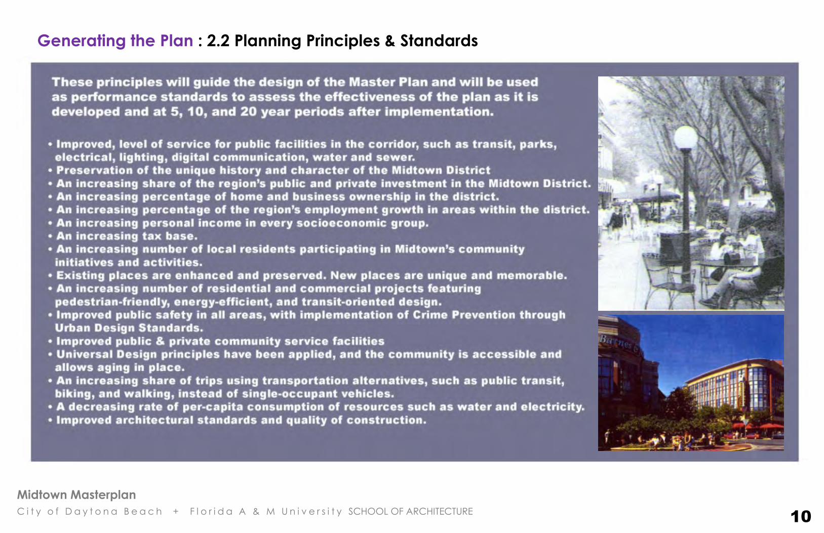
Generating the Plan : 2.2 Planning Principles & Standards
10

Midtown Masterplan
C i t y o f D a y t o n a B e a c h + F l o r i d a A & M U n i v e r s i t y SCHOOL OF ARCHITECTURE
Generating the Plan: 2.3 Urban Design Principles & Patterns
In Midtown, there are a number of design patterns that inform the plan, but the six (6) that are essential in creating a successful urban community are: 1. Preserve and extend the interconnected street / block network and establish small walkable blocks. 2. Build to the sidewalk; create defined streets and public spaces. 3. Locate surface and structured parking behind, on the side, below or above buildings.
4. Make retail and public storefronts / shops permeable and transparent on the ground level and include balconies / terraces that open to public streets, squares and courtyards.
5. Allow and encourage mixed use in horizontal and vertical development. 6. Establish a “Clear Center and Main Street” for the community. These simple design principles create a vibrant mix of compatible uses, provide adequate parking (while “taming” the “gray field deserts” of typical strip center parking), increase public safety due to more “eyes on the street” and promote a realistic market driven incremental development pattern. Additional principles that guide the Master Plan and Development Standards are:
Enrich the Public Realm The public realm includes all publicly owned streets, sidewalks, squares, parks, right of ways and other public open space and infrastructure. A good public realm encourages and facilitates walking. It allows and promotes a “public culture” of sitting & relaxing, of sidewalk cafes, neighborhood pubs & restaurants and other ”3rd places” that compliment work and home. The proposed Master Plan includes a series of new public squares and monuments that will become the primary “outdoor rooms” of the community and enhance the existing Black Heritage Trail
Create a pedestrian friendly environment In the Midtown Plan, vehicles and bicycles are accommodated and parking will be available and
convenient, but pedestrians will come first. The district has the potential to be a successful pedestrian environment; however, there are a number of key items that need to be implemented for that to occur. These include: sidewalk improvements & connectivity; access to transit; shade & protection from weather; visual interest, transparency & detail in the built environment; places to sit, meet, socialize and stage planned & informal community events.
11

Midtown Masterplan
C i t y o f D a y t o n a B e a c h + F l o r i d a A & M U n i v e r s i t y SCHOOL OF ARCHITECTURE
Address Human Scale The standard metric of successful placemaking is sensitivity to human scale. Large blank building facades lack human scale and essentially communicate “you are not welcome
here”. Successful urban environments address scale at every level. Buildings and places scaled to human movement include terraces, platforms, steps, niches, entries, canopies, windows, railings, details, materials, landscape and walking distances that relate to people and their scale.
Respect the scale & character of existing Historic District building patterns A new project that becomes part of a neighborhood begins with an owner’s and designer’s appreciation of the strengths of the existing context, plus an understanding of the intent of the Development Standards for a particular location. Neighborhood context is generally strong in Zone 5: Residential Historic Infill, Zone 6: Residential and Zone 8: University Transition.
In other zones and areas of Midtown, a new character will emerge as the Master Plan guides new development. Design for the Climate The Development Standards include basic Green Building strategies that address the coastal Florida climate. Traditional and contemporary architectural elements include: arcades, deep porches, awnings, canopies and green trellis walls for shade; and balconies, tall windows, French doors, shutters and light shelves for light and ventilation.
Design for Everyone
Universal design will inform public signage, seating, transit and mobility. Children, elderly, and differently abled residents will be considered in the design of new public spaces.
Safety and Crime Prevention Public areas will be safer through the application of CPTED (crime prevention through environmental design) principles. (CPTED) is a multi-disciplinary approach to deterring criminal behavior through environmental design. CPTED strategies rely upon the ability to influence offender decisions that precede criminal acts. CPTED is based [upon the theory that the proper design and effective use of the built environment can reduce crime, reduce the fear of crime, and improve the quality of life. Built environment implementations of CPTED seek to dissuade offenders from committing crimes by manipulating the built
environment in which those crimes proceed from or occur. The three most common built environment strategies are natural surveillance, natural access control and natural territorial reinforcement / maintenance.
Generating the Plan: 2.3 Urban Design: Principles & Patterns
12

Midtown Masterplan
C i t y o f D a y t o n a B e a c h + F l o r i d a A & M U n i v e r s i t y SCHOOL OF ARCHITECTURE
Generating the Plan:
2.4 Streets & Transit
Transit & cycling: • The existing bus loop will be maintained and extended to connect all
5 Neighborhood Centers as they become more established.
• New transit stops and shelters will be accessible, use green technology
for lighting and be designed to educate & celebrate the civil rights history of
the Midtown District.
• The proposed Amtrak Station (located at Magnolia Ave.) offers an opportunity
to connect the district to the larger regional and national rail transit system.
• The interconnected street network and urban scale create an ideal
environment for bicycle transit. Since traffic is dispersed in the grid,
most of the streets work well as shared lanes for motorists and cyclists;
however, certain streets need to be modified to include dedicated
bike lanes, these include: ISB, Nova, G. Engram, MMB Blvd., Orange
Ave., Bellevue Ave. and certain portions of MLK Blvd. and Keech St.
Street, Sidewalk & Infrastructure Improvements: As funds become available for street and R.O.W improvements – design elements
that support “streets for people” will be included throughout the district.
These elements include:
• pedestrian “bumpouts” at intersections & improved crosswalks
• wider resurfaced sidewalks with accessible curb transitions
• curb & gutters with improved drainage
• parallel & diagonal (on wider R.O.W.s) street parking
• street trees for shade, scale & traffic calming
• pedestrian oriented street lights with themed signage banners that provide
orientation for historic sites & Heritage Walk locations
• improved vehicular & pedestrian signalization
13
Midtown Masterplan
C i t y o f D a y t o n a B e a c h + F l o r i d a A & M U n i v e r s i t y SCHOOL OF ARCHITECTURE
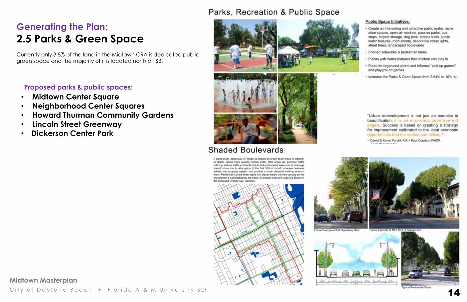
Generating the Plan:
2.5 Parks & Green Space Currently only 3.8% of the land in the Midtown CRA is dedicated public green space and the majority of it is located north of ISB.
REVISE
14
Proposed parks & public spaces:
• Midtown Center Square
• Neighborhood Center Squares
• Howard Thurman Community Gardens
• Lincoln Street Greenway • Dickerson Center Park
Midtown Masterplan
C i t y o f D a y t o n a B e a c h + F l o r i d a A & M U n i v e r s i t y SCHOOL OF ARCHITECTURE
Generating the Plan:
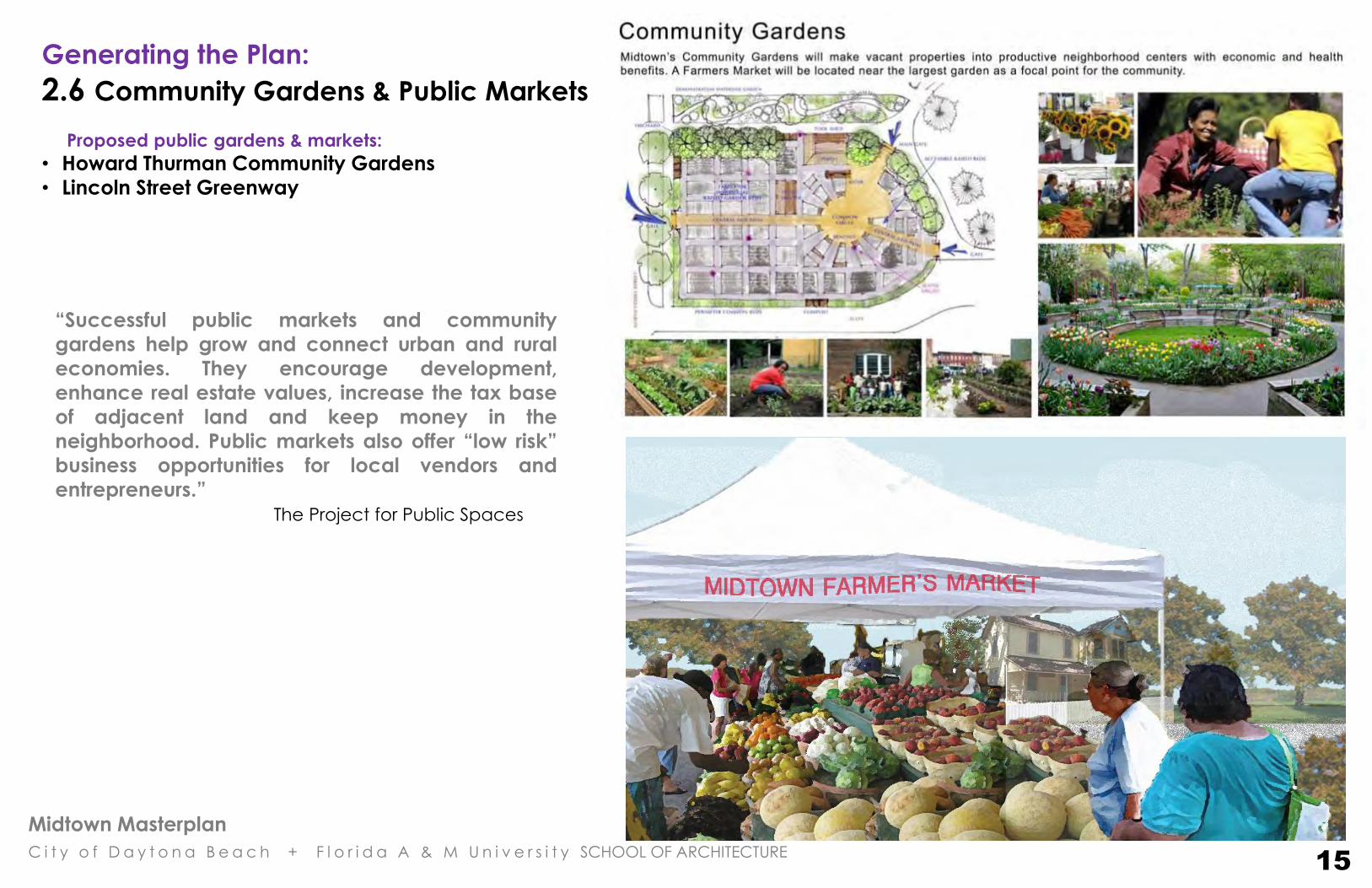
2.6 Community Gardens & Public Markets
Proposed public gardens & markets:
• Howard Thurman Community Gardens
• Lincoln Street Greenway
“Successful public markets and community
gardens help grow and connect urban and rural
economies. They encourage development,
enhance real estate values, increase the tax base
of adjacent land and keep money in the
neighborhood. Public markets also offer “low risk”
business opportunities for local vendors and
entrepreneurs.”
The Project for Public Spaces
15

Midtown Masterplan
C i t y o f D a y t o n a B e a c h + F l o r i d a A & M U n i v e r s i t y SCHOOL OF ARCHITECTURE
Generating the Plan: 2.7 Universal Design: Designing for Everyone
16

Midtown Masterplan
C i t y o f D a y t o n a B e a c h + F l o r i d a A & M U n i v e r s i t y SCHOOL OF ARCHITECTURE
3. Midtown Redevelopment
MASTER PLAN

Midtown Masterplan
C i t y o f D a y t o n a B e a c h + F l o r i d a A & M U n i v e r s i t y SCHOOL OF ARCHITECTURE
Master Plan: 3.2 Neighborhood Plan The district has been divided into five (5) sub–districts or “neighborhoods”,
and a “Town Center” located at the intersection of ISB AND MLK Blvd. The
Town Center connects with the “Main Street” portion of Martin Luther King
Blvd. (between Mary McCloud Bethune Blvd. & Orange Ave.)
The neighborhoods are organized around “5 neighborhood centers” and
5 minute pedestrian (1/4 mile) walking distance areas. The
neighborhoods will have identifiable centers with a mix of uses,
neighborhood services and transit stops. The neighborhood centers are
located based on the intersections of the primary streets and avenues in
the CRA District. Over time, each neighborhood will develop a unique
character within the larger Midtown district. Their size is based on the ¼
mile walking shed and typically range between 100 and 150 acres. The
new Land Development Regulations and future land use patterns are
based on this neighborhood structure. The highest densities and intensity
of uses will be at the Town Center Square and to a lesser degree at the
five neighborhood centers.
Initial Concept:
Sketch Study
18
INT’L SPEEDWAY BLVD.
GEORGE ENGRAM BLVD.
MLK
BLV
D.
ORANGE AVE.
NO
VA R
D.
MLK “MAIN STREET” SECTION
MMB BLVD.
BELLVUE AVE.
KEE
CH
ST.
Midtown Masterplan
C i t y o f D a y t o n a B e a c h + F l o r i d a A & M U n i v e r s i t y SCHOOL OF ARCHITECTURE
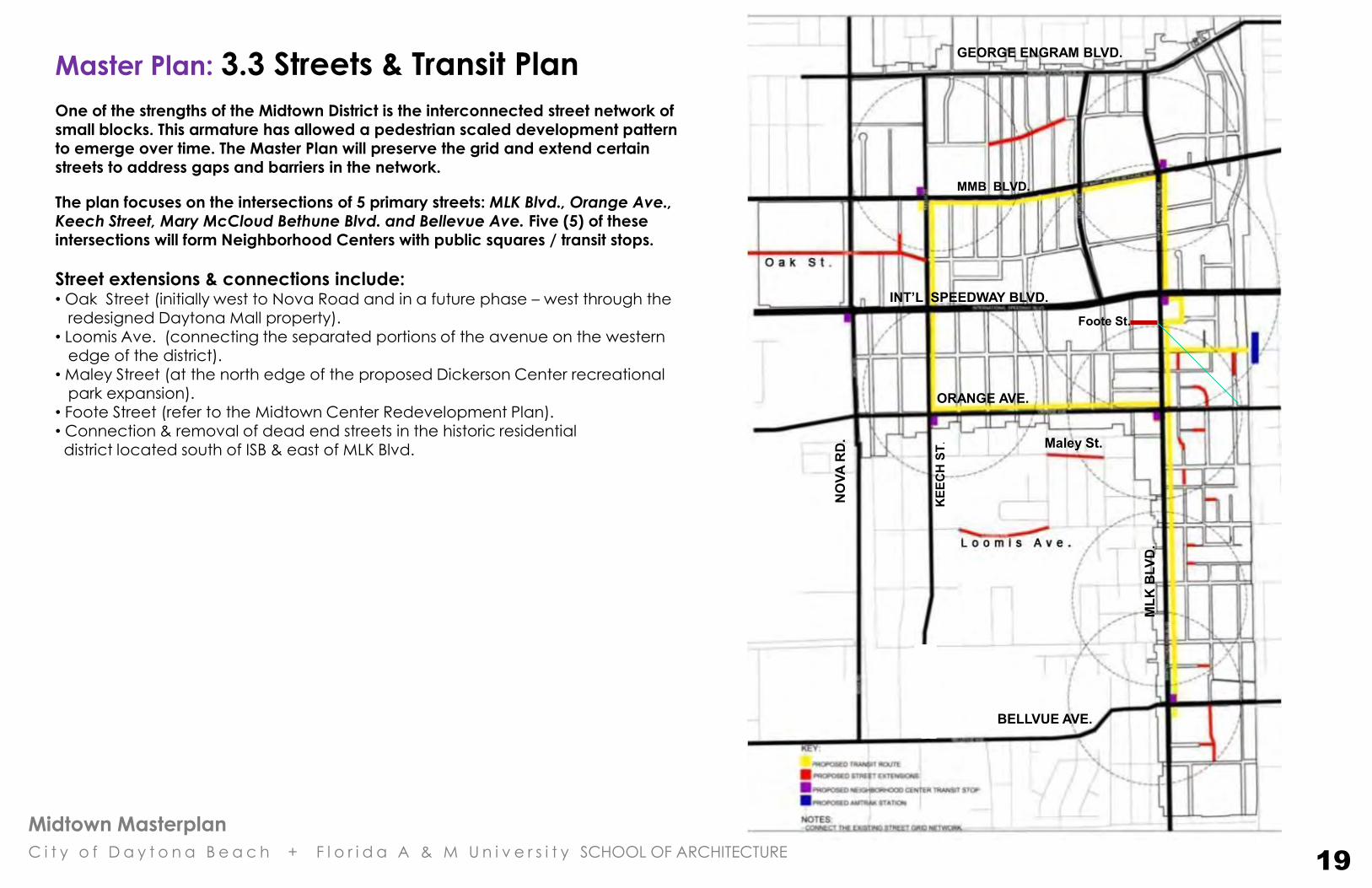
Master Plan: 3.3 Streets & Transit Plan
One of the strengths of the Midtown District is the interconnected street network of small blocks. This armature has allowed a pedestrian scaled development pattern to emerge over time. The Master Plan will preserve the grid and extend certain streets to address gaps and barriers in the network.
The plan focuses on the intersections of 5 primary streets: MLK Blvd., Orange Ave., Keech Street, Mary McCloud Bethune Blvd. and Bellevue Ave. Five (5) of these intersections will form Neighborhood Centers with public squares / transit stops.
Street extensions & connections include: • Oak Street (initially west to Nova Road and in a future phase – west through the redesigned Daytona Mall property). • Loomis Ave. (connecting the separated portions of the avenue on the western edge of the district). • Maley Street (at the north edge of the proposed Dickerson Center recreational park expansion). • Foote Street (refer to the Midtown Center Redevelopment Plan). • Connection & removal of dead end streets in the historic residential district located south of ISB & east of MLK Blvd.
19
Maley St.
Foote St.
INT’L SPEEDWAY BLVD.
GEORGE ENGRAM BLVD.
MLK
BLV
D.
ORANGE AVE.
NO
VA R
D.
KEE
CH
ST.
BELLVUE AVE.
MMB BLVD.

Midtown Masterplan
C i t y o f D a y t o n a B e a c h + F l o r i d a A & M U n i v e r s i t y SCHOOL OF ARCHITECTURE
Master Plan: 3.3.1 Bicycle Lane & Trail Plan
The interconnected street network and compact scale of Midtown is an ideal environment for cycling. Bicycle use is relatively high compared to other areas of the city. To support the current bike use and provide additional opportunities for cycling and improved safety, the Master Plan includes 3 types of bike transit lanes:
1. 4’ wide bike lanes on major streets (one for each direction of travel). This type will be located on ISB, Nova Rd., G. Engram, Mary McCloud Bethune Blvd., Orange Ave., Keech St., Bellvue Ave. and portions of MLK Blvd.
2. 5’ wide bike trails (separated from Lincoln Street) in the Lincoln Greenway and
around the expanded Dickerson Center Park.
3. The interconnected grid of secondary and minor streets. Streets will have appropriate signage indicating that cyclists may ride in the vehicular lane.
20
Maley St.
Foote St. Proposed
Amtrak
Station
ISB
Orange
Ave.
MMBB
No
va
Rd
.
MLK
Bellvue Ave.
G. Engram
Midtown Masterplan
C i t y o f D a y t o n a B e a c h + F l o r i d a A & M U n i v e r s i t y SCHOOL OF ARCHITECTURE
Master Plan: 3.4 Parks & Street Tree Plan Currently only 3.8 % of the land in the Midtown CRA is dedicated public green space and the majority of
it is located north of ISB. The plan includes new parks and green spaces that address recreational,
environmental, infrastructure and public space needs. All of the proposed parks, gardens and public
spaces are in existing street right of ways and publically owned properties.
Proposed parks & green space improvements: 1. Dickerson Center Park – A new public park that includes both active and passive recreational
uses & facilities. The proposed location is west of the existing Dickerson Community Center on existing
Housing Authority property. Land acquisition through “land swaps” between the city of Daytona
Beach and the Housing Authority would be required for the project.
2. Town Center Square @ ISB & MLK Blvd. – The Public Square will be the cultural and commercial
heart of Midtown. It will include shaded seating + gathering areas with fountains, public art and Black
Heritage Trail destinations.
3. Lincoln Street Greenway – The wide Lincoln St. right of way along the west side of the Bethune
Cookman campus offers the opportunity to create a landscaped greenway that includes stormwater
/ drainage infrastructure and a landscaped bicycle / pedestrian path that will form part of the Black
Heritage Trail. The greenway will define and enhance the western edge of the university and add an
attractive linear park to the residential area west of campus. Portions of the greenway may include
community gardens that are planted and maintained by neighborhood + university organizations.
Diagonal street parking will be added to the BCU side of the street to enhance pedestrian activity
and promote environmental safety.
4. Neighborhood Center Greens – The neighborhood greens are small parks based on the scale
and character of the existing Huger Park (located at the southwest corner of MLK Blvd. & Orange
Ave.) The new zoning overlay establishes NC-MU (Neighborhood Center – Mixed Use) around each
green. This will activate the small parks with a mix of complimentary uses including appropriate
residential building types. Transit stops, seating, fountains, shade trees and connections to the Black
Heritage Trail will be included in all of the neighborhood parks. .
5. BCU traffic calming public art circle - The center of the BCU campus is bisected by Mary
McCloud Bethune Blvd. A small traffic calming circle with public art will enhance the public space
and become a part of the Black Heritage Trail.
6. Street Trees – Native Florida trees will be added to all major streets as part of a phased street
improvement program.
7. Proposed Loomis Pond stormwater infrastructure – A recent stormwater study identified this
location as a potential site for an 11 acre pond. More input from the neighborhood is needed before
the stormwater plan is implemented.
8. Howard Thurman Gardens – The city property located across the street from the historic Howard
Thurman House offers an opportunity to develop a neighborhood garden and an elderly housing
community.
21
Community Gardens
Community Gardens
Midtown Masterplan
C i t y o f D a y t o n a B e a c h + F l o r i d a A & M U n i v e r s i t y SCHOOL OF ARCHITECTURE
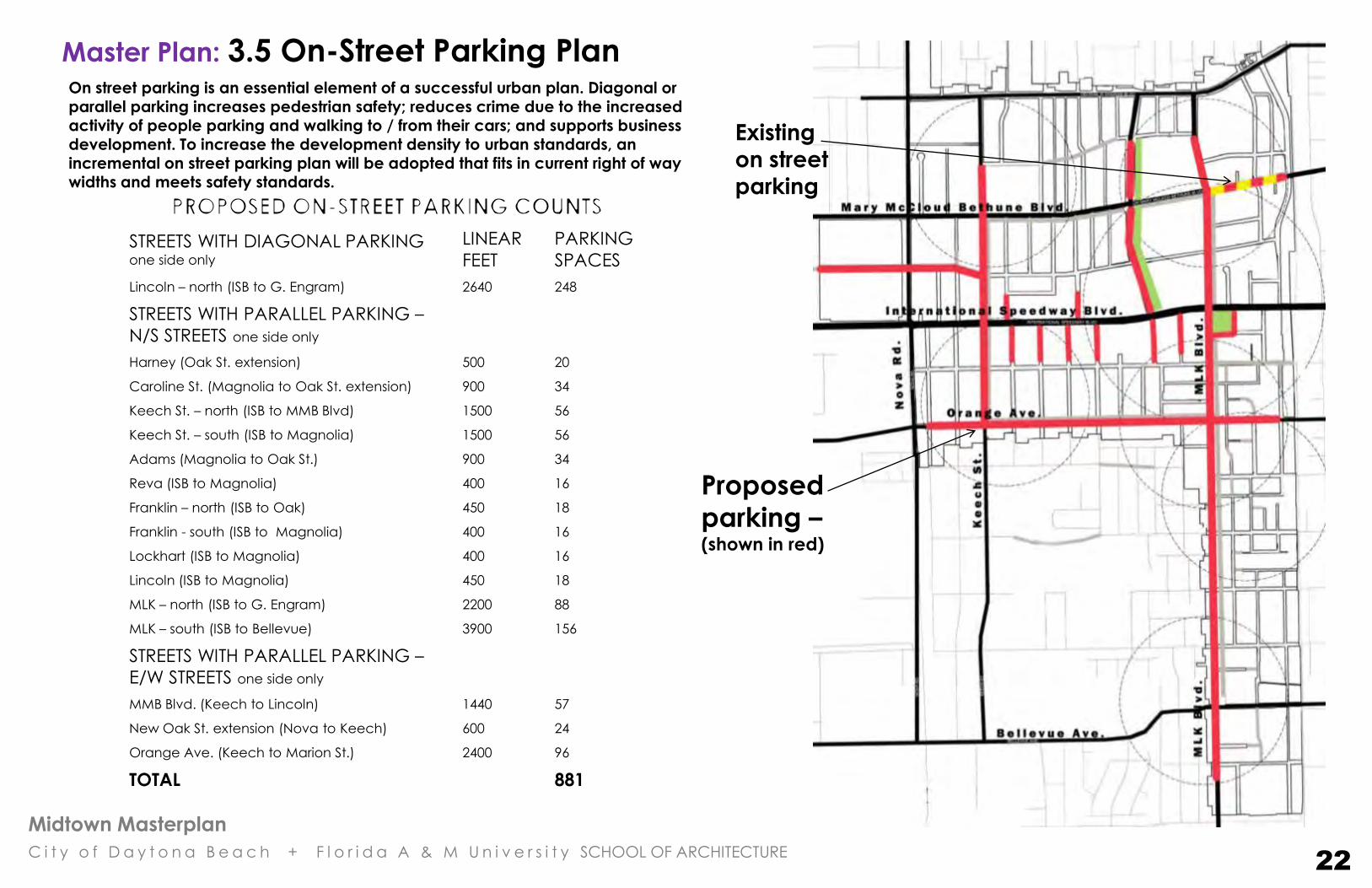
Master Plan: 3.5 On-Street Parking Plan
STREETS WITH DIAGONAL PARKING one side only
LINEAR
FEET
PARKING
SPACES
Lincoln – north (ISB to G. Engram) 2640 248
STREETS WITH PARALLEL PARKING –
N/S STREETS one side only
Harney (Oak St. extension) 500 20
Caroline St. (Magnolia to Oak St. extension) 900 34
Keech St. – north (ISB to MMB Blvd) 1500 56
Keech St. – south (ISB to Magnolia) 1500 56
Adams (Magnolia to Oak St.) 900 34
Reva (ISB to Magnolia) 400 16
Franklin – north (ISB to Oak) 450 18
Franklin - south (ISB to Magnolia) 400 16
Lockhart (ISB to Magnolia) 400 16
Lincoln (ISB to Magnolia) 450 18
MLK – north (ISB to G. Engram) 2200 88
MLK – south (ISB to Bellevue) 3900 156
STREETS WITH PARALLEL PARKING –
E/W STREETS one side only
MMB Blvd. (Keech to Lincoln) 1440 57
New Oak St. extension (Nova to Keech) 600 24
Orange Ave. (Keech to Marion St.) 2400 96
TOTAL 881
Existing
on street
parking
Proposed
parking – (shown in red)
On street parking is an essential element of a successful urban plan. Diagonal or
parallel parking increases pedestrian safety; reduces crime due to the increased activity of people parking and walking to / from their cars; and supports business development. To increase the development density to urban standards, an incremental on street parking plan will be adopted that fits in current right of way widths and meets safety standards.
22
Midtown Masterplan
C i t y o f D a y t o n a B e a c h + F l o r i d a A & M U n i v e r s i t y SCHOOL OF ARCHITECTURE
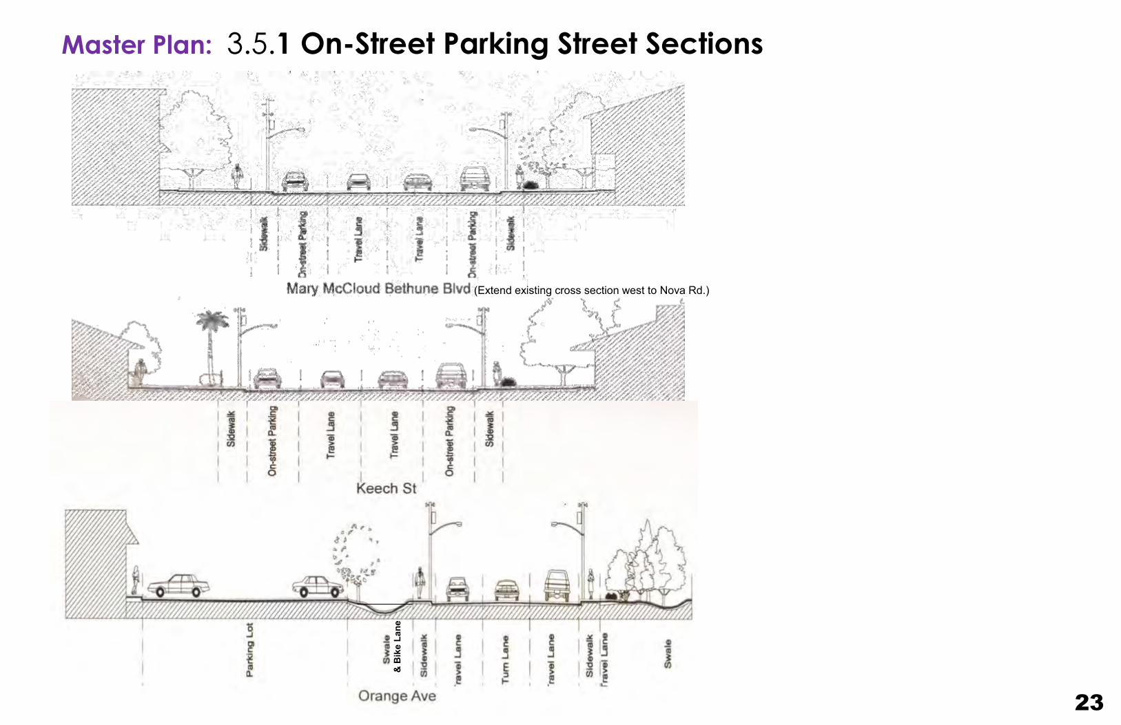
Master Plan: 3.5.1 On-Street Parking Street Sections
23
(Extend existing cross section west to Nova Rd.)
& B
ike
Lane

Midtown Masterplan
C i t y o f D a y t o n a B e a c h + F l o r i d a A & M U n i v e r s i t y SCHOOL OF ARCHITECTURE
Master Plan: 3.6 - Black Heritage Trail, Public Spaces & Monuments Plan
24
Proposed
location
for African
American
Heritage
Center
There are a number of significant historic sites located throughout Midtown. When the proposed Midtown Center
Square is established at the intersection of ISB & MLK Blvd.; It
will be an excellent location for a new African American
Heritage Center. The center will document and present the
important contributions to Civil Rights by the Daytona Beach
Midtown Community, Eatonville and central Florida. The trail
will be marked by themed signage, street lights, pavement
colors and displays that link all of the heritage sites.
The images and Heritage Sites were provided by J. Benderson & the C.O.D.B
Redevelopment Dept.
3
Midtown Masterplan
C i t y o f D a y t o n a B e a c h + F l o r i d a A & M U n i v e r s i t y SCHOOL OF ARCHITECTURE
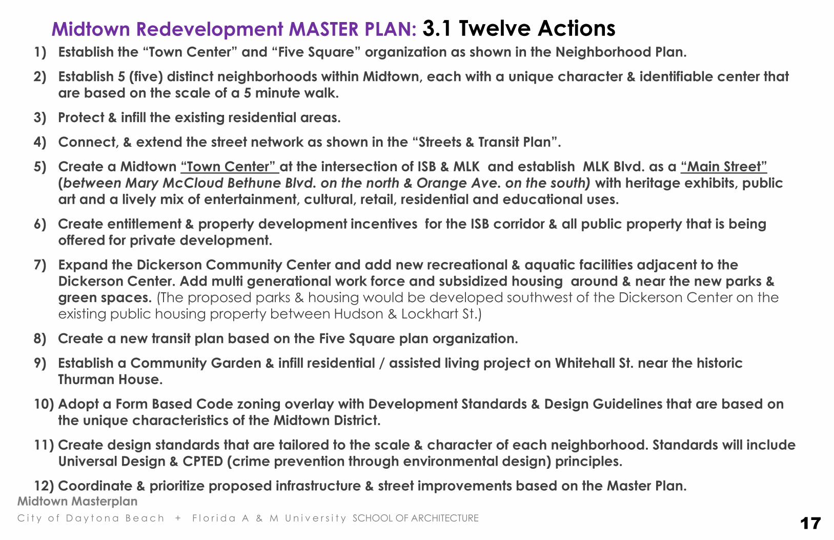
Midtown Redevelopment MASTER PLAN: 3.1 Twelve Actions
1) Establish the “Town Center” and “Five Square” organization as shown in the Neighborhood Plan.
2) Establish 5 (five) distinct neighborhoods within Midtown, each with a unique character & identifiable center that
are based on the scale of a 5 minute walk.
3) Protect & infill the existing residential areas.
4) Connect, & extend the street network as shown in the “Streets & Transit Plan”.
5) Create a Midtown “Town Center” at the intersection of ISB & MLK and establish MLK Blvd. as a “Main Street”
(between Mary McCloud Bethune Blvd. on the north & Orange Ave. on the south) with heritage exhibits, public art and a lively mix of entertainment, cultural, retail, residential and educational uses.
6) Create entitlement & property development incentives for the ISB corridor & all public property that is being
offered for private development.
7) Expand the Dickerson Community Center and add new recreational & aquatic facilities adjacent to the
Dickerson Center. Add multi generational work force and subsidized housing around & near the new parks & green spaces. (The proposed parks & housing would be developed southwest of the Dickerson Center on the existing public housing property between Hudson & Lockhart St.)
8) Create a new transit plan based on the Five Square plan organization.
9) Establish a Community Garden & infill residential / assisted living project on Whitehall St. near the historic
Thurman House.
10) Adopt a Form Based Code zoning overlay with Development Standards & Design Guidelines that are based on
the unique characteristics of the Midtown District.
11) Create design standards that are tailored to the scale & character of each neighborhood. Standards will include
Universal Design & CPTED (crime prevention through environmental design) principles.
12) Coordinate & prioritize proposed infrastructure & street improvements based on the Master Plan.
17
Midtown Masterplan
C i t y o f D a y t o n a B e a c h + F l o r i d a A & M U n i v e r s i t y SCHOOL OF ARCHITECTURE
4. Redevelopment Proposals

Midtown Masterplan
C i t y o f D a y t o n a B e a c h + F l o r i d a A & M U n i v e r s i t y SCHOOL OF ARCHITECTURE
Redevelopment Proposals: 4.1 Redevelopment Focus Areas Plan
3
5
6
8 4
7
10
1
Redevelopment Sites with proposed uses:
1. Midtown Center at ISB & MLK: a mix of university facilities,
mixed use, entertainment & cultural / heritage destinations
2. Huger Park – typical neighborhood center
3. ISB & Nova (vacant car dealership & restaurant), potential uses: hotel / restaurant, grocery or pharmacy
4. ISB infill: misc. commercial & mixed use
5. Daytona Mall, potential uses: large scale discount/grocery,
multi screen theater, Activity Center retail & commercial
6. Oak St Extension: market rate & work force/student housing
7. Lincoln Greenway: landscaped greenway that includes
stormwater / drainage infrastructure and a landscaped
bicycle / pedestrian path
8. City property / police station: mixed use residential, student
housing, magnet school for the arts
9. Dickerson Center Expansion: new community meeting
center, gym & aquatic center; passive & active recreational
fields; new work force, affordable & senior housing
10. City property at the Thurman House: community garden &
small park surrounded by infill & senior housing
11. City utilities site: commercial & eco industrial uses
2
11
9
25

Midtown Masterplan
C i t y o f D a y t o n a B e a c h + F l o r i d a A & M U n i v e r s i t y SCHOOL OF ARCHITECTURE
north
Redevelopment Proposals: 4.2 Midtown Center at ISB and MLK - Site 1
This rendering of the Midtown Center at the intersection of ISB and MLK, shows the scale and uses that are included in the zoning documents.
The plaza functions as a public space to help stitch the university into the fabric of the Midtown community. The dense commercial at ISB
transitions to smaller scale commercial/residential at the Foote St. extension, then transitions down to townhomes and single family homes at
Magnolia Street, complementing the existing homes.
26

Midtown Masterplan
C i t y o f D a y t o n a B e a c h + F l o r i d a A & M U n i v e r s i t y SCHOOL OF ARCHITECTURE
Midtown Square
Mixed-use: Retail, Office, & Residential
Hotel, Restaurant, & Retail
African American Heritage Museum
Theater or Grocery with Retail
Future University Facilities
Parking Garage
Small Commercial
Townhomes, Apartments, & Duplexes
Existing structures
Proposed Uses
north
INTERNATIONAL SPEEDWAY BLVD.
MAGNOLIA ST.. M
LK B
LVD
.
FOOTE ST. EXTENSION
Redevelopment Proposals: 4.2.1 Midtown Center at ISB and MLK - Site 1
legend
27

Midtown Masterplan
C i t y o f D a y t o n a B e a c h + F l o r i d a A & M U n i v e r s i t y SCHOOL OF ARCHITECTURE
PHASE 1
PHASE 2
north PHASE 1: estimated gross square feet = 550,000; additional parking = 1,200 spaces
PHASE 2: estimated gross square feet = 650,000; additional parking = 2,000 spaces
TOTAL GROSS SQUARE FEET = 1,200,000 (estimate) TOTAL PARKING = 3,200 SPACES 375 sq. ft. average per space
Note: Town Center Plaza will be developed after property acquisitions & infrastructure improvements are in place.
INTERNATIONAL SPEEDWAY BLVD.
MAGNOLIA ST..
MLK
BLV
D.
FOOTE ST. EXTENSION
Redevelopment Proposals: 4.2.2 Midtown Center at ISB and MLK - Site 1
Development
Phases
28
BCU
Midtown Masterplan
C i t y o f D a y t o n a B e a c h + F l o r i d a A & M U n i v e r s i t y SCHOOL OF ARCHITECTURE
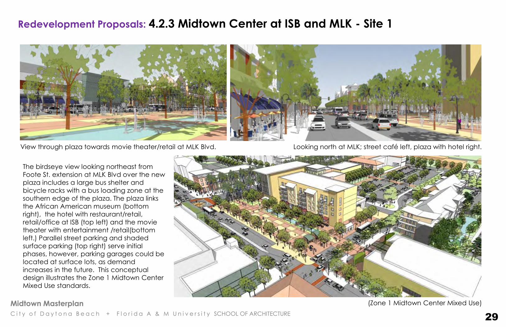
View through plaza towards movie theater/retail at MLK Blvd. Looking north at MLK; street café left, plaza with hotel right.
The birdseye view looking northeast from
Foote St. extension at MLK Blvd over the new
plaza includes a large bus shelter and
bicycle racks with a bus loading zone at the
southern edge of the plaza. The plaza links
the African American museum (bottom
right), the hotel with restaurant/retail,
retail/office at ISB (top left) and the movie
theater with entertainment /retail(bottom
left.) Parallel street parking and shaded
surface parking (top right) serve initial
phases, however, parking garages could be
located at surface lots, as demand
increases in the future. This conceptual
design illustrates the Zone 1 Midtown Center
Mixed Use standards.
(Zone 1 Midtown Center Mixed Use)
Redevelopment Proposals: 4.2.3 Midtown Center at ISB and MLK - Site 1
29
Midtown Masterplan
C i t y o f D a y t o n a B e a c h + F l o r i d a A & M U n i v e r s i t y SCHOOL OF ARCHITECTURE
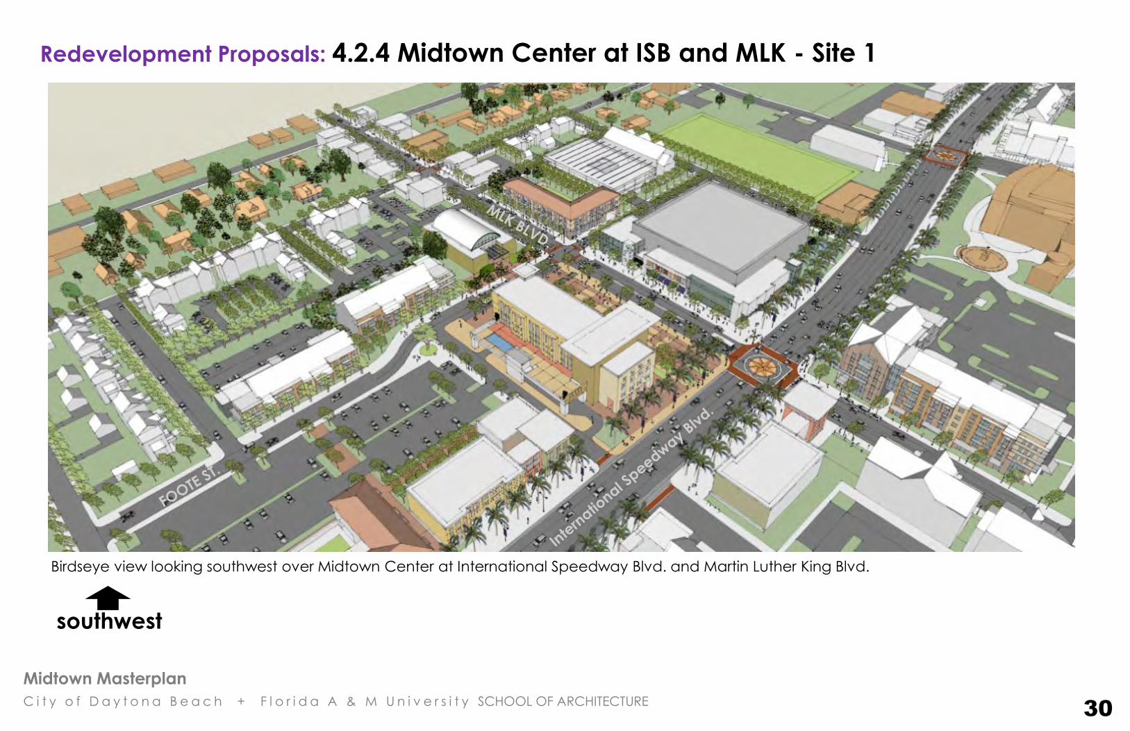
Redevelopment Proposals: 4.2.4 Midtown Center at ISB and MLK - Site 1
Birdseye view looking southwest over Midtown Center at International Speedway Blvd. and Martin Luther King Blvd.
30
southwest

Midtown Masterplan
C i t y o f D a y t o n a B e a c h + F l o r i d a A & M U n i v e r s i t y SCHOOL OF ARCHITECTURE
Looking east into new Plaza. Note street trees and street
lights; awnings and umbrellas provide shade at street café. New buildings shown in white, existing buildings tan. Significant new buildings
have been shown with color for emphasis.
Trees, awnings, umbrellas, and deep arcades provide shade at the
plaza. A mixed-use project is a key factor to the success of the plaza. The water runnel through the plaza is a conceptual axial link
between the university and the community. Paving patterns are
based on textile patterns of African American quilts.
Redevelopment Proposals: 4.2.5 Midtown Center at ISB and MLK - Site 1
31
Midtown Masterplan
C i t y o f D a y t o n a B e a c h + F l o r i d a A & M U n i v e r s i t y SCHOOL OF ARCHITECTURE
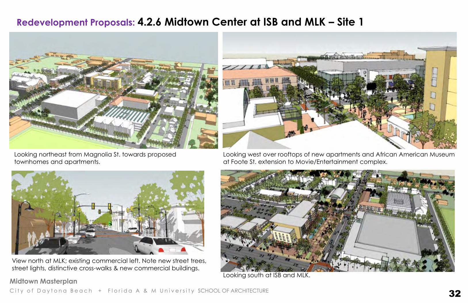
Looking northeast from Magnolia St. towards proposed
townhomes and apartments.
Looking west over rooftops of new apartments and African American Museum
at Foote St. extension to Movie/Entertainment complex.
View north at MLK; existing commercial left. Note new street trees,
street lights, distinctive cross-walks & new commercial buildings. Looking south at ISB and MLK.
Redevelopment Proposals: 4.2.6 Midtown Center at ISB and MLK – Site 1
32
Midtown Masterplan
C i t y o f D a y t o n a B e a c h + F l o r i d a A & M U n i v e r s i t y SCHOOL OF ARCHITECTURE
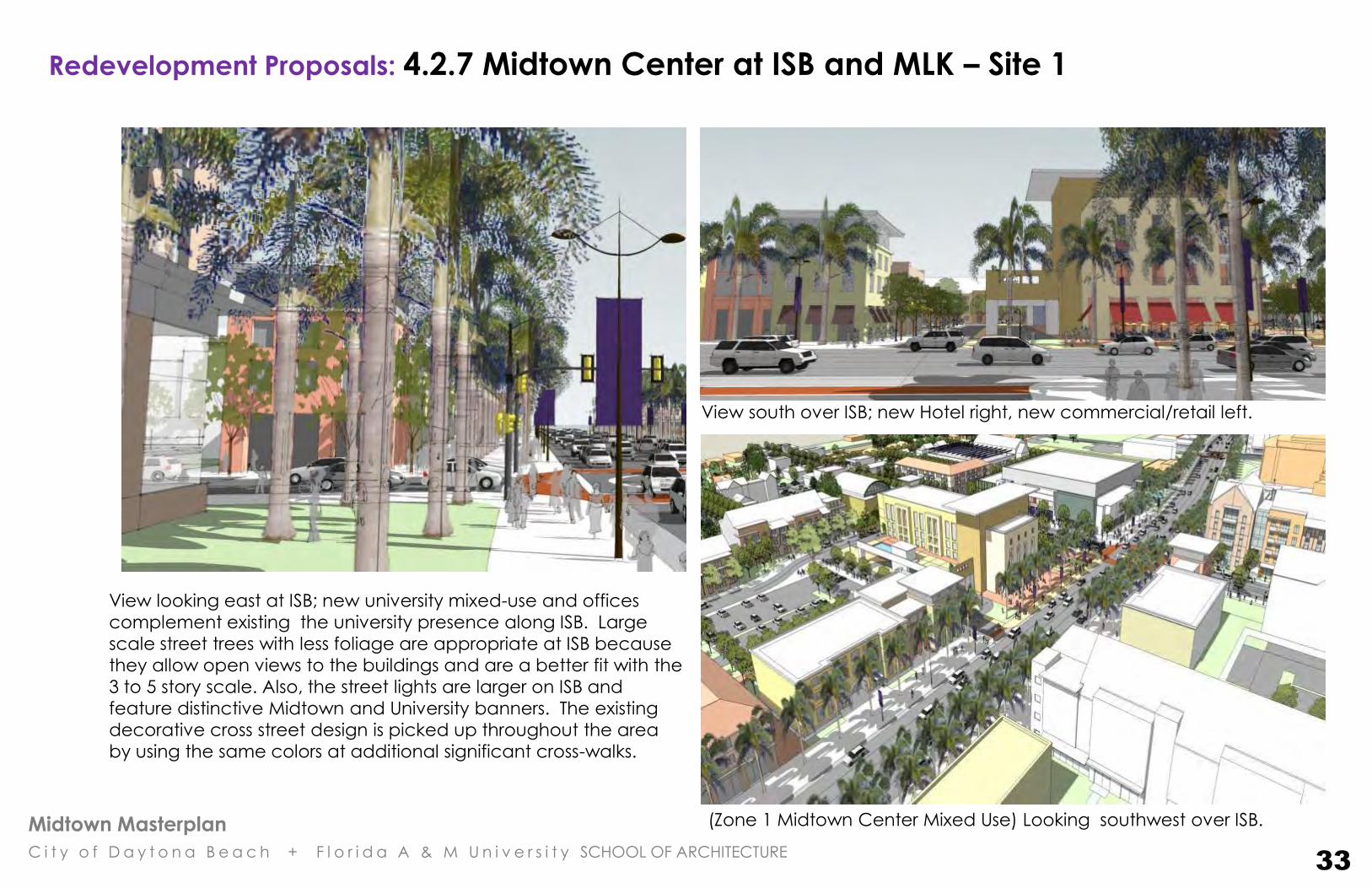
View looking east at ISB; new university mixed-use and offices
complement existing the university presence along ISB. Large
scale street trees with less foliage are appropriate at ISB because
they allow open views to the buildings and are a better fit with the
3 to 5 story scale. Also, the street lights are larger on ISB and
feature distinctive Midtown and University banners. The existing
decorative cross street design is picked up throughout the area
by using the same colors at additional significant cross-walks.
(Zone 1 Midtown Center Mixed Use) Looking southwest over ISB.
View south over ISB; new Hotel right, new commercial/retail left.
Redevelopment Proposals: 4.2.7 Midtown Center at ISB and MLK – Site 1
33
Midtown Masterplan
C i t y o f D a y t o n a B e a c h + F l o r i d a A & M U n i v e r s i t y SCHOOL OF ARCHITECTURE
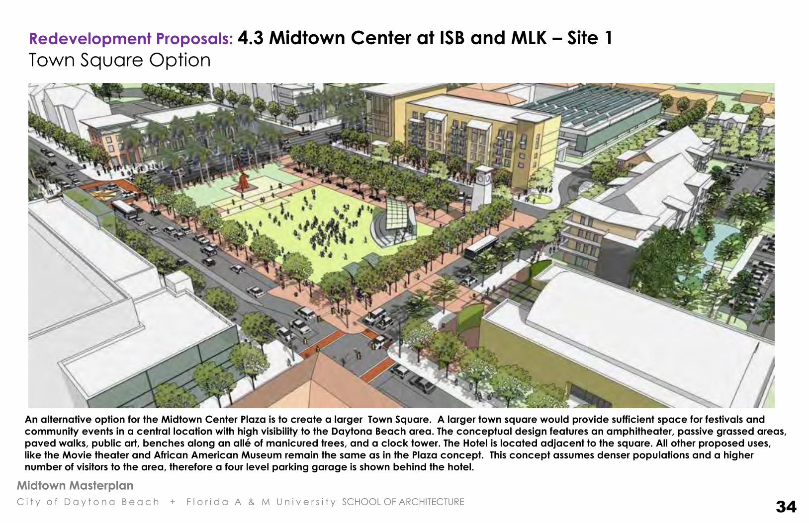
An alternative option for the Midtown Center Plaza is to create a larger Town Square. A larger town square would provide sufficient space for festivals and
community events in a central location with high visibility to the Daytona Beach area. The conceptual design features an amphitheater, passive grassed areas,
paved walks, public art, benches along an allé of manicured trees, and a clock tower. The Hotel is located adjacent to the square. All other proposed uses,
like the Movie theater and African American Museum remain the same as in the Plaza concept. This concept assumes denser populations and a higher
number of visitors to the area, therefore a four level parking garage is shown behind the hotel.
Redevelopment Proposals: 4.3 Midtown Center at ISB and MLK – Site 1
Town Square Option
34
Midtown Masterplan
C i t y o f D a y t o n a B e a c h + F l o r i d a A & M U n i v e r s i t y SCHOOL OF ARCHITECTURE
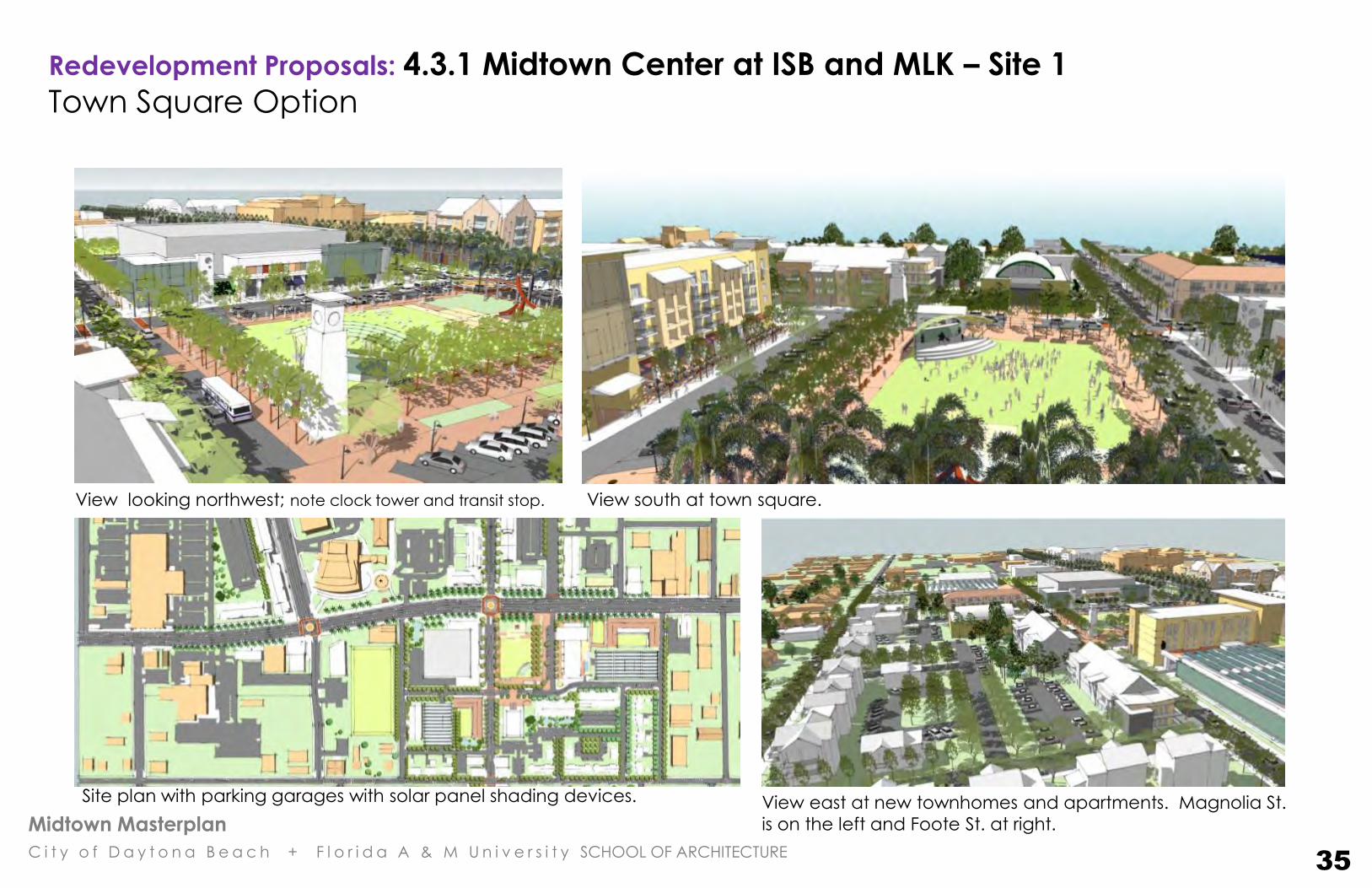
View south at town square. View looking northwest; note clock tower and transit stop.
Site plan with parking garages with solar panel shading devices. View east at new townhomes and apartments. Magnolia St.
is on the left and Foote St. at right.
Redevelopment Proposals: 4.3.1 Midtown Center at ISB and MLK – Site 1
Town Square Option
35

Midtown Masterplan
C i t y o f D a y t o n a B e a c h + F l o r i d a A & M U n i v e r s i t y SCHOOL OF ARCHITECTURE
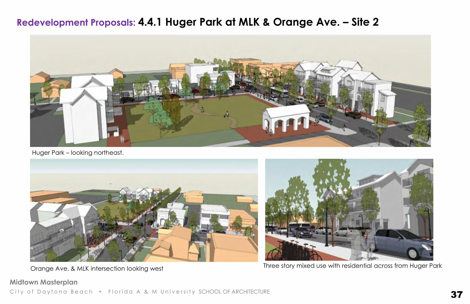
In this neighborhood center (NCMU District 2) at Orange
Ave. and MLK Blvd., Huger Park is defined as a green
public square with the addition of new two & three story,
mixed-use and small commercial buildings (shown in
white). New street trees, street lights, and distinctive
crosswalks continue the midtown identity of the area.
Huger Park looking northeast. Existing buildings shown in peach, new
buildings in white.
Orange Ave. & MLK intersection looking north west
Birdseye view looking southwest at Huger Park, at the
intersection of Orange Ave. and MLK Blvd.
Redevelopment Proposals: 4.4 Huger Park at MLK & Orange Ave. – Site 2
36
Midtown Masterplan
C i t y o f D a y t o n a B e a c h + F l o r i d a A & M U n i v e r s i t y SCHOOL OF ARCHITECTURE
Huger Park – looking northeast.
Orange Ave. & MLK intersection looking west Three story mixed use with residential across from Huger Park
Redevelopment Proposals: 4.4.1 Huger Park at MLK & Orange Ave. – Site 2
37

Midtown Masterplan
C i t y o f D a y t o n a B e a c h + F l o r i d a A & M U n i v e r s i t y SCHOOL OF ARCHITECTURE
Redevelopment Proposals:
4.5 Redevelopment Site 3: Northeast corner of ISB & Nova Rd. This property is strategically located at the intersection of two
major arterial streets. It is an excellent location for national
lodging, restaurant and food service development. The drawing
(shown at left) illustrates a potential site design for a hotel and
restaurant with adequate parking, landscape and stormwater
infrastructure. Both the hotel and restaurant address the street as
required by the Midtown Development Standards District 3.
Site Redevelopment Summary 6.55 acres
Hotel & Meeting Rooms – 5 Floors, 180 Rooms Restaurant – 1 Floor
145,000 s.f.
270 parking spaces
256 s.f. per space
INTERNATIONAL SPEEDWAY BLVD.
NO
VA
RD
.
PROPOSED OAK STREET EXTENSION
Restaurant
38
Midtown Masterplan
C i t y o f D a y t o n a B e a c h + F l o r i d a A & M U n i v e r s i t y SCHOOL OF ARCHITECTURE
Redevelopment Proposals:
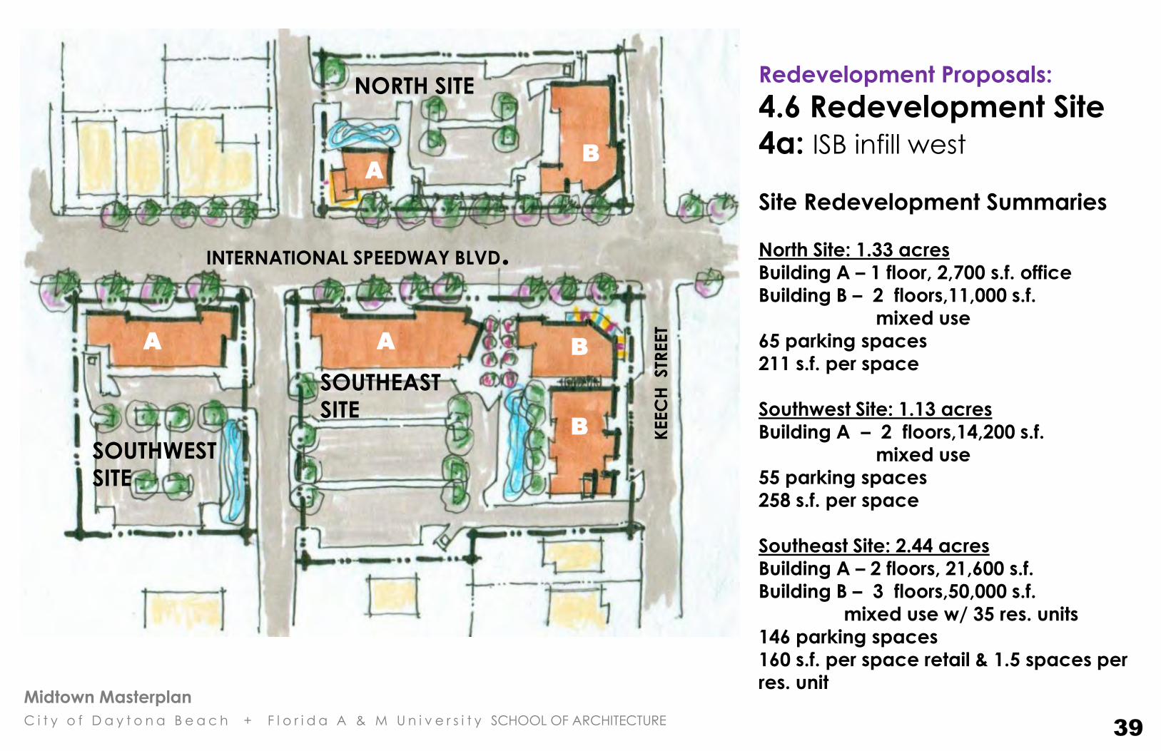
4.6 Redevelopment Site
4a: ISB infill west
Site Redevelopment Summaries
North Site: 1.33 acres Building A – 1 floor, 2,700 s.f. office
Building B – 2 floors,11,000 s.f.
mixed use
65 parking spaces
211 s.f. per space
Southwest Site: 1.13 acres Building A – 2 floors,14,200 s.f.
mixed use
55 parking spaces
258 s.f. per space
Southeast Site: 2.44 acres
Building A – 2 floors, 21,600 s.f.
Building B – 3 floors,50,000 s.f.
mixed use w/ 35 res. units
146 parking spaces 160 s.f. per space retail & 1.5 spaces per
res. unit
A
B
A B A
NORTH SITE
SOUTHWEST
SITE
SOUTHEAST
SITE B
INTERNATIONAL SPEEDWAY BLVD.
KEEC
H STR
EET
39

Midtown Masterplan
C i t y o f D a y t o n a B e a c h + F l o r i d a A & M U n i v e r s i t y SCHOOL OF ARCHITECTURE
Redevelopment
Proposals: 4.7 Redevelopment Site
4b: ISB infill central Site Redevelopment
Summaries Southwest Site: 3.75 acres
Building A – 2 floor garage
townhomes
12 parking spaces
Building B – 2 flrs,16,500 s.f.
mixed use
Building C – 1 flr, 33,200 s.f.
retail
167 parking spaces
297 s.f. per space
Southeast Site: 3.88 acres
Building A – 3 flrs, 100,400 s.f.
mixed use w/
10,400 s.f. ground
flr. retail (@ corners)
& 100 res. units
207 parking spaces 182 s.f. per space retail & 1.5
spaces per res. unit
A
C
A
A A
A
B
SOUTHEAST SITE
SOUTHWEST SITE
ISB A
DA
MS
STR
EET
REV
A
STR
EET
FR
AN
KLI
N
STR
EET
BIO SWALE / STORMWATER POND
40
Midtown Masterplan
C i t y o f D a y t o n a B e a c h + F l o r i d a A & M U n i v e r s i t y SCHOOL OF ARCHITECTURE
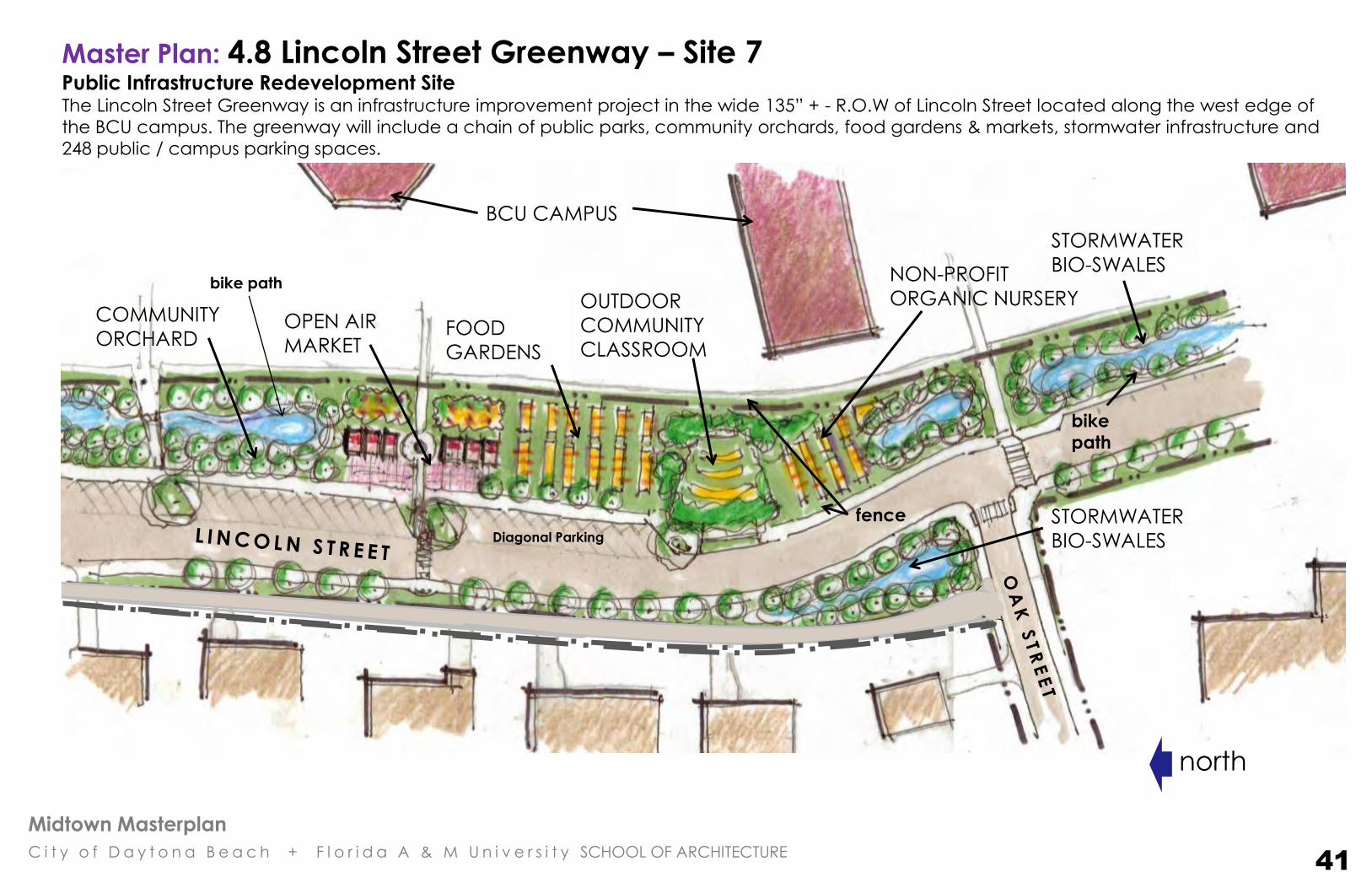
Master Plan: 4.8 Lincoln Street Greenway – Site 7 Public Infrastructure Redevelopment Site The Lincoln Street Greenway is an infrastructure improvement project in the wide 135” + - R.O.W of Lincoln Street located along the west edge of
the BCU campus. The greenway will include a chain of public parks, community orchards, food gardens & markets, stormwater infrastructure and
248 public / campus parking spaces.
STORMWATER
BIO-SWALES
OPEN AIR
MARKET FOOD
GARDENS
NON-PROFIT
ORGANIC NURSERY OUTDOOR
COMMUNITY
CLASSROOM
COMMUNITY
ORCHARD
BCU CAMPUS
fence STORMWATER
BIO-SWALES
bike
path
north
41
bike path
Diagonal Parking
Midtown Masterplan
C i t y o f D a y t o n a B e a c h + F l o r i d a A & M U n i v e r s i t y SCHOOL OF ARCHITECTURE
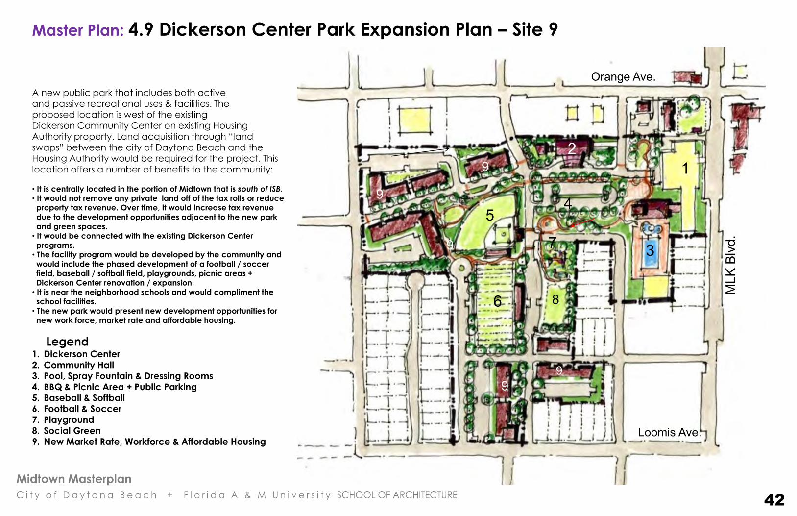
Master Plan: 4.9 Dickerson Center Park Expansion Plan – Site 9
Orange Ave.
MLK
Blv
d.
1 2
3
5
6
4
8
7
Loomis Ave.
A new public park that includes both active and passive recreational uses & facilities. The
proposed location is west of the existing Dickerson Community Center on existing Housing Authority property. Land acquisition through “land swaps” between the city of Daytona Beach and the Housing Authority would be required for the project. This location offers a number of benefits to the community:
• It is centrally located in the portion of Midtown that is south of ISB.
• It would not remove any private land off of the tax rolls or reduce
property tax revenue. Over time, it would increase tax revenue
due to the development opportunities adjacent to the new park
and green spaces.
• It would be connected with the existing Dickerson Center
programs.
• The facility program would be developed by the community and
would include the phased development of a football / soccer
field, baseball / softball field, playgrounds, picnic areas +
Dickerson Center renovation / expansion.
• It is near the neighborhood schools and would compliment the
school facilities.
• The new park would present new development opportunities for
new work force, market rate and affordable housing.
Legend 1. Dickerson Center 2. Community Hall 3. Pool, Spray Fountain & Dressing Rooms 4. BBQ & Picnic Area + Public Parking 5. Baseball & Softball 6. Football & Soccer 7. Playground 8. Social Green
9. New Market Rate, Workforce & Affordable Housing
9
9
9
9
9
42

Midtown Masterplan
C i t y o f D a y t o n a B e a c h + F l o r i d a A & M U n i v e r s i t y SCHOOL OF ARCHITECTURE
Master Plan: 4.10 Thurman Gardens – Site 10 Historic Howard Thurman House & adjacent properties
South Street
Cedar Street
Wh
ite
ha
ll S
tre
et
Ma
rio
n S
tre
et 1
2
3
4
5
Legend 1. Renovated Thurman House
2. Family Center
3. Chapel
4. Community Garden
5. Assisted Living Center
1
The site is located in the southern part of the Midtown community at
Whitehall Street. The railroad tracks are two blocks to the east and
there is a public golf course located a few blocks south of the site. The
historic home of Howard Thurman will be renovated and featured on
the Black Heritage Trail. The surrounding area would be developed as
an urban infill project, in keeping with LEED for Neighborhood
Development, Smart Growth and New Urbanist recommendations. In
addition to the Howard Thurman home there will be a family center,
chapel, community garden, and an assisted living home.
• The majority of this block is currently owned by the city of Daytona Beach. Therefore, it would not remove any private land off of the tax rolls or reduce property tax revenue. Over time, it would increase tax revenue due to the development opportunities adjacent to the new park and green spaces • This location is appropriate for an assisted living and senior housing development because it is in a relatively quiet part of town, yet near to the Bellevue and Huger Park Neighborhood Centers.
• If additional land acquisition is not possible at this location; other possible sites for senior housing are: the site located west of the intersection of Keech St. and Oak St. (where an existing “boarded up” housing complex is scheduled to be demolished) and future sites that would be adjacent to the proposed Dickerson Park Expansion (refer to page 42).
43
Midtown Masterplan
C i t y o f D a y t o n a B e a c h + F l o r i d a A & M U n i v e r s i t y SCHOOL OF ARCHITECTURE
This document supplements the Land Development Regulations for the City of Daytona Beach - Midtown Redevelopment
District. Refer to the LDR for a detailed list of permitted uses and environmental regulations in the district. These
Development Standards & Design Guidelines are specific to the unique characteristics of the Midtown CRA area and
they compliment the Land Development Regulations. All development in the Midtown District is subject to the
requirements herein + all applicable requirements in the Land Development Regulations and the Comprehensive Plan.
5. Development Standards
& Design Guidelines
Midtown Masterplan
C i t y o f D a y t o n a B e a c h + F l o r i d a A & M U n i v e r s i t y SCHOOL OF ARCHITECTURE
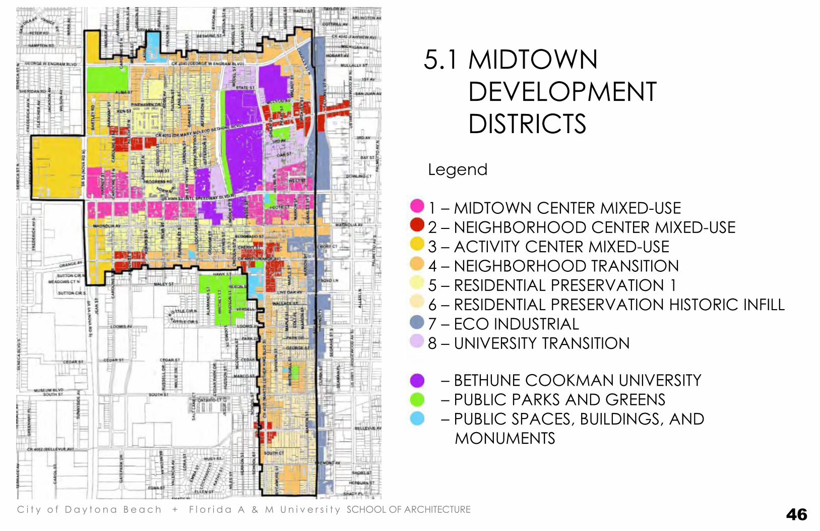
Legend
1 – MIDTOWN CENTER MIXED-USE
2 – NEIGHBORHOOD CENTER MIXED-USE
3 – ACTIVITY CENTER MIXED-USE
4 – NEIGHBORHOOD TRANSITION
5 – RESIDENTIAL PRESERVATION 1
6 – RESIDENTIAL PRESERVATION HISTORIC INFILL
7 – ECO INDUSTRIAL
8 – UNIVERSITY TRANSITION
– BETHUNE COOKMAN UNIVERSITY
– PUBLIC PARKS AND GREENS
– PUBLIC SPACES, BUILDINGS, AND
MONUMENTS
5.1 MIDTOWN
DEVELOPMENT
DISTRICTS
46
Midtown Masterplan
C i t y o f D a y t o n a B e a c h + F l o r i d a A & M U n i v e r s i t y SCHOOL OF ARCHITECTURE 47
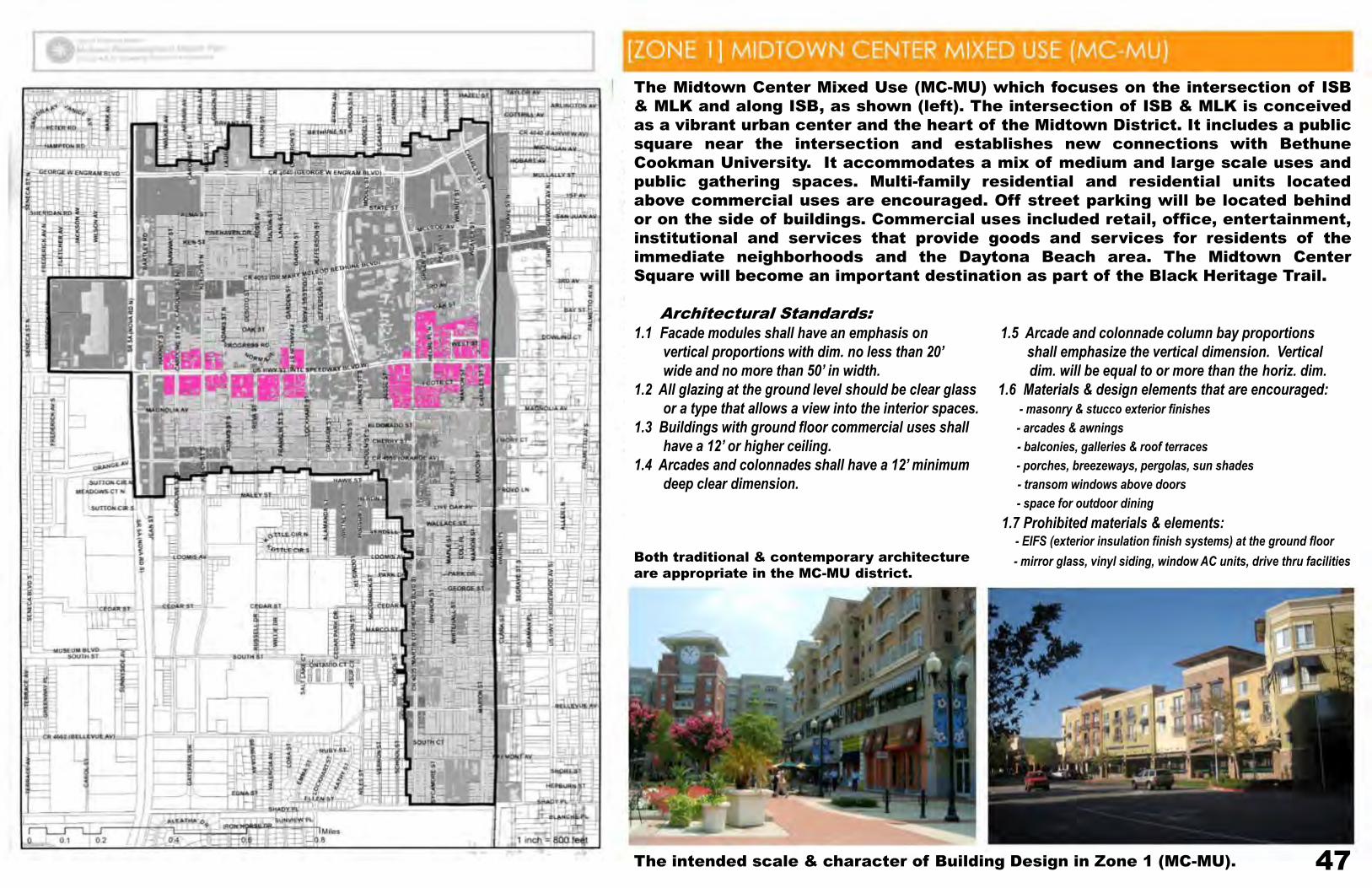
The Midtown Center Mixed Use (MC-MU) which focuses on the intersection of ISB
& MLK and along ISB, as shown (left). The intersection of ISB & MLK is conceived
as a vibrant urban center and the heart of the Midtown District. It includes a public
square near the intersection and establishes new connections with Bethune
Cookman University. It accommodates a mix of medium and large scale uses and
public gathering spaces. Multi-family residential and residential units located
above commercial uses are encouraged. Off street parking will be located behind
or on the side of buildings. Commercial uses included retail, office, entertainment,
institutional and services that provide goods and services for residents of the
immediate neighborhoods and the Daytona Beach area. The Midtown Center
Square will become an important destination as part of the Black Heritage Trail.
Architectural Standards:
1.1 Facade modules shall have an emphasis on 1.5 Arcade and colonnade column bay proportions
vertical proportions with dim. no less than 20’ shall emphasize the vertical dimension. Vertical
wide and no more than 50’ in width. dim. will be equal to or more than the horiz. dim.
1.2 All glazing at the ground level should be clear glass 1.6 Materials & design elements that are encouraged:
or a type that allows a view into the interior spaces. - masonry & stucco exterior finishes
1.3 Buildings with ground floor commercial uses shall - arcades & awnings
have a 12’ or higher ceiling. - balconies, galleries & roof terraces
1.4 Arcades and colonnades shall have a 12’ minimum - porches, breezeways, pergolas, sun shades
deep clear dimension. - transom windows above doors
- space for outdoor dining
1.7 Prohibited materials & elements: - EIFS (exterior insulation finish systems) at the ground floor
- mirror glass, vinyl siding, window AC units, drive thru facilities
The intended scale & character of Building Design in Zone 1 (MC-MU).
Both traditional & contemporary architecture
are appropriate in the MC-MU district.
Midtown Masterplan
C i t y o f D a y t o n a B e a c h + F l o r i d a A & M U n i v e r s i t y SCHOOL OF ARCHITECTURE
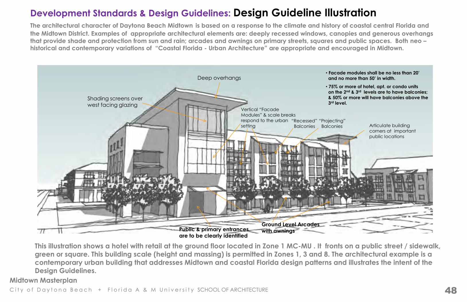
Development Standards & Design Guidelines: Design Guideline Illustration The architectural character of Daytona Beach Midtown is based on a response to the climate and history of coastal central Florida and
the Midtown District. Examples of appropriate architectural elements are: deeply recessed windows, canopies and generous overhangs
that provide shade and protection from sun and rain; arcades and awnings on primary streets, squares and public spaces. Both neo – historical and contemporary variations of “Coastal Florida - Urban Architecture” are appropriate and encouraged in Midtown.
This illustration shows a hotel with retail at the ground floor located in Zone 1 MC-MU . It fronts on a public street / sidewalk,
green or square. This building scale (height and massing) is permitted in Zones 1, 3 and 8. The architectural example is a
contemporary urban building that addresses Midtown and coastal Florida design patterns and illustrates the intent of the
Design Guidelines.
• 75% or more of hotel, apt. or condo units
on the 2nd & 3rd levels are to have balconies;
& 50% or more will have balconies above the
3rd level.
“Recessed”
Balconies
“Projecting”
Balconies
Ground Level Arcades
with awnings
Shading screens over west facing glazing
Deep overhangs
Articulate building
corners at important
public locations
Vertical “Facade
Modules” & scale breaks
respond to the urban
setting
• Facade modules shall be no less than 20’
and no more than 50’ in width.
Public & primary entrances are to be clearly identified
48

Midtown Masterplan
C i t y o f D a y t o n a B e a c h + F l o r i d a A & M U n i v e r s i t y SCHOOL OF ARCHITECTURE
Development Standards & Design Guidelines: Design Guideline Illustration
This illustration shows a retail/office building; it is permitted in Zones 1,2,3,4,7 and 8. The 2nd and 3rd floors could
also include residential uses.
Articulated corner elements (raised heights, extended cornice projections & special roof
forms address public intersections.
Street walls must be varied. Continuous patterns of fenestration & cornice lines may not exceed 50’.
Typical building heights are 2 or 3 stories
Open breezeway at ground level connects the front of the building with off street parking located behind the building.
Plinths & water tables are
encouraged
Articulated entries
are encouraged
Arcades are encouraged
for shade
Clerestories are encouraged
for day lighting
49

Midtown Masterplan
C i t y o f D a y t o n a B e a c h + F l o r i d a A & M U n i v e r s i t y SCHOOL OF ARCHITECTURE 50
PARKING THAT IS LOCATED WITHIN 30’ OF A
REAR OR SIDE PROP. LINE OF EXISTING
RES. USES MUST HAVE AN OPAQUE FENCE
OR HEDGE BETWEEN 4’-8” & 6’ HIGH TO
VISUALLY SCREEN THE PARKING AREA.
2 STORY MINIMUM (EXCEPT FOR LARGE ASSEMBLY USES)
5 STOREY MAXIMUM
50’
(ON THE PRIMARY STREET FRONTAGE)
SECONDARY STREETS – SAME AS BUILDINGS (SHOWN ABOVE)
80 / ACRE
75% *
Development Standards

Midtown Masterplan
C i t y o f D a y t o n a B e a c h + F l o r i d a A & M U n i v e r s i t y SCHOOL OF ARCHITECTURE 51
ISB Blvd.
New Buildings Parking & service

Midtown Masterplan
C i t y o f D a y t o n a B e a c h + F l o r i d a A & M U n i v e r s i t y SCHOOL OF ARCHITECTURE
52
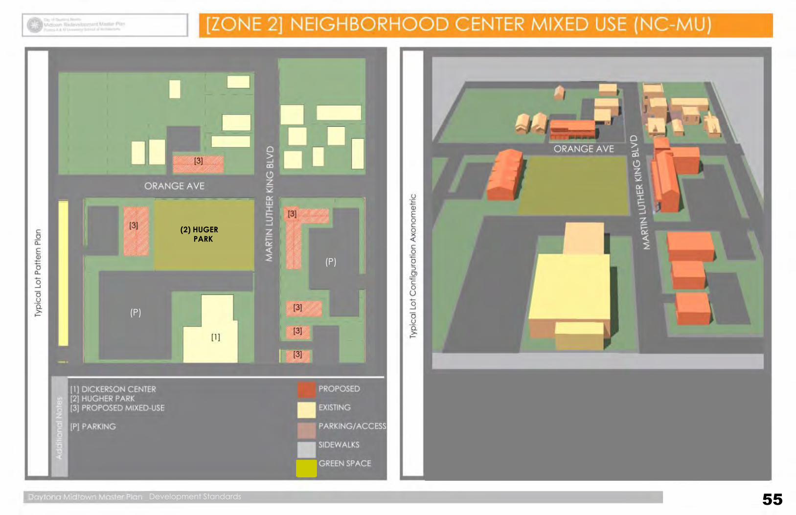
The Neighborhood Center Mixed-Use (NC-MU) is established to accommodate a mix
of residential and small-scale, low-intensity, and “convenience” retail and services
that provide goods/services to residents of the immediate neighborhood (i.e.
personal services, restaurants, and limited retail.)
Development in the district should not include uses of a size that is out of scale with
a residential neighborhood. Residential uses are encouraged on the upper floors of
nonresidential establishments. The district is subject to standards intended to
ensure development is consistent with the neighborhood scale and compatible with
the surrounding uses.
Architectural Standards:
2.1 Facade modules shall have an emphasis on 2.5 Arcade and colonnade column bay proportions
vertical proportions with dim. no less than 20’ shall emphasize the vertical dimension. Vertical
wide and no more than 40’ in width. dim. will be equal to or more than the horiz. dim.
2.2 All glazing at the ground level should be clear glass 2.6 Materials & design elements that are encouraged:
or a type that allows a view into the interior spaces. - masonry , stucco, cementitious siding & metal ext. finishes
2.3 Buildings with ground floor commercial uses shall - arcades & awnings
have a 12’ or higher ceiling. - balconies, galleries & roof terraces
2.4 Arcades and colonnades shall have a 10’ minimum - porches, breezeways, pergolas, sun shades
deep clear dimension. - transom windows above doors
- space for outdoor dining
2.7 Prohibited materials & elements: - EIFS (exterior insulation finish systems) at the ground floor
- mirror glass, vinyl siding, window AC units, drive thru facilities
The intended scale & character of Building Design in Zone 2 (NC-MU).
Midtown Masterplan
C i t y o f D a y t o n a B e a c h + F l o r i d a A & M U n i v e r s i t y SCHOOL OF ARCHITECTURE
Development Standards & Design Guidelines: Design Guideline Illustration
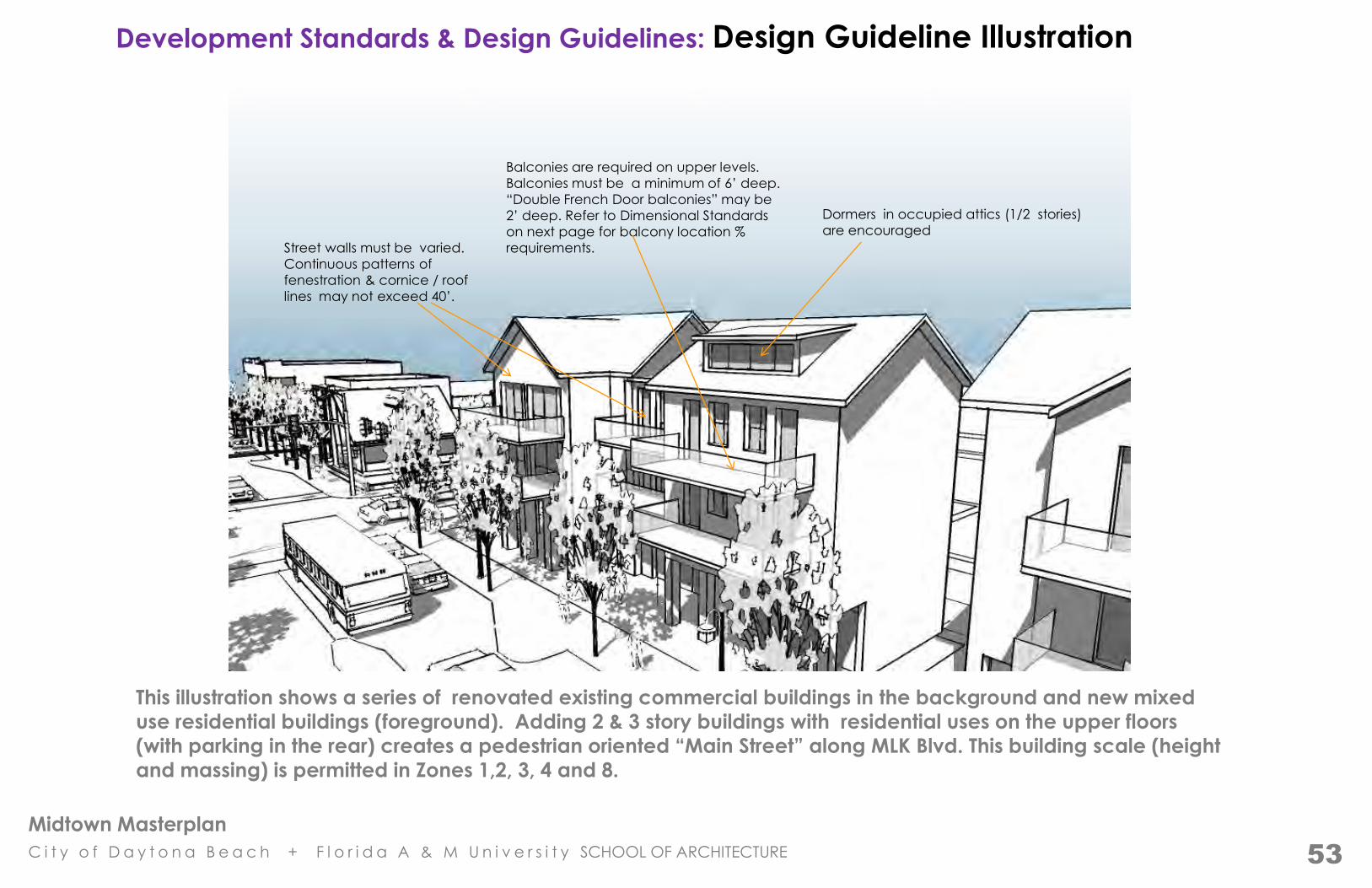
This illustration shows a series of renovated existing commercial buildings in the background and new mixed
use residential buildings (foreground). Adding 2 & 3 story buildings with residential uses on the upper floors
(with parking in the rear) creates a pedestrian oriented “Main Street” along MLK Blvd. This building scale (height
and massing) is permitted in Zones 1,2, 3, 4 and 8.
Dormers in occupied attics (1/2 stories)
are encouraged
Balconies are required on upper levels.
Balconies must be a minimum of 6’ deep.
“Double French Door balconies” may be
2’ deep. Refer to Dimensional Standards
on next page for balcony location %
requirements.
Street walls must be varied.
Continuous patterns of
fenestration & cornice / roof
lines may not exceed 40’.
53

Midtown Masterplan
C i t y o f D a y t o n a B e a c h + F l o r i d a A & M U n i v e r s i t y SCHOOL OF ARCHITECTURE 54
PARKING THAT IS LOCATED WITHIN
30’ OF A REAR OR SIDE PROP. LINE
NEXT TO EXISTING RES.IDENTIAL
USES MUST HAVE AN OPAQUE
FENCE OR HEDGE BETWEEN 4’-8”
& 6’ HIGH TO VISUALLY SCREEN
THE PARKING AREA.
40 / ACRE
40’
Midtown Masterplan
C i t y o f D a y t o n a B e a c h + F l o r i d a A & M U n i v e r s i t y SCHOOL OF ARCHITECTURE 55
(P)
(P)
(2) HUGER
PARK
Development Standards 55
Midtown Masterplan
C i t y o f D a y t o n a B e a c h + F l o r i d a A & M U n i v e r s i t y SCHOOL OF ARCHITECTURE
56
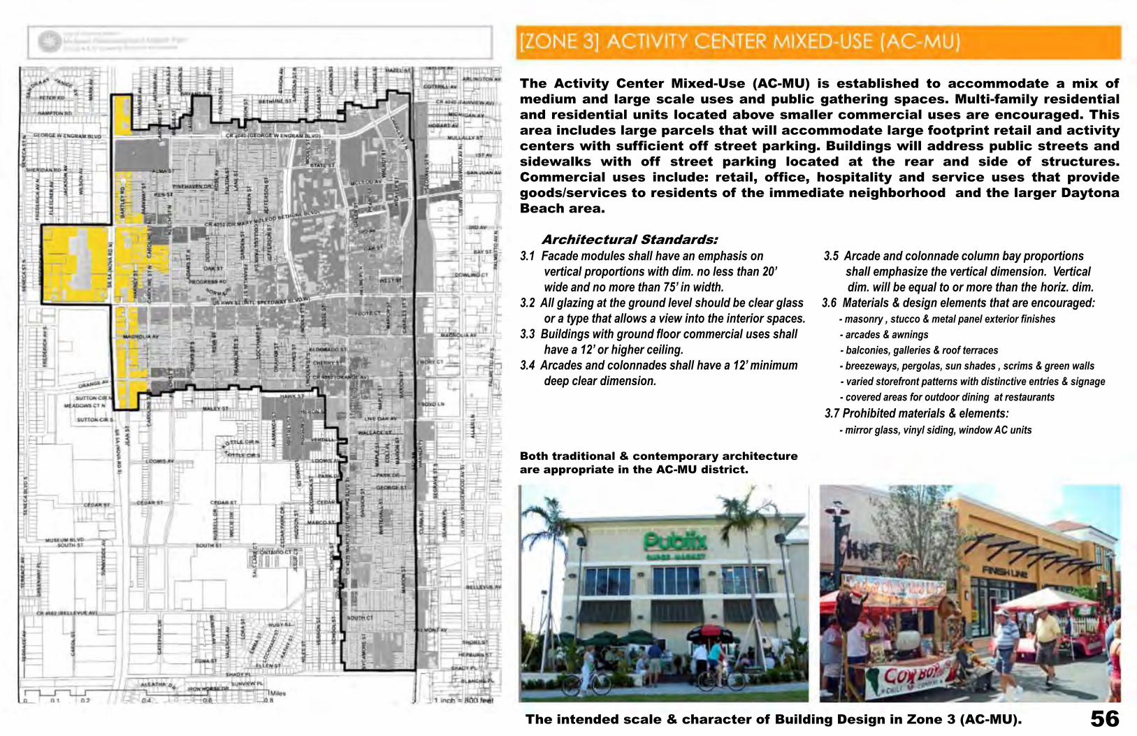
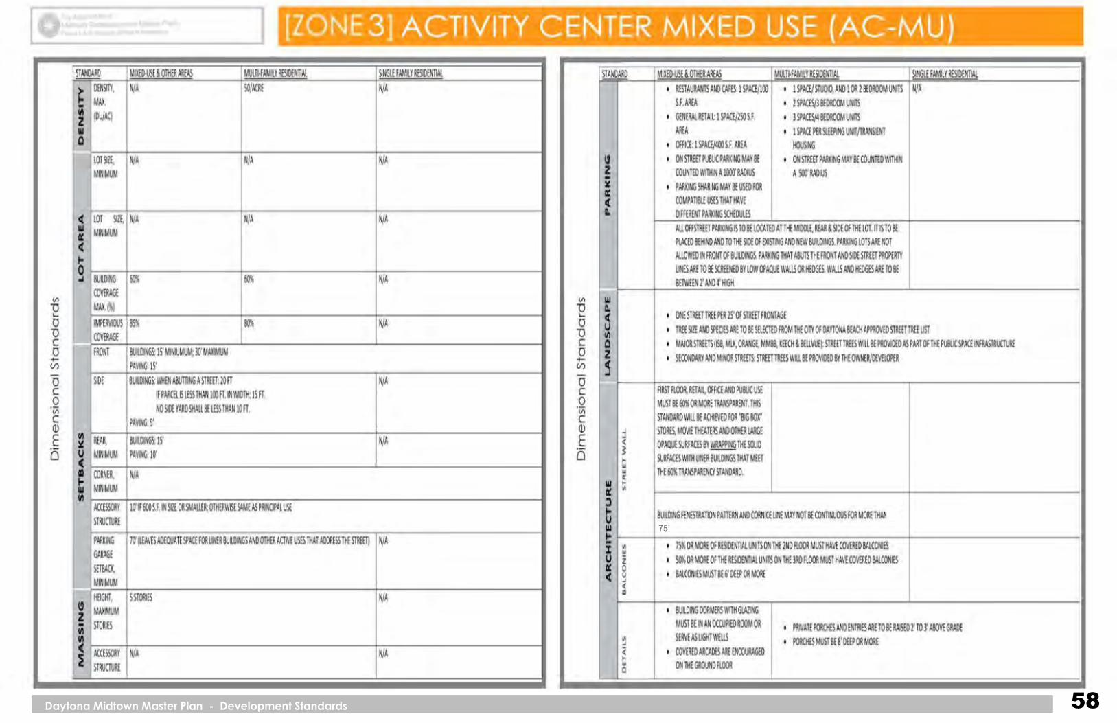
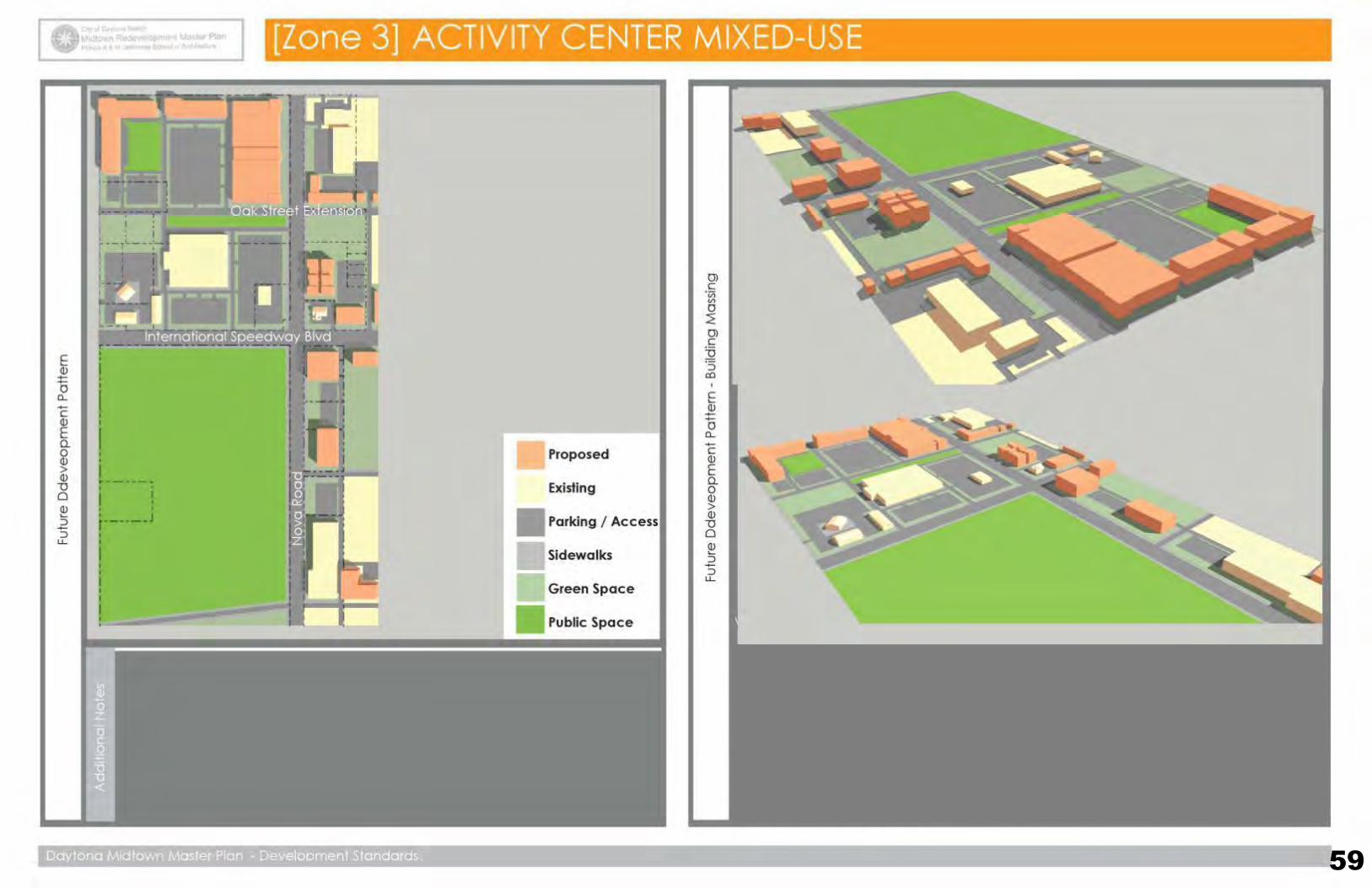
The Activity Center Mixed-Use (AC-MU) is established to accommodate a mix of
medium and large scale uses and public gathering spaces. Multi-family residential
and residential units located above smaller commercial uses are encouraged. This
area includes large parcels that will accommodate large footprint retail and activity
centers with sufficient off street parking. Buildings will address public streets and
sidewalks with off street parking located at the rear and side of structures.
Commercial uses include: retail, office, hospitality and service uses that provide
goods/services to residents of the immediate neighborhood and the larger Daytona
Beach area.
Architectural Standards:
3.1 Facade modules shall have an emphasis on 3.5 Arcade and colonnade column bay proportions
vertical proportions with dim. no less than 20’ shall emphasize the vertical dimension. Vertical
wide and no more than 75’ in width. dim. will be equal to or more than the horiz. dim.
3.2 All glazing at the ground level should be clear glass 3.6 Materials & design elements that are encouraged:
or a type that allows a view into the interior spaces. - masonry , stucco & metal panel exterior finishes
3.3 Buildings with ground floor commercial uses shall - arcades & awnings
have a 12’ or higher ceiling. - balconies, galleries & roof terraces
3.4 Arcades and colonnades shall have a 12’ minimum - breezeways, pergolas, sun shades , scrims & green walls
deep clear dimension. - varied storefront patterns with distinctive entries & signage
- covered areas for outdoor dining at restaurants
3.7 Prohibited materials & elements:
- mirror glass, vinyl siding, window AC units
Both traditional & contemporary architecture
are appropriate in the AC-MU district.
The intended scale & character of Building Design in Zone 3 (AC-MU).

Midtown Masterplan
C i t y o f D a y t o n a B e a c h + F l o r i d a A & M U n i v e r s i t y SCHOOL OF ARCHITECTURE
Development Standards & Design Guidelines: Design Guideline Illustration
This illustration shows a movie theater wrapped with a liner building that includes transparency at the pedestrian
scale. Large “Big Box” buildings with featureless blank facades must be wrapped on at least two (2) sides with
pedestrian scaled elements that address the street and sidewalk. This building scale (height and massing) is
permitted in Zones 1 and 3.
Transparency at street level Transparent enclosure around vertical circulation
Awnings and storefronts at street level
Inventive design elements
are encouraged adjacent
to public spaces .
57
Midtown Masterplan
C i t y o f D a y t o n a B e a c h + F l o r i d a A & M U n i v e r s i t y SCHOOL OF ARCHITECTURE 58
75’
75’
Daytona Midtown Master Plan - Development Standards
Midtown Masterplan
C i t y o f D a y t o n a B e a c h + F l o r i d a A & M U n i v e r s i t y SCHOOL OF ARCHITECTURE 59
Midtown Masterplan
C i t y o f D a y t o n a B e a c h + F l o r i d a A & M U n i v e r s i t y SCHOOL OF ARCHITECTURE 60
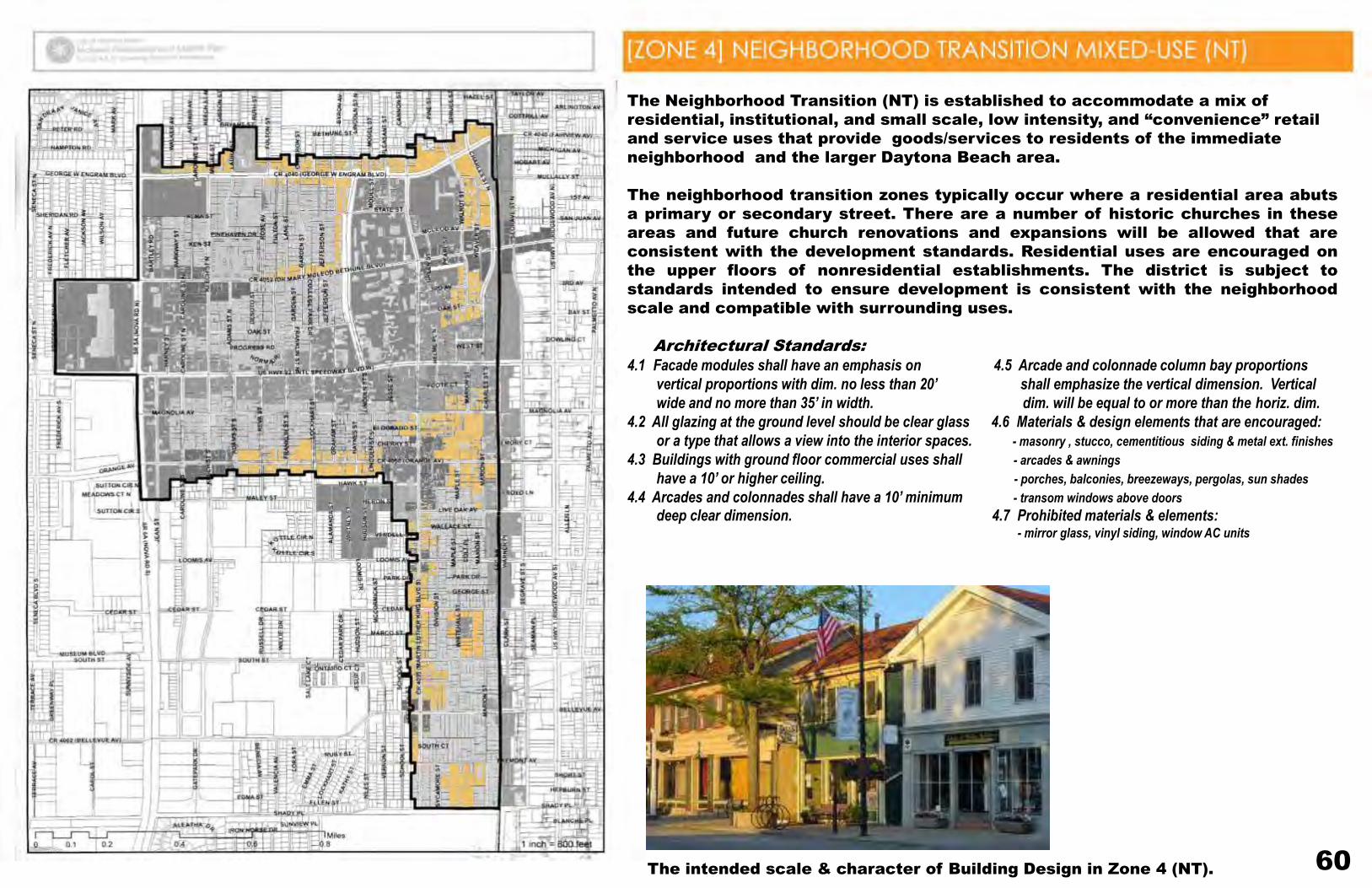
The Neighborhood Transition (NT) is established to accommodate a mix of
residential, institutional, and small scale, low intensity, and “convenience” retail
and service uses that provide goods/services to residents of the immediate
neighborhood and the larger Daytona Beach area.
The neighborhood transition zones typically occur where a residential area abuts
a primary or secondary street. There are a number of historic churches in these
areas and future church renovations and expansions will be allowed that are
consistent with the development standards. Residential uses are encouraged on
the upper floors of nonresidential establishments. The district is subject to
standards intended to ensure development is consistent with the neighborhood
scale and compatible with surrounding uses.
Architectural Standards:
4.1 Facade modules shall have an emphasis on 4.5 Arcade and colonnade column bay proportions
vertical proportions with dim. no less than 20’ shall emphasize the vertical dimension. Vertical
wide and no more than 35’ in width. dim. will be equal to or more than the horiz. dim.
4.2 All glazing at the ground level should be clear glass 4.6 Materials & design elements that are encouraged:
or a type that allows a view into the interior spaces. - masonry , stucco, cementitious siding & metal ext. finishes
4.3 Buildings with ground floor commercial uses shall - arcades & awnings
have a 10’ or higher ceiling. - porches, balconies, breezeways, pergolas, sun shades
4.4 Arcades and colonnades shall have a 10’ minimum - transom windows above doors
deep clear dimension. 4.7 Prohibited materials & elements: - mirror glass, vinyl siding, window AC units
The intended scale & character of Building Design in Zone 4 (NT).
Midtown Masterplan
C i t y o f D a y t o n a B e a c h + F l o r i d a A & M U n i v e r s i t y SCHOOL OF ARCHITECTURE
Development Standards & Design Guidelines: Design Guideline Illustration
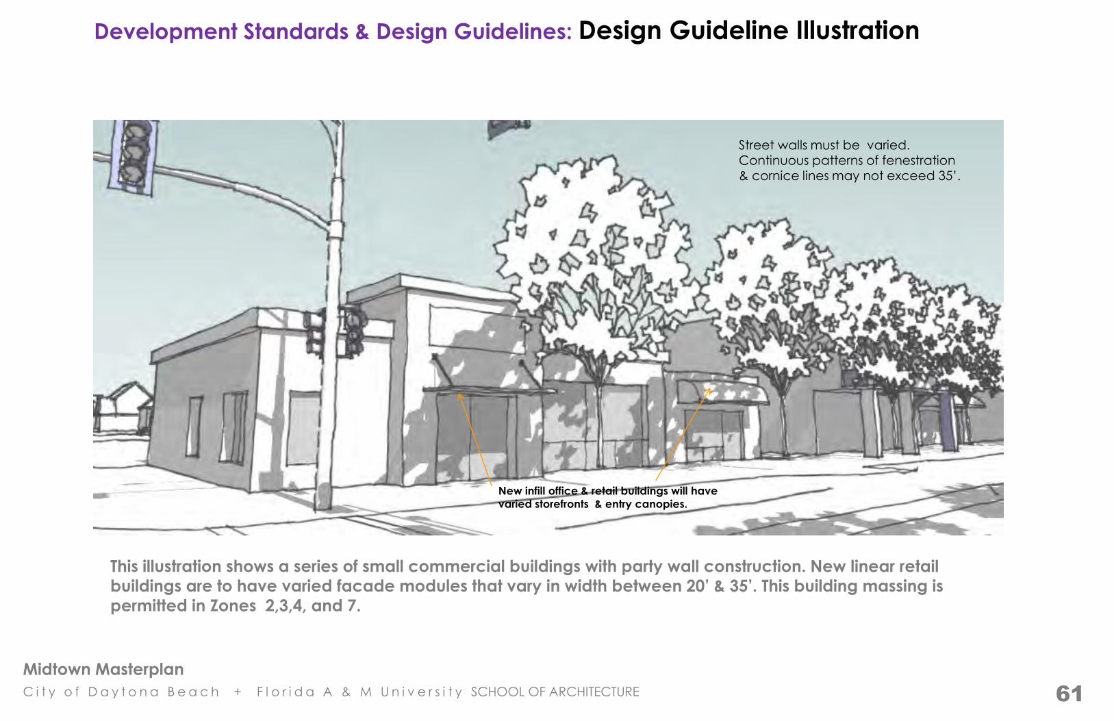
This illustration shows a series of small commercial buildings with party wall construction. New linear retail
buildings are to have varied facade modules that vary in width between 20’ & 35’. This building massing is
permitted in Zones 2,3,4, and 7.
Street walls must be varied.
Continuous patterns of fenestration & cornice lines may not exceed 35’.
New infill office & retail buildings will have
varied storefronts & entry canopies.
61
Midtown Masterplan
C i t y o f D a y t o n a B e a c h + F l o r i d a A & M U n i v e r s i t y SCHOOL OF ARCHITECTURE
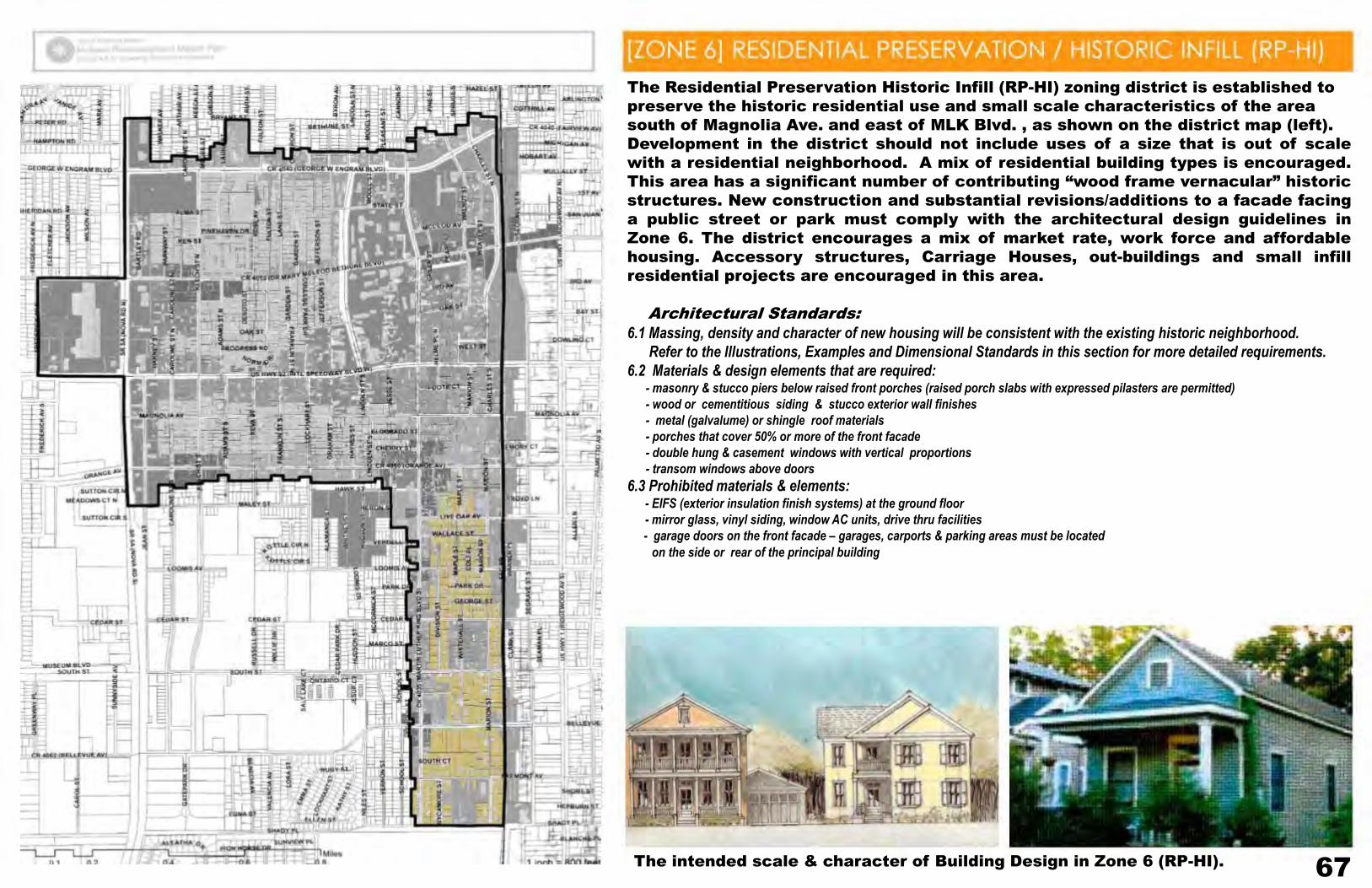
67
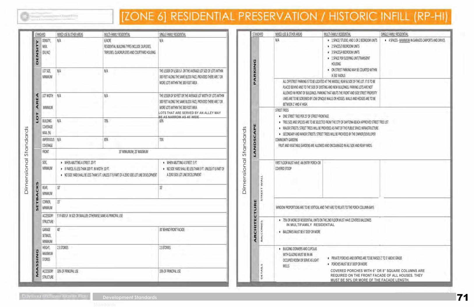
The Residential Preservation Historic Infill (RP-HI) zoning district is established to
preserve the historic residential use and small scale characteristics of the area
south of Magnolia Ave. and east of MLK Blvd. , as shown on the district map (left).
Development in the district should not include uses of a size that is out of scale
with a residential neighborhood. A mix of residential building types is encouraged.
This area has a significant number of contributing “wood frame vernacular” historic
structures. New construction and substantial revisions/additions to a facade facing
a public street or park must comply with the architectural design guidelines in
Zone 6. The district encourages a mix of market rate, work force and affordable
housing. Accessory structures, Carriage Houses, out-buildings and small infill
residential projects are encouraged in this area.
Architectural Standards:
6.1 Massing, density and character of new housing will be consistent with the existing historic neighborhood.
Refer to the Illustrations, Examples and Dimensional Standards in this section for more detailed requirements.
6.2 Materials & design elements that are required: - masonry & stucco piers below raised front porches (raised porch slabs with expressed pilasters are permitted)
- wood or cementitious siding & stucco exterior wall finishes
- metal (galvalume) or shingle roof materials
- porches that cover 50% or more of the front facade
- double hung & casement windows with vertical proportions
- transom windows above doors
6.3 Prohibited materials & elements: - EIFS (exterior insulation finish systems) at the ground floor
- mirror glass, vinyl siding, window AC units, drive thru facilities
- garage doors on the front facade – garages, carports & parking areas must be located
on the side or rear of the principal building
The intended scale & character of Building Design in Zone 6 (RP-HI).
Midtown Masterplan
C i t y o f D a y t o n a B e a c h + F l o r i d a A & M U n i v e r s i t y SCHOOL OF ARCHITECTURE
Development Standards & Design Guidelines: Design Guideline Illustration
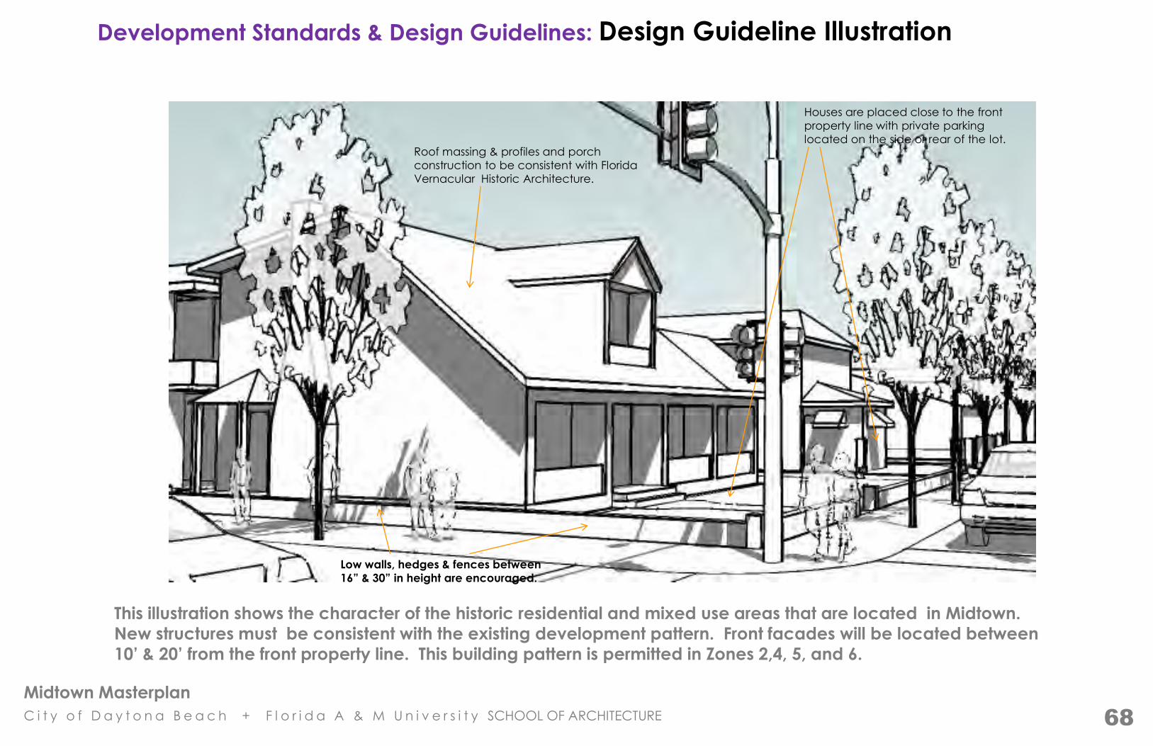
This illustration shows the character of the historic residential and mixed use areas that are located in Midtown.
New structures must be consistent with the existing development pattern. Front facades will be located between
10’ & 20’ from the front property line. This building pattern is permitted in Zones 2,4, 5, and 6.
Low walls, hedges & fences between
16” & 30” in height are encouraged.
Roof massing & profiles and porch
construction to be consistent with Florida
Vernacular Historic Architecture.
Houses are placed close to the front
property line with private parking
located on the side or rear of the lot.
68
Midtown Masterplan
C i t y o f D a y t o n a B e a c h + F l o r i d a A & M U n i v e r s i t y SCHOOL OF ARCHITECTURE
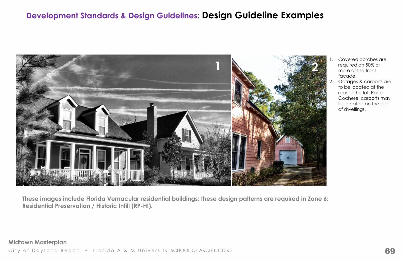
Development Standards & Design Guidelines: Design Guideline Examples
These images include Florida Vernacular residential buildings; these design patterns are required in Zone 6:
Residential Preservation / Historic Infill (RP-HI).
1 2 1. Covered porches are
required on 50% or more of the front facade.
2. Garages & carports are
to be located at the rear of the lot. Porte Cochere carports may be located on the side of dwellings.
69

Midtown Masterplan
C i t y o f D a y t o n a B e a c h + F l o r i d a A & M U n i v e r s i t y SCHOOL OF ARCHITECTURE
Development Standards & Design Guidelines: Design Guideline Examples
These images show a series of Florida Vernacular residential buildings; these design patterns are required in Zone 6:
Residential Preservation / Historic Infill (RP-HI).
1
2
3
4
5
6
1. Attic stories are encouraged. 2. Dormers must have operable windows and be located in occupied spaces. 3. Fireplaces & chimneys are encouraged.
4. In private buildings, 1st floor elevations are to be raised 24” to 36” above grade. 5. Window & column bay proportions shall emphasize the vertical dimension. Vertical dimensions will be equal to or greater than the horizontal dimension.
6. Window & door shutters are to be operable & proportioned to match the opening.
70
Midtown Masterplan
C i t y o f D a y t o n a B e a c h + F l o r i d a A & M U n i v e r s i t y SCHOOL OF ARCHITECTURE 71
Developme
nt
Standards
Development Standards
LOTS THAT ARE SERVED BY AN ALLEY MAY
BE AS NARROW AS 40’ WIDE
IN MULTIFAMILY RESIDENTIAL
COVERED PORCHES WITH 6” OR 8” SQUARE COLUMNS ARE
REQUIRED ON THE FRONT FACADE OF ALL HOUSES. THEY
MUST BE 50% OR MORE OF THE FACADE LENGTH.
Midtown Masterplan
C i t y o f D a y t o n a B e a c h + F l o r i d a A & M U n i v e r s i t y SCHOOL OF ARCHITECTURE 72

Midtown Masterplan
C i t y o f D a y t o n a B e a c h + F l o r i d a A & M U n i v e r s i t y SCHOOL OF ARCHITECTURE
73
The Eco-Industrial (ECI) zoning district is centered on the railroad track along the
eastern edge of Midtown, as shown on the district map (left). There are a number
of existing light industrial uses in the area that will remain. The district encourages
new business and light industry that is based on ecologically sensitive models of
business operation and production.
Due to its central location in the city, there are opportunities for “green”
manufacturing, storage and distribution. Art studios, laboratories and research
uses associated with the numerous colleges and universities in the area are also
encouraged.
Architectural Standards:
7.1 Service yards and outdoor storage areas must be completely enclosed or screened from view.
*Also refer to the C.O.D.B. Land Development Code for applicable environmental standards
regarding industrial operations, noise levels, particulate levels, materials storage and disposal.
The intended scale & character of Building Design in Zone 7 (ECI).

Midtown Masterplan
C i t y o f D a y t o n a B e a c h + F l o r i d a A & M U n i v e r s i t y SCHOOL OF ARCHITECTURE
76
The University Transition (UT) zoning is established to accommodate a mix of
residential, institutional/religious and small scale, low intensity, and “convenience”
retail and service uses that support and compliment Bethune Cookman University.
Residential uses are encouraged on the upper floors of nonresidential
establishments. The district also includes areas that are appropriate for university
expansion. The district includes standards intended to ensure that development is
consistent with the scale and quality of the BCU campus and compatible with
surrounding uses. The BCU and Midtown master plans create an opportunity to
connect the campus and community as they both grow and change. The expansion of
campus facilities and related campus services to the east will also establish an
improved market for the shops and stores located on Mary McCloud Bethune Blvd
(east of campus).
Architectural Standards:
8.1 Facade modules shall have an emphasis on 8.5 Arcade and colonnade column bay proportions
vertical proportions with dim. no less than 20’ shall emphasize the vertical dimension. Vertical
wide and no more than 50’ in width. dim. will be equal to or more than the horiz. dim.
8.2 All glazing at the ground level should be clear glass 8.6 Materials & design elements that are encouraged:
(for retail uses) that allows a view into the interior. - masonry & stucco exterior finishes
8.3 Buildings with ground floor commercial uses shall - arcades & awnings
have a 12’ or higher ceiling. - balconies, galleries & roof terraces
8.4 Arcades and colonnades shall have a 10’ minimum - porches, breezeways, pergolas, sun shades
deep clear dimension. - transom windows above doors
- space for outdoor dining
8.7 Prohibited materials & elements: - EIFS (exterior insulation finish systems) at the ground floor
- mirror glass, vinyl siding, window AC units, drive thru facilities
Both traditional & contemporary architecture are appropriate in the UT district.
The intended scale & character of Building Design in Zone 8 (UT).
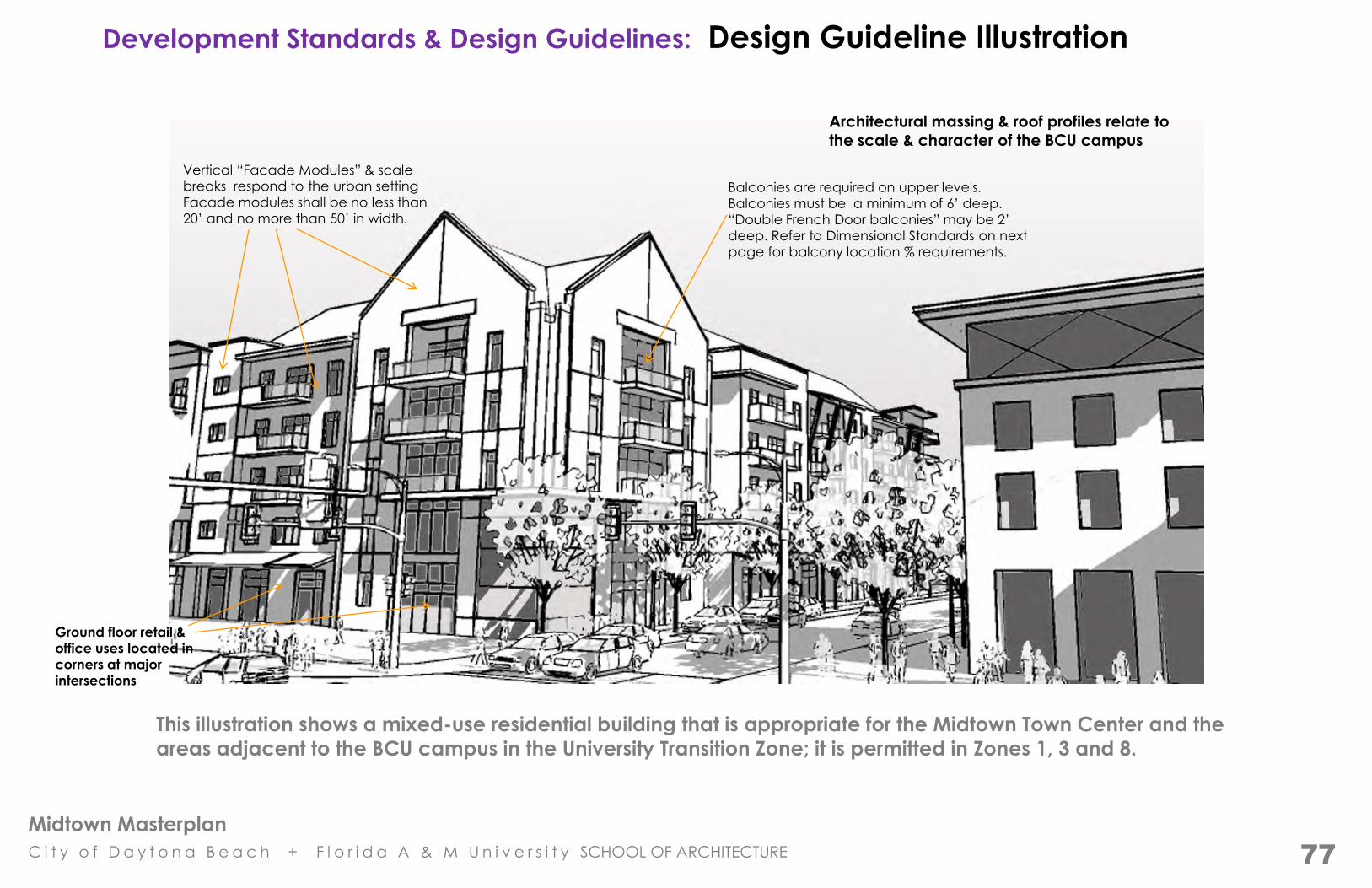
Midtown Masterplan
C i t y o f D a y t o n a B e a c h + F l o r i d a A & M U n i v e r s i t y SCHOOL OF ARCHITECTURE
Development Standards & Design Guidelines: Design Guideline Illustration
This illustration shows a mixed-use residential building that is appropriate for the Midtown Town Center and the
areas adjacent to the BCU campus in the University Transition Zone; it is permitted in Zones 1, 3 and 8.
Architectural massing & roof profiles relate to the scale & character of the BCU campus
Ground floor retail &
office uses located in
corners at major
intersections
Balconies are required on upper levels.
Balconies must be a minimum of 6’ deep.
“Double French Door balconies” may be 2’
deep. Refer to Dimensional Standards on next
page for balcony location % requirements.
Vertical “Facade Modules” & scale
breaks respond to the urban setting
Facade modules shall be no less than
20’ and no more than 50’ in width.
77
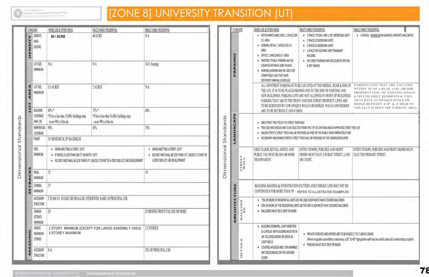
Midtown Masterplan
C i t y o f D a y t o n a B e a c h + F l o r i d a A & M U n i v e r s i t y SCHOOL OF ARCHITECTURE
78
5 STORIES (MAX.) & 2 STORIES (MIN.)
REFER TO ILLUSTRATED EXAMPLES
PARKING LOTS THAT ARE LOCATED WITHIN 30’ OF A REAR AND / OR SIDE PROPERTY LINE OF EXISTING SINGLE & MULTIFAMILY RESIDENTIAL USES MUST HAVE AN OPAQUE FENCE OR HEDGE BETWEEN 4’-8” & 6’ HIGH TO VISUALLY SCREEN THE PARKING AREA.
60 / ACRE
Development Standards
2 STORY MINIMUM (EXCEPT FOR LARGE ASSEMBLY USES)
5 STOREY MAXIMUM
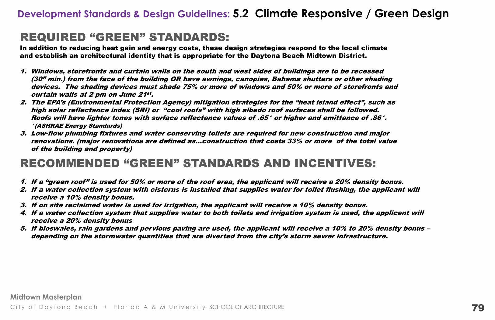
Midtown Masterplan
C i t y o f D a y t o n a B e a c h + F l o r i d a A & M U n i v e r s i t y SCHOOL OF ARCHITECTURE
Development Standards & Design Guidelines: 5.2 Climate Responsive / Green Design
REQUIRED “GREEN” STANDARDS:
In addition to reducing heat gain and energy costs, these design strategies respond to the local climate
and establish an architectural identity that is appropriate for the Daytona Beach Midtown District.
1. Windows, storefronts and curtain walls on the south and west sides of buildings are to be recessed
(30” min.) from the face of the building OR have awnings, canopies, Bahama shutters or other shading
devices. The shading devices must shade 75% or more of windows and 50% or more of storefronts and
curtain walls at 2 pm on June 21st
.
2. The EPA’s (Environmental Protection Agency) mitigation strategies for the “heat island effect”, such as
high solar reflectance index (SRI) or “cool roofs” with high albedo roof surfaces shall be followed.
Roofs will have lighter tones with surface reflectance values of .65* or higher and emittance of .86*.
*(ASHRAE Energy Standards)
3. Low-flow plumbing fixtures and water conserving toilets are required for new construction and major
renovations. (major renovations are defined as…construction that costs 33% or more of the total value
of the building and property)
RECOMMENDED “GREEN” STANDARDS AND INCENTIVES:
1. If a “green roof” is used for 50% or more of the roof area, the applicant will receive a 20% density bonus.
2. If a water collection system with cisterns is installed that supplies water for toilet flushing, the applicant will
receive a 10% density bonus.
3. If on site reclaimed water is used for irrigation, the applicant will receive a 10% density bonus.
4. If a water collection system that supplies water to both toilets and irrigation system is used, the applicant will
receive a 20% density bonus
5. If bioswales, rain gardens and pervious paving are used, the applicant will receive a 10% to 20% density bonus –
depending on the stormwater quantities that are diverted from the city’s storm sewer infrastructure.
79
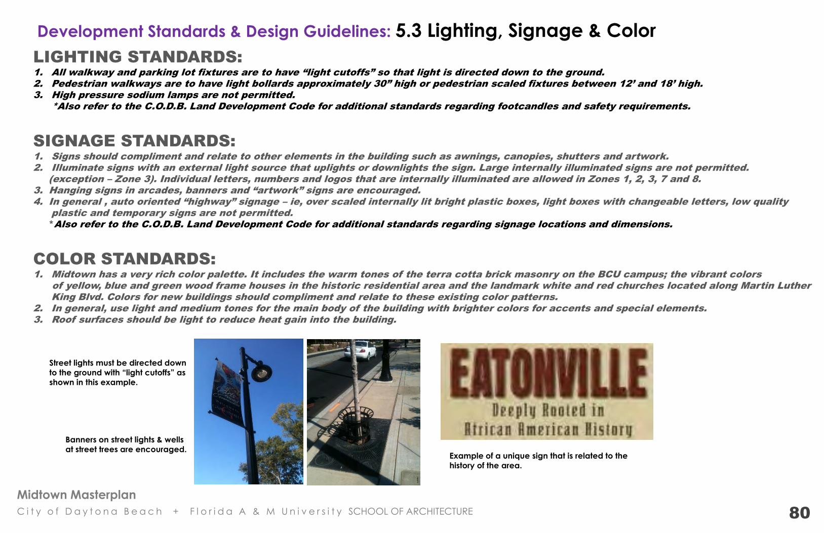
Midtown Masterplan
C i t y o f D a y t o n a B e a c h + F l o r i d a A & M U n i v e r s i t y SCHOOL OF ARCHITECTURE
Development Standards & Design Guidelines: 5.3 Lighting, Signage & Color LIGHTING STANDARDS:
1. All walkway and parking lot fixtures are to have “light cutoffs” so that light is directed down to the ground.
2. Pedestrian walkways are to have light bollards approximately 30” high or pedestrian scaled fixtures between 12’ and 18’ high.
3. High pressure sodium lamps are not permitted.
*Also refer to the C.O.D.B. Land Development Code for additional standards regarding footcandles and safety requirements.
SIGNAGE STANDARDS:
1. Signs should compliment and relate to other elements in the building such as awnings, canopies, shutters and artwork.
2. Illuminate signs with an external light source that uplights or downlights the sign. Large internally illuminated signs are not permitted.
(exception – Zone 3). Individual letters, numbers and logos that are internally illuminated are allowed in Zones 1, 2, 3, 7 and 8.
3. Hanging signs in arcades, banners and “artwork” signs are encouraged.
4. In general , auto oriented “highway” signage – ie, over scaled internally lit bright plastic boxes, light boxes with changeable letters, low quality
plastic and temporary signs are not permitted.
*Also refer to the C.O.D.B. Land Development Code for additional standards regarding signage locations and dimensions.
COLOR STANDARDS:
1. Midtown has a very rich color palette. It includes the warm tones of the terra cotta brick masonry on the BCU campus; the vibrant colors
of yellow, blue and green wood frame houses in the historic residential area and the landmark white and red churches located along Martin Luther
King Blvd. Colors for new buildings should compliment and relate to these existing color patterns.
2. In general, use light and medium tones for the main body of the building with brighter colors for accents and special elements.
3. Roof surfaces should be light to reduce heat gain into the building.
Banners on street lights & wells
at street trees are encouraged. Example of a unique sign that is related to the
history of the area.
80
Street lights must be directed down
to the ground with “light cutoffs” as
shown in this example.
Midtown Masterplan
C i t y o f D a y t o n a B e a c h + F l o r i d a A & M U n i v e r s i t y SCHOOL OF ARCHITECTURE
1. Adopt the plan
2. It is critical that information is shared and various public departments, private initiatives, existing businesses and residents work together to
achieve the plan. To that end, a Project Manager / Coordinator position must be established. This person will coordinate all Midtown related
redevelopment activities & initiatives and should have experience in planning/design and/or real estate development. The Project Manager
would coordinate the following:
a) All public works projects / improvements; b) public funding initiatives; c) medium and large scale private development projects; d) packaging and
marketing of targeted redevelopment sites; e) coordination with existing businesses and property owners; f) coordination with Bethune Cookman University expansion; g) code enforcement and condemnation, and h) any other major development activities associated with the Midtown CRA. The Project Manager would work under the direction of the City of Daytona Beach Planning / Redevelopment Department and periodically update the Midtown Board.
3. Create a funding and grant initiative data base.
4. Develop a series of projects that will be funded by Community Block Grants from the U.S Department of Housing and Urban Development.
5. Create a Black Heritage Walk and Florida African American Museum & Research Center funding initiative.
6. Establish partnerships with national, regional and local community banks, lenders, investors and foundations.
7. Develop business start up, entrepreneur and expansion incentives.
8. Establish and market an improved clear, logical and efficient permitting and entitlement review / approval process for renovations, expansion
and new development. Development approvals would be based on the proposed Land Development Regulations and Development
Standards in the adopted Midtown Master Plan.
9. Create a Midtown real estate website for public and private land that includes cost, characteristics and all permitting / entitlement limits and
requirements. Each parcel would have links with the Master Plan with illustrations of possible development scenarios.
10. Initiate public and private property acquisitions, exchanges and consolidations to achieve the adopted Master Plan.
11. Encourage and promote “grassroots” community improvement organizations and initiatives. An example is the Community Garden
Stewardship Program. Through healthy food / healthy neighborhood programs – various churches, community groups, nonprofit organizations,
BCU student groups and others would participate in the Midtown Community Garden. The garden would be located on public property and
each group would have a raised garden plot that they would plant, maintain and harvest. A public market would be established during
certain times of the year to sell produce and flowers. There would also be “friendly competitions” between the various community groups.
Food that is not sold would be donated to neighborhood residents and families.
12. Establish a demolition and salvage program for abandoned and condemned buildings.
13. Establish a green renovation program which includes an energy audit and offer low-interest loans for renovations and building improvements
that reduce energy and water consumption.
14. Create an incentive program for renovating and modifying through adaptive reuse the existing historic buildings and the contributing
structures in Zone 6 – Residential Preservation / Historic Infill District.
Redevelopment Proposals: 4.11 Implementation Strategies - Immediate Actions: 2012 to 2015
44
Midtown Masterplan
C i t y o f D a y t o n a B e a c h + F l o r i d a A & M U n i v e r s i t y SCHOOL OF ARCHITECTURE
Redevelopment Proposals: 4.11.1 Implementation Strategies
Mid-Range Actions: 2016 to 2025 1. Finalize the land acquisition for the new Town Center Plaza / Square and Dickerson Park Expansion.
2. On primary streets – place all overhead electrical below ground; complete drainage, sidewalk, street light & on street parking improvements.
3. Significant private sector development is started. The plan is “fleshed out” through incremental small and medium scale development.
4. The Lincoln Greenway and Thurman Gardens are completed.
Long Range Actions: 2026 to 2035 1. The Town Center and all 5 Neighborhood Centers are completed.
2. Significant private sector development is completed. The plan is “fleshed out” through incremental small, medium
and large scale development.
Regarding commercial real estate development in underserved communities…. “Ultimately, it is retailers in partnership with developers that drive development. Therefore, it is important for the public officials and community
leaders to understand the “cycle” of economic development in general and the retail development process specifically in order to have
realistic expectations for development and to work productively with developers to meet the development objectives of the community.
For example, even if all the identified challenges and issues are addressed, in most cases there will still be a necessary progression to the retail
development of underserved markets - often beginning with fast food restaurants and drug stores, progressing to grocery stores and discount
apparel and shoes and eventually ending with specialty retailers and higher priced concepts.”
Credit: Development in Underserved Retail Markets A summary of a discussion of the challenges and recommendations for improving the process of retail development in underserved, urban markets Co-written and Edited by: Cynthia Stewart, Director, Local Government Relations & Alexis Morris, Manager, Community Investment International Council of Shopping Centers Business for Social Responsibility
“Economic Development is encouraged by certainty and clear development standards that
establish a consistent level of quality. A property owner, developer or business does not want to
invest in an area where they have no idea of what could happen on either side of their project.”
Craig Huffman AIA, Architect & Professor
FL A & M University
45
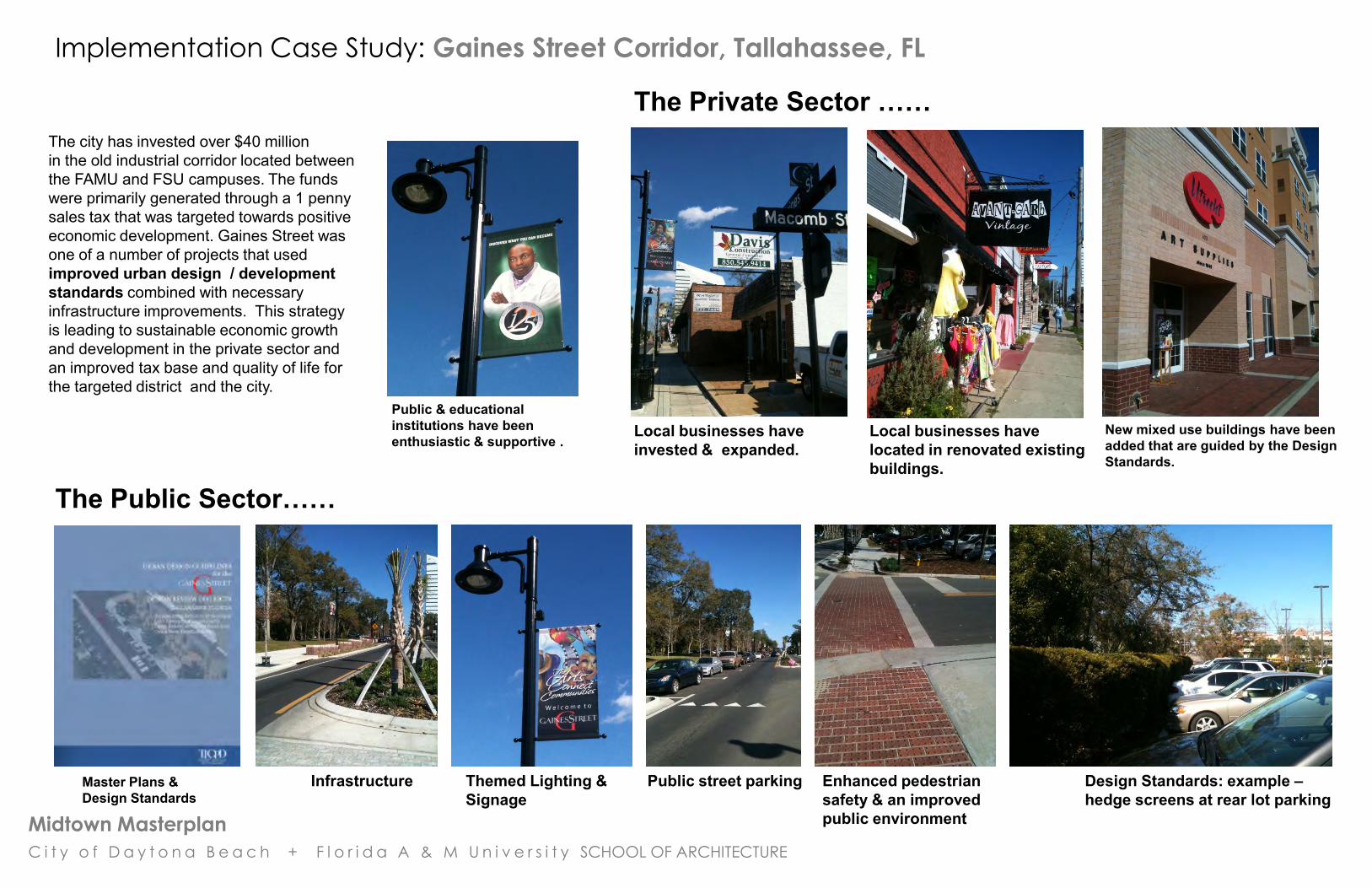
Midtown Masterplan
C i t y o f D a y t o n a B e a c h + F l o r i d a A & M U n i v e r s i t y SCHOOL OF ARCHITECTURE
Implementation Case Study: Gaines Street Corridor, Tallahassee, FL
Local businesses have invested & expanded.
Local businesses have located in renovated existing buildings.
New mixed use buildings have been added that are guided by the Design Standards.
Public & educational institutions have been enthusiastic & supportive .
The Private Sector ……
The Public Sector…… ……
Infrastructure Design Standards: example – hedge screens at rear lot parking
Themed Lighting & Signage
Public street parking
Enhanced pedestrian safety & an improved public environment
The city has invested over $40 million in the old industrial corridor located between the FAMU and FSU campuses. The funds were primarily generated through a 1 penny sales tax that was targeted towards positive economic development. Gaines Street was one of a number of projects that used improved urban design / development standards combined with necessary infrastructure improvements. This strategy is leading to sustainable economic growth and development in the private sector and an improved tax base and quality of life for the targeted district and the city.
Master Plans & Design Standards