A487 CAERNARFON AND BONTNEWYDD BYPASS Appendix F.1 ...
86
A487 CAERNARFON AND BONTNEWYDD BYPASS Appendix F.1 – Preliminary Sources Study
Transcript of A487 CAERNARFON AND BONTNEWYDD BYPASS Appendix F.1 ...

A487 CAERNARFON AND BONTNEWYDD BYPASS
Appendix F.1 – Preliminary Sources Study

A487 CAERNARFON AND BONTNEWYDD BYPASS

A487 CAERNARFON TO
BONTNEWYDD BYPASS
PRELIMINARY SOURCES STUDY
REPORT
Welsh Government
3513874-PB-XX-XX-GE-00003
Final

A487 Caernarfon to Bontnewydd Bypass Preliminary Sources Study Report
3513874-PB-XX-XX-RP-GE-00003 Prepared by Balfour Beatty/Jones Bros JV February 2015 for Welsh Government - 2 -
A487 Caernarfon to Bontnewydd Bypass
Preliminary Sources Study Report
3513874-PB-XX-XX-GE-00003
Prepared for Welsh Government Welsh Government
Sarn Mynach Llandudno Junction
Conwy LL31 9RZ
Prepared by Jones Bros. Balfour Beatty JV
Ty Glyn, Canol Y Dre Ruthin LL15 1QW
Telephone 01824 703661

A487 Caernarfon to Bontnewydd Bypass Preliminary Sources Study Report
3513874-PB-XX-XX-RP-GE-00003 Prepared by Balfour Beatty/Jones Bros JV February 2015 for Welsh Government - 3 -
Report Title : A487 Caernarfon to Bontnewydd Bypass Preliminary Sources Study Report Doc Number : 3513874-PB-XX-XX-GE-00003 Report Status : Final Job No : 3513874A-HHC Date : February 2015
DOCUMENT HISTORY AND STATUS AUTHORISATION SHEET
Document control
Prepared by Tom Parkinson Checked by (technical)
Guy Swains
Approved by Russell Bennett Checked by (quality assurance)
Kevin Power
Revision details
Version Date Pages
affected Comments
20/02/2015 P01 Preliminary Issue
06/08/2015 P02 Following WG comments

A487 Caernarfon to Bontnewydd Bypass Preliminary Sources Study Report
3513874-PB-XX-XX-RP-GE-00003 Prepared by Balfour Beatty/Jones Bros JV February 2015 for Welsh Government - 4 -
CONTENTS Page
INTRODUCTION 5
1 INTRODUCTION 6
SOURCES OF INFORMATION & DESK STUDY 7
2 SOURCES OF INFORMATION & DESK STUDY 8
FIELD STUDIES 9
3 FIELD STUDIES 10
SITE DESCRIPTION 11
4 SITE DESCRIPTION 12
4.1 General 12
4.2 Solid Geology 13
4.3 Superficial Geology 14
4.4 Groundwater Vulnerability Map 15
4.5 Southern section (Ch0000-Ch3500) 15
4.6 Central section (Ch3500 – Ch6500) 16
4.7 Northern section (Ch6500-Ch9700) 17
4.8 Historical Development 19
4.9 Potential Contamination Sources 22
4.10 Mining and Quarrying 22
4.11 Additional Information 25
GROUND CONDITIONS 27
5 GROUND CONDITIONS 28
5.1 Geology 28
PRELIMINARY ENGINEERING ASSESSMENT 31
6 PRELIMINARY ENGINEERING ASSESSMENT 32
6.1 Southern section (Ch0-Ch3500) 32
6.2 Central section (Ch3500-Ch6500) 33
6.3 Northern section (Ch6500-Ch9700) 34
Comparison of project options and risks 36
7 Comparison of project options and risks 37
REFERENCES
8 REFERENCES 41

A487 Caernarfon to Bontnewydd Bypass Preliminary Sources Study Report
3513874-PB-XX-XX-RP-GE-00003 Prepared by Balfour Beatty/Jones Bros JV February 2015 for Welsh Government
- 5 -
SECTION 1
INTRODUCTION

A487 Caernarfon to Bontnewydd Bypass Preliminary Sources Study Report
3513874-PB-XX-XX-RP-GE-00003 Prepared by Balfour Beatty/Jones Bros JV February 2015 for Welsh Government
- 6 -
1 INTRODUCTION
1.1.1 This Preliminary Sources Study Report (PSSR) has been undertaken in
accordance with HD22/08 of the Design Manual for Roads and Bridges.
1.1.2 The study area is situated in north west Wales in the county of Gwynedd, to the south east of Caernarfon (Grid Ref: 48040 62700) as shown on Figure 1. Caernarfon is a coastal town and is well known for its stone castle dating from the fourteenth century. There are several smaller villages surrounding Caernarfon with the majority of the land being used for agriculture and to a lesser extent light industry. The landscape of the area is mainly open fields with fences and hedges as boundaries. The landscape around Caernarfon can be described as gently rolling hills, generally sloping towards the coast. There are two major rivers in the area of interest, the Afon Gwyrfai and the Afon Seiont, flowing westwards down slope from the high ground of Snowdonia National Park centred to the east. There are small pockets of woodland confined to the valleys of these rivers.
1.1.3 The study area, as set out in the scope of works is defined as the 100m corridor running adjacent to the centreline extending from Llanwnda to the south west of Caernarfon through to Plas Menai to the north east of Caernarfon for a length of approximately 10km.
1.1.4 The corridor covers the lower slopes of the mountain ranges of Snowdonia, gently sloping from east to west towards the coast. The corridor stretches from approximately 500m south of Llanwnda to the Felinheli/Plas Menai roundabout, bypassing the town of Caernarfon as well as the villages of Llanwnda and Bontnewydd.
1.1.5 For ease of understanding the alignment is split into 3 sections.
Southern section (Ch0-Ch3500) running from 500m south of Llanwnda to 500m north of Bontnewydd
Central section (Ch3500-Ch6500) running from 500m north of Bontnewydd to 1km north of Caeathro
Northern section (Ch6500-Ch9700) running from 1km north of Caeathro to the Felinheli/Plas Menai roundabout.
No ground investigation data has been used in the preparation of this report.

A487 Caernarfon to Bontnewydd Bypass Preliminary Sources Study Report
3513874-PB-XX-XX-RP-GE-00003 Prepared by Balfour Beatty/Jones Bros JV February 2015 for Welsh Government
- 7 -
SECTION 2
SOURCES OF INFORMATION & DESK STUDY

A487 Caernarfon to Bontnewydd Bypass Preliminary Sources Study Report
3513874-PB-XX-XX-RP-GE-00003 Prepared by Balfour Beatty/Jones Bros JV February 2015 for Welsh Government
- 8 -
2 SOURCES OF INFORMATION & DESK STUDY
2.1.1 Various sources of information were reviewed for this study, these are indicated below.
2.1.2 The initial data source for this study is the available published geology. There is map coverage of the study area at One-Inch scale, published by the British Geological Survey (BGS), Geological Old Sheet 78, Caernarfon (Ref 1). This map was published in 1852. No revisions have been published to date. No borehole records within the study area of study have been published by the BGS.
2.1.3 Unpublished geological maps were made available by the BGS and have been reviewed in the production of this document.
2.1.4 Historical Ordnance Survey maps for the study area have been obtained from Landmark Information Group (Ref. 2) in the form of an Envirocheck Report. Plans dating from 1888 to 2009 illustrate the historical development in the study area. This is discussed in Section 4.8. Additional data provided with the historical OS maps include details of Regionally Important Geological and Geomorphological Sites (RIGGS), and other protected sites, such as Sites of Special Scientific Interest (SSSI). The historical maps will also provide information on the presence of past landslips within the area. No historic landslips are identified on the most recent publication of historic maps.
2.1.5 Further information provided with the Envirocheck Report includes data on pollution incidents, waste management locations, hydrology and mineral exploitation.
The Envirocheck Report has been presented in digital format in Appendix A, B, &C.

A487 Caernarfon to Bontnewydd Bypass Preliminary Sources Study Report
3513874-PB-XX-XX-RP-GE-00003 Prepared by Balfour Beatty/Jones Bros JV February 2015 for Welsh Government
- 9 -
SECTION 3
FIELD STUDIES

A487 Caernarfon to Bontnewydd Bypass Preliminary Sources Study Report
3513874-PB-XX-XX-RP-GE-00003 Prepared by Balfour Beatty/Jones Bros JV February 2015 for Welsh Government
- 10 -
3 FIELD STUDIES
Field studies for the PSS were confined to a walkover study of selected areas that were accessible by public rights of way. A walkover survey was originially undertaken by Parsons Brinckerhoff Ltd in March 2009 with a more recent walkover during December 2014.The walkovers were limited to public rights of way due to access rights under the Highways Act not being taken. No intrusive investigations were carried out as part of this study. The findings of the walkover surveys are detailed in this report.
The information gleaned from site walkovers in 2009 and 2014 has been included in the writing of the report.
Furthermore, Google Earth Pro has been used to improve knowledge on specific areas of interest along the length of the proposed alignment. Examples include the Seiont quarry.

A487 Caernarfon to Bontnewydd Bypass Preliminary Sources Study Report
3513874-PB-XX-XX-RP-GE-00003 Prepared by Balfour Beatty/Jones Bros JV February 2015 for Welsh Government
- 11 -
SECTION 4
SITE DESCRIPTION

A487 Caernarfon to Bontnewydd Bypass Preliminary Sources Study Report
3513874-PB-XX-XX-RP-GE-00003 Prepared by Balfour Beatty/Jones Bros JV February 2015 for Welsh Government
- 12 -
4 SITE DESCRIPTION
4.1 General
4.1.1 Caernarfon is located on the coast of north west Wales on the banks of the Menai Strait, which separates the island of Anglesey and mainland Wales. The approximate National Grid Reference of the southern extent is SH 47262 57725 and the northern extent SH 50518 65756. The topography of the surrounding area comprises gently sloping ground towards the coast influenced by the higher grounds of Snowdonia National Park located approximately 5km to the south east.
Photo 1: Looking south east towards Snowdonia National Park from the B4366
4.1.2 The rugged landscape of the Snowdonia mountain range reaches a maximum height ranging from 605mAOD at Foel Goch up to 1085mAOD at Yr Wyddfa (Snowdon). The ground elevation rapidly decreases to a maximum of 70mAOD along the proposed alignment.
4.1.3 The lower ground is dissected by two major rivers originating from large lakes located in the valleys of Snowdonia. The Afon Gwyrfai running from Llyn Cwellyn, flows through the town of Bontnewydd into Foryd Bay. The Afon Seiont of Llyn Padarn joins the Menai Strait at Caernarfon. There are several smaller rivers and tributaries that follow the same dendritic drainage pattern as these rivers including the Afon Rhyd running through Llanwnda, and the Afon Beuno to the north east of Bontnewydd,
4.1.4 To the north west of the study area lies the coastal town of Caernarfon, however the study area is characterised by agricultural land and isolated pockets of woodland. The height of the study area ranges from a maximum of 70mAOD to the east of Bontnewydd to approximately 20mAOD at the Gwyrfai river (Ch2000). The main roads in the area are the A487, A4085, A499 and A4086 Trunk Roads providing the main routes of access and egress to Caernarfon. The A487 runs

A487 Caernarfon to Bontnewydd Bypass Preliminary Sources Study Report
3513874-PB-XX-XX-RP-GE-00003 Prepared by Balfour Beatty/Jones Bros JV February 2015 for Welsh Government
- 13 -
North to South from Llanwnda through Caernarfon and then along the coast to Bangor. The A4085 and A4086 Trunk Roads run from Caernarfon to the South-East and East respectively. The A499 runs North-East and joins the A487 South of Llanwnda and forms the roundabout at the start of the proposed bypass route. The Welsh Highland Railway runs from Beddgelert to Caernarfon, alongside the A487 Trunk Road with exception between Bontnewydd and Caernarfon where it diverts around 700m westwards from roadside through the village of Bronydd.
4.2 Solid Geology
4.2.1 The solid geology of the area is shown in Figure 3. All solid geology relates to the wider area due to the lack of published geological data available.
4.2.2 The solid geology of the area comprises rocks from the Pre-Cambrian through to the Carboniferous. Although no Devonian geology is identified. The oldest (Pre-Cambrian) rocks in the area are exposed in a ridge which trends northeast-southwest from Bangor to Caernarfon. The rocks constitute the Arvonian Volcanic Series, consisting mainly of rhyolitic volcanic rocks and acid tuffs; particularly ignimbrites. There are also lesser volumes of ash-fall tuffs, agglomerates, intrusive rhyolites and granites. This series forms the ridge ‘Twt Hill’ to the north east of Caernarfon (Ref. 3).
4.2.3 The base of the Cambrian rocks indicated by the BGS geological map is the Conglomerate and Sandstone division (Fig 3). This contains the Tryfan Grit Group, Cilgwyn Conglomerate and the Glog Grit Group. The Tryfan Grit Group is around 300m thick and consists of a lower division of coarse grained sandstones showing large-scale cross bedding, and an upper division of finely parallel-laminated white weathering siltstones. The siltstones are dark grey to green on freshly fractured surfaces, and may represent re-worked vitric tuffs. The succeeding coarse-grained Cilgwyn Conglomerate is up to 400m thick, and contains well rounded pebbles of Arvonian Volcanics up to 0.15mcm in diameter. The Glog Grit comprises a group of coarse and fine grained sandstones and quartzites with subordinate thin slaty beds. The beds are commonly cross bedded (Ref. 3)
4.2.4 According to the BGS map there is a break in succession between the Cambrian and Silurian rocks. It is suggested that Ordovician rocks outcrop to the south of Caernarfon, along the section of the Afon Seiont that joins with the Sea (Ref. 3). This section is faulted at the base and is incomplete beginning with about 130m of Lower Arenig strata comprising interbedded grey-black shales, siltstones and thin, often calcareous fine-grained sandstones. Overlying are 200m of Upper Arenig rocks, which are the same but generally finer grained.
4.2.5 The geological information provided by Landmark (Ref. 2) indicates that the area is underlain by Lower Ordovician rocks comprising the Arenig, Llanvirn and Llandeilo succession. No geological descriptions have been provided by Landmark.
4.2.6 The Silurian rocks in the wider area are the Benarth Flags and Grits comprising turbidite siltstones, sandstones and intercalated shales. The sandstones thicken and coarsen upward and are often graded.
4.2.7 Carboniferous rocks outcrop along the mainland shore of the Menai Straits between Bangor and Caernarfon. They are bounded on the mainland side by the Dinorwic Fault above the Cambrian rocks. The formations present in the study area are the Lower Carboniferous Limestone and the Upper Carboniferous Red Measures. The Carboniferous Limestone Formation comprise of fine-grained

A487 Caernarfon to Bontnewydd Bypass Preliminary Sources Study Report
3513874-PB-XX-XX-RP-GE-00003 Prepared by Balfour Beatty/Jones Bros JV February 2015 for Welsh Government
- 14 -
limestones containing thin lenses of sandstones. Calcareous shale beds are found within the middle of the formation. Red Measures outcrop near to Caernarfon consisting of plane-bedded red marls with occasional grey-green pebbly beds. The succession includes conglomerates consisting of pebbles held in a red sandy matrix.
4.2.8 There are two major faults trending northeast to southwest in the study area. The Dinorwic fault to the north separates the Arvonian Volcanic Series and the Red Measures passing through the town of Caernarfon. The fault in the south separates the Cambrian and Ordovician/Silurian rocks passing through Llanwnda. These faults terminate on a smaller north-south trending fault.
4.3 Superficial Geology
4.3.1 Made Ground is not shown on the BGS map and no information has been obtained to provide details on this. It is possible Made Ground is present in the area, however location, extent and thickness is unknown. Historical land use is discussed in section 4.8.
4.3.2 There is limited information available on the drift deposits of the study area. There is no published BGS map of the superficial geology for the area.
4.3.3 Unpublished geological maps have been used to improve the understanding of the superficial geology in the study area. The area is shown to be dominated by glacial deposits as indicated by (Ref. 4) in the form of Glaciofluvial sheet deposits (sands and gravels), Hummocky Glacial deposits and Glacial Till.
4.3.4 North Wales has been affected by past glacial processes and it is likely that drift deposits are present in the area (Ref. 4). Existing information on the area of Caernarfonshire suggest the entire area is covered in Glacial Till (Ref. 4 & Ref. 5). This is likely to be sandy gravelly clay although there are variations in these types of soils.
4.3.5 Existing Information from the Pen-y-Bryn brickworks near Caernarfon indicates there is a cutting displaying up to 15m of glacial deposits (Ref 4). The basal layer being a soliflucted blue-grey glacial till containing gravels mainly of Ordovician shale origin. Overlying this is a layer of fluvio-glacial sands and gravels around 10m thick. This layer contains boulders from 4.5m up to 6m in length originating from the mountains of Snowdonia.
4.3.6 Sources of information indicate that the lowlands to the northeast of Caernarfon adjacent the coast are covered in thick deposits of meltwater sands and gravels deriving from Snowdonia (Ref. 4) comprising of Cambrian slate, Ordovician shale and igneous rocks.
4.3.7 It is likely there are deposits of alluvium in the proximity of the rivers that are not shown on the BGS maps. These deposits are likely to vary in soil type consisting of gravels, sands, silts, and clays..
4.3.8 Alluvial and Terrace deposits are also identified as being present in the form of gravels, sands, silt and clay. Areas of peat are also known to be present, most notably at the northernmost extents (ch8300-ch8800) of the scheme.
4.3.9 Zones of Peat deposits have been identified through walkover studies undertaken in 2009 and 2014, the depth and extents of these deposits are unknown. These are likely to be post glacial deposits of the Holocene epoch (See figure 4).

A487 Caernarfon to Bontnewydd Bypass Preliminary Sources Study Report
3513874-PB-XX-XX-RP-GE-00003 Prepared by Balfour Beatty/Jones Bros JV February 2015 for Welsh Government
- 15 -
A detailed ground investigation is required to provide information on the drift deposits throughout the study area (See figure 4).
4.4 Groundwater Vulnerability Map
4.4.1 The Groundwater Vulnerability Map of the area indicates that the study area is underlain by northeast-southwest trending, meandering strips, of designated high to low Minor-Aquifers (variably permeable). The aquifers range from 100m to 1km in width with general alignment being parallel to the coastline. It is likely the aquifers outline the extents of the Quaternary drift deposits. These types of deposits are probably high in gravel and sand content thus having have high permeability. The orientation and alignment of these deposits are likely to be the remnants of Quaternary braided river networks. The glacier advance and retreat movements in this area are generally in a northeast to southwest direction (Ref. 4). During the retreat phase the meltwater from the glacier, generally flows in the same direction of movement. The aquifers outline the coarser material deposited by the higher energy paleo-rivers. Although not producing large quantities of water for abstraction, these aquifers do supply small businesses and small farms in the area and supply the base flow to rivers. Where sections do not run over these minor aquifers, the underlying geology is designated as a ‘Non Aquifer of negligibly permeability’.
4.4.2 Hydrogeology
A comprehensive hydrological report has been prepared. Please see document number 3513874-PB-XX-XX-RP-GE-00004 – Hydrological Desk Study.
4.5 Southern section (Ch0000-Ch3500)
Alignment
4.5.1 The proposed alignment runs offline to the west of the current A487 Trunk Road, bypassing the village of Llanwnda at Ch1000. The proposed alignment runs due north to Ch2000 where it curves to run north east, bypassing the village of Bontnewydd to the south. The alignment continues to run north east to a roundabout at Ch3500 where it intersects the present A487 Trunk Road with access to Caernarfon to the north and Bontnewydd to the south.
4.5.2 Topography
The topography of the wider area is characterised by gently rolling slopes running down from snowdonia towards the Menai Straights. The proposed alignment intersects a number of small valleys associated with the rivers and tributaries discussed previously. The village of Bontnewydd is located adjacent the Afon Gwyrfai at an elevation of 30mAOD with gentle slopes to the north and south. Llanwnda is situated at a slightly higher elevation of 60mAOD. The landscape reaches heights of 70mAOD in the east falling to 30mAOD in the west. There are several farms and small holdings scattered throughout this section. The alignment runs north north east running to the east of the villages of Llanwnda and Bontnewydd. The land use is predominantly agricultural.

A487 Caernarfon to Bontnewydd Bypass Preliminary Sources Study Report
3513874-PB-XX-XX-RP-GE-00003 Prepared by Balfour Beatty/Jones Bros JV February 2015 for Welsh Government
- 16 -
Photo 2: Looking north west from the entrance to Plas Dinas Hotel. The proposed alignment will run left to right as viewed in this photo.
Hydrology
4.5.3 The major surface water feature identified in the corridor is the Afon Gwyrfai
running through the northern part of the corridor near the village of Bontnewydd. There are several smaller streams around Llanwnda that flow down to Foryd Bay to the north west. The EA flood mapping indicates that Llanwnda is at risk of flooding from these smaller rivers. The map also indicates that southern parts of Bontnewydd are at risk of extreme flooding from the Afon Gwyrfai. Flood defences have been constructed along the south-western outskirts of the village. Flood mapping is shown in Appendix A
4.6 Central section (Ch3500 – Ch6500)
Alignment
4.6.1 The proposed alignment runs north east from Ch3500 running almost parallel to the ‘Bontnewydd - Caeathro’ road to the south. At Ch4500 the alignment curves to run north skirting around the Seiont quarry which is located approximately 100m to the north west of the alignment. The alignment then curves to an easterly orientation bypassing the village of Caeathro to the south east at Ch5500. Between Ch5700 and 6500 the alignment runs adjacent to the Cibyn industrial estate. A roundabout at Ch6500 provides access to eastern Caernarfon and the A4086 Llanberis road.
Topography
4.6.2 The central section is located on the outskirts of Caernarfon from north of Bontnewydd (ch3500) (SH48330 60560) to the east of the Cibyn industrial estate (Ch6500) (SH50170 62950). The topography is characterised by gently rolling hills ranging in height from 40mAOD to 70mAOD. The majority of the section

A487 Caernarfon to Bontnewydd Bypass Preliminary Sources Study Report
3513874-PB-XX-XX-RP-GE-00003 Prepared by Balfour Beatty/Jones Bros JV February 2015 for Welsh Government
- 17 -
comprises farmland along with the Cibyn Industrial Estates and Caernafron Seiont Quarry located to the south west of Caernarfon. The proposed alignment intersects the the A4085 Waunfawr road, A4086 Llanberis road as well as a number of minor roads. There are several small pockets of woodland throughout the section but these are mainly confined to the banks of the Afon Seiont.
Hydrology 4.6.3 The major surface water feature identified in this section is the Afon Seiont. The
Afon Seiont runs east to west collecting surface water from the catchment areas of Snowdonia. The Afon Cadnant is a smaller river flowing northwest to southeast through the northern part of the corridor. There are several smaller streams in the area joining with the above larger rivers. The EA flood mapping indicates that Glangwna Holiday and Caravan Park at risk of flooding from the adjacent Afon Seiont. The Seiont Caernarfon Quarry is also at risk of extreme flooding. This is likely caused by flood events connecting with the Afon Seiont or from prolonged periods of heavy rainfall collecting in the opencast clay pit. Flood mapping is shown in Appendix A
4.7 Northern section (Ch6500-Ch9700)
Alignment
4.7.1 The proposed alignment runs north east through agricultural land to Ch8000 where it curves to run due north. At Ch8400 the proposed alignment intersects the B4366 and continues to run north to its most northerly extent at Ch9700.
Topography 4.7.2 The northern corridor extends from the east of the Cibyn industrial estate
(Ch6500) SH 50087 62893 to the Plas Menai roundabout at the end of the scheme (Ch9700) SH 50518 65756. The topography between Cibyn industrial estate and Plas Menai is gently rolling, generally following the river pattern of the Afon Seiont and Afon Cadnant. The landscape slopes to the north west, with slight changes in elevation between 60mAOD at its maximum elevation to a minimum of 20mAOD at the northernmost extent of the scheme at the Plas Menai roundabout. The majority of the corridor covers farmland with occasional woodland with the exception of where the proposed alignment intersects the B4366 which runs adjacent to the proposed alignment.

A487 Caernarfon to Bontnewydd Bypass Preliminary Sources Study Report
3513874-PB-XX-XX-RP-GE-00003 Prepared by Balfour Beatty/Jones Bros JV February 2015 for Welsh Government
- 18 -
Photo 3: Looking south west from roundabout near Plas Menai at the northernmost extents of the alignment. Section of cutting runs to south east from this locality. Hydrology
4.7.3 The major surface water feature identified in the corridor is the Afon Seiont. The Afon Seiont runs northwest to southeast collecting surface water from the catchment areas of the Snowdonia National Park. The Afon Cadnant is a smaller river flowing parallel to the Afon Seiont through the section. There are many smaller streams in the area joining with these rivers. Envirocheck reports (Appendix A) indicate that the north west of Pont-rug is at risk of flooding from the Afon Seiont however this is located to the east of the proposed alignment and considered too far away from the proposed alignment to pose any flood risk to the scheme. Flood mapping is shown in appendix A.

A487 Caernarfon to Bontnewydd Bypass Preliminary Sources Study Report
3513874-PB-XX-XX-RP-GE-00003 Prepared by Balfour Beatty/Jones Bros JV
for Welsh Government February2015
- 19 -
4.8 Historical Development
Historical maps provided by the LandMark Information Group were consulted to undertake a study of the three sections. The maps were analysed for any major changes to the sections and the surrounding area were noted. The maps analysed were from 1888-2009. These are presented in appendix A.
Area
Date Southern section (Ch0000-Ch3500) Central section (Ch3500-Ch6500) Northern section (Ch6500-Ch9700)
1888 The majority of the corridor is covered by farmland with small farms and holdings scattered throughout. The Caernarfonshire Branch railway runs south to north through Llanwnda and alongside Bontnewydd. The village of Bontnewydd is slightly larger in size than Llanwnda
The majority of the map is farmland with small farms and holdings scattered throughout. Seiont Brickworks, Mill and Tannery and Peblig Flour Mill are open in Peblig Estate (400m west of proposed alignment at Ch5500). Small village at Caeathro (500m east of proposed alignment at Ch5500). Significant forestry at Glan Gwna around a large holding
The majority of the map is farmland with small farms and holdings scattered throughout
1901 No change Seiont Brick Works and adjacent clay pit opened (100m west of proposed alignment at Ch4700).
No change
1919-1920 Small quarry near to Dinas Farm opened and closed (300m east of the proposed alignment at Ch1500).
Reservoir and water works constructed along with large Fish pond at Felin-bach (340m east of proposed alignment at Ch5500).
Quarry near Gareg-Goch Farm closed (1.3km north east of proposed alignment) Cerrig yr Afon Farm (formerly The Beehive) and adjacent reservoir constructed (1.3km north east of proposed alignment)
1938 No change Parkia Brick Works closed No change
1953 No change Seiont Brick Works and adjacent clay pit increased in size. (100m west of proposed alignment at Ch4700).
No change
1963-1965 No change Tannery in Peblig Industrial Estate demolished (400m west of proposed alignment at ch5500). Refuse tips in Peblig and Cibyn Industrial Estates opened
Remains of Roman Signal Station found (100m east of the proposed alignment at Ch7000).

A487 Caernarfon to Bontnewydd Bypass Preliminary Sources Study Report
3513874-PB-XX-XX-RP-GE-00003 Prepared by Balfour Beatty/Jones Bros JV
for Welsh Government February2015
- 20 -
Reservoir at Felin-Bach disused
1976-1981 Coal yard formed to the south of Llanwnda (Adjacent to the proposed alignment at Ch0). Caernarfonshire Branch and North Wales Narrow Gauge Railway dismantled (crosses proposed alignment at Ch2700). Minor residential development in Bontnewydd (500m south of proposed alignment at Ch3500) and Llanwnda (870m west of proposed alignment at Ch1000). Sewage Works near to the Afon Gwyrfai constructed (500m west of the proposed alignment at Ch1500)
New Brick Works buildings constructed, old buildings demolished, major increase in size of clay pit Glangwna holiday park opened (Adjacent to the site at Ch5500) Caernarfonshire to Llanberis railway line dismantled Cibyn Industrial Estate increased in size.(Adjacent to the proposed alignment from Ch5800-Ch6500). Refuse Tip in Peblig Industrial Estate adjacent closed Road from Bontnewydd to Caeathro constructed and parts of old road widened (Runs parallel to proposed alignment from Ch3500-Ch5500)
Water works constructed near to Caerleon Tibot Minor residential development of Port Dinorwic and Bethel Griffiths Crossing Industrial Estate opened Sewage Works opened near to Griffiths Crossing Industrial Estate (400m south west of the proposed alignment at Ch9700).
1991 No change Clay pit at Seiont Brick Works decrease in size Cibyn Industrial Estate increased in size Large mill in Peblig Industrial Estate opened Glangwna Caravan Park increased in size
Plas Menai National Water Centre Opened (350m north west of the proposed alignment at Ch9700).
2000 No change Refuse Tip adjacent Cibyn Industrial Estate A487 trunk road from Port Dinorwic to Plas

A487 Caernarfon to Bontnewydd Bypass Preliminary Sources Study Report
3513874-PB-XX-XX-RP-GE-00003 Prepared by Balfour Beatty/Jones Bros JV
for Welsh Government February2015
- 21 -
closed Menai constructed (Adjacent to the northern extent of the proposed alignment at Ch9700).
2006 Roundabout constructed to the south of Llanwnda Welsh Highland Railway constructed along the original route of the of the north Wales Narrow Gauge and Caernarfon Railways (crosses proposed alignment at Ch2700).
Cibyn Industrial Estate increased in size Abattoir in Cibyn Industrial Estate opened (adjacent to the proposed alignment from Ch5700-Ch6500).
No change
2009 Gypsy Wood Lake tourist attraction opened (300m south east of the proposed alignment at Ch3900).
No change No change
2009-2015 No change No change No change

A487 Caernarfon to Bontnewydd Bypass Preliminary Sources Study Report
3513874-PB-XX-XX-RP-GE-00003 Prepared by Balfour Beatty/Jones Bros JV
February 2015 for Welsh Government - 22 -
4.9 Potential Contamination Sources
4.9.1 The proposed alignment mainly crosses undeveloped agricultural land and therefore the risk of contaminated land is low. The exception to this is farm yards and unlicensed livestock burial pits where material may have been dumped or stored. Several recorded pollution spillages into controlled waters throughout the corridors have been attributed to farm effluent/slurry, crude sewage and agricultural oil/diesel. The central section (Ch3500-Ch6500) passes along the outskirts of two industrial estates, the Peblig Industrial Estate and the larger Cibyn industrial estate. Located to the east of these Industrial Estates are registered landfill sites adjacent the Afon Seiont.
4.9.2 Located 500m to the west of the proposed alignment at Ch5000, the Envirocheck Report identifies Peblig Mill Tip, and specifies it contains inert, industrial and household waste. The usage of Peblig Mill has changed over the years from a flour mill to a woollen factory and then to a synthetic fibre mill. The site may contain the industrial waste produced from these workings. This site is not considered a pollutant risk to the
4.9.3 Located adjacent to the proposed alignment between Ch5700-Ch6500, the Cibyn Industrial Estate contains mainly light engineering works with factories and also two recorded licensed waste management facilities. The Envirocheck Report indicates that the Rhos Bodrual landfill, Grid Ref (SH 50294 62794) at this estate contains inert waste along with builder’s rubble, subsoil and domestic waste. This landfill site ceased to operate in June 1990. An earlier landfill (Pontrug landfill) located approximately 100m to the east of the Rhos Bodrual landfill ceased in 1987 and contains inert waste only.
4.9.4 The landfill described above are situated adjacent the Afon Seiont and above secondary aquifers, which are water bearing and act as a base flow for adjacent watercourses. There is a possibility of contamination migrating through groundwater in the underlying secondary aquifers. Based upon the materials within the landfill the risk of contamination during the construction phase is considered low.
4.9.5 A smaller local authority landfill site is located in the vicinity of Plas Menai adjacent Parciau Farm. The Envirocheck Report indicates that the types of waste contained on this site are industrial waste and asbestos. These sites are not in the immediate vicinity of the proposed alignment.
4.9.6 See Envirocheck reports Appendix A for more information.
4.10 Mining and Quarrying
4.10.1 No records of underground mining activity within the study area have been found. The main source of mineral extraction in this area has been quarrying. Seiont Caernarfon Quarry (Location: SH49366 61428) is a recognised BGS recorded mineral site and is the largest quarry in the area. The quarry is no longer active but historically extracted clay and shale from the Ordovician Ogwen Group, used for the production of brick. A small dis-used quarry is located adjacent to a minor road running parallel to the alignment at Ch9400. There are several smaller disused quarries scattered throughout the wider area, however they are not located within the boundary of the proposed alignment. No records of the minerals extracted from these quarries have been found.

A487 Caernarfon to Bontnewydd Bypass Preliminary Sources Study Report
3513874-PB-XX-XX-RP-GE-00003 Prepared by Balfour Beatty/Jones Bros JV
February 2015 for Welsh Government - 23 -
Railway Lines
4.10.2 The Caernarfonshire Branch and North Wales Narrow Gauge Railway, which crossed the proposed alignment at ch2700 (within the southern section of the bypass), was dismantled circa 1976. This was then replaced with the construction of the Welsh Highland Railway along the same route in 2006. The Caernarfonshire to Llanberis railway line, which intersects the proposed alignment’s central section, was also dismantled circa 1976.
4.10.3 Potential contamination associated with “railway tracks, sidings and depots” comprise heavy metals and hydrocarbons (such as fuel oil, lubricating oils or greases) from engine leaks, re-fuelling operations or repairs. Contamination from spills or losses associated with the transport of industrial freight is also a possibility, although the nature of the contamination is dependent on the type of cargo. The use of fill to raise ground levels and form embankments can comprise crushed slag or steam locomotive ash. Herbicides can also be used to inhibit the growth of weeds on tracks as well as line side.
4.10.4 Conceptual Site Model
4.10.5 A conceptual site model (CSM) has been developed for the site area. This is produced to assess the risks to human health and controlled waters using a source, pathway and receptor model.
4.10.6 When considering land contamination, there are three essential elements which link together to result in a risk: a contaminant (pollutant or hazard); a receptor (something that may be adversely affected by a contaminant); and a pathway (route by which the contaminant reaches the receptor). These three elements can exist independently but may result in a risk when they link together. The link between a source, pathway and receptor is described as a ‘contaminant linkage’. All three elements of the contaminant linkage need to be present for there to be a risk of any magnitude.
4.10.7 If one or more of these elements is not present, there cannot be a risk and the land should not be identified as contaminated land. There may be more than one contaminant linkage on any given piece of land.
4.10.8 The assessment is limited to on-site sources presenting a risk to 1) future users, 2) off-site human health receptors and 3) controlled waters. It excludes potential risks to maintenance and construction workers and also excludes the assessment of risk to property and ecological receptors.
4.10.9 It is assumed for the purposes of this assessment that potential contaminated land and associated risks that would be encountered during the construction phase would be managed through appropriate risk assessment, construction procedures and the use of relevant personal protective equipment (PPE). Notwithstanding, it is essential that the available information concerning potential ground contamination conditions is presented to the contractors to allow them to design and implement their risk management.

A487 Caernarfon to Bontnewydd Bypass Preliminary Sources Study Report
3513874-PB-XX-XX-RP-GE-00003 Prepared by Balfour Beatty/Jones Bros JV
February 2015 for Welsh Government - 24 -
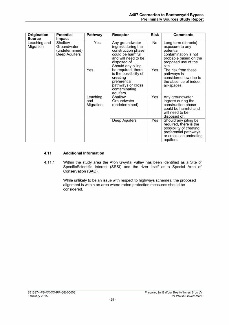
Origination Source
Potential Impact
Pathway Receptor Risk Comments
Off-site landfills.
(Inert, industrial, commercial, household, special waste, liquids or sludge wastes)
Soils impacted with heavy metals, sulphates, sulphides, hydrocarbons, and asbestos.
Direct contact (Ingestion & Dermal contact)
Site Users (road traffic) cyclists, occasional pedestrian (crossing the alignment on public footpaths)
No Long term (chronic) exposure to any potential contamination is not probable based on the proposed use of the site.
Inhalation of Dust
Yes The risk from these pathways is considered low due to the absence of indoor air-spaces
Leaching and Migration
Shallow Groundwater (undetermined)
Yes Any groundwater ingress during the construction phase could be harmful and will need to be disposed of.
Deep Aquifers Yes Should any piling be required, there is the possibility of creating preferential pathways or cross contaminating aquifers.
Methane, carbon dioxide and other soil gases
Off-site migration and build up in confined spaces
Occupants of buildings or confined spaces such as drainage manholes.
Yes No building are known to be included within the scheme, however there is a possibility of accumulation within future underground utilities/chambers
Site Users (road traffic) cyclists, occasional pedestrian (crossing the alignment on public footpaths)
No The risk from these pathways is considered low due to the absence of indoor air-spaces
Off-site Industrial Land Uses
(tanneries, mills, sewage works, etc)
Known and unidentified pollution events to groundwater
Leaching and Migration
Shallow Groundwater (undetermined)
Yes Any groundwater ingress during the construction phase could be harmful and will need to be disposed of.
Deep Aquifers Yes Should any piling be required, there is the possibility of creating preferential pathways or cross contaminating aquifers.
Former quarries and brick works
Made Ground of unknown source used to re-instate
Off-site migration and build up in confined spaces
Occupants of buildings or confined spaces such as drainage manholes.
Yes No building are known to be included within the scheme, however there is a possibility of accumulation within future underground utilities/chambers
A487 Caernarfon to Bontnewydd Bypass Preliminary Sources Study Report
3513874-PB-XX-XX-RP-GE-00003 Prepared by Balfour Beatty/Jones Bros JV
February 2015 for Welsh Government - 25 -
Origination Source
Potential Impact
Pathway Receptor Risk Comments
Leaching and Migration
Shallow Groundwater (undetermined) Deep Aquifers
Yes Any groundwater ingress during the construction phase could be harmful and will need to be disposed of. Should any piling be required, there is the possibility of creating preferential pathways or cross contaminating aquifers.
No Long term (chronic) exposure to any potential contamination is not probable based on the proposed use of the site.
Yes Yes The risk from these pathways is considered low due to the absence of indoor air-spaces
Leaching and Migration
Shallow Groundwater (undetermined)
Yes Any groundwater ingress during the construction phase could be harmful and will need to be disposed of.
Deep Aquifers Yes Should any piling be required, there is the possibility of creating preferential pathways or cross contaminating aquifers.
4.11 Additional Information
4.11.1 Within the study area the Afon Gwyrfai valley has been identified as a Site of SpecificScientific Interest (SSSI) and the river itself as a Special Area of Conservation (SAC).
While unlikely to be an issue with respect to highways schemes, the proposed alignment is within an area where radon protection measures should be considered.

A487 Caernarfon to Bontnewydd Bypass Preliminary Sources Study Report
3513874-PB-XX-XX-RP-GE-00003 Prepared by Balfour Beatty/Jones Bros JV
February 2015 for Welsh Government - 26 -

A487 Caernarfon to Bontnewydd Bypass Preliminary Sources Study Report
3513874-PB-XX-XX-RP-GE-00003 Prepared by Balfour Beatty/Jones Bros JV
February 2015 for Welsh Government - 27 -
SECTION 5
GROUND CONDITIONS

A487 Caernarfon to Bontnewydd Bypass Preliminary Sources Study Report
3513874-PB-XX-XX-RP-GE-00003 Prepared by Balfour Beatty/Jones Bros JV
February 2015 for Welsh Government - 28 -
5 GROUND CONDITIONS
5.1 Geology
5.1.1 Southern section (Ch0000-Ch3500)
Solid
5.1.2 The geology of the southern section is separated by a northeast to southwest trending fault running from Bontnewydd to the west of Llanwnda. Its exact location is not known. A small north/south trending fault exists to the east of the current A487 (Ref. 1), between Bontnewydd and Llanwnda, however this is unlikely to have any influence on the ground conditions due to its distance from the proposed alignment. It is possible there are other faults that have not been mapped within this section of the scheme. The majority of the section is characterised by the younger Silurian geological unit, the unit extends to approximately Ch1500-Ch2000 where it alternates to the older Cambrian unit (Ref. 7). The older rocks of Cambrian age are located to the south of the fault with younger Ordovician/Silurian rocks located to the north. The Cambrian rocks comprise the basal Conglomerate and Sandstone Division. The orientation of these rocks is unknown. The Silurian rocks comprise siltstones sandstones & conglomerate (Ref. 1).
Superficial
5.1.3 Updated information based upon unpublished geological maps (Ref. 6) indicates that that the corridor is predominantly underlain by Glacial Till intersected at intervals by Glaciofluvial, sheet, and hummocky diamicton deposits with a significant area located between Ch1700-Ch2500 in the vicinity of structure No 106. At the southernmost extents of this section (Ch0-Ch1000) it is indicated that peat deposits are present at two locations.
5.1.4 Alluvium deposits in the area of the Afon Gwyrfai are not shown on published maps but have been identified and are known to exist. The proposed alignment crosses the Afon Gwyrfai at approximately Ch2000.
5.1.5 See Figure 4 for Interpreted superficial geology map based upon best available information.
5.1.6 Central section (Ch3500-Ch6500)
Solid
5.1.7 The entirety of this section comprises rocks of Ordovician/ Lower Silurian age (Ref. 1). The Ordovician rocks comprise of interbedded grey-black shales, siltstones and thin, often calcerous fine-grained sandstones (Ref. 7). The Silurian consist of turbidite sandstones and Conglomerate dipping to the south at angles of around 30° to 50° (Ref. 1).
5.1.8 No faults have been identified in the vicinity of this section, however, it is possible there are other faults that have not been mapped.
Superficial Deposits
5.1.9 Updated information based upon unpublished geological maps (Ref. 6) indicates that the section is overlain predominantly by Glacial Till.

A487 Caernarfon to Bontnewydd Bypass Preliminary Sources Study Report
3513874-PB-XX-XX-RP-GE-00003 Prepared by Balfour Beatty/Jones Bros JV
February 2015 for Welsh Government - 29 -
5.1.10 Between Ch4500-Ch4900 the alignment borders the Seiont Quarry which is known to exibit exposures of Glacial Till overlain by Glaciofluvial sands and gravels.
5.1.11 Between Ch5000-Ch6000 the superficial geology is dominated by Glaciofluvial and Alluvial deposits consisting of gravels, silts and clay, returning to Till between Ch6000-Ch6500.
5.1.12 It is likely there are alluvium deposits in the proximity of the Afon Seiont that are not shown on the BGS map. The proposed alignment crosses the Afon Seiont at approximately Ch5500.
5.1.13 See figure 4 for Interpreted superficial geology map based upon best available information.
5.1.14 Northern Section (Ch6500-Ch9700)
Solid
5.1.15 The section comprises sedimentary rocks of Ordovician/Silurian age before running onto intrusive Felsic Igneous rock of the Pre Cambrian/Cambrian. This ingneous intrusion is characterised by Feldspar Porphory Quartz crystals (Ref. 1) but is not mapped in detail in the area of proposed road alignment. The Ordovician rocks comprise interbedded grey-black shales, siltstones and thin, often calcerous fine-grained sandstones. The Silurian rocks consist of turbidite sandstones and siltstones dipping to the south at angles of around 30° to 50° (Ref. 1). The Dinorwic Fault is the only major fault mapped in this section trending northeast-southwest separating the Arvonian Volcanic Series and the Red Measures. It is possible there are other faults that have not been mapped within this section.
Superficial Deposits
5.1.16 Updated information based upon unpublished geological maps (Ref. 6) indicates that the section is covered in Glacial Till (Boulder Clay) for the majority of its length between Ch6500-Ch10000. Till deposits are intersected by both Alluvium and Peat. A thin band of Alluvium intersects the Glacial Till at approximately Ch8000 near the intersection of the B4366. A more substantial area of peat has been identified as present running parallel to the proposed alignment between Ch8000-Ch8500.
5.1.17 It is likely there are alluvium deposits in the proximity of the Afon Cadnant that are not shown on the unpublished BGS map.
5.1.18 See figure 4 for Interpreted superficial geology map based upon best available information.

A487 Caernarfon to Bontnewydd Bypass Preliminary Sources Study Report
3513874-PB-XX-XX-RP-GE-00003 Prepared by Balfour Beatty/Jones Bros JV
February 2015 for Welsh Government - 30 -

A487 Caernarfon to Bontnewydd Bypass Preliminary Sources Study Report
3513874-PB-XX-XX-RP-GE-00003 Prepared by Balfour Beatty/Jones Bros JV
February 2015 for Welsh Government - 31 -
SECTION 6
PRELIMINARY ENGINEERING ASSESSMENT

A487 Caernarfon to Bontnewydd Bypass Preliminary Sources Study Report
3513874-PB-XX-XX-RP-GE-00003 Prepared by Balfour Beatty/Jones Bros JV
February 2015 for Welsh Government - 32 -
6 PRELIMINARY ENGINEERING ASSESSMENT
6.1 Southern section (Ch0-Ch3500)
6.1.1 The section covers wide open gently sloping ground that requires earthworks to provide a suitable level for highway construction. The southern section consists of a combination of embankment, cutting, at grade and structures as outlined below. See figure 2.
Ch0000-Ch650 – Embankment +8m
Ch185 – Structure (Underbridge – S101)
Ch545 – Structure (Underbridge – S102)
Ch650-Ch1200 – Cutting -9m
Ch840 – Structure (Overbridge –S103)
Ch1200-Ch1650 – Embankment +5m
Ch1320 – Structure (Pipe culvert – S104)
Ch1450 – Structure (Underbridge – S105)
Ch1650-Ch1750 – At Grade
Ch1750-Ch2100 – Structure (Viaduct – S106)
Ch2040 – Structure – (Sideroad underbridge – S107)
Ch2100-Ch3150 – Embankment +10m
Ch2290 – Structure (Underbridge – S108)
Ch2700 – Structure (Underbridge – S109)
Ch2930 – Structure (Underbridge – S110)
Ch3150-Ch3500 – At Grade
6.1.2 The underlying superficial deposits of Glacial Till should provide suitable founding strata for embankments in this section subject to a comprehensive ground investigation. Embankments should be stable with side slopes of 1:2 and loadings should not lead to excessive settlements or bearing capacity failure subject to a comprehensive ground investigation being undertaken and confirming suitable ground conditions. Gentler embankment slopes may be required if material is found to be of insufficient strength. A number of cuttings are also required in glacial deposits and possibly solid geology depending upon thickness of superficial deposits. Stable cutting slopes should be achievable at side slopes of 1:2 in glacial deposits and at 1:1.5 in solid geology depending upon weathering level and dip orientation. Slopes may be reduced to 1:3 if high groundwater levels cause the slope to become unstable. BGS mapping indicated that the Silurian Benarth Flag and Grits are dipping to the south at angles up to 50°. This may lead to instability in cuttings if the orientation of the beds is unfavourable to the face of the cutting.

A487 Caernarfon to Bontnewydd Bypass Preliminary Sources Study Report
3513874-PB-XX-XX-RP-GE-00003 Prepared by Balfour Beatty/Jones Bros JV
February 2015 for Welsh Government - 33 -
These may be stabilised in the form of rock dowels or ground anchors with appropriate mesh/netting.
6.1.3 A number of small roads that run adjacent to the proposed alignment require small crossing structures. It is likely that these structures can be founded on conventional spread foundations, although this will need to be confirmed by intrusive investigations. If unfavourable ground conditions are encountered within the glacial deposits, then deeper piled foundations may be required. Soft deposits are likely to be encountered between Ch0000-Ch1500, to provide suitable bearing capacity these will likely require a form of ground treatment.
6.1.4 The only major structures required in this section are for the crossing of the Afon Gwyrfai (Ch2000) and the Welsh Highland Railway (Ch2700). Conventional spread foundations may be used depending on the suitability of the underlying soils. Although there are no Alluvium deposits shown on the existing BGS maps it is likely they are present in the proximity of the Afon Gwyrfai. These deposits may contain soft alluvial clays and silts and possibly localised peat deposits that may lead to unacceptable settlements or bearing capacity failure. If Alluvium is encountered it is recommended that deeper piled foundations into suitable underlying strata are used founding in an adequate stratum that provide sufficient strength to withstand the loadings from this structure. A detailed ground investigation in this area will provide information on the alluvial deposits and will indicate which foundations are best suited.
6.1.5 The potential for re-use of site won material from this section will be determined from the assessment of the information supplied from a ground investigation and relevant materials testing.
6.2 Central section (Ch3500-Ch6500)
6.2.1 The section relates to the alignment running adjacent to Caernarfon stretching from Bontnewydd to the Cibyn industrial estate. The section is characterised by wide open gently sloping farmland in the southern section (Ch3500-Ch5000), then running near more industrialised areas including the perimeter of the Cibyn Industrial Estate , the A4086 Llanberis road, the A4085 and the Glan Gwna caravan park as well as the Afon Seiont. See figure 2.
6.2.2 The central section consists of a combination of embankment, cutting, at grade sections and structures as outlined below.
Ch3500 – Ch4350 – Embankment +6m
Ch3360 – Structure (Pipe culvert – S111)
Ch4040 – Structure (Underbridge – S112)
Ch4350 – Ch4750 – At Grade
Ch4750 – Ch5000 – Cutting -5m
Ch5000 – Ch5250 – Embankment +8m
Ch5300 – Structure (Viaduct – S113)
Ch5500-Ch6500 – At grade

A487 Caernarfon to Bontnewydd Bypass Preliminary Sources Study Report
3513874-PB-XX-XX-RP-GE-00003 Prepared by Balfour Beatty/Jones Bros JV
February 2015 for Welsh Government - 34 -
6.2.3 Embankments constructed on the glacial deposits should be stable with side slopes of 1:2 subject to a comprehensive ground investigation being undertaken and confirming ground conditions as suitable. Cuttings in the Glacial deposits should be stable with side slopes of 1:2 although drainage may be required in the sands and gravels due to the higher permeability of these deposits. Slopes may be reduced to 1:3 if high groundwater levels cause the slope to become unstable. Cuttings in rock formation should be stable with slopes at 1:1.5 subject to intrusive investigations. The Silurian Benarth Flag and Grits dip to the south at an angle of up to 50° as indicated by BGS mapping. This may lead to instability in the cuttings if the orientation of the beds is unfavourable to the face of the cutting. These may be stabilised with rock dowels and anchors with appropriate mesh/netting.
6.2.4 The only major structure required in this section will be to cross the valley of the Afon Seiont, this is proposed in the form of a viaduct. The location of the Peblig Industrial Estate and the village of Caeathro means that the alignment will run over the Glan Gwna caravan park. It is likely there are Alluvium deposits in the vicinity of the Afon Seiont that are not shown on the BGS map. Glaciofluvial deposits are also shown to be present in the vicinity of the proposed viaduct. Conventional spread foundations may be constructed to carry the columns of the viaduct subject to the underlying superficial deposits. Deeper piled foundations may be used if there are soft alluvial clays and silts and peat present founding into the deeper competent bedrock. This will be determined following a comprehensive ground investigation in the vicinity.
6.2.5 No soft peat deposits or compressible ground has been identified as being present along the central section of the alignment, however if soft deposits are encountered it is advised that ground treatment methods are used to improve ground conditions.
6.3 Northern section (Ch6500-Ch9700)
6.3.1 The section covers wide open undulated farmland stretching from Caeathro to the Plas Menai roundabout (Ch9700). The section consists of a combination of embankment, cutting, and structres. See figure 2.
Ch6500 – Ch8100 – Embankment
Ch8160 - Structure (Pipe culvert – S114)
Ch8100 – Ch8450 – Cutting -3m
Ch8350 – Structure (Underbridge – S115)
Ch8450 – Ch8770 – Embankment +3m
Ch8770 – Ch9700 Cutting -21m
Ch8900 – Structure (Pipe culvert – S116)
Ch8970 – Structure (Pipe culvert – S117)
Ch8970 – Structure (Overbridge – S118)
6.3.2 Embankments should be stable with side slopes of 1:2 and loadings should not lead to excessive settlements or bearing capacity failure. Cuttings in the glacial

A487 Caernarfon to Bontnewydd Bypass Preliminary Sources Study Report
3513874-PB-XX-XX-RP-GE-00003 Prepared by Balfour Beatty/Jones Bros JV
February 2015 for Welsh Government - 35 -
deposits should be stable with side slopes of 1:2 although drainage may be required in the sands and gravels due to the higher permeability of these deposits. Slope angles of cutting and embankments are subject to confirmation of ground conditions be a comprehensive ground investigation being undertaken. Slopes may be reduced to 1:3 if high groundwater levels cause the slope to become unstable. Cuttings in rock formation should be stable with slopes at 1:1.5 subject to assessment of the results of ground investigation and appropriate design. The Silurian Benarth Flag and Grits dip to the south at an angle of up to 50° as indicated by BGS mapping. This may lead to instability in the cuttings if the orientation of the beds is unfavourable to the face of the cutting. These may be stabilised with strengthened earthworks in the form of rock dowels and anchors with appropriate mesh/netting.
6.3.3 The material properties and bedding characteristics of the Plas Menai cutting will be determined by a comprehensive ground investigation along its proposed length. The extent of the cutting means that the material properties, structure, and discontinuity characteristics may vary along its length.
6.3.4 There is potential for a large amount of site won material to be gained from the Plas Menai cutting. The potential for re-use of site won material from this corridor will be determined from the assessment of the information supplied from a ground investigation.
6.3.5 Areas of soft Peat and/or soft compressible ground have been identified between Ch8000-Ch8500. When soft material is encountered it is advised that suitable ground treatment methods are used to improve ground conditions. This may include excavation and replacement with more competent material.

A487 Caernarfon to Bontnewydd Bypass Preliminary Sources Study Report
3513874-PB-XX-XX-RP-GE-00003 Prepared by Balfour Beatty/Jones Bros JV
February 2015 for Welsh Government - 36 -
SECTION 7
COMPARISON OF PROJECT OPTIONS AND RISKS

A487 Caernarfon to Bontnewydd Bypass Preliminary Sources Study Report
3513874-PB-XX-XX-RP-GE-00003 Prepared by Balfour Beatty/Jones Bros JV
February 2015 for Welsh Government - 37 -
7 COMPARISON OF PROJECT OPTIONS AND RISKS
7.1.1 The purpose of the geotechnical risk register is to highlight the risks and the consequence of those risks together with the measures taken to mitigate those risks. It is designed to be a living document to be updated as the ground investigations and detailed design are undertaken.
7.1.2 The scoring system used in the register is as follows.
Probability (P) Impact/
Consequence (I) Risk (PxI=R)
Risk Rating Response
Very likely 5 Very high 5 17 to 25 Intolerable Unacceptable
Probable 4 High 4 13 to 16 Intolerable Unacceptable
Likely 3 Medium 3 9 to 12 Substantial Early attention
Unlikely 2 Low 2 5 to 8 Tolerable Regular attention
Negligible 1 Very low 1 1 to 4 Trivial Monitor
Feature Hazard Before
Control Risk Control Measure (RCM)
After Control
P I R P I R
General Unknown archaeological finds made during works causing delays to programme.
2 2 4 Early identification of archaeological features or materials along corridor. Supervision of initial excavations.
1 2 2
Unidentified services causing delays/ obstructions during construction.
2 4 8 Early contact with utility providers, use of detection equipment, undertake service inspection pits.
1 4 4
Damage to existing services
2 4 8 Early contact with utility providers, appropriate design measures
1 4 4
Contaminated materials encountered causing delays and disposal/ treatment costs.
2 4 8 Sampling and testing of soils during ground investigation, including areas identified in desk studies as potential sources of contamination Appropriate treatment of any materials identified.
1 4 4
Buried obstructions causing delay.
2 3 6 Early identification during works by ground investigations if suspected
1 3 3

A487 Caernarfon to Bontnewydd Bypass Preliminary Sources Study Report
3513874-PB-XX-XX-RP-GE-00003 Prepared by Balfour Beatty/Jones Bros JV
February 2015 for Welsh Government - 38 -
Feature Hazard Before Control
Risk Control Measure (RCM)
After Control
P I R P I R
Aggressive ground conditions and sulphate attack on concrete.
2 4 8 Sampling and testing of soils during ground investigation. Implement all recommendations of BRE Special Digest 1.
1 4 4
Structures Excessive total or differential settlements of structure foundations.
2 4 8 Ground investigation and geotechnical testing of materials in area of foundations. Excavation for foundations to be inspected by an Engineering Geologist/ Geotechnical Engineer and deepened if required. Suitable foundation design.
1 4 4
Vibration during foundation construction causing damage to adjacent structures or destabilising adjacent slopes.
2 4 8 Identification of at-risk structures and slopes, use of low vibration plant, monitoring of vibrations during works.
1 4 4
Soft and compressible ground at formation level.
3 4 12 Ground investigation to identify depth and geotechnical properties of materials. Appropriate ground improvement techniques/Foundation design
1 4 4
Excavation earthworks
Instability of excavations due to pre-existing shear surfaces, and landslips, faulting and unfavourable hydrogeological conditions.
2 5 10 Ground investigation to identify areas of disturbance and geotechnical parameters. Appropriate design measures. Identify corridor alignment.
1 5 5
Vibration during excavation causing damage to adjacent structures or destabilising adjacent slopes.
2 4 8 Identification of at-risk structures and slopes, use of low vibration plant, monitoring of vibrations during works.
1 4 4

A487 Caernarfon to Bontnewydd Bypass Preliminary Sources Study Report
3513874-PB-XX-XX-RP-GE-00003 Prepared by Balfour Beatty/Jones Bros JV
February 2015 for Welsh Government - 39 -
Feature Hazard Before Control
Risk Control Measure (RCM)
After Control
P I R P I R
Unfavourable geological conditions causing delays in excavation of cuttings.
3 4 12 Comprehensive ground investigation to identify material properties of rock in areas of large cut
2 4 8
Embankment earthworks
Instability of embankments due to underlying soft and compressible materials, and materials with low shear strengths
3 4 12 Ground investigation to identify unsuitable materials and obtain geotechnical properties. Appropriate design measures and ground treatment.
1 4 4
Instability of embankments due to underlying shear surfaces, landslips and geological faults
2 4 8 Ground investigation to identify areas of disturbance and obtain geotechnical parameters. Appropriate design measures and ground treatment. Identify corridor alignment.
1 4 4
Embankment instability or failure due to unsuitable construction materials and design.
3 4 12 Geotechnical testing to obtain construction material properties. Appropriate design and stabilisation measures.
1 4 4
Failure of embankments is bearing pressure due to soft founding material.
3 4 12 Comprehensive ground investigation to identify areas of low bearing capacity. Material to be excavated and removed
1 4 4

3513874-PB-XX-XX-RP-GE-00003 Prepared by Balfour Beatty/Jones Bros JV February 2015 for Welsh Government
- 40 -
SECTION 8
REFERENCES

A487 Caernarfon to Bontnewydd Bypass Preliminary Sources Study Report
3513874-PB-XX-XX-RP-GE-00003 Prepared by Balfour Beatty/Jones Bros JV February 2015 for Welsh Government
- 41 -
8 REFERENCES
1) British Geological Survey, Carnarvon, Sheet 78 Old Series, 1852, Solid, One inch scale
2) Envirocheck Report, Caernarfon Study Area, 2009.
3) B. Roberts, 1979, The Geology of Snowdonia and Llyn: An Outline and Field Guide
4) J. B Whittow., 1970, The Glaciations of Wales and Adjoining Regions, edited by Colin A Lewis, North-West Wales
5) E. Greenly, 1941, Notes on the glacial phenomena of Arvon
6) BGS unpublished map. Nefyn Sheet 118.
7) BGS Geology of Britain viewer. (Accessed February 2015

A487 CAERNARFON TO
BONTNEWYDD BYPASS
ANNEX A TO PSSR
Welsh Government
3513874-PB-XX-XX-RP-GE-00002
FINAL

A487 Caernarfon to Bontnewydd Bypass Annex A to PSSR
3513874-PB-XX-XX-RP-GE-00002 Prepared by Jones Bros. Balfour Beatty JV
January 2015 for Welsh Government
A487 Caernarfon to Bontnewydd Bypass
Annex A to PSSR
3513874-PB-XX-XX-RP-GE-00002
Prepared for Welsh Government
Sar Mynach Llandudno Junction
Conwy LL31 9RZ
Prepared by Jones Bros. Balfour Beatty JV
Ty Glyn, Canol Y Dre Ruthin LL15 1QW
Telephone 01824 703661

A487 Caernarfon to Bontnewydd Bypass Annex A to PSSR
3513874-PB-XX-XX-RP-GE-00002 Prepared by Jones Bros. Balfour Beatty JV
January 2015 for Welsh Government
Report Title : A487 Caernarfon to Bontnewydd Bypass Annex A to PSSR Doc Number : 3513874-PB-XX-XX-RP-GE-00002 Report Status : FINAL Job No : 3513874A-HHC Date : January 2015
DOCUMENT HISTORY AND STATUS
Document control
Prepared by Guy Swains Checked by (technical)
Kevin Power
Approved by Russell Bennett Checked by (quality assurance)
Kate Attwood
Revision details
Version Date Pages
affected Comments
P01 22/01/2015 Issued for Comment
P02 06/08/2015 Following ooga comments

A487 Caernarfon to Bontnewydd Bypass Annex A to PSSR
3513874-PB-XX-XX-RP-GE-00002 Prepared by Jones Bros. Balfour Beatty JV
January 2015 for Welsh Government
CONTENTS Page
1 Objectives and Format of Any Investigation 5
2 Special problems to be investigated 5
3 Proposed Investigation 6
4 Site & Working Restrictions 11
5 Specialist Consultation 11
6 Programme, Cost and Contract Arrangement 11
7 Reporting 11
APPENDICES Appendix A Site Location Plan

A487 Caernarfon to Bontnewydd Bypass Annex A to PSSR
3513874-PB-XX-XX-RP-GE-00002 Prepared by Jones Bros. Balfour Beatty JV
January 2015 for Welsh Government
1 OBJECTIVES AND FORMAT OF ANY INVESTIGATION
1.1.1 It is proposed to construct a bypass from the north of Caernarfon to south of Bontnewydd. The proposed scheme is some 9.5km in length. The new road will provide localised access to towns, farms and other highways in the area whilst diverting traffic from the existing A487 trunk road.
1.1.2 There are a number of proposed major engineering features on the route including cuttings, embankments and structures, as the proposed scheme runs from the south-east to north-east of Caernarfon, North Wales.
1.1.3 Proposed ground investigations are to provide information to clarify geotechnical, geomorphological and geo-environmental findings of the Preliminary Sources Study, as reported separately. Investigations are designed as such to obtain detailed knowledge of the soils, solid geology, land contamination groundwater regime encountered and their likely behaviour and acceptability.
2 SPECIAL PROBLEMS TO BE INVESTIGATED
2.1.1 Proposed ground investigations have been designed as per the guidelines set out within BS EN1997 for a linear structure to provide scheme wide ground conditions. Furthermore, proposed ground investigations have been designed to target areas where specific and detailed information is required; such as areas associated with proposed structures, cuttings and embankments. Table 1.1, highlights the proposed structures along the alignment where targeted ground investigation is required.
Table 1.1: Structures and Earthworks Requiring Targeted Ground Investigation
Structure Name Type Chainage
ST101 Unnamed watercourse Underbridge 0185
ST102 River Rhyd Underbridge 0545
ST103 Proposed Road Overbridge 0840
ST104 Unnamed watercourse Pipe Culvert 1320
ST105 Farm access lane Underbridge 1450
ST106 River Gwyrfai Viaduct 2040
ST107 Side road Underbridge 2290
ST108 Welsh Highland railway Underbridge 2700
ST109 Side road Underbridge 2930
ST110 Unnamed watercourse Pipe Culvert 3660
ST111 Penybryn Road Underbridge 4040
ST112 A4085 River Seiont Viaduct 5300
ST113 Proposed Road Overbridge 7850
ST114 River Cadnant Pipe Culvert 8160
ST115 B4366 Underbridge 8350
ST116 Unnamed watercourse Pipe Culvert 8900
ST117 Proposed road Overbridge 8970
ST118 Unnamed watercourse Pipe Culvert 8970
Earthwork Name Type Chainage
EW101 Problematic geology Cutting 0900-1400
EW102 Problematic geology Embankment 8000-8500
EW103 Rock Investigation Rock Cut 8900-9510

A487 Caernarfon to Bontnewydd Bypass Annex A to PSSR
3513874-PB-XX-XX-RP-GE-00002 Prepared by Jones Bros. Balfour Beatty JV
January 2015 for Welsh Government
2.1.2 Earthwork EW102 is proposed to be constructed over an area identified in the PSSR as being underlain by unknown depths of peat and/or soft compressible sediments. A number of exploratory holes have been scheduled in this area to confirm the thickness of the compressible sediments and obtain high quality samples order to enable detailed logging and laboratory testing.
2.1.3 Towards the northern extent of the scheme Earthwork EW103 (Plas Menai cutting) is a proposed rock cut where the road alignment is significantly deeper than the existing ground levels. Exploratory boreholes are proposed in this area to enable detailed logging of the strata and collection of samples for detailed laboratory testing. The number of boreholes proposed in this area reflects the requirement for high sample volume required to complete bespoke testing suites to access the suitability of the rock for use as engineering fill and concrete aggregate. It is further proposed to use acoustic and optical down borehole geophysics to map, log and detail the discontinuities to assess in-situ rock structure for the purpose of examining cutting stability.
2.1.4 Additionally, areas have been identified where localised contamination associated with historic landfills may exist. Targeted geo-environmental investigation, testing and reporting will be undertaken.
2.1.5 Although at Chainage 4500 to 4900 the alignment runs adjacent to an active quarry, the scheme will not impact on the quarry highwalls. However, this will be confirmed. The ground investigation has been designed to target any potential issues in the immediate vicinity of the quarry.
3 PROPOSED INVESTIGATION
3.1.1 The proposed investigation comprises 81 boreholes in total; 7 exclusively cable percussively progressed boreholes, 67 cable percussive boreholes with rotary coring through solid geology, 7 dynamically (continuously) sampled boreholes with rotary coring through solid geology and 69 machine excavated trial pits. Additionally 22 California bearing ratio in-situ tests are proposed to inform pavement design and 10 soil infiltration tests to assess permeability of the ground encountered.
3.1.2 Tables 3.1 below details the type of exploratory hole, anticipated geology, structure identity, approximate chainage and structure type.
3.1.3 Boreholes at all structure locations will be terminated at solid geology +3.00m. Boreholes at pier locations of viaducts will be terminated at solid geology +6.00m to satisfy eurocode requirements.
3.1.4 Further included at the end of this document is the proposed Exploratory Hole Location Plan; Drawing 14014-PB-06-ZZ-DR-C-0003 A.
Table 3.1: Proposed Exploratory Hole Schedule
Hole ID No.
Type Anticipated Superficial Geology
Structure No. Chainage Structure Type
BH1 CP / RC PEAT S101 200 Underbridge
BH2 CP / RC PEAT S101A 400 Underbridge
BH3 CP / RC PEAT S101A
BH4 CP / RC TILL S102 550 Underbridge

A487 Caernarfon to Bontnewydd Bypass Annex A to PSSR
3513874-PB-XX-XX-RP-GE-00002 Prepared by Jones Bros. Balfour Beatty JV
January 2015 for Welsh Government
BH5 CP / RC TILL S102
BH6 CP / RC TILL S103 / EW101 850 Overbridge
BH7 CP / RC TILL S103 / EW101
BH8 CP / RC PEAT EW101 950 Cutting
BH9 CP TILL S104 1300 Pipe Culvert
Hole ID No.
Type Anticipated Superficial Geology
Structure No. Chainage Structure Type
BH10 CP / RC TILL S105 1500
Underbridge BH11 CP / RC TILL S105 1500
BH12 CP / RC TILL S105 1500
BH13 CP / RC TILL S105 1500
BH14 CP / RC ALV S106 1900-2100
Viaduct BH15 CP / RC ALV S106
BH16 CP / RC ALV S106
1900-2100
Viaduct
BH17 CP / RC ALV S106
BH18 CP / RC ALV S106
BH19 CP / RC ALV S106
BH20 CP / RC ALV S106
BH21 CP / RC ALV S106
BH22 CP / RC ALV S106
BH23 CP / RC ALV S106
BH24 CP / RC ALV S106
BH25 CP / RC ALV S106
BH26 CP / RC ALV S106
BH27 CP / RC ALV S106
BH28 CP / RC ALV S106
BH29 CP / RC TILL S107 2300 Underbridge
BH30 CP / RC TILL S107 2300
BH31 CP / RC TILL S108 2700
Underbridge BH32 CP / RC TILL S108 2700
BH33 CP / RC TILL S108 2700
BH34 CP / RC TILL S108 2700
BH35 CP / RC TILL S109 3000
Underbridge BH36 CP / RC TILL S109 3000
BH37 CP / RC TILL S109 3000
BH38 CP / RC TILL S109 3000
BH39 CP / RC TILL S110 3650 Pipe Culvert
BH40 CP / RC TILL S111 4000 Underbridge
BH41 CP / RC TILL S111 4100
BH42 CP TILL Alignment 4500 Adjacent to

A487 Caernarfon to Bontnewydd Bypass Annex A to PSSR
3513874-PB-XX-XX-RP-GE-00002 Prepared by Jones Bros. Balfour Beatty JV
January 2015 for Welsh Government
BH43 CP TILL Alignment 4600 Quarry
BH44 CP TILL Alignment 4900 Cutting
BH45 CP / RC GFTD S112 5400-5600
Viaduct BH46 CP / RC GFTD S112
BH47 CP / RC GFTD S112
Hole ID No.
Type Anticipated Superficial Geology
Structure No. Chainage Structure Type
BH48 CP / RC GFTD S112
5400-5600
Viaduct
BH49 CP / RC RTDU S112
BH50 CP / RC RTDU S112
BH51 CP / RC RTDU S112
BH52 CP / RC RTDU S112
BH53 CP / RC RTDU S112
BH54 CP / RC RTDU S112
BH55 CP / RC ALV S112
BH56 CP / RC ALV S112
BH57 CP / RC ALV S112
5400-5600
Viaduct
BH58 CP / RC ALV S112
BH59 CP / RC ALV S112
BH60 CP / RC ALV S112
BH61 CP / RC ALV S112
BH62 CP / RC ALV S112
BH63 CP TILL Alignment 6500 Roundabout
BH63A CP TILL Alignment 6500 Roundabout
BH63B CP TILL Alignment 6400 At Grade
BH64 CP TILL Alignment 7750 Cutting
BH65 CP TILL Alignment 7770 Cutting
BH66 CP PEAT S114 / EW102 8250 Pipe Culvert
BH67 CP / RC PEAT S115 / EW102 8400
Underbridge BH68 CP / RC PEAT S115 / EW102 8450
BH69 CP / RC PEAT S115 / EW102 8400
BH70 CP / RC PEAT S115 / EW102 8450
BH71 CP / RC TILL S116 8400 Pipe Culvert
BH72 CP / RC TILL S117 8450
Overbridge BH73 CP / RC TILL S117 9000
BH74 CP / RC TILL S117 9000
BH75 CP / RC TILL S117 / S118 9100 Overbridge
BH76 DS / RC TILL EW103 9150
Cutting BH77 DS / RC TILL EW103 9250
BH77A DS / RC TILL EW103 9275

A487 Caernarfon to Bontnewydd Bypass Annex A to PSSR
3513874-PB-XX-XX-RP-GE-00002 Prepared by Jones Bros. Balfour Beatty JV
January 2015 for Welsh Government
BH78 DS / RC TILL EW103 9300
BH78A DS / RC TILL EW103 9400
BH79 DS / RC TILL EW103 9500
BH79A DS / RC TILL EW103 9500
TP1 TP HGD Alignment 50 Roundabout
TP2 TP PEAT S101 150 Embankment
TP3 TP / SA HGD S101A 400 Pipe Culvert
TP4 TP / CBR ALV S102 500 At grade
Hole ID No.
Type Anticipated Superficial Geology
Structure No. Chainage Structure Type
TP5 TP / CBR TILL Alignment 600 At grade
TP6 TP / CBR TILL Alignment 650 At grade
TP7 TP / CBR TILL S103 / EW101 750 Cutting
TP8 TP TILL EW101 850 Cutting
TP9 TP / CBR TILL EW101 1000 Cutting
TP10 TP TILL Alignment 1250 Embankment
TP11 TP / CBR TILL Alignment 1600 At grade
TP12 TP / CBR / SA ALV Alignment 1750 At grade
TP13 TP ALV S106
1900-2100
Viaduct TP14 TP ALV S106
TP15 TP ALV S106
TP16 TP ALV S106
TP17 TP ALV S106 1900-2100
Viaduct TP18 TP ALV S106
TP19 TP / SA GFSD Alignment 2200 Embankment
TP20 TP TILL S107 2250 Embankment
TP21 TP TILL Alignment 2500 Embankment
TP22 TP TILL Alignment 2550 Embankment
TP23 TP TILL S108 2600 Embankment
TP24 TP TILL Alignment 2750 Embankment
TP25 TP TILL S109A 2850 Pipe Culvert
TP26 TP / CBR TILL Alignment 3200 At grade
TP27 TP / CBR TILL Alignment 3400 At grade
TP28 TP TILL S110A 3500 Pipe Culvert
TP29 TP / CBR TILL Alignment 3500 Roundabout
TP30 TP TILL S110 3500 Embankment
TP31 TP TILL Alignment 3650 Embankment
TP32 TP TILL Alignment 3800 Embankment
TP33 TP TILL S111 4050 Embankment
TP34 TP TILL Alignment 4200 Embankment

A487 Caernarfon to Bontnewydd Bypass Annex A to PSSR
3513874-PB-XX-XX-RP-GE-00002 Prepared by Jones Bros. Balfour Beatty JV
January 2015 for Welsh Government
TP35 TP / CBR / SA TILL Alignment 4350 At grade
TP36 TP / CBR TILL Alignment 4600 At grade
TP37 TP / CBR TILL Alignment 4700 At grade
TP38 TP TILL Alignment 4850 Cutting
TP39 TP GFTD Alignment 5200 Embankment
TP40 TP / SA GFTD S112 5300 Embankment
TP41 TP RTDU S112 5400 Viaduct
TP42 TP RTDU S112 5450 Viaduct
Hole ID No.
Type Anticipated Superficial Geology
Structure No. Chainage Structure Type
TP43 TP / SA TILL Alignment 5650 Embankment
TP44 TP TILL Alignment 5750 Embankment
TP45 TP TILL Alignment 5800 Embankment
TP46 TP / CBR TILL Alignment 5900 At grade
TP47 TP TILL Alignment 6150 Embankment
TP48 TP TILL Alignment 6250 Embankment
TP49 TP TILL Alignment 6400 Embankment
TP49A TP TILL Alignment 6500 Roundabout
TP49B TP TILL Alignment 6400 Roundabout
TP50 TP / CBR / SA TILL Alignment 6500 Roundabout
TP51 TP / CBR / SA TILL Alignment 6650 At grade
TP51A TP TILL Alignment 6575 At grade
TP52 TP / CBR TILL Alignment 6750 At grade
TP53 TP / CBR TILL Alignment 6850 At grade
TP54 TP / CBR TILL Alignment 7000 At grade
TP55 TP / CBR TILL Alignment 7100 At grade
TP56 TP TILL Alignment 7300 Embankment
TP57 TP TILL Alignment 7450 Embankment
TP58 TP TILL Alignment 7650 Embankment
TP59 TP TILL Alignment 8000 Slip road
TP60 TP / SA TILL S114 8100 Embankment
TP61 TP PEAT S114 / EW102 8200 Embankment
TP62 TP PEAT EW102 8600 Embankment
TP63 TP PEAT EW102 8700 Embankment
TP64 TP TILL S116 8900 Roundabout
TP65 TP / CBR / SA TILL EW103 9800 Roundabout
TP66 TP / CBR TILL EW103 9800 Roundabout
Key:
• Exploratory Hole Type and Method • Anticipated Geology
BH Borehole ALV Alluvium (Gravel, Silt and Clay)

A487 Caernarfon to Bontnewydd Bypass Annex A to PSSR
3513874-PB-XX-XX-RP-GE-00002 Prepared by Jones Bros. Balfour Beatty JV
January 2015 for Welsh Government
TP Trail Pit GFTD Terrace Deposits (Sand and Gravel)
CBR California Bearing Ratio Test (In-Situ)
HGD Hummocky Glacial Deposits (Diamicton)
CP Cable Percussive PEAT Peat and Compressible Ground
DS Dynamically/Continuously Sampled
RTDU River Terrace Deposits
RC Rotary Cored TILL Glacial Till
SA Soil Infiltration Test
TP Machine Excavated trial Pits
4 SITE & WORKING RESTRICTIONS
4.1.1 Works on site, during the ground investigation, will be restricted to the working hours as set by the Contract Information. Access to private land will be agreed in advance.
5 SPECIALIST CONSULTATION
5.1.1 No specialist consultation is currently planned to be undertaken. The need for such provision will be kept under review for the duration of the scheme and should a reason arise that indicates the need for specialist advice, this will be sought.
6 PROGRAMME, COST AND CONTRACT ARRANGEMENT
6.1.1 All costs associated with the ground investigation were contained within the Joint Venture; Balfour Beatty/Jones Brothers. Parsons Brinckerhoff will be responsible for providing technical direction during the length of the ground investigation works. BB/JB joint venture will take the role of investigation supervisor.
6.1.2 The proposed Ground Investigation will be procured by the Joint Venture, who will be further responsible for the programme and management of the ground investigation.
7 REPORTING
7.1.1 All reporting of the works will be in accordance with HD22/08 "Managing Geotechnical Risk”. Reporting up until the end of Key Stage 3 will be as follows:
A single Ground Investigation Report (GIR) for the total alignment length separated into appropriate sections (sections to be confirmed) will be produced based upon the information and data obtained through the proposed ground investigation and other sources identified in the PSSR.
A single Geotechnical Design Report (GDR) will be produced for the alignment, earthworks and associated structures.
7.1.2 All reports will be prepared in accordance with HD22/08 and certified by the Design Geotechnical Advisor on behalf of PB.
7.1.3 PB are the Joint Ventures Designer for Key Stage 3.

A487 CAERNARFON AND BONTNEWYDD BYPASS
Appendix F.2 – Hydrogeology Desk Study

A487 CAERNARFON AND BONTNEWYDD BYPASS

February 2016
A487 CAERNARFON AND
BONTNEWYDD BYPASS
HYDROGEOLOGICAL DESK STUDY
Balfour Beatty Construction Services UK
3513874A.3229Draft

A487 Caernarfon andBontnewydd Bypass
Hydrogeological Desk Study
3513874A.3229
Prepared forBalfour Beatty Construction Services UK
Sutton Quays Business ParkOff Clifton RoadSutton Weaver
CheshireWA7 3EH
Prepared byParsons Brinckerhoff
Manchester Technology CentreOxford RoadManchester
M1 7ED
0161 200 5000www.pbworld.com

Report Title : A487 Caernarfon and Bontnewydd BypassHydrogeological Desk Study
Report Status : Draft
Job No : 3513874A
Date : February 2016
DOCUMENT HISTORY AND STATUS
Document control
Prepared by Martin Lucass Checked by(technical) Duncan Cartwright
Approved by Duncan Cartwright Checked by(quality assurance) Duncan Cartwright
Revision details
Version Date Pagesaffected Comments
1.0 October2015 - First Issue
2.0 February2016 Various Monitoring points revised following updated data sets.

A487 Caernarfon and BontnewyddBypass Hydrogeological Desk Study
3513874A.3229 A487 Caernarfon and Bontnewydd Hydrogeological Desk Study v2 Prepared by WSP | Parsons BrinckerhoffFebruary 2016 for Balfour Beatty Construction Services UK
- iv -
CONTENTSPage
1 INTRODUCTION 11.1 Appointment 11.2 Background 11.3 Objectives and Scope of Work 11.4 Limitations 2
2 GEOLOGY AND HYDROGEOLOGY 32.2 Bedrock Geology 32.3 Superficial Geology 52.4 Groundwater Abstraction Potential 62.5 Summary 7
3 ABSTRACTION SURVEY 83.2 Survey Strategy 83.3 Survey Results 83.4 Survey Summary 9
4 POTENTIAL GROUNDWATER IMPACTS 114.2 Likely Impacts on Springs, Wells and Boreholes 11
5 SUMMARY 125.2 Deep Aquifers 125.3 Shallow Aquifers 125.4 Groundwater Abstractions 125.5 Other Considerations 12
6 RECOMMENDATIONS 14
Appendix A
Figures 1- 11 Private Abstractions

A487 Caernarfon and BontnewyddBypass Hydrogeological Desk Study
3513874A.3229 A487 Caernarfon and Bontnewydd Hydrogeological Desk Study v2 Prepared by WSP | Parsons BrinckerhoffFebruary 2016 for Balfour Beatty Construction Services UK
- 1 -
1 INTRODUCTION
1.1 Appointment
1.1.1 Full details regarding the appointment are contained within the EnvironmentalStatement. The remit of this report is as follows. As the proposed bypass road isconstructed, the groundwater regime is expected to be modified in areas wherecuttings are created or embankments are placed. This hydrogeological desk studyprovides information regarding groundwater and its use within a 300 m corridor of theproposed route of the bypass. This report is intended to provide information for futurephases of the scheme to adequately protect groundwater or mitigate against potentialadverse impacts.
1.2 Background
1.2.1 Full details regarding the project area and background are contained within theEnvironmental Statement. A brief summary is provided below.
1.2.2 The study area is situated in north west Wales in the county of Gwynedd, to the southeast of Caernarfon (Grid Ref: 48040 62700). The proposed route extends over adistance of 9.8 km from north of Caernarfon to the south of Bontnewydd. For this deskstudy the study area is defined as a 300 m corridor and stretches from approximately500 m south of Llanwnda to the Felinheli/Plas Menai, bypassing the town ofCaernarfon as well as the villages of Llanwnda and Bontnewydd.
1.2.3 The majority of the land is used for sheep and cattle grazing. Cibyn industrial estate ispresent in the central area located south of Caernarfon. The landscape aroundCaernarfon can be described as gently rolling hills, generally sloping towards thecoast to the northwest. There are two major rivers including the Afon Gwyrfai and theAfon Seiont as well as small pockets of woodland, generally confined to the valleys ofthese rivers.
1.3 Objectives and Scope of Work
1.3.1 The principal objectives of the hydrogeological desk study are to summarise allpublished information relating to groundwater and undertake an abstraction survey ofall land within 300 m of the route to establish the number and use of abstractions. Toachieve this objective the following scope of works has been completed:
· Desk based review of published data sources;
· Abstraction Survey; and
· Production of a register of potentially impacted abstractions.
1.3.2 The desk study has been completed using information from Natural Resources Walesand Gwynedd Council as well as published information. A full list of data sources isprovided below:
· Review of historical maps and published geological, hydrogeological andtopographical information;
· Information provided by Natural Resources Wales;
· Information provided by Gwynedd Local Authority;
· Landowner abstractions questionnaire;

A487 Caernarfon and BontnewyddBypass Hydrogeological Desk Study
3513874A.3229 A487 Caernarfon and Bontnewydd Hydrogeological Desk Study v2 Prepared by WSP | Parsons BrinckerhoffFebruary 2016 for Balfour Beatty Construction Services UK
- 2 -
· Site walkover; and
· Landowner meetings.
1.4 Limitations
1.4.1 The report may be relied upon by Balfour Beatty Construction Services UK, as “theClient”. This report has been completed with regard to generally accepted consultingpractices and may not be relied upon by any other party without the explicit writtenagreement of WSP | Parsons Brinckerhoff. No other third party warranty, expressedor implied, is made as to the professional advice included in this report. This reportmust be used in this entirety.
1.4.2 The assessments made herein assume that the route of the bypass is option 2, asspecified in the specification for site investigation version 4. Should any change to thefuture land use take place following issue of the report then the conclusions andrecommendations of this report may need to be re-assessed.
1.4.3 All information is provided to the best of our knowledge and no warranty orrepresentation is provided as to its accuracy or completeness.WSP | Parsons Brinckerhoff takes no responsibility for the quality of the workprovided to us by any third parties on which our interpretation is based.

A487 Caernarfon and BontnewyddBypass Hydrogeological Desk Study
3513874A.3229 A487 Caernarfon and Bontnewydd Hydrogeological Desk Study v2 Prepared by WSP | Parsons BrinckerhoffFebruary 2016 for Balfour Beatty Construction Services UK
- 3 -
2 GEOLOGY AND HYDROGEOLOGY
2.1.1 The following published sources have been used to summarise geological andhydrogeological information for the proposed route:
· British Geological Survey - Sheet 1: Hydrogeological Map of England and Wales(1:625,000) – 1997;
· British Geological Survey 1:50,000 Series – England and Wales Sheet 106,Bangor, Solid Geology, 1985;
· British Geological Survey 1:63,360 Series – England and Wales Sheet 78SW,South of Holyhead Island and of Anglesey, Caernarvon. Coal Measures. SolidGeology, April 1852, variant 4;
· British Geological Survey, 1:625,000 scale digital hydrogeological data onlineviewer; and
· British Geological Survey, GeoIndex Onshore, online viewer.
2.1.2 Prior to any ground investigation as part of the scheme, there were no availableborehole records for the proposed corridor with the exception of a small numberlocated at the northern connection with the existing A487. These were drilled as partof a previous phase of upgrade for the A487.
2.1.3 A full summary of the geology is provided within the Ground Investigation Report. Thisreport also refers to the newly created 1:50 000 geology sheet ‘Sheet 118 & part of105 Nefyn and part of Caernarfon, 2015’, which has yet to be published at the time ofwriting, as well as summarising information obtained from the ground investigationcompleted as part of the scope.
2.2 Bedrock Geology
2.2.1 From south to north the geology can be summarised as shown in the table below. Thegeology of the area is defined by the close proximity to the Menai Straight FaultSystem. As a result, a number of north east – south west faults form boundariesbetween geological formations. Specifically, two major faults named the Aber-DinlleFault’ and ‘Dinorwic Fault’ separate the older Pre-Cambrian rocks from the youngerOrdivician and Carboniferous rocks.
2.2.2 From south to north based upon the BGS solid geology map for the adjacent regionare the following bedrock strata and their corresponding aquifer classification fromsouth to north across the proposed route.
Table 2.1 Bedrock Geology Information
BedrockGeology
Description AquiferClassification
1:625,000 BedrockClassification
PardarnTuffFormation –Tuff –Felsic
Present along the AberDinlle Fault stretching northeast to south westcomprising fine ash flowtuff’s. Outcrops frequentlybetween the Aber Dinlle faultand the Ceriniog fault tothicknesses of at least1000 m.
Secondary AUnnamed ExtrusiveRock, Neoproterzoic –Felsic Tuff

A487 Caernarfon and BontnewyddBypass Hydrogeological Desk Study
3513874A.3229 A487 Caernarfon and Bontnewydd Hydrogeological Desk Study v2 Prepared by WSP | Parsons BrinckerhoffFebruary 2016 for Balfour Beatty Construction Services UK
- 4 -
BedrockGeology
Description AquiferClassification
1:625,000 BedrockClassification
FachwenFormation –Siltstone &Limestone,Interbedded
Fine to coarse clasticsediments derived fromsurrounding igneousgeology. Coarseconglomerate unitscomprised of tuff clasts arefrequent. This unit is up to500 m in thickness to thesouth of the Aber DinlleFault.
Secondary B
Lower Cambrian Rock(undifferentiated) –Sandstone andConglomerate,Interbedded
NantFfrancanSubgroup -Siltstone
900 m of interbeddedsiltstone and mudstone.Bound by the Aber Dinllefault to the south it dominantbedrock along the route.
Secondary B
Llanvirin Rocks(Undifferentiated) –Mudstone, Siltstoneand Sandstone
Allt LwydFormation –Sandstone
Interbedded siltstone andcoarse- to medium-grained,bioturbated and locallyslumped sandstone, locallyquartzose or volcaniclastic,subordinate conglomerateand rare mudstones.
Secondary A
Unnamed IgneousIntrusion, Ordovicianto Silurian – Felsic-RockUnnamed
IgneousIntrusion,Ordovician- Granite
No description available.
Secondary B
2.2.3 The majority of the route is underlain by Secondary B bedrock aquifers but alsopasses over secondary A aquifers. The Environment Agency classifies secondary Aand secondary B aquifers as follows:
· Secondary A – permeable layers capable of supporting water supplies at a localrather than strategic scale, and in some cases forming an important base flow torivers. These are generally aquifers classified as minor aquifer; and
· Secondary B - pre predominantly lower permeability layers which may store andyield limited amounts of groundwater due to localised features such as fissures,thin permeable horizons and weathering. These are generally the water-bearingparts of the former non-aquifers.
2.2.4 The UK Hydrogeology viewer provides the following additional information aboutaquifer potential:
· Lower Cambrian Rocks (undifferentiated) – Low productivity aquifer. Highlyindurated (hardened) rocks with limited groundwater in near surface weatheredzone and secondary fractures;
· Llanvirin Rocks (Undifferentiated) – Low productivity aquifer. Highly induratedrocks with limited groundwater;

A487 Caernarfon and BontnewyddBypass Hydrogeological Desk Study
3513874A.3229 A487 Caernarfon and Bontnewydd Hydrogeological Desk Study v2 Prepared by WSP | Parsons BrinckerhoffFebruary 2016 for Balfour Beatty Construction Services UK
- 5 -
· Unnamed Igneous Intrusion, Ordovician to Silurian – Low productivity aquifer.Small amounts of groundwater in near surface weathered zone and secondaryfractures; rare springs.
2.2.5 In summary, there is limited resource potential with respect to bedrock aquifers.
2.3 Superficial Geology
The majority of the proposed alignment is underlain by Glacial Till. The till varies incomposition constituting clays, silt, sand, gravel, cobbles and inclusions of boulders ofvarying size. Information provided by the ground investigation indicates that GlacialTill and/or River Terrace deposits were encountered in the majority of locationscomprising predominantly gravel and clay. A number of other superficial depositsincluding alluvium, where rivers are present, and peat are also expected.Corresponding aquifer types are provided in the below table. Approximations havealso been made for the length of the scheme where each superficial geologyformation will be present.
Table 2.2 Superficial Geology Information
Superficial Geology Aquifer ClassificationApproximate length ofroute underlain bysuperficial geology
Till - Diamicton Secondary A 9,700 m
Alluvium (Gravel, Silt andClay)
Secondary A 585 m
Glaciofluvial Deposits Secondary A 340 m
Hummocky GlacialDeposits
Secondary A 245 m
River Terrace Deposits Secondary A 55 m
2.3.1 The majority of the route is underlain by Glacial Till. In addition to this, approximately15 % of the route is also underlain by other superficial deposits which can besubdivided into three key areas:
· At the southern end of the route both Glaciofluvial and alluvial deposits arepresent, associated with historic glaciation and existing unnamed surface watercourses.
· A second area of alluvial deposits is present as the route crosses the AfonGwyrfai river where the river has significant meanders resulting in a large area ofalluvial material (approximately 450 m width).
· The third area covers a distance of approximately 470 m and comprises a seriesof deposits including Glaciofluvial deposits, river terrace deposits and alluvium asthe route crosses the Afon Seiont river, which has a floodplain to the south. TheGlaciofluvial deposits have been removed locally at the Seiont Quarry adjacentto the proposed route.
2.3.2 In addition to the above there are some areas of Raised Tidal Flat Deposits in thevicinity, but they are not expected to be present in the proposed road alignment. TheBGS describes them as silt, clay and fine-grained sand with lenses of gravel. It istherefore possible that groundwater is able to flow within this strata, however as they

A487 Caernarfon and BontnewyddBypass Hydrogeological Desk Study
3513874A.3229 A487 Caernarfon and Bontnewydd Hydrogeological Desk Study v2 Prepared by WSP | Parsons BrinckerhoffFebruary 2016 for Balfour Beatty Construction Services UK
- 6 -
are not continuous over large distances it is unlikely to form a major component ofgroundwater flow in the area.
2.3.3 Peat has also been identified in the scheme area but not specifically during groundinvestigation. Should peat be present, it is not considered to be a viable groundwaterresource as it is rarely present to a significant depth and has unsuitable water quality(i.e. it has high suspended sediment load). The Environment Agency classifies this asunproductive strata. The peat, however, is sensitive to changes in groundwaterregime and future road construction could affect it, if it is subsequently identified.
2.3.4 In summary there is significant resource potential for superficial aquifers throughoutthe proposed route as all superficial geology is capable of providing locally importantgroundwater supplies.
2.4 Groundwater Abstraction Potential
2.4.1 Based upon the geology and hydrogeology it is considered likely that a number ofsmall scale private abstractions may exist within 300 m of the scheme area.Historically the area would not have had a piped supply of water and so land notadjacent to a river or stream is likely to have sourced its water via a dug well or bycapturing spring flow. These water supplies would be fed from groundwateroriginating in the superficial deposits and it is unlikely that many deep abstractionswould exist.
2.4.2 Over time, the introduction of a piped supply is likely to have rendered most watersupplies obsolete as the piped connection provides consistency and quality,particularly for household and domestic use, though properties may retain wells.
2.4.3 Should a landowner have a land use which requires large amounts of water such as anursery, dairy farm, chicken farm or crops then they are more likely to havedeveloped and maintained a private water supply and could also have installeddeeper abstraction boreholes either as a primary or backup supply.
2.4.4 There is a potential that there are a number of groundwater abstraction that may beaffected by the road present in the area. As such, a desk study review has beencompleted to identify groundwater sources along the route and the surrounding area.Groundwater abstractions have been identified from the following sources ofinformation:
· Current ordnance survey mapping;
· Historic ordnance survey maps contained within the Envirocheck report;
· Natural Resources Wales licensed abstractions;
· Natural Resources Wales deregulated abstractions;
· Gwynedd Local Authority drinking water licenced abstractions; and
· Gwynedd Local Authority registered but not licenced abstractions.
2.4.5 An initial review of the Envirocheck report identified only three abstractions in thevicinity, all of which are for surface water. No groundwater abstractions are recorded.Dewatering licences existed for the Seiont Quarry, however these have lapsed as thequarry is no longer in use.
2.4.6 Subsequent correspondence with Natural Resources Wales confirmed thee locationsbut did not identify any further locations.

A487 Caernarfon and BontnewyddBypass Hydrogeological Desk Study
3513874A.3229 A487 Caernarfon and Bontnewydd Hydrogeological Desk Study v2 Prepared by WSP | Parsons BrinckerhoffFebruary 2016 for Balfour Beatty Construction Services UK
- 7 -
2.4.7 Similarly, Gwynedd Local Authority stated that they would hold details for any local orsmall scale potable abstractions or abstractions that landowners had registeredthemselves. They however also indicated that there were none within the routecorridor.
2.4.8 To identify any unlicensed abstractions, current ordnance survey mapping andhistoric ordnance survey maps contained within the Envirocheck were reviewed. Allinstances where a spring, rises or a well were identified were recorded totalling 102locations. To confirm the presence of these 102 locations an abstraction survey wascompleted as detailed in Section 3 of this report.
2.5 Summary
2.5.1 The geology and hydrogeology in proximity to the proposed scheme supports localsmall scale groundwater abstractions from bedrock and superficial deposits. Thegeology is unlikely to be able to provide sufficient volumes for regionally importantgroundwater abstractions.
2.5.2 A number of potential unlicensed abstractions may exist close to the proposed route,most likely but not exclusively abstracting from the superficial deposits.
A487 Caernarfon and BontnewyddBypass Hydrogeological Desk Study
3513874A.3229 A487 Caernarfon and Bontnewydd Hydrogeological Desk Study v2 Prepared by WSP | Parsons BrinckerhoffFebruary 2016 for Balfour Beatty Construction Services UK
- 8 -
3 ABSTRACTION SURVEY
3.1.1 To confirm the findings of the desk study, an abstraction survey was completed. Thiswas completed in two stages. The first stage was desk based and the second stagesite based. The purpose was to establish the presence of all potential wells andsprings that may be affected by the scheme.
3.2 Survey Strategy
3.2.1 The first stage involved sending a letter to each landowner affected by the schemewithin 300 m of the route to ask questions about potential abstractions on each parcelof land. In total 135 letters were sent. The following questions were asked:
· Do you have a mains water supply? If the answer is yes please provide anyrelevant details and show the location of any pipework you are aware of on theplan;
· Are there any wells, springs or boreholes present that are in use, have beenused in the past or are kept as a backup water supply? If the answer is yesplease give as many details as you can in the table below and show theirlocation on the plan.
3.2.2 A table was also provided for landowners to give details about the wells and springs.Details requested were as follows:
· Age, depth, diameter, frequency of use;
· Is the source seasonal;
· Typical daily abstraction volume in litres or m3;
· Is a pump installed and is it operational;
· What is the water used for? e.g. household, livestock, irrigation; and
· Is there any holding pipework.
3.2.3 A total of 35 responses were received by the 6 July 2015 which provided limitedinformation about abstractions. All information was collated into a database and usedto assist with the next stage of work.
3.2.4 The second stage was to complete a site walkover and visit to each land parcel. Thesite survey was completed between 6 July and 14 July 2015. Each land parcelaffected by the route was visited to confirm information provided by landowners andto identify any additional abstractions.
3.2.5 Each of the 102 wells, springs, boreholes and dewatering licences identified duringthe desk study were visually inspected.
3.3 Survey Results
3.3.1 In addition to the original 102 locations, 13 other features were identified during thesite work. The findings are divided into wells, springs and boreholes. Note that allrises are considered along with springs.

A487 Caernarfon and BontnewyddBypass Hydrogeological Desk Study
3513874A.3229 A487 Caernarfon and Bontnewydd Hydrogeological Desk Study v2 Prepared by WSP | Parsons BrinckerhoffFebruary 2016 for Balfour Beatty Construction Services UK
- 9 -
Wells
3.3.2 In general, most dug wells are no longer in use as all landowners have a mains watersupply to their principal properties. Some dug wells have been retained and are nowcovered over or designed to drain into nearby surface water drains. Some have beenretained for aesthetics reasons. A small number have been retained, none of whichare used for potable supplies. Of the 52 wells studied only 10 required furtherassessment.
Springs
3.3.3 Flow from the springs was notably seasonal, with a number of locations visited in July2015 being dry at the time. Water quality was also noted to vary based on informationfrom landowners. Spring water was predominantly used to provide water to livestockand in most cases this was a passive system. Some landowners had piped thesprings to divert flow to other parts of their property.
3.3.4 A number of springs have been culverted or alternatively, improvements in fielddrainage have resulted in them drying up. Of the 56 locations visited, 27 locationsrequired further assessment.
Boreholes
3.3.5 Borehole drilling in this part of Wales has not been very prevalent. In part because asignificant number of surface water and springs are present but also as the land useis principally for sheep and cattle grazing for beef. A single dairy farm and no chickenfarming and only a limited amount of crop growing was identified.
3.3.6 Only two boreholes were identified, one of which was located within a tree nurseryand is currently out of use as the pump and riser are lodged in the well. The otherborehole was for a dairy farm and was in daily use.
3.4 Survey Summary
3.4.1 Each of the 115 locations visited have been categorised based upon their existence,distance from the route and their potential for use. Table 3.1 summarises thisinformation.
Table 3.1 Abstraction Survey Data Summary
Location information Wells Springs Boreholes DewateringLicences
Within 300 m and active 2 28 1 0
Within 300 m and retainedas a back-up
5 3 0 0
Within 300 m and inactive orremoved
30 13 1 3
Beyond 300 m 15 12 0 2
Total 52 56 2 5

A487 Caernarfon and BontnewyddBypass Hydrogeological Desk Study
3513874A.3229 A487 Caernarfon and Bontnewydd Hydrogeological Desk Study v2 Prepared by WSP | Parsons BrinckerhoffFebruary 2016 for Balfour Beatty Construction Services UK
- 10 -
3.4.2 Of the locations visited within 300 m of the route, there are a total of 31 wells, springsand boreholes which are currently in use and a further 8 locations which have thepotential to be used and are retained as a back-up supply or covered over with thepossibility to reopen. Each of the 39 locations has also been assessed to consider theuse of each source. Only one location, a well is used for household purposes(washing machine) and no potable supplies were recorded. Table 3.2 belowsummarises the type of use for each location. Figures 1-11 attached to the end of thisreport show the location of each of the features including those which are notcurrently in use.
Table 3.2 Intended Groundwater Use
Wells Springs Boreholes
Drinking Water 0 0 0
Household 4 0 0
Livestock 5 26 1
Irrigation 1 1 1
3.4.3 The abstraction survey is considered comprehensive and the 39 locations representall identified wells, springs and boreholes which could potentially be affected by theproposed road.

A487 Caernarfon and BontnewyddBypass Hydrogeological Desk Study
3513874A.3229 A487 Caernarfon and Bontnewydd Hydrogeological Desk Study v2 Prepared by WSP | Parsons BrinckerhoffFebruary 2016 for Balfour Beatty Construction Services UK
- 11 -
4 POTENTIAL GROUNDWATER IMPACTS
4.1.1 The construction of embankments, cuttings, bridges and temporary works all have thepotential to create both temporary and long term impacts on groundwater flow andgroundwater quality. Groundwater quality can be impacted resulting in changes in thechemical composition or suspended solid load.
4.1.2 Impacts to groundwater flow regime are expected to be most pronounced wheresignificant changes are proposed to ground levels or where foundation structuresintercept the aquifer.
Cuttings
4.1.3 A total of five cuttings are proposed with the most significant cutting in the northernsection of the route. These cuttings have the potential to lower groundwater levelslocally, which may result in groundwater sources drying up or experiencing a reducedflow. Rock blasting is also expected as part of the construction of the most significantcutting.
Embankments and Bridge Foundations
4.1.4 In each location where a bridge or an embankment is proposed, superficial depositshave been identified. A number of structures, most likely piles and pile foundationsassociated with the bridges will be constructed. These could temporarily affectgroundwater flow in the shallow aquifer, whilst construction is taking place and couldalso cause groundwater flow to change direction in order to flow around obstructions.
4.1.5 To assess the potential impacts on groundwater sources identified in Section 3, amonitoring programme is recommended to record groundwater quality and flow, priorto, during and post construction.
4.2 Likely Impacts on Springs, Wells and Boreholes
4.2.1 The location of each of the 39 wells, springs and boreholes has been furtherassessed to consider their exact location with respect to the route and the expectedgroundwater flow direction and the degree of ground work construction anticipated.Springs and wells which are hydraulically up gradient of the route, where noearthworks or cuttings are proposed, have been discounted. Where earthworks andcuttings are proposed they have been retained. In addition, a number of wells havebeen covered over and as such it is impossible to retrieve a sample from theselocations.
4.2.2 The number of groundwater source locations potentially at risk to be incorporated intoa future monitoring programme includes 33 points (including 5 wells, 27 springs and 1borehole). These remaining locations have the potential to be impacted byconstruction and operation of the proposed scheme.

A487 Caernarfon and BontnewyddBypass Hydrogeological Desk Study
3513874A.3229 A487 Caernarfon and Bontnewydd Hydrogeological Desk Study v2 Prepared by WSP | Parsons BrinckerhoffFebruary 2016 for Balfour Beatty Construction Services UK
- 12 -
5 SUMMARY
5.1.1 Over the last 100 years, the reliance on private water supplies along the proposedroad route has diminished. All properties identified are now supplied by mains waterand no identified private supplies are currently in use for potable supply, althoughsome landowners do retain the option should it be required. The majority of allsupplies are for livestock and are springs rather than pumped wells or boreholes.
5.2 Deep Aquifers
5.2.1 There is very little evidence of abstraction from deep aquifers, most likely as a resultof the abundance of shallow aquifer systems in the area. The BGS has not identifiedany boreholes in the area, however the abstraction survey has recorded two deepboreholes although one of these is no longer in use.
5.2.2 Following an extensive search, no other deep abstractions were identified within 300m of the proposed route.
5.3 Shallow Aquifers
5.3.1 A number of shallow aquifers exist along the route corridor, all classified asSecondary A aquifers by the Environment Agency capable of providing importantgroundwater flow on a local scale.
5.3.2 This has been borne out through the abstraction survey and site walkover, whichidentified the presence of a significant number of springs, wells and boreholes in thearea.
5.3.3 These springs supply water for sheep and cattle along with surface water streamsand rivers in some areas. A number of these are spring sources which feed into ditchsystems and generally flow all year round.
5.3.4 Dug wells were commonplace, used for local water supply although most of these arenow gone or have fallen in to disrepair. Some have been retained for ornamentalpurposes although due to health and safety concerns, most landowners have coveredthem over or even backfilled them. A small number have been retained and are stillutilised.
5.4 Groundwater Abstractions
5.4.1 Of the 115 potential groundwater source locations identified, a total of 31 wells,springs and boreholes are currently in use with a further 8 locations confirmed ashaving the potential to be used. Only one of these locations is used for householdpurposes and no potable supplies were recorded.
5.4.2 The 39 wells, springs and boreholes were further assessed to consider the likelihoodof impact from the proposed scheme and the number of locations that are consider toremain at potential risk was reduced to 33 (5 wells, 27 springs and 1 borehole). Theseremaining locations have the potential to be impacted by construction and operationof the proposed scheme.
5.5 Other Considerations
5.5.1 Peat is an important hydrological feature and often forms in wetland areas and isconsidered an ecological receptor. Peat is particularly sensitive to changes in the

A487 Caernarfon and BontnewyddBypass Hydrogeological Desk Study
3513874A.3229 A487 Caernarfon and Bontnewydd Hydrogeological Desk Study v2 Prepared by WSP | Parsons BrinckerhoffFebruary 2016 for Balfour Beatty Construction Services UK
- 13 -
surrounding environment and any significant earthworks in the area could alter thecondition of the peat.

A487 Caernarfon and BontnewyddBypass Hydrogeological Desk Study
3513874A.3229 A487 Caernarfon and Bontnewydd Hydrogeological Desk Study v2 Prepared by WSP | Parsons BrinckerhoffFebruary 2016 for Balfour Beatty Construction Services UK
- 14 -
6 RECOMMENDATIONS
6.1.1 A total of 33 locations comprising 5 wells, 27 springs and 1 borehole may be affectedby the proposed construction. To protect and observe any impact from the proposedscheme, a monitoring programme for these locations should be put in place prior tothe start of construction to establish a baseline data set. They should continue to bemonitored throughout and post construction.
6.1.2 Monitoring should in brief comprise the following:
· A visual inspection and estimation where possible of spring flow rates;
· A visual inspection and comments on the quality of abstracted water or springwater;
· Groundwater sampling where there is sufficient flow to allow samples to beretrieved; and
· Photographs of each source will also be collected during each monitoring round.
6.1.3 Sampling should include in-situ testing of physiochemical properties and retrieval ofsamples for laboratory analysis.
6.1.4 Locations should be monitored a suitable number of times prior to construction toprovide sufficient baseline data. Monitoring should continue on a quarterly basisthroughout the construction phase and for a period after to ensure that conditionsreturn to baseline if they are affected.
6.1.5 Should peat be encountered during construction, it is recommended that the likelyextent be investigated and appropriate measures taken to ensure that it is notadversely affected by the scheme.

A487 Caernarfon and BontnewyddBypass Hydrogeological Desk Study
3513874A.3229 A487 Caernarfon and Bontnewydd Hydrogeological Desk Study v2 Prepared by WSP | Parsons BrinckerhoffFebruary 2016 for Balfour Beatty Construction Services UK
Appendix AFigures 1-11: Private Abstractions

FIGURE SHEET NUMBER
1
2
3
4
5
6
7
8
9
10
11
APPROVED
DRAWN BY
DESIGNED
CHECKED
DESCRIPTIONDATEREV
CONTAINER NUMBER
SCALE
DATE
TITLECHKDBY APPD
Ty Glyn, Canol Y Dre, Ruthin
Denbighshire Tel: 01824 703661
TACP
A487 CAERNARFON AND
BONTNEWYDD BYPASS
Crown copyright and database rights 2015
Ordnance Survey 0100031673
C
C Getmapping plc.
IM
IM
ML
ML
05/02/16
1:2,500
3513874A-PB-HHC FIGURE 1
HYDROGEOLOGICAL DESK STUDY
Initial Status or WIP
-

APPROVED
DRAWN BY
DESIGNED
CHECKED
DESCRIPTIONDATEREV
CONTAINER NUMBER
SCALE
DATE
TITLECHKDBY APPD
Ty Glyn, Canol Y Dre, Ruthin
Denbighshire Tel: 01824 703661
TACP
A487 CAERNARFON AND
BONTNEWYDD BYPASS
Crown copyright and database rights 2015
Ordnance Survey 0100031673
C
C Getmapping plc.
IM
IM
ML
ML
05/02/16
1:2,500
3513874A-PB-HHC FIGURE 2
HYDROGEOLOGICAL DESK STUDY
Initial Status or WIP
-
FIGURE SHEET NUMBER
1
2
3
4
5
6
7
8
9
10
11

APPROVED
DRAWN BY
DESIGNED
CHECKED
DESCRIPTIONDATEREV
CONTAINER NUMBER
SCALE
DATE
TITLECHKDBY APPD
Ty Glyn, Canol Y Dre, Ruthin
Denbighshire Tel: 01824 703661
TACP
A487 CAERNARFON AND
BONTNEWYDD BYPASS
Crown copyright and database rights 2015
Ordnance Survey 0100031673
C
C Getmapping plc.
IM
IM
ML
ML
05/02/16
1:2,500
3513874A-PB-HHC FIGURE 3
HYDROGEOLOGICAL DESK STUDY
Initial Status or WIP
-
FIGURE SHEET NUMBER
1
2
3
4
5
6
7
8
9
10
11

FIGURE SHEET NUMBER
1
2
3
4
5
6
7
8
9
10
11
APPROVED
DRAWN BY
DESIGNED
CHECKED
DESCRIPTIONDATEREV
CONTAINER NUMBER
SCALE
DATE
TITLECHKDBY APPD
Ty Glyn, Canol Y Dre, Ruthin
Denbighshire Tel: 01824 703661
TACP
A487 CAERNARFON AND
BONTNEWYDD BYPASS
Crown copyright and database rights 2015
Ordnance Survey 0100031673
C
C Getmapping plc.
IM
IM
ML
ML
05/02/16
1:2,500
3513874A-PB-HHC FIGURE 4
HYDROGEOLOGICAL DESK STUDY
Initial Status or WIP
-

APPROVED
DRAWN BY
DESIGNED
CHECKED
DESCRIPTIONDATEREV
CONTAINER NUMBER
SCALE
DATE
TITLECHKDBY APPD
Ty Glyn, Canol Y Dre, Ruthin
Denbighshire Tel: 01824 703661
TACP
A487 CAERNARFON AND
BONTNEWYDD BYPASS
Crown copyright and database rights 2015
Ordnance Survey 0100031673
C
C Getmapping plc.
IM
IM
ML
ML
05/02/16
1:2,500
3513874A-PB-HHC FIGURE 5
HYDROGEOLOGICAL DESK STUDY
Initial Status or WIP
-
FIGURE SHEET NUMBER
1
2
3
4
5
6
7
8
9
10
11

APPROVED
DRAWN BY
DESIGNED
CHECKED
DESCRIPTIONDATEREV
CONTAINER NUMBER
SCALE
DATE
TITLECHKDBY APPD
Ty Glyn, Canol Y Dre, Ruthin
Denbighshire Tel: 01824 703661
TACP
A487 CAERNARFON AND
BONTNEWYDD BYPASS
Crown copyright and database rights 2015
Ordnance Survey 0100031673
C
C Getmapping plc.
IM
IM
ML
ML
05/02/16
1:2,500
3513874A-PB-HHC FIGURE 6
HYDROGEOLOGICAL DESK STUDY
Initial Status or WIP
-
FIGURE SHEET NUMBER
1
2
3
4
5
6
7
8
9
10
11

APPROVED
DRAWN BY
DESIGNED
CHECKED
DESCRIPTIONDATEREV
CONTAINER NUMBER
SCALE
DATE
TITLECHKDBY APPD
Ty Glyn, Canol Y Dre, Ruthin
Denbighshire Tel: 01824 703661
TACP
A487 CAERNARFON AND
BONTNEWYDD BYPASS
Crown copyright and database rights 2015
Ordnance Survey 0100031673
C
C Getmapping plc.
IM
IM
ML
ML
05/02/16
1:2,500
3513874A-PB-HHC FIGURE 7
HYDROGEOLOGICAL DESK STUDY
Initial Status or WIP
-
FIGURE SHEET NUMBER
1
2
3
4
5
6
7
8
9
10
11

APPROVED
DRAWN BY
DESIGNED
CHECKED
DESCRIPTIONDATEREV
CONTAINER NUMBER
SCALE
DATE
TITLECHKDBY APPD
Ty Glyn, Canol Y Dre, Ruthin
Denbighshire Tel: 01824 703661
TACP
A487 CAERNARFON AND
BONTNEWYDD BYPASS
Crown copyright and database rights 2015
Ordnance Survey 0100031673
C
C Getmapping plc.
IM
IM
ML
ML
05/02/16
1:2,500
3513874A-PB-HHC FIGURE 8
HYDROGEOLOGICAL DESK STUDY
Initial Status or WIP
-
FIGURE SHEET NUMBER
1
2
3
4
5
6
7
8
9
10
11

APPROVED
DRAWN BY
DESIGNED
CHECKED
DESCRIPTIONDATEREV
CONTAINER NUMBER
SCALE
DATE
TITLECHKDBY APPD
Ty Glyn, Canol Y Dre, Ruthin
Denbighshire Tel: 01824 703661
TACP
A487 CAERNARFON AND
BONTNEWYDD BYPASS
Crown copyright and database rights 2015
Ordnance Survey 0100031673
C
C Getmapping plc.
IM
IM
ML
ML
05/02/16
1:2,500
3513874A-PB-HHC FIGURE 9
HYDROGEOLOGICAL DESK STUDY
Initial Status or WIP
-
FIGURE SHEET NUMBER
1
2
3
4
5
6
7
8
9
10
11

APPROVED
DRAWN BY
DESIGNED
CHECKED
DESCRIPTIONDATEREV
CONTAINER NUMBER
SCALE
DATE
TITLECHKDBY APPD
Ty Glyn, Canol Y Dre, Ruthin
Denbighshire Tel: 01824 703661
TACP
A487 CAERNARFON AND
BONTNEWYDD BYPASS
Crown copyright and database rights 2015
Ordnance Survey 0100031673
C
C Getmapping plc.
IM
IM
ML
ML
05/02/16
1:2,500
3513874A-PB-HHC FIGURE 10
HYDROGEOLOGICAL DESK STUDY
Initial Status or WIP
-
FIGURE SHEET NUMBER
1
2
3
4
5
6
7
8
9
10
11

APPROVED
DRAWN BY
DESIGNED
CHECKED
DESCRIPTIONDATEREV
CONTAINER NUMBER
SCALE
DATE
TITLECHKDBY APPD
Ty Glyn, Canol Y Dre, Ruthin
Denbighshire Tel: 01824 703661
TACP
A487 CAERNARFON AND
BONTNEWYDD BYPASS
Crown copyright and database rights 2015
Ordnance Survey 0100031673
C
C Getmapping plc.
IM
IM
ML
ML
05/02/16
1:2,500
3513874A-PB-HHC FIGURE 11
HYDROGEOLOGICAL DESK STUDY
Initial Status or WIP
-
FIGURE SHEET NUMBER
1
2
3
4
5
6
7
8
9
10
11